HAL Id: halshs-01206635
https://halshs.archives-ouvertes.fr/halshs-01206635
Submitted on 29 Sep 2015HAL is a multi-disciplinary open access archive for the deposit and dissemination of sci-entific research documents, whether they are pub-lished or not. The documents may come from teaching and research institutions in France or abroad, or from public or private research centers.
L’archive ouverte pluridisciplinaire HAL, est destinée au dépôt et à la diffusion de documents scientifiques de niveau recherche, publiés ou non, émanant des établissements d’enseignement et de recherche français ou étrangers, des laboratoires publics ou privés.
Nairobi National Park - Living on the Edge Learning
Partnership for an Urban Protected Area
Glen Hyman
To cite this version:
Glen Hyman. Nairobi National Park - Living on the Edge Learning Partnership for an Urban Protected Area. 2011. �halshs-01206635�
Adresse: Laikipia Road, P.O. Box 58480 - 00200 Nairobi, Kenya Tel : 254 20 43 43 446 - Fax : 254 20 43 43 052
E-mail: info@ifra-nairobi.net - Web site: www.ifra-nairobi.net
Mambo!
Recent research findings in Eastern Africa
Volume IX n° 2; 2011
It is a commonplace that increasingly urbanized landscapes put growing pressure on the natural systems they comprise. Higher concentrations of people necessarily demand more land, water and opportunity than past populations required. In order for the needs of human communities to be met, the natural systems they depend upon must be preserved. A range of tools is available for this purpose.
I
n January 2011, a team of four students from the Masters of Public Affairs at Sciences Po (Paris) conducted an intense campaign of fieldwork for their collective research project on the Nairobi National Park. This work contributes to the research program of the Urban Protected Areas Network (PIRVE) and was supported by IFRA-Nairobi and the Kenya Wildlife Service. This present article describes their work and summarizes its results.I
FRA
NairobiNairobi National Park - Living on the Edge
Learning Partnership for an Urban Protected Area
Glen Hyman
2
Mambo! 2011 nº2 - HYMAN G. "Living on the Edge" - Nairobi National Park Perhaps the most commonly
employed strategy for nature conservation is simply to protect areas: demarcating spaces where human activity is restricted, in order to allow the in situ ecosystems to function with a minimal degree of disturbance. Today, protected areas cover nearly 14% of the world’s land. Though protected areas are most often thought of as remote wilderness sites, a large number are also home to growing human settlements. In such settings, the interdependence between people and nature should be obvious – but often, Urban and Park management are treated as though they were separate activities. Established in 1946, the Nairobi National Park (NNP) provides a stark example of these interdependencies, and thus an opportunity to understand them in detail.
1-Nairobi National Park: A Protected Area Under Siege
Situated only 7km from Nairobi’s central business district, this 117 km² National Park (Figure 1) marks the northern limit of seasonal wildlife migration from some 2000 km² of semi-arid savannah, known as the Athi-Kapiti plains. Along the NNP’s northern and eastern boundaries, an electric fence separates the urban and industrial growth of an eponymous capital city from the formally protected area within. To its south, the park remains unfenced, to allow free movement of wildlife as part of this broader ecosystem: In dry months (June to November), herbivores take refuge within the park boundaries. Conversely, the rainy season marks their return to the plains, where food is again plentiful and predators are more easily avoided. However, as Nairobi continues to grow, this migration is
becoming increasingly difficult for the animals to sustain.
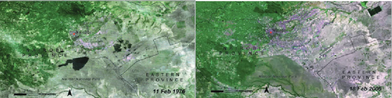
The most recent Master Plan for the City of Nairobi was published in 1973, at a time when large mammals were still to be found outside all of NNP’s urban boundaries. Since that time, pressure for land around NNP has steadily increased, and the park’s former buffer zones (west of Mombasa Road) have been progressively transformed for industrial and urban land uses. This changing landscape has been accompanied by an increase in human settlements – ranging from luxury homes to informal townships – and a number of traditionally municipal questions are now regularly on the agendas park managers: waste (both household garbage and industrial effluent/emissions), crime (firewood and game-meat poaching, theft/ vandalism of the park fence) and housing (both from illegal land-grabbing and legitimate real-estate speculation).
With little open space left in Nairobi’s urban fabric, the land around (and sometimes within) the NNP is increasingly coveted for uses other than conservation. Proposals for highways and dams have attempted to make use of the park’s territory, and in January 2011, an oil pipeline was constructed inside the park’s fence (Figure 2). Although this pressure was at first concentrated on the park’s
urban-facing boundaries, recent years have seen increased activity in the southern plains – far beyond the current Nairobi City limits. The built-up areas of Ongata Rongai and Kitengela are continually expanding, and a recently proposed “Greater Southern Bypass” would connect these two towns. Collectively, this development also cuts off the NNP from the plains upon which its wildlife depends.
Historically, the Athi-Kapiti plains have been home to Maasai pastoralists, who grazed their cattle on communally owned lands. In recent years though, urban pressures have raised the price of land, and thus incentivised the sale of individual plots. With less land available for grazing, Maasai pastoralists are less able to avoid the predators they’d traditionally co-existed beside. At the same time, the increasingly fragmented landscape renders pastoralism less viable, reinforcing the incentive to sell.
Greater Nairobi is expanding at a breakneck pace – and the needs of its growing population are real and pressing. Consequently, the gazetted territory of NNP is facing increasing threats and its larger wildlife catchment is rapidly transforming. Current trends appear to lead towards the loss of viable migration from Athi-Kapiti to NNP – with severe consequences both
3
for ecosystem function and Maasai cultural practice. As a recently launched initiative succinctly posts on billboards throughout the city: “Nairobi National Park is Under Siege.”
2- What’s Going On: Making sense of intricate interdependencies
In a setting as rich and diverse as this, trying to make sense of who does what – and why – is no easy task. A multitude of national, municipal, parastatal, industrial, pastoral, scientific, nongovernmental and private actors influences the long-term viability of Nairobi National Park; in turn, their efforts will ultimately structure the future landscape of Southern Nairobi. While some of these actors work cooperatively towards shared objectives, others seem to work at cross purposes – and none individually has enough spare capacity to take measured stock of the complex institutional landscape in which they operate. As a contribution to the Urban Protected Areas Network (in which IFRA is the lead scientific partner in Kenya) a team of four students from the Sciences Po Masters of Public Affairs spent the 2010-2011 working to explore this gap. Following a period of rigorous preparation in Paris, the team came to Kenya for a fortnight of intense fieldwork, during which they conducted 81 semi-directed interviews with the full range of people who share interests in or influence on the NNP. By systematically triangulating the information obtained through these interviews along with documentary resources, their research accomplished three main tasks: a) Identify actors that influence park & urban policy, and inventory the aims and effects of their individual efforts. b) Assess relationships between the various policies and management actions identified above, specifically analyzing how contradictions between them are resolved, how synergies between them are maintained, and what tradeoffs are inherent in this balance.
c) Appraise the overall integration of park & urban policy, identifying opportunities for further integration and considering the apparent cost/benefit to various actors of doing so.
The written results of this effort took the form of an Atlas of Aims, Effects, Synergies and Contradictions of Park & City policy along the urban edge of Nairobi National Park. In this text – and during oral presentations in Paris – the team first analyzed the historical and present state of affairs, and then identified four paths forward. For each of these scenarios, the team describes likely motivations for the implicated actors, and the trade-offs such actions would entail. Herewith a synthesis of the group’s observations and the possible futures they suggest:
Observation #1: Formal boundaries of NNP align poorly
with the ecosystem it is supposed to protect.
The gazetted boundaries of NNP were initially drawn as boundaries of convenience, based on the arbitrary limits imposed by a river, a railroad-track and the like. Over time, these boundaries have proven to be a generally effective barrier to land-use change within area they formally protect: land within them is largely protected, while land beyond them is increasingly transformed (Figure 3). However, as Nairobi continues to urbanise, the adequacy of these boundaries is doubtful, for two reasons.
First, the boundaries are permeable, and human activity just outside the park has a major impact on the environment within it. Decades of ad-hoc industrial and slum development have severely degraded land along the park’s Eastern boundary, some sections of which (near Cheetah Gate) no longer support healthy use by humans or wildlife.
Second, these historical boundaries demarcate but a small portion of the broader natural system, and the protection they afford does not extend to the adjacent areas of high conservation value. Seasonal wildlife migration extends to the south, where traditional pastoral practice has largely maintained the open space necessary for the viability of these movements. Today though, this migration is hindered by incremental land changes to land-use outside NNP, and the formal territory of this protected area is alone insufficient to guarantee the healthy function of its ecosystem.
4
Mambo! 2011 nº2 - HYMAN G. "Living on the Edge" - Nairobi National Park
Observation #2: Although some
actors debate the extent of animal movement across NNP’s southern boundary, all agree that obstacles to this migration continue to increase. Unless further action is taken to mitigate this, it appears inevitable that the migration corridor will eventually be severed.
As students of public affairs, the research team was without sufficient training to evaluate the various ecological claims they encountered about the current state of migration across the NNP southern boundary. Nonetheless, there was a general consensus among their interlocutors was that human activity disrupts the movement of animals – specifically when this activity involves the construction of barriers. As more land is sold, the number of fences multiplies, further limiting space for migration. Construction of major infrastructure (such as the proposed Greater Southern Bypass) will only exacerbate this constraint. In the absence of additional action to mitigate these changes, the prospects for this migratory corridor appear fatally bleak.
Obser vation #3: Permanent
disruption of this wildlife migration will have consequences both for the functioning of the Athi-Kapiti ecosystem (of which NNP is part) AND for the Maasai pastoralists who depend on this system for their livelihoods and cultural practice. The managers of NNP and pastoralists from the Athi-Kapiti plains have many common interests. Both depend on the availability of open space, and both struggle to adapt their practices to the consequences of land-use change. NNP benefits directly from the continued traditional practice of Maasai pastoralism, by virtue of the contiguous open space they use
for grazing. For this reason, park advocates have developed several mechanisms to support pastoral land-use (among them a Land Lease Program to discourage fences and a Consolation Scheme to mitigate the loss of cattle from predators). At the same time, pastoral communities benefit directly from the continued viability of wildlife migration between the Athi-Kapiti plains and the NNP. Maintenance of this corridor is a key argument for retaining this open space; should it be closed - by installation of a fence, building of a road or from a patchwork of property fences – this would undermine those arguments, imperilling Maasai cultural practice and livelihoods.
3- A look to the future: What to do about the park boundaries?
During the course of the students’ fieldwork, various actors they met would frequently raise the question of whether to fence the NNP southern edge. However, after closely analysing all of the data they collected, the team determined that this might not be the most prescient question to be asking. Rather – in light of the difficulty for current NNP boundaries to effectively protect the ecosystem it is supposed to preserve, a more meaningful question would be “What to do about the park’s boundaries?” As the actor most directly responsible for managing the NNP, the Kenya Wildlife Service (KWS) will necessarily be at the core of any answer to this question. With this in mind, the team elaborated four possible scenarios – each presuming a different answer to this question.
Future #1: Abandon the Boundaries:
Degazette NNP and concentrate conservation efforts in the South This action presumes that a severed migratory corridor would render the gazetted territory unsuitable for protection as a national park. Of the four possible futures, this scenario is simultaneously the most radical and the least feasible. Nonetheless, its implications are important to consider: if all connection to the Athi-Kapiti plains is truly disturbed beyond repair, the "raison d’être" for NNP might legitimately be questioned. Opening this previously protected land for new development could create opportunities for building innovative, sustainable settlements to meet the needs of Nairobi’s residents. Doing so would simultaneously reduce development pressure in the areas south of the existing park – where more viable populations of wildlife would presumably persist. As well, revenue streams from the new uses of this land could considerably contribute to conservation efforts in the places where they would be most effective.
However, if wildlife migration were still viable, undertaking such an action would be needlessly destructive and totally illegal. Furthermore, while wildlife is an important component of the NNP, this protected area also provides for a range of other ecosystem services. This action would also put those services at risk.
F u t u re # 2 : S t re n gt h e n t h e Boundaries: Fully Enclose NNP,
concentrating conservation efforts in the North
This action presumes that a severed migratory corridor would neutralize the ecological benefits of an unfenced boundary – and as such, the NNP
5
would be transformed into a closed ecosystem.
In many ways the opposite of Future #1, this scenario would redouble efforts to preserve viable wildlife populations within the NNP, which greater Nairobi would progressively encircle with ever-more intensive urbanization. Fully fencing the park would increase the complexity and cost of park management. At the same time, having undermined the main argument for preserving open space in the Athi-Kapiti plains, this action would exacerbate demand for that land, also complicating the traditional pastoral practice.
Though here again, if wildlife migration were still viable, building a fence would put a decisive end to this, on account of the development it would immediately invite and enable at the park’s southern edge.
Future #3: Maintain the Boundaries:
Strengthen existing programs to retain and restore migration
This action presumes that by effectively redoubling conservation efforts – both within and outside the NNP – the otherwise degraded migratory corridor can still be restored. Such efforts would foster a mutually beneficial cooperation between KWS and the pastoral communities south of NNP, both of whom share in interest in limiting – and eventually reducing – the number of physical barriers to animal movement. One mechanism for this (among many) could be a strengthened Land Lease Program, which would also serve to support Maasai culture and livelihoods. At the same time, viability of migration and of pastoralism would be supported by more meaningfully integrating their shared open-space requirements into the planning tools that determine how land in the Athi-Kapiti ecosystem
will be used.
Such actions only make sense if wildlife migration is still viable. Although pastoralists would benefit from the continuation of lease payments, in the absence of migrating animals, renewed investment to prevent additional fences would be futile.
Future #4: Amend the Boundaries:
Reshape NNP to better protect broader ecosystem function
This action presumes that to restore and maintain viable wildlife migration, the functional boundaries of this protected area must better align with the territory that supports the underlying ecosystem. To accomplish this, two interrelated changes would be made to the gazetted borders of NNP.
First, beginning with the most vulnerable parcels, additional land to the south of NNP would be acquired for inclusion in the jurisdiction of the protected area. Regardless of which mechanism is employed to this end, the aim remains the same: to ensure the perpetual availability of this land for the free function of ecological processes.
Second, in order to finance the abovementioned acquisitions – KWS would divest of otherwise degraded lands along the urban-facing boundaries of the NNP. As the land nearest to Nairobi city-centre is much more expensive than more remote parcels in the Athi-Kapiti plains, trading small plots of the former for large tracts of the latter would increase the conservation value of the whole. Provided strict development controls were enforced on the newly-divested land, the park would additionally benefit from more appropriate buffers than the current arrangement can offer. To some degree, land allocated for
the Nairobi Green Line is a de facto example of this; but other uses (such as warehouses or residential housing) could be compatible at other points along the eastern boundary.
Unlike the other three scenarios, this action is of the “no regrets” variety. If wildlife migration is currently still viable, extending the jurisdiction of NNP would serve to ensure its long-term preservation. However, if the landscape is already transformed to the point that animals can no longer move between the park and the plains, removing barriers is the best hope for restoring a viable seasonal migration. In either case – as traditional pastoral practice is largely compatible with wildlife migration – this action would also serve to support Maasai culture and livelihoods.
6
Mambo! 2011 nº2 - HYMAN G. "Living on the Edge" - Nairobi National Park
Project Limitations and Future Research Directions
A study as brief as this could never satisfactorily consider all the dimensions present in so complex a system as greater Nairobi and its namesake national park. To some degree, this project has overstated the relative importance of wildlife migration (relative to other values offered by the NNP). In particular, the team would have also liked to study the role of NNP in the provision and regulation of freshwater. Also, analysis of the direction Nairobi is growing (horizontally vs. vertically) may have provided additional alternatives for managing pressure on scarce open-space. Finally, more detailed consideration of each possible future would have allowed more precise evaluation of the trade-offs they imply. Future research could productively concentrate on any of these points. Likewise, a sensible and meaningful assessment of the implied linkage between Maasai cultural practice and functional wildlife migration would also be very instructive.
Although the work of this project was to identify trade-offs for all actors – decisions about the future of this landscape will necessarily be those who directly manage the protected area, as well as the authorities that share jurisdiction over adjacent land. Each of the above possible futures is implicitly informed by the ecosystem approach (www.cbd. int/doc/decisions/cop-07/cop-07-dec-11-en.doc); accordingly, it is the hope of this young researchers team that their work might assist these actors in finding win-win solutions at a meaningful ecosystem scale.
Glen Hyman, Capstone Leader
Centre de Sociologie des Organisations (CNRS / Sciences Po) About the Learning Partnership
The Master of Public Affiairs (MPA) at Sciences Po provides an interdisciplinary training in applied, action-oriented and comparative social science, as well as training in leadership, strategy and ethics. As a critical component of the second-year curriculum, the Capstone project is a group research project, based on original field research, which generates a deliverable product for the client.
The Urban Protected Areas (UPA) Network began in 2009 at the initiative of the Institut Libertas and the Gecko Laboratory of l’Université Paris Ouest-Nanterre-La Defènse. It is an international, independent, decentralized and non-profit network, which brings together protected area managers, local authorities, representatives of civil society and teams of researchers, to collaborate on Urban-Nature issues, with particular attention to the role of protected areas in urban dynamics. The UPA Network now partners with the MPA as its client for a series of “Living on the Edge” Capstone projects.
The research section of the Institut Français de Recherche en Afrique (IFRA-Nairobi) promotes the
crea-tion of networks and acts as a catalyst for scientific exchange between French, European and East African
researchers and organizations. As the lead scientific partner of the UPA Network in Kenya, IFRA-Nairobi
collaborates with the MPA to provide financial and scientific support for this Capstone project on Nairobi
and its namesake National Park.
The student research team included James Canonge, Sharon Gil, Fatima Hassanova and
Nastassia Kantorowicz Torres.
Glen Hyman holds a humanities degree from the University of Chicago, a Geography Masters from the Université de
Paris-Sorbonne (Paris IV), and is currently concluding his studies with the Center for the Sociology of Organizations (CSO). Cur-rently focused on the complex relationships between nature and cities.
MAMBO! presents recent researches from IFRA associated scholars
Directeur de l'IFRA: Christian Thibon ; Mambo! edited and designed by Amélie Desgroppes