HAL Id: hal-02397686
https://hal.umontpellier.fr/hal-02397686
Submitted on 6 Dec 2019
HAL is a multi-disciplinary open access
archive for the deposit and dissemination of
sci-entific research documents, whether they are
pub-lished or not. The documents may come from
teaching and research institutions in France or
abroad, or from public or private research centers.
L’archive ouverte pluridisciplinaire HAL, est
destinée au dépôt et à la diffusion de documents
scientifiques de niveau recherche, publiés ou non,
émanant des établissements d’enseignement et de
recherche français ou étrangers, des laboratoires
publics ou privés.
Estimate the risk of soil erosion using USLE through the
development of an Open Source desktop application:
DUSLE (Desktop Universal Soil Loss Equation)
Fatima Hara, Mohammed Achab, Anas Emran, Gil Mahe, Badr El Fhel
To cite this version:
Fatima Hara, Mohammed Achab, Anas Emran, Gil Mahe, Badr El Fhel. Estimate the risk of soil
ero-sion using USLE through the development of an Open Source desktop application: DUSLE (Desktop
Universal Soil Loss Equation). 3rd International Conference on African Large River Basins Hydrology,
May 2018, Alger, Algeria. �hal-02397686�
3
RDInternational Conference On African Large River Basin Hydrology (ICALRBH)
Estimate the risk of soil erosion using USLE through the development of an Open Source desktop application:
DUSLE (Desktop Universal Soil Loss Equation)
Fatima Hara
1,*, Mohammed Achab
1, Anas Emran
1, Gil Mahe
2, Badr EL Fhel
3 1Geo-Biodiversity and Natural Patrimony Laboratory(GEOBIO,)Scientific Institute,Geophysics, Natural Patrimony and Green Chemistry Research Centre(GEOPAC), Mohammed V University in Rabat. fatimahara1@gmail.com.
2 HydroSciences Montpellier / IRD, France.
3 Université Hassan II - Casablanca, Faculté des sciences - Ain Chock.
Highlights: - Development an open source application of soil erosion risk DUSLE (Desktop Universal Soil Loss Equation). -. Predict the average soil loss.
Keywords: Water erosion, Loss in soil, USLE model, DUSLE development, Open Source, java, watershed.
1. Introduction
Water erosion is the main factor of the deterioration of the soil resource. The soil loss phenomena have accelerated around the world (De Graaf, 1996). Water erosion risk assessment involves mapping and analyzing many factors involved in the erosive process: rainfall erosivity, soil erodibility, slope length, vegetal cover (Wischmeier and Smith, 1978).
The development of computer tools and Geographic Information Systems (GIS) have facilitated and solved the problems of water erosion through modeling. In this context, our main objective is to develop a desktop application for open source soil erosion risk using the USLE empirical equation. The source code of the application can be used, modified and improved by all users.
2. Material and Methods Development tools
Java
Java is an object-oriented computer programming language for developing applications. This language is intended to work in multiple computer environments and on different types of computers.
Netbeans
Netbeans is an integrated development environment (IDE) for Java, placed open source by Sun in June 2000. It also supports different other languages, such as Python, C, C ++, PHP, XML and HTML.
DUSLE desktop application
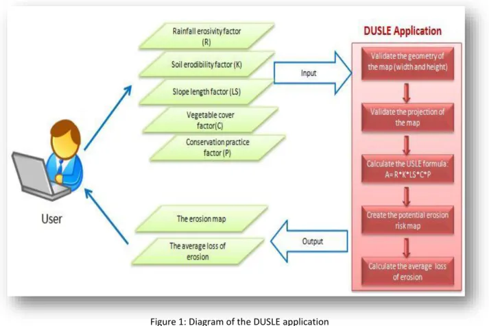
The desktop application DUSLE was composed of an interface with six button. Each button allows to load a factor involved in the USLE method, the last button allows to define the result path. The calculated button allows to create the USLE map which combines the five factors previously loaded via the directory path in picture format (jpg),(Conservation practice factor (P) is considered a number between 0 and 1), and calculate the average loss. Two buttons were added to interface with the intuitive functionality, Help button & Cancel button. The application can be easily installed on a PC with desktop shortcut and practical interface.
Figure 1 shows the general methodological organization followed in this work, and the development of the proposed DUSLE application.
Figure 1: Diagram of the DUSLE application
3. Results and Discussion
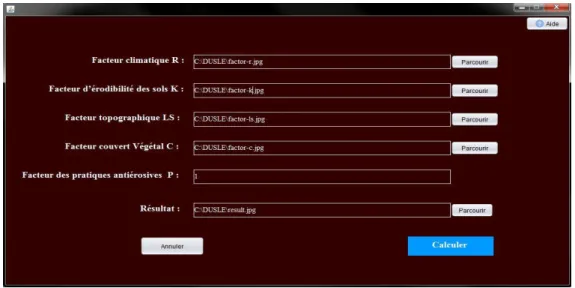
The developed application has been tested in an area near the " Sidi Mohammed ben Abdallah Dam " located north west of Morocco. The spatial resolution of the raster files used in this case study was defined as 5 m. This resolution is the same of the DEM used. All the data were in the Merchich/North coordinate reference system (EPSG: 26191). The interface screen is shown on figure 3.
DUSLE application interface
Figure3: DUSLE interface for each USLE parameter
Comparing the results of the DUSLE application and ArcGis software
The analysis of the risk map of soil erosion obtained via DUSLE application (Figure 4a) and that obtained via ArcGIS (Figure 4b) are similar. We are in the process of developing the DUSLE application for better results. The average soil loss values in the chosen zone obtained by DUSLE is close to the value obtained via ArcGis.
Figure 4a: The soil erosion risk map on DUSLE (Open source).
Figure 4b: The soil erosion risk map on Arcgis (proprietary
software).
4. Conclusion
DUSLE application that we developed in this work allowed us to estimate the risk of soil erosion over the chosen area. The results obtained from the DUSLE application are similar to those obtained by USLE via ArcGis. These preliminary results are suitable for further uses.This work opens the way for broad use of programming for geoprocessing desktop or online at Morocco from open source tools.
5. References
De Graaf, J. (1996). Price of soil erosion: an economic evaluation of soil conservation and watershed development, Landbouwuniversiteit Wageningen (LUW), Wageningen, 300 pp.
Wischmeier, V. H., & Smith, D.D. (197)8. Predicting rainfall erosion losses- a guide to conservation planning. United States Department of Agriculture in cooperation with Purdue Agricultural Experiment Station. United States Department of Agriculture, Washington. Agriculture Handbook No. 282.