Full Terms & Conditions of access and use can be found at
https://www.tandfonline.com/action/journalInformation?journalCode=tgda21
Geodinamica Acta
ISSN: 0985-3111 (Print) 1778-3593 (Online) Journal homepage: https://www.tandfonline.com/loi/tgda20
Historical fluvial palaeodynamics and multi-proxy
palaeoenvironmental analyses of a palaeochannel,
Allier River, France
A. Ejarque, A. Beauger, Y. Miras, J.-L. Peiry, O. Voldoire, F. Vautier, M.
Benbakkar & J. Steiger
To cite this article: A. Ejarque, A. Beauger, Y. Miras, J.-L. Peiry, O. Voldoire, F. Vautier, M. Benbakkar & J. Steiger (2015) Historical fluvial palaeodynamics and multi-proxy
palaeoenvironmental analyses of a palaeochannel, Allier River, France, Geodinamica Acta, 27:1, 25-47, DOI: 10.1080/09853111.2013.877232
To link to this article: https://doi.org/10.1080/09853111.2013.877232
© 2014 Taylor & Francis Published online: 20 Mar 2014.
Submit your article to this journal Article views: 699
View related articles View Crossmark data
Historical
fluvial palaeodynamics and multi-proxy palaeoenvironmental analyses of a
palaeochannel, Allier River, France
A. Ejarquea,b,c*, A. Beaugera,b, Y. Mirasa,b, J.-L. Peirya,b, O. Voldoirea,b, F. Vautiera,b, M. Benbakkard,e,fand J. Steigera,b
a
Clermont Université, UBP, MSH, 4 rue Ledru 63057, Clermont-Ferrand Cedex 1, France;bCNRS, UMR 6042, GEOLAB– Laboratoire de géographie physique et environnementale, Clermont-Ferrand 63057, France;cSchool of Earth Sciences & Environmental Sustainability, Northern Arizona University, Box 5694, Flagstaff, AZ 86011, USA;dClermont Université, Université Blaise Pascal, laboratoire Magmas et Volcans, BP 10448 F 63000, Clermont Ferrand, France;eCNRS, UMR 6524, LMV, F-63038,
Clermont-Ferrand, France;fIRD, R163, LMV F-63038, Clermont-Ferrand, France (Received 21 February 2013;final version received 9 December 2013)
A palaeoenvironmental study of a palaeochannel within the lower alluvialfloodplain of the Allier River, France, has been carried out at a high temporal resolution. Research was based upon a multi-proxy approach using different sedimentological (magnetic susceptibility, sediment texture and loss on ignition) and palaeoecological (pollen, non-pollen palynomorphs (NPPs), diatoms – indicators). The palaeochannel was dated from six radiocarbon dates and spans from the second to the eleventh century AD. The cultural landscape history of thisfloodplain and the progressive hydrological disconnection of the palaeochannel between the Antiquity and the early Middle Ages could be recon-structed according to several characteristic environmental phases. Co-inertia analysis linking pollen, NPPs and diatom corroborated the significant co-structure of these proxies and allowed to distinguish functional palaeoecological groups in terms of landscape openness, on-site aquatic and hygrophilous vegetation, riparian woodland, soil moisture and graz-ing pressure. Results obtained underpin the importance of grazgraz-ing as a major agent of landscape change infloodplains, especially since the ninth century AD, when the clearance of the riparian woodland is attested. Gallo-Roman and Late-Antiquity land-use systems, on the contrary, allowed for the preservation of riparianfluvial landscapes.
Keywords: Palaeoenvironment;fluvial palaeodynamics; multi-proxies; sedimentology; pollen; non-pollen palynomorphs; diatoms; grazing pressure; Allier River; France
Introduction
Riverfloodplains and riparian zones are among the most dynamic, diverse and complex ecosystems on earth with fluvial, hydrogeomorphic and land use processes acting on them (Naiman, Décamps, & Pollock, 1993; Steiger, Tabacchi, Dufour, Corenblit, & Peiry, 2005; Tockner et al.,2008). Covering only about 2% of the land surface and providing 25% of all continental ecosystem ser-vices, they are considered among the most productive environments in the world (Tockner, 2013). Despite the recurrent risk of flooding, they were over very long timescales highly attractive environments for human societies. Floodplains provide multiple natural resources and environmental services which have been exploited for centuries and even millennia, e.g. drinking water supply, grazing and arable lands, fishery and timber production. The attractiveness of European floodplains for human societies in the past is demonstrated by numerous archaeological settlements, some of them dating back to the Mesolithic period (e.g. Bonsall et al.,
2004; Brown,2009; Orengo, Ejarque, & Albiach, 2010; Tockner, Uehlinger, & Robsinson,2009). Our study area, the Allier valley, is also underpinned as an attractive area for human societies since the Neolithic and the Bronze Age (Dartevelle, Liabeuf, & Rialland, 2004; Liégard & Fourvel, 2004). Today, fluvial corridors, river and
floodplain systems are among the most threatened ecosystems in the world as a major consequence of such a long and intense human occupation, transformation and exploitation (Vitousek, Mooney, Lubchenco, & Melillo,
1997). In Europe, more than 90% of former floodplains have either disappeared or been transformed into croplands and urban areas (Tockner, 2013). Recently, the European Environment Agency (2013) underpinned the strategic importance of both (i) river floodplain management for the preservation or restoration of its ecological and hydrogeomorphic functioning and (ii) flood prevention in future decision-making. Such apparently antagonistic objectives need to consider a functional compromise between society and floodplain systems, i.e. a situation in which the functioning of soci-ety and ecosystems are conjointly optimized (Corenblit et al., 2013). Also, the long historical occupation and modification of river–floodplain systems need to be con-sidered in order to understand their current structure and functioning and to develop adequate and sustainable management strategies (Dai et al., 2009).
The palaeoecological analysis of biotic and abiotic indicators, such as pollen, diatom or sediment struc-ture and texstruc-ture, can significantly contribute to our knowledge of the long-term evolution and shaping of fluvial landscapes (e.g. Brown, 2009; Gell et al., 2005;
*Corresponding author. Email:Ana.Ejarque@nau.edu
© 2014 Taylor & Francis
Schönfelder & Steinberg, 2004). However, the scarcity of lakes and mires where pollen, diatom and other biotic remains can deposit and preserve has hampered palaeo-environmental analyses in fluvial areas. In the last decade, different multi-proxy palaeoecological studies have stressed the suitability of organic-rich palaeochan-nel infills for the palaeoecological reconstruction of Europeanfloodplains (Brown, 2009; Erkens et al.,2009; Hilt et al., 2008; Magyari, Jakab, Sümegi, & Szöor,
2008; Parker et al., 2008; Smith, Fletcher, Head, Smith, & Howard, 2010). However, despite this increasing interest in the analysis of floodplain sediments, palaeo-ecological studies of palaeochannels are still rare. In France, multi-proxy palaeoecological studies comprising biotic and abiotic analyses have focused on the rivers Seine (Leroyer, 1997; Pastre, Limondin-Lozouet, Leroyer, Ponel, & Fontugne, 2003), Rhône (Argant, Bravard, Bourguignon, & Béal,2011; Limondin-Lozouet et al., 2002; Salvador, Berger, Fontugne, & Gauthier,
2005), Loire (Carcaud, Garcin, Visset, & Burnouf,
2002; Cyprien, Visset, & Carcaud, 2004) and Garonne (Leroyer, Fouere, Reynet, Tixier, & Allenet, 2006). However, high resolution and well-dated late Holocene profiles are still rare in French floodplains especially in the Massif Central, where no multi-proxy palaeoeco-logical research has been conducted so far.
Here, we present a multi-proxy and high resolution palaeoecological study of a palaeochannel spanning the Gallo-Roman and the early Middle Ages. This record is important in providing critical palaeoecological evidence for a period which is still little known in the archaeologi-cal and historiarchaeologi-cal record of this region of the Allier valley. Abundant human settlements and archaeological artefacts are documented on the Allier fluvial terraces during the Gallo-Roman period (e.g. Lallemand, 2001; Lallemand & Vallat, 2001) and numerous Medieval churches, burials, fortifications and windmills are reported in the archaeological database of the French Allier Department (Service Régional de l’Archéologie,
2011). However, much of this information is related to occasional surface finds accounting for very general chronologies and rescue archaeological operations mainly focused in urban areas. This contrasts with nearby areas at the upper Allier valley such as the Limagne, where abundant archaeological information is available for both the Antiquity and the Middle Ages (Trément,2011).
Local scale studies are considered to be the most suitable approach for analyzing human–environment interactions (Dearing, Battarbee, Dikau, Larocque, & Oldfield, 2006). Therefore, we placed a particular emphasis on using palaeoecological bioindicators provid-ing local information, in particular pollen, diatoms and non-pollen palynomorphs (NPPs). The latter two are of significant importance when coupled with pollen analysis for (i) determining past fluvial environmental conditions (e.g. water table oscillations, nutrient levels), (ii) reconstructing past aquatic and riparian on-site vege-tation assemblages and (iii) documenting local land-use
changes (Ejarque, Miras, & Riera, 2011; Smol & Stoermer, 2010; van Geel, 2001). Despite their potential, diatoms and NPPs have been poorly used in the analysis of palaeochannels. Here, for the first time, a comprehen-sive use of NPPs found in palaeochannel infills was made in order to study thesefluvial palaeoenvironments.
The main objectives of this study are (i) to under-stand the hydroecological, geomorphic and sedimentary palaeofunctioning of the palaeochannel, (ii) to recon-struct the evolution of riparian and cultural vegetation within the fluvial corridor, (iii) to identify human activi-ties and their impacts on the fluvial landscape between the Antiquity and the Middle Ages and (iv) to evaluate how human activities may have changed environmental resources provided to society.
Material and methods Study site
Our palaeoenvironmental study was carried out on a palaeochannel within the Holocene floodplain of the lower Allier River, France (Figure 1). The Allier River is a tributary of the Loire River in France. In the upper Loire basin, the Allier alternately flows through gorges and small alluvial plains within the Massif Central’s basement domain, with volcanic, granitic and metamor-phic rocks. The selected study site is located within the tectonic basin of the Allier River downstream section. Here, the Allier is a highly dynamic meandering river with little river training works. This river section was classified as a natural reserve Réserve naturelle nationale du Val d’Allier in 1994.
The Allier River presented a multi-thread planform at the end of the nineteenth century until about the 1950s (Peiry, Petit, & Lepicek, 2009). Its planform then progressively changed to a simplified style with a single-thread channel becoming more and more sinuous, but keeping a high lateral mobility (Petit, 2006). The numer-ous palaeochannels within the Holocene floodplain reflect the past lateral mobility of this river. Palaeochan-nels are found at different topographic levels, indicating different ages. Altitude measurements were taken along a transect within the river corridor (Figure 1). The river margins of the present channel are at 221.2 m a.s.l., whereas the study site is at 222.5 m a.s.l. The distance between the main channel in its present location and the study site is 2500 m. Today, the study site is occupied by a poplar plantation, pastures and croplands extending on the surrounding floodplain. Poplar (Populus sp.) and willow (Salix sp.) dominate the riparian woodland on the river corridor’s channel margins.
Coring and cross-sections
Palaeochannels within the Allier floodplain were identified and located, through the combined use of topographic maps (1/25000), historic maps from the eighteenth-nineteenth centuries and aerial photographs
and field survey. The selected palaeochannel was located next to the so-called Camp des Romains, i.e. a local name meaning the “romans’ camp” still figuring on the topographic maps. Hereafter, we refer to the sediment core taken on this site as “CdR”. This palaeochannel was chosen because initial coring
with an auger indicated the existence of organic matter within the palaeochannel sediments, which assured both radiocarbon dating and the study of biomarkers.
In September 2009, coring was performed in the apex axis of the former channel using a motorized core
Figure 1. Localization of the palaeochannel Camp des Romains (star) within the Allierfloodplain, upstream of the town of Moulins and close to the village of Châtel-de-Neuvre (black square). The digital elevation model was built using photogrammetry based on aerial photographies from 2009 (source: Centre Auvergnat de l’Information Géographique – CRAIG; resolution of images: 10 m) (created by F. Vautier). Black arrows indicateflow direction. The dotted line indicates a transect between the present main channel and the study site on which altitudes were determined.
Figure 2. Surface cross-section across the palaeochannel along the axis of the apex, bottom of the palaeochannel corresponding to the layer of coarse sand (former bedload), sediment log determined from one core (CdR) and sediment logs determined from auger samples (A1–A5).
sampler Geotool GTR 790. Three 1 m long core segments 8 cm in diameter were sampled (location: E: 727080.17 N: 6590071.32 m, Lambert 93; altitude: 221.38 m a.s.l.). The maximum 3 m depth was determined by a layer of coarse sand and gravel which represent the bedload on the former channel bottom (Figure 2). The cores were taken to the laboratory, cut horizontally into two semi-cores, photographed and qualitatively described. Since sediments were partially compressed during coring, layer depths were corrected according to the degree of compression dependent on grain size.
Sedimentary analyses concerned the stratigraphic record as a whole, from the channel bottom to the top of the sequence (total depth of 3 m). However, both loss on ignition and the palaeoecological analysis were only performed within fine deposits located in the medium sequence (−60 to −230 cm) since the top layers (colluvium) and the coarse sand from the channel bottom were found to be very poor in diatoms and pollen. Subsampling of the silt-clay palaeochannel sediment was undertaken at 2.5 cm intervals for sedimentary, pollen, NPPs and diatom analyses.
In addition, a topographic survey with the combined use of a GPS (GPS Leica System 500) and a total station (Pentax W800) was carried out in order to obtain the topographic surface cross-section of the palaeochannel across the axis of the palaeochannel apex. The bottom of the palaeochannel infill, which corresponds to coarse sand transported as bedload before the hydrological disconnection of the channel, was reconstructed using a set of auger holes (Figure2).
Radiocarbon dating
Six 14C AMS dating measurements were performed by Beta Analytic Inc (Miami) and the Poznan Radiocarbon Laboratory (Poland) along CdR stratigraphic record. Radiocarbon dates were obtained within the organic section of the core. Organic matter, mainly consisting in fine layers of leaves, wood and plant remains, is only present within silt and clay sediments, sand being sterile. Samples collected in the highest position of the strati-graphic record are bulk (−103 cm) and charred material (−83 cm). 14
C dates were calibrated using the OxCal 4.1.7 software (Bronk Ramsey, 1994; atmospheric data from Reimer et al.,2009).
Sedimentology
Magnetic susceptibility was directly determined every 1 cm on one semi-core using a MS2 magnetic susceptibil-ity meter with a MS2E surface scanning sensor. Organic matter content was determined by loss on ignition at 550 °C (Nabertherm 1200 °C PROG 2 PA oven). Sub-samples (every 5–10 cm) were oven dried at 60 °C and organic matter of fine sediment was destroyed using hydrogen peroxide (H2O2). These samples were
treated with potassium chloride (KCl) and sodium metaphosphate (NaPO3).
Sand grain size distribution of the former palaeo-channel bedload was determined by sieving, whereas the fine sediment palaeochannel infill was determined by laser diffraction (Coulter laser sizer LS230). Grain size indices were calculated using grain size distribution and statistics package for the analysis of unconsolidated sediments GRADISTAT 8.0 (Blott & Pye, 2001). Trans-port and sedimentation processes of the sediment were interpreted using the Passega or CM diagram (Bravard & Peiry,1999; Passega,1964).
Pollen and NPPs analyses
About 1 cm3 samples were prepared for pollen analysis following standard procedures (Faegri & Iversen, 1989) including treatment with KOH, sieving at 200μm, hot HF, HCl, heavy liquid separation (ZnCl2), acetolysis and
mounting in glycerine jelly. Pollen and NPPs were identified and counted on a Leica DM 2500 M micro-scope at 500× and 1000× magnification. Identification followed published illustrations and morphological keys (Beug, 2004; Moore, Webb, & Collinson, 1991; Punt, Blackmore, Hoen, & Stafford, 1976–2009; Reille, 1992; van Geel, 2001; van Geel & Aptroot, 2006) and the GEOLAB pollen reference collection. NPP types were assigned to an existing code when already described in the catalogue of the Hugo de Vries Laboratory, Univer-sity of Amsterdam (Netherlands). At least 450 dry land pollen grains were counted per sample, together with those NPPs simultaneously identified. Pollen and NPP values are expressed as a percentage of total pollen excluding Cyperaceae, fern spores and aquatic plants. Lycopodium clavatum spore tablets (Stockmarr, 1971) were added in order to calculate pollen concentrations, which are expressed in grams of dry sediment. Data were assigned to the following ecological groups in accordance with local and regional vegetation descrip-tions (Bournérias, Arnal, & Bock, 2001; Loiseau & Felzines, 2004; Schnitzler, 1996): (i) riparian hardwood, (ii) riparian softwood, (iii) reed bed and (iv) aquatics. The apophytes summary curve includes pollen taxa indicative of human impact (Behre, 1981) and the coprophilous fungi curve groups dung-related fungal spores (Ejarque et al., 2011; van Geel & Aptroot, 2006). In total, 27 samples were counted along the core, representing time intervals between samples of ca. 65 years in the lower part of the core and ca. 35 years in the upper part.
Diatom analysis
Samples for diatom analysis were taken at the same pollen intervals. A known quantity of sediment (around 0.5 mg) was cleaned using 30% hydrogen peroxide and diluted hydrochloric acid before being mounted in Naphrax (cf. Prygiel & Coste, 2000). Diatoms were
identified according to several encyclopaedias (Krammer & Lange-Bertalot, 1997a, 1997b, 2000a, 2000b, 2004) and other works (Germain,1981; Krammer,2000, 2002, 2003; Lange-Bertalot, 2001). Four hundred or more diatom valves were counted in each sample and subse-quently examined with a Leitz microscope at 1000x magnification. This allowed estimating diatom abundance (density/103 ind/mg) as the number of valves/mg dry weight of sediment using a quantitative method. The quantitative counting method is based on counting diatom valves by light microscopy with magnification of 1000x along transects in one of three aliquot drops (0.5 ml). Depending upon diatom concentration, the aver-age of 50 or 200 fields of view is used. The standard error for determining the total number of valves by this method does not exceed 15% (Khursevich et al.,2001).
Percentages of particular ecological groups were computed by means of OMNIDIA version 5.1 software, which includes a database of more than 11,000 species (Lecointe, Coste, & Prygiel, 1993). Most of the taxa have fairly well-defined ecological characteristics. Only for some of them information is missing.
A diatom-based quantitative total organic carbon (TOC) and total phosphorus (TP) were inferred using the available European diatom TOC and TP training sets of EDDI. Environmental reconstruction was made by modern analog technique reconstruction using the ERNIE 1.2 software package within EDDI (Juggins, 2001). Following this, 94 species were selected corresponding to taxa > 0.5% of relative abundance. The number of com-mon species between the best-performed training set and fossil samples was 48 for TOC and 39 for TP.
Data analysis
Pollen, NPPs and diatom stratigraphic diagrams were produced using PSIMPOLL 4.26 (Benett, 2005) and graphed using C2 software version 1.7.2 (Juggins,2011). Pollen and diatom biostratigraphical zones were established according to major changes in assemblage composition using the CONstrained Incremental Sum of Square cluster analysis (CONISS, Grimm, 1987). Percentages were square root transformed and only taxa with values≥1% in at least one sample were retained for cluster analysis.
Moreover, pollen, NPPs and diatom data were analyzed with a principal component analysis (PCA) on log-transformed data using a correlation matrix. Then, a
co-inertia analysis (COIA) was performed on the PCAs to analyze the co-structure of the two matrixes. The sta-tistical significance of the analyses was tested through a Monte Carlo random re-sampling test using 1000 random permutations (p-value ≤0.05). ADE4 in R 2.10.1 provided the software for these calculations (R Develop-ment Core Team,2004).
Results
Age-depth model
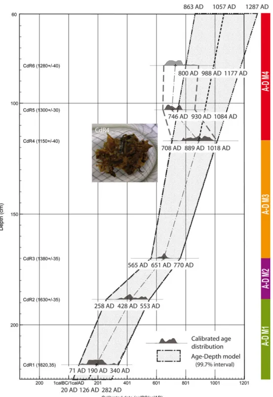
Radiocarbon dates for CdR are presented in Table 1. Most 14C dates were performed either in wood fragments or vegetal macroremains to avoid old wood effects usu-ally reported in palaeochannel bulk sediment (Berger, Salvador, Franc, Verot-Bourrely, & Bravard, 2008). An age-depth model has been established plotting calibrated radiocarbon dates vs. depth and assuming constant sedimentation rates between adjacent pairs of dates (Figure 3). Dating showed a very consistent age-depth model from the bottom (CdR1) to the −117 cm level (CdR4). However, dates determined from bulk and charred remains (CdR5 and CdR6) in the upper part of the stratigraphic record were 90 and 60 years, respec-tively, younger than CdR4 date. Contrary to CdR5 and CdR6 radiocarbon dates which may be aged due to a reservoir effect, we gave a strong confidence to the CdR4 date since it came from very well-preserved leaf remains (see photograph on Figure 3). Thus, we did not use radiocarbon results obtained from bulk and charred remains for the age-depth model’s construction. Instead, we extrapolated the most confident range of dates on macro-remains, i.e. CdR3 and CdR4, towards the top of the stratigraphic record (Figure 3), assuming a degree of uncertainty of our age-model for the uppermost 60 cm of the core.
According to the age-depth model, deposition rates ranged between 0.08 and 0.32 cm year−1. Three changes are relevant along the core (Figure 3): between −226 and −188 cm (A-DM1) sedimentation rate is 0.13 cm year−1, decreasing to 0.08 cm year−1from−188 to −177 cm (A-DM2) and strongly increasing to 0.22 cm year−1 between −170 and −117 cm (A-DM3). Considering that the two uppermost dates are aged and assuming that the age-model follows the same pattern as A-DM3, deposi-tion rates above -117 cm (A-DM4) show a hypothetical similar high sedimentation rate of 0.32 cm year−1.
Table 1. References of organic samples, type of material, depths and calibrated radiocarbon results.
Sample reference Sample code Material Depth (cm) AGE14C BP +/− Calibrated date (99.7%, AD)
CdR6 Beta-294429 Charred material −83 1280 40 650–866
CdR5 Poz-33816 Bulk −103 1300 30 647–860
CdR4 Beta-294430 Leaves −117 1150 40 708–1018
CdR3 Poz-33817 Wood −170 1380 35 565–770
CdR2 Poz-33865 Wood −188.5 1630 35 258–553
Sedimentology
Statigraphic description and main results of magnetic susceptibility, grain size distribution and LOI are presented in Table2and displayed in Figure4.
Pollen and NPPs results
CONISS cluster analysis has distinguished four pollen zones at CdR and their main pollen and NPPs results are
described in Table 3. Selected percentage pollen and NPPs curves are displayed in Figures 5and 6.
Diatom results
Four diatom zones and two subzones have been established by CONISS cluster analysis. Main results are presented in Table 4 and selected percentage diatom curves are displayed in Figures 7and 8.
Figure 3. Age-depth model of CdR using calibrated radiocarbon dates (see text for details).
T able 2. Statigraphic description and sedimentary results including magnetic susceptibility , grain size distribution and LOI obtained from the Cd R core. Zones cm Description CdR-S1 − 300 to − 230 This fi rst deposit consists of a thick, homogeneous and well-sorted layer of coarse sand (3000 < D50 < 3800 μ m). A thin layer of fi ner sand (D 50 ≈ 1400 μ m) and oxidization brie fl y interrupts the sequence between − 276 and − 283 cm. Magnetic susceptibility is high and noisy , its variability certainly being linked to the absence of fi ner particles other than medium sand. The CM pattern shows a sediment transport process of graded suspension (mainly saltation and some rolling) attesting the presence of a high level of turbulence and rapid fl ows in a still active main river channel CdR-S2 − 230 to − 182 Above fl uvial sands, transport processes of the deposited sediment drastically change and sediment size strongly decreases to rather well-sorted gray to dark gray silt (D 50 ≈ 20 –30 μ m). Magnetic susceptibility remains as high as in the previous phase but less variable, which is explained by the absence of coarse particles in the sediment. Several or ganic layers composed by wood remains are present between − 212 and − 182 cm, but they do not af fect the or ganic content of the sediment. Fluvial process reconstruction on CM pattern shows a uniform suspension transport, indicating that it most likely occurred just after the channel cut-of f CdR-S3a − 182 to − 140 Sediment size decreases again to gray fi ne silt (D 50 ≈ 10 –19 μ m) and sorting is degraded. Magnetic susceptibility remains weakly dispersed, but it decreases to a mean value of ≈ 100 SI, probably because of fi ne sand deposits ’ content, which remains around 20%. Only one thin layer of or ganic matter has been detected at − 170 cm. On the other hand, compared to other strata, the sediment or ganic content is high (15 –20%). This suggests a strong autogenic functioning of the palaeochannel, implying the presence of a high water level and the persistence of anaerobic conditions CdR-S3b − 140 to − 108 In comparison with CDR-S3a, sediment size and magnetic susceptibility are unchanged. However , o rganic content decreases by a factor of 2, which suggests a less permanent submersion than before. Fluvial process reconstruction on CM pattern shows a uniform suspension transport with a very weak turbulent current, suggesting a strong disconnection from the main river channel CdR-S4 − 108 to − 60 This very homogenous layer of gray clay silt is the fi nest of the whole core (5 < D50 <9 μ m). The sediment is poorly sorted. Magnetic susceptibility is near 0 SI, in close relationship with the quasi absence of fi ne sand in the sequence (less than 12% on average). T w o fi ne layers of or ganic matter (bulk and charcoal) have been identi fi ed at − 103 and − 83 cm depth, but the top of the sequence is sterile. Fluvial process reconstruction on CM pattern shows a very slow transport in uniform suspension before sedimentation, the river main channel remaining still the main source of mineral sediment during overbank fl ooding CdR-S5 − 60 to 0 This fi nal zone is very dif ferent from the previous ones: except for a fi ne silt transitional layer (E on Figure 4 ), deposited sediment consists of ochre to brown coarse sand from an origin other than the Allier River itself. Sediments are also less well-sorted than bottom sands from S, suggesting their closest origin. As previously seen on S1, magnetic susceptibility is high and very noisy due to the heterogeneity of coarse sands. Despite the absence of a well-marked or ganic layer , roots are abundant in deposits located near the surface. Fluvial process reconstruction on CM pattern shows a very turbulent transport in saltation, suggesting a colluvial sediment supply by a local stream fl owing through the palaeochannel
COIA: pollen, NPP and diatoms
The COIA linking pollen, NPP and diatoms indicates that thefirst two axes (total inertia = 330.7) explain 78% of the total variance and thus present a good initial summary of the co-structure between the two data-sets (Figure 9). The correlation (R value) between the first axis (F1) of the two ordinations is 0.94 and 0.88 between the second axis (F2) of the two ordinations. These high values partly result from the maximization of
the covariance, i.e. the product of the correlation and the squared variances projected onto the co-inertia axes. Thus, a Monte Carlo permutation test where the rows of one matrix are randomly permutated and followed by a re-computation of the total inertia, was used to check the significance of co-structure of this co-inertia. A total of 1000 co-inertia analyses using random matching of the two tables were processed. Permutation analysis showed that the observed inertia was much greater than that of the
Figure 4. Lithology, magnetic susceptibility, LOI and grain size distribution of CdR core.
T able 3. Main pollen and NPPs results obtained from CdR core. Zone cm Description CdR-P1 − 226 to − 192 Mean Arboreal Pollen (AP) values of c. 76% characterize this section. This re fl ects high values of the riparian taxa Alnus up to 24% and deciduous Quer cus up to 19%. Other well-represented riparian tree taxa are Salix up to 9%, Ulmus up to 5% and to a lesser extend Fraxinus and Populus . However , retreats of Quer cus, Alnus, Salix and Populus are reported from the middle of the zone. Pinus, Fagus, Abies, Betula and Corylus are also good tree pollen contributors. Among the later , a retreat of Pinus and Abies is observed at the end of the zone. Poaceae, which progress from 6 to 16%, dominates amongst herbs. Cyperaceae and Dryopteris filix-mas are also well-represented, showing values up to 10%. Other herbs showing values >1% are Plantago sp., Rumex sp., Cichorioideae, Apiaceae, Filipendula -t, Ranunculus acris -t and T ypha-Spar ganium -t. Some aquatic pollen taxa such as Myriophyllum spicatum -t, Potamogeton , Isoetes and Ludwigia palustris are punctually documented. Among crops, Cer ealia -t and Juglans are regularly recorded along the zone, while Castanea, V itis, Olea, Cannabis -t and Secale are just occasionally present. The best represented NPPs are undif ferentiated fungal spores up to 9%, the fungus Kr etzschmaria deusta up to 4% and the algae Botryococcus up to 3%. The continuous recording of both the wood root fungus Kr etzschmaria deusta and the arbuscular mycorrhizal fungi Glomus cf. fasciculatum during this phase should be related to the on-site alder woodland growing at the palaeochannel. Alnus sp. are highly mycorrhizal-dependent taxa Monzón and Azcón ( 2001 ) and the parasitic fungus Kr etzschmaria deusta is of regular occurrence on a variety of host trees, including Alnus (van Geel & Aptroot, 2006 ). Low values up to 1% of the coprophilous fungus Spor ormiella -t Ahmed and Cain ( 1972 ) and other dung-related fungal spores usually growing in herbivore dung, i.e. Sor daria, Cer cophora, Coniochaeta cf lignaria (Ejarque et al., 201 1 ) are also reported. Finally , the recording of Dipor otheca rizophila points out to the local existence of eutrophic to mesotrophic conditions (van Geel & Aptroot, 2006 ) CdR-P2 − 192 to − 140 The sudden increase of Salix up to 14% and the coeval decreasing trend of Alnus down to 12% are the main features of the zone. From the middle part of the zone, the retreat of AP from 79 to 65% re fl ects decreasing trends of most tree taxa, including the softwood riparian taxa Salix (13 –8%) and Alnus (15 –12%). On the contrary , Populus and Juniperus progress and a peak of Carpinus are observed. At the upper part of the zone, Poaceae rises (9 –18%) together with many apophytes, i.e. Plantago sp., Plantago lanceolata -t, Rumex , Urtica dioica -t, Asteroideae, Cheopodiaceae, Brassicaceae and Achillea -t. Rosaceae progress along the zone and Dryopteris filix-mas retreats down to 4%. An increase of hydrophytes such as Myriophyllum spicatum -t up to 4% and, to a lesser extends, Potamogeton and Ludwigia is observed. The coeval rise of Ranunculus -t and Ranunculus acris -t should be related with such increase in hydrophytes, as both types include dif ferent hydrophyte species, i.e. R. aquatilis , R. cir cinatus and R. trichophyllus (Beug, 2004 ). Hygrophilous taxa are also better represented by the progression of Cyperaceae up to 21% and T ypha-Spar ganium -t up to 5%. Amongst crops, Secale is more regularly reported. A general rise of fungal spores and a peak of Gloeotrichia -t up to 63% are evidenced at the upper part of the zone, where maximum values of dung-related fungi, i.e. Spor ormiella -t up to 6%, Sor daria up to 2%, Coniochaeta cf. lignaria up to 3%, are observed and Podospora is more regularly reported. Also, peaks of Cer cophora of c.4 –8% are present along the zone. Zygospores of the green algae Spir ogyra are more regularly reported. The peak of the smut fungi Inocybe up to 9% at the lower part of the zone may be related to the local predominance of Salix , as several species of this ectomycorrhizal genera are known to grow associated with Salix (V auras and Kokkonen, 2009). Finally , a signi fi cant rise of Kr etzschmaria deusta up to 9% and, to a lesser extend, Glomus cf. fasciculatum are recorded at the upper part of the zone, together with the fi rst punctual records of Micodalyellia armigera -t oocytes CdR-P3 − 140 to-97 The lowering trend of AP (from 74 to 48%) traduces the retreat of all riparian tree taxa, some of which either disappear or are not longer record ed, such as Populus, Carpinus and Acer . Lower values of Fagus and Betula are also recorded while Pinus and Abies percentages rise. This coincides with the increasing trend of Poaceae up to c. 30% and either the rise or renewal of most apophytes, i.e. Cichorioideae, Rumex, Pantago sp., Caryophyllaceae, Polygonum avicular e-t and Campanulaceae. Reed swamp vegetation is well represented by Cyperaceae, T ypha-Spar ganium -t and the punctual recording of Ludwigia , Alisma -t and L ythrum . Crops are better represented with the rise of Cer ealia -t. Amongst NPPs, Gloeotrichia -t falls and disappears while Botryococcus and Claster osporium caricinum rise. Spor ormiella -t retreats down to mean values of c.2 % CdR-4 − 97 to 0 A P registers minimum values of the record (c. 30%) which stress the signi fi cant dropping of all tree pollen taxa. The expansion of herbs is mainly shown by Poaceae, which shows maximum values of the sequence of c. 55%. The local expansion of Poaceae is further corroborated by a coeval peak of Poaceae pollen clumps. Lower values of Cyperaceae of c. 14% are registered while Apiaceae, Filipendula -t and some apophytes progress, i.e. Polygonum avicular e-t, Polygonum persicaria -t, Chenopodiaceae and Cichorioideae. A more varied range of crops is observed with the more regular recording of Castanea and the reappearance of Cannabis -t. A major feature happens at the upper part of the zone with a peak of Alnus up to 44% and the retreat of Poaceae down to 33%. Coeval with this change, a peak of Cyperaceae and the isolated recording of some aquatic and hygrophilous taxa, i.e. Potamogeton, L ythrum , are attested. The progression of varia, which reaches the highest values of the pro fi le, point out the poor preservation state of the palynomorph spectra. Among NPPs, all fungal spores disappear , being the rising of Botryococcus up to 12% and a peak of Ur ocystis the most remarkable features
Figure 5. Main pollen percentages for CdR core and CONISS cluster analysis zonation. Exaggeration curve corresponds to 5x. 34 A. Ejarque et al.
simulated data-sets. The probability of obtaining a total inertia equal to that observed, using the hypothesis of independence between the proxy data-sets, was less than 0.001. This underlines that the two tables are significantly related and a co-structure exists.
Five groups of samples (A–E) can be distinguished in the COIA factorial plan and are identified in Figure 9(b). Samples within these groups are arranged according to the profile’s depth, which corroborates both the pollen and diatom biostratigraphical zones.
COIA axis 1 contrasts both tree pollen taxa, i.e. Fagus, Corylus, Ulmus, Betula, Pinus and aquatic and subaerian diatoms, i.e. Achnanthidium minutissimum, Amphora pediculus, Gomphonema olivaceum, Encynema silesiacum, on the negative side of the axis and both herb communities, including wet meadows and reed swamps (i.e. Poaceae, Caryophyllaceae, Cichorioideae, Cyperaceae, Typha-Sparganium-t), and subaerial and aerophillous diatoms (Stauroneis phoenicenteron, G. olivaceum) on the positive one (Figure 9(a)). This reflects a gradient of soil moisture and landscape open-ness, being groups A, B and C related with both forested and wet conditions and groups D and E associated with open and drier conditions.
COIA axis 2 discriminates samples mainly character-ized by the presence of dung-related fungal spores, i.e. Sporormiella-t, Coniochaeta cf. lignaria, apophytes such as Plantago lanceolata-t, and alpha mesopolysaprobic diatoms, i.e. Sellaphora pupula, Nitzschia amphibia on the positive side and ungrazed samples characterized by Alnus and Filipendula-t on the negative side. This axis reflects a gradient of grazing pressure, separating the highly grazed groups C and D and the poorly grazed groups A and E. The position of group B close to the
origin of the axes reflects the intermediate position of this group in relation to grazing pressure.
Besides, COIA axes 1 and 2 underline two distinct wet conditions in the left part of the factorial plan. Groups C and B, located on the positive side of axis 2, are mainly characterized by aquatic diatoms (Cocconeis lineata, Rhopalodia gibba) aquatic pollen taxa (Myryophyllum) and waterlogged tolerant tree taxa (Salix, Populus), reflecting thus stagnant water conditions. However, on the negative side of axis 2, group A is characterized by a combination of aquatic and subaerial diatoms, which indicates water level oscillations.
Discussion
Based on the integration of multi-proxy biotic and abiotic data obtained from the analysis of CdR, three palaeoenvironmental phases can be recognized from the Gallo-Roman period to the central Middle Ages (Figure10). These phases reflect both the hydroecological
and sedimentary palaeofunctioning of the palaeochannel and main vegetation and land use changes of this floodplain area.
Phase 1. The Gallo-Roman period: palaeochannel still connected with the Allier main channel (CdR S-2, CdR P-1; CdR D-1, from ca. 125 to ca. 400 AD)
Sedimentary results below -230 cm indicate that before the beginning of phase 1 the palaeochannel was still active and certainly represented the Allier River’s main channel. At this time, high quantities of coarse sand were transported and deposited as bedload, probably immedi-ately after the meander cut-off. During phase 1, above
T able 4. Main diatom results obtained from CdR core. Zones cm Description CdR-D1 − 226 to − 215 Numerous ubiquitous taxa dominate such as Achnanthidium minutissimum (Kütz.) Czarnecki, Encyonema minutum (Hilse in Rabh.) D.G. Mann, E. silesiacum (Bleisch in Rabh.) D.G. Mann, Gomphonema olivaceum (Hornemann) Brebisson var . o livaceum and Navicula lanceolata (Agardh) Ehrenber g. They are mainly aquatic taxa such as Diatoma vulgaris (Bory), Staur osira construens (Ehrenberg), Aulacoseira complex (A. ambigua , A. cr enulata and A. granulata), and also subaerial (N lanceolata ). The water is well-oxigenated and its quality is beta-mesosaprobic, alpha-mesosaprobic and eutraphentic. The inferred T O C and TP concentrations are low . The density is high with an average of 7968 ind mg − 1 Among the non-dominant taxa, Diatoma mesodon (Ehrenberg) Kützing and Karayevia clevei (Grunow) Bukhtiyarova have a preference for lotic waters (W ojtal et al., 2009 ) and N. tripunctata (O.F . Müller) Bory live in turbulent waters with a high temperature fl uctuation (Lowe, 1996 ) CdR-D2a − 215 to − 170 A decrease of the dominant taxa in CDR –D1 occurs. But, an increase is observed of Cocconeis placentula Ehrenber g var . lineata (Ehr .) V an Heurck, the fresh brackish Staur osira pinnata (Ehrenberg) indicative of low-temperature (Bigler , Hall, & Renber g, 2000 ), and of S. venter (Ehr .) Cleve & Möller , living in water of low turbulence and narrow temperature range (Lowe, 1996 ). There are many epiphityc taxa as C. placentula var . lineata and C. pediculus (Ehrenberg) (T aylor , Harding, & Archibald, 2007 ) occuring in moderate to high electrolyte content. The brackish fresh form Cyclotella meneghiniana Kützing associated with high concentration nutrients (V an Dam et al., 1994 , Leahy , T ibby , Kershaw , Heijnis, & Kershaw , 2005 ), is present in low abundance (<1%). The taxa are mainly aquatic and subaerial, and they lived in the same water quality as in the previous section. An increase of T O C and TP concentrations occurs. The global diatom density is high with an average of 6072 ind mg − 1 CdR-D2b − 170 to − 140 C. placentula var . lineata and Epithemia sor ex Kützing dominate (>10%) with Cymbella hustedtii Krasske var . hustedtii , and Navicula radiosa Kützing (>5%). These taxa and Amphora veneta Kützing, Gomphonema parvulum (Kützing) Kützing var . parvulum f. parvulum and Lemnicola hungarica (Grunow) Round and Basson are epiphytic taxa. There are also taxa typical of stagnant water as Rhopalodia gibba (Ehr .) O.Muller var .gibba. The taxa are mainly aquatic (Aulacoseira complex are still present) and subaerial (N. radiosa ). The water quality is beta mesosaprobic (with an increase of oligosaprobic taxa, alpha-mesosaprobic and alpha-mesopolysaprobic taxa as Eolimna minima (Grunow) D.G. Mann and Cyclotella meneghiniana and eutraphentic. Some non-dominant taxa as Pseudostaur osira br evistriata (Grun.in V an Heurck) W illiams and Round indicate brackish fresh water and Anomoeoneis sphaer ophora (Ehr .) Pfi tzer and C. meneghiniana are typical of relatively high water conductivity and brackish habitats (W itkowski, Cedro, Kierzek, & Baranowski, 2009 ). The water is well oxygenated, with higher TP and T O C concentrations. The global diatom density is still high (7916 ind.mg − 1 ) CdR-D3 − 140 to − 79 The dominant taxa are C. placentula var . lineata , Luticola mutica (Kützing) D.G. Mann, Nitzschia amphibia Grunow f. amphibia, Planothidium lanceolatum (Brebisson ex Kützing) Lange-Bertalot and fragilaroid species as Staur osira construens (Ehr .) var . binodis (Ehr .) Hamilton and Staur osira venter (Ehr .) Cleve and Möller (> 5%). S. pinnata is well represented in the fi rst part of this zone. The plantktonic taxa A. ambigua , A. cr enulata and A. granulata disappeared from 135 cm. Epiphytic taxa as Cymatopleura solea (Brebisson in Breb. and Godey) W . Smith var . solea , G. parvulum var . parvulum f. parvulum , Navicula trivialis Lange-Bertalot var . trivialis, Pinnularia grunowii Krammer , P . micr ostaur on (Ehr .) Cleve var . micr ostaur on , Sellaphora laevissima (Kützing) D.G. Mann are observed. C. solea , N. trivialis and P . grunowii are also epipelic taxa (T aylor , Harding, & Archibald, 2007 ) living on or ganic sediments. The taxa are mainly subaerial and aerophilous taxa as L. mutica and Reimeria sinuata (Gregory) Kociolek and Stoermer . The water is always beta-mesosaprobic but there is an increase of both taxa living in olisaprobic waters as S. construens var . binodis and, of taxa living in alpha mesosaprobic and alpha mesopolysaprobic waters as N. amphibia f. amphibia , Planothidium fr equentissimum (Lange-Bertalot) Lange-Bertalotor , Sellaphora pupula (Kützing) Mereschkowksy . The water is eutraphentic and well oxygenated. T axa present in CDR D1 & D 2 (G. olivaceum , N. lanceolata , A. minutissimum, E. minutum, E. silesiacum and Diatoma vulgaris) increased at 1 1 0 cm (>1%) and at the same time, the inferred T O C decreases. Among non-dominant taxa A.sphaer ophora, Craticula cuspidata (Kützing) D.G. Mann, Gyr osigma sciotense (Sullivan and W ormley) Cleve, Staur oneis phoenicenter on (Nitzsch) Ehrenber g and Pinnularia grunowii (Krammer) are well represented . Brackish taxa are still present with A.sphaer ophora and T ryblionella hungarica (Grunow) D.G. Mann .An important decrease of density appears down to 1555 ind mg − 1 CdR-D4 − 79 to − 69 Gomphonema sar copagus (Gregory) dominates with values up to 30%. The diversi fi cation of subaerial taxa as Placoneis amphibola (Cleve) E.J. Cox, P. ignorata (Schimanski) Lange-Bertalot and aerophilous taxa as Eunotia minor (Kützing) Grunow in V an Heurck , L . mutica , Hantzschia abundans Lange-Bertalot, G. sar cophagus or Diploneis ovalis (Hilse) Cleve occurs. W ater quality evolves: the conditions are oligosaprobic, beta-mesosaprobic and mesotraphentic (reinforced by the decrease of inferred T O C and TP). The lowest density is observed averaging 853 ind mg − 1 36 A. Ejarque et al.
−230 cm, a drastic decrease in sediment size attests a hydrological surface water disconnection between the displaced main channel and the newly created cut-off channel during mean flows. However, relatively high sedimentation rates of 0.13 cm year−1 indicate that the main channel and the cut-off channel were still hydrolog-ically connected during high flows and floods. The connection of the palaeochannel with the Allier River is further supported by the presence of aquatic diatoms, i.e. Aulacoseira spp., G. olivaceum, lotic taxa such as Diatoma mesodon and Karayevia clevei (Wojtal et al.,
2009) and diatoms living in turbulent/running water such as Navicula tripunctata (Lowe, 1996). The combined presence of aquatic and subaerial diatoms, gathered in group A (Figure9), reflects oscillating water table
condi-tions and/orflooding episodes linked to the main channel fluctuations. Such oscillating water table conditions favored both the moderate development of reeds and rushes, i.e. Cyperaceae, Typha-Sparganium-t, Ludwigia palustris, Mentha-t, Filipendula-t, in the moister palaeo-channel soils and the scattered presence of aquatic vegetation and algal remains in pools of still or stagnant water (Figures5and6).
During this phase high values of Alnus associated with mycorrizhal and parasitic fungi, such as Glomus cf. fasciculatum and Kretzschmaria deusta, indicate the on-site presence of alder-dominated riparian woodland mixed with other softwood such as willow and poplar. Grasses, ferns and lianes –i.e. Humulus-t- formed the wet alder woodland undergrowth. High percentages of deciduous Quercus-t and the moderate recording of Corylus, Ulmus, Fraxinus, Acer and Tillia indicate the existence of an oak-elm riparian hardwood at the adja-cent Allier River floodplain floor between ca. 125 and 400 AD. This constitutes the later successional stage of the riparian forest colonization both at the Allier River and other Europeanfloodplains (Schnitzler,1996; Schnit-zler-Lenoble, 2007). Regionally, woodland formed by pine, beech, silver fir, hazel and birch was also present. However, the presence of such regional pollen taxa should be carefully interpreted since they can also be the result of long-distance transport inputs of the main river in CdR. The crucial role of rivers in the long-distant transport of pollen has been elsewhere stressed (Beaud-ouin, Suc, Escarguel, Arnaud, & Charmasson, 2007), being the alluvial sediment registered at CdR likely to contain pollen grains coming from all the vegetation groups present in the Allier drainage basin.
Along the zone, the progress of Poaceae and other herbs coeval with the moderate retreat of most riparian taxa suggests woodland clearance which involved both the local alder softwood at CdR and the oak-elm hardwood at the lying floodplain. A low-intensity grazing frequentation took place at the catchment’s open areas, as suggested by the moderate recording of dung-related fungi and apophytes such as Plantago lanceolata-t, Urtica dioica-t and Polygonum aviculare-t (Figures5 and 6). However, this was a low-intensity
fre-quentation and did not compromise subsequent softwood forest recovery. This is corroborated by statistical data, which correlate group A with forested and ungrazed con-ditions (Figure 9(b)). These observations are consistent with palaeoecological data from floodplains within the Rhône catchment, which document the persistence of riparian taxa during the Gallo-Roman period (Salvador et al., 2005). However, some sites in the Rhône basin already show a lowering trend of the riparian forest at ca. 257–532 cal AD (Argant et al.,2011).
The recording of a varied range of both tree and annual crops is especially remarkable during the second half of the phase, from ca. 240 AD and attests the existence of a diversified late-Gallo-Roman agricultural system at a regional scale. This is consistent with abundant Gallo-Romanfinds and sites documented at the lower course of the Allier River. One example is the settlement found in Saint Loup only 6.5 km south of our study site where abundant pottery from the second century AD was documented (Lallemand, 2007; Service Régional de l’Archéologie, 2011). This was a well-communicated region at the time, being the lower course of the Allier valley the natural route linking two second-ary Gallo-Roman sites located in Yzeure and Varennes ca. 19 km north and 11 km south of CdR (Lallemand,
2001; Lallemand & Vallat, 2001). Despite the lack of archaeological excavations in our study area, numerous Gallo-Romanfinds have been reported in the archaeolog-ical database of the French Allier Department within an area of 3–5 km from CdR (Service Régional de l’Archéologie, 2011). They include different types of artefacts such as pottery, coins or sculptures as well as pottery workshops and funerary and building remains, some of them located at the Châtel-de-Neuvre village (Figure1).
Phase 2. Late Antiquity period and first half of the early Middle Ages: disconnection of the river and ponding of the palaeochannel (CdR S-3a; CdR P-2; CdR D-2a/b, from ca. 400 to ca. 785 cal AD)
A significant environmental threshold can be accounted at CdR during this phase. As suggested by Gell et al. (2005) from studies in fossil cut-off meanders, the replacement of riverine taxa previously described with Staurosira pinnata, S. venter and the presence of taxa typical of lentic conditions (R. gibba) underline a change towards dominating shallow and stagnant water condi-tions. This is explained by the progressive palaeochannel disconnection from the river, which affected both water and sediment flux and flooding frequency. Moreover, the diversification and increase of epiphytic taxa such as Epithemia sorex and Lemnicola hungarica and the increasing presence of aquatic plants, i.e. Myriophyllum spicatum-t, Potamogeton, Ludwigia, Ranunculus acris-t, suggest an increase of aquatic vegetation at CdR. This set of submersed and floating plants was probably similar in composition to communities belonging to
Pot-Figure 7. Main diatoms percentages for CdR core. Exaggeration curve corresponds to 5x. 38 A. Ejarque et al.
amion pectinari, presently developing at palaeomeanders under stagnant and low water table conditions < 1 m (Bournérias et al.,2001). The more regular recording of the algae Spirogyra and Botryococcus together with the appearance of both the cyanobacteria Gloeotrichia-t and oocytes of Micodalyellia armigera-t (Figure6) also point towards shallow fresh water and increasing eutrophic conditions (Haas, 1996; van Geel, 2001; van Geel, Odgaard, & Ralska-Jasiewiczowa, 1996). The change towards shallow and stagnant water conditions was progressive along this phase. This is confirmed by decreasing sedimentation rates (0.08 cm year−1) and high organic matter content, indicating the prevalence of autotrophic processes and anaerobic conditions. The intermediate position of group B between groups A (water level oscillations) and C (aquatic conditions) at the COIA axis 2 also supports this interpretation (Figure9(b)).
Subsequently, a restructuring of the on-site riparian softwood was observed. The decrease of Alnus coeval with the rise of Salix and the increasing trend of Populus (Figure 5) reflected the partial replacement of the
alder-dominated forest by pioneering willow-poplar community, more tolerant to prevailing waterlogged conditions at the palaeomeander (Francis, Gurnell, Petts, & Edwards, 2005). This softwood local forest had more diversified canopy composition with the increasing presence of elm and ash, frequently growing within the willow-poplar softwoods of the Allier basin (Schnitzler,
1996). Increasing on-site grazing was suggested by a more varied range and more consistent recording
of dung-related fungi, specially Cercophora and alpha-mesosaprobic diatoms.
During the eighth century, the rise of Poaceae and hygrophytes, i.e. Cyperaceae, Typha-Sparganium-t, coeval with the moderate retreat of Salix and Alnus sug-gested the development of grasses and reed swamp vege-tation within more open softwood riparian woodland. Enhanced grazing activities took place within this wet and open-forested environment, as suggested by the sig-nificant rise of both apophytes and dung-related fungi which included the obligate coprophilous fungi Sporo-rmiella-t (Ahmed & Cain,1972). This is further corrobo-rated by the COIA, which strongly associates most of these aquatic, softwood riparian taxa and dung-related spores within both forested and grazing conditions. The higher representation of Kretzschmaria deusta within such open woodland could be explained by enhanced wind transport of spores recorded in open forests (Berrío, Hooghiemstra, van Geel, & Ludlow-Wiechers, 2006). However, woodland exploitation, i.e. provision of wood and/or fodder for domestic cattle also can accentuate damaging and infection of trees by this parasitic fungus, as suggested for the UK Mesolithic Elm decline (Innes, Blackford, & Simmons, 2010). This would be consistent with the increasing local pastoral activity recorded at CdR at this time and with the strong association of this fungal spore with the grazing pressure at the COIA. The rise of Glomus cf fasciculatum may have resulted from increased terrestrial erosion (Marinova & Atanassova,
2006) related to local grazing. Increasing grazing activi-ties at CdR enhanced nutrient loading into the water
Figure 9. Co-inertia analysis (COIA) biplots showing the relationship between selected pollen, NPPs and diatom taxa. In biplot a, selected pollen, NPPs and diatom taxa are represented by black triangles, gray triangles and black circles, respectively. Depth samples analyzed in CdR core are represented by squares in biplot b.
Figure 10. Summary of key proxies and environmental phases established in CdR core.
body. This is shown by maximum levels of organic mat-ter content, the presence of eutrophic and alpha-meso-saprobic diatoms (Kelly & Whitton, 1995; Van Dam, Mertens, & Sinkeldam,1994) and the bloom of Gloeotri-chia-t, which is strongly correlated with grazing pressure at the COIA (Figures 9(a) and10). Gloeotrichia species are well known for taken advantage of nitrogen-limited and phosphorous-rich conditions in eutrophic water bodies (Oliver & Ganf, 2000) and have been previously related to eutrophication processes in fossil lakes (van Geel et al., 1996). The ability of Gloeotrichia species to assimilate and storage large quantities of benthic phos-phorous over its immediate needs (Oliver & Ganf,2000) would also explain its dominance over other planktonic populations and, hence, the low values of phosphorous-related diatoms recorded during this phase. The continu-ous presence and rise of Epithemia sorex (Figure 7), between −180 and −140 cm can also be related to the presence of Gloeotrichia species, as this diatom species is known to contain N-fixing cyanobacterial endos-ymbionts (Power et al., 2009).This phase of ponding contrasts with the Rhône floodplain, where a process of high hydrological energy, pedogenesis and intense ero-sion is evidenced in numerous fluvial and lake records along the river catchment and its delta between the fifth and the eighth centuries cal AD (Berger et al., 2008; Provansal et al., 1999; Salvador et al., 2005). The
influ-ence of climate in this process has been stressed due to its coincidence with a period of regional wet and cold conditions during the early Middle Ages (Arnaud et al.,
2012). However, this also occurred during a period of high human settlement in the Delta basin (Arnaud-Fas-setta & Landuré, 1997) and high land use impact and woodland clearance in the Upper Rhône floodplain (Salvador et al., 2005). A cleared grazed landscape has also been reported at the Saône basin between ca. 500 and 700 cal AD (Laine et al., 2010). The differences found between the Rhône and the Allier basin could respond to multiple causes and further palaeoenviron-mental and archaeological studies in the Allier catchment are needed to better clarify the role of land use and cli-mate triggers. The ponding of CdR may be due to more pronounced hydrological disconnection of the palaeo-channel from the Allier River and/or land use differ-ences. Contrary to the Rhône case study, on-site grazing at CdR did not cause a significant woodland clearance and this may have favored soil stability. The low impact of grazing on the Allier’s riparian forest from ca. 400 to 785 AD also contrasts with the central and downstream Loire basin, where pollen records obtained from the marshlands adjacent to the river record grazing activities and the clearance of woodland including the alder forest during the early Middle Ages (Cyprien et al., 2004). Nonetheless, a similar process of on-site grazing within a forested environment has been documented in highland pollen and NPPs assemblages of the southeastern Pyrenees between 500 and 850 AD (Ejarque,2013).
Phase 3. Second half of the early Middle Ages and beginning of the central Middle Ages: palaeochannel silting up, alluviation and soil formation and riparian woodland clearance (CdR S-3b et CdR S-4, CdR P-3, P-4; CdR-D-3a, D-3b, from ca. 785 to ca. 1060 cal AD) During the second half of the early Middle Ages, a major environmental change is attested at CdR. Despite the fact that the cut-off is moderately fed by brackish groundwater, the progress of epipelic, i.e. Cymatopleura solea, Pinnularia grunowii, aerophilic, i.e. Luticola muti-ca, and dry tolerant, i.e. N. trivialis, diatoms indicates increasing water table fluctuations and drier conditions which are also underlined by the decrease of reeds and rushes. All this indicates the progressive silting up of the palaeomeander, which culminates at the upper part of the core with the diversification and increase of aerophi-lous taxa such as L. mutica, Hantzschia abundans and Gomphonema sarcophagus. At this stage of the cut-off meander’s life, water was ephemeral and water turbidity probably increased as observed in ephemeral lakes (Reed, 1996). The drying out of the meander affected the preservation of bioindicators, as attested by the physical breakage of frustules, the highest values of indeterminate pollen and the disappearance of most NPPs. This general drying of the palaeochannel is also supported by the correlation of groups D and E with dry conditions at the positive side of COAI axis 1 (Figure9(b)).
This phase of changing hydroecological conditions is related with major changes in the on-site and regional vegetation. The dropping of alder and willow and the disappearance of poplar attest the strong clearance of the riparian forest. On-site woodland opening implied lower nutrient supply to the cut-off channel, as suggested by the lowering of organic matter content and the increase of oligo-mesosaprobic diatoms. Forest clearance also concerned both the adjacent floodplain oak-elm hard-wood and the more regional mountain hard-woodland, with the dropping of pine and hazel and the disappearance of silver fir since ca. 950 AD. Within this open landscape, hygrophilous meadows dominated by Poaceae, Cypera-ceae and other reed-swamp expanded and colonized the palaeomeander. Along the phase, wet grasslands evolved into mesophyllous to mesoxerophyllous meadows, which presently colonize cleared riparian woodland areas within the Allierfloodplain (Loiseau & Felzines,2004). A simi-lar process of woodland opening and extension of wet meadows has been reported at the Rhône catchment from 880 and 1014 cal AD (Argant et al.,2011).
During this general process of silting up, soil forma-tion and landscape opening, two short phases showing higher hydromorphic conditions can be stressed. Thefirst one occurs at −110 cm, at ca. 910 cal AD, where the punctual renewal of aquatic and subaerial taxa suggests the existence of an occasional flooding episode. Statistical results reinforce this interpretation as the sam-ple at −110 cm depth is included within group B, which
is correlated with wet conditions on the negative side of axis 1. The second shift is observed between −85 and −70 cm, between ca. 985 and ca. 1030 cal AD. At this moment the reappearance of Aulacoseira sp., the peak of Botryococcus and the strong peak of Alnus, suggest the punctual renewal of hydromorphic conditions and the on-site recovery of a hazel-dominated riparian forest. The shift from ponding to a sediment-filled palaeochan-nel colonized by wet grasslands is supported by an increase of sedimentation rates (0.22 cm year−1) which contributed to thefilling up of this former channel.
The progression of most apophytes, the maintenance of dung-related fungi and the presence of alpha-meso-saprobic diatoms along most of the phase attest the con-tinuity of local grazing activities during the ninth and tenth century cal AD. The existence of a grazed open landscape in the Allier basin during the second half of the early Middle Ages is in general agreement with pal-aeoenvironmental data obtained at other neighboring floodplains such as the Saône valley (Laine et al., 2011), the downstream Ligurian basin (Barbier, Visset, & Burnouf, 2002), the middle Rhône basin (Berger, 2009) and the central and downstream Loire basin (Cyprien et al., 2004). Although the opening of the landscape had already started in those sites during the early Middle Ages, significant clearances of the alder-dominated ripar-ian forest associated with the increase of pastoral activi-ties are also evidenced at the Ligurian basin from ca. 886 cal AD (Barbier et al., 2002). All this data confirms
the impact of grazing on the landscape configuration of French floodplains during this period, which in some regions implied the clearance of riparian woodlands.
From the beginning of the eleventh century, the rise and richness of oligo-saprobic and beta-meso-saprobic diatoms, such as Diploneis ovalis and Eunotia minor suggests a lower nutrient uploading. This is possibly linked to a lesser on-site grazing pressure, which is also indicated by the disappearance of most dung-related fungi. A lower pastoral frequentation of the palaeochan-nel could also explain the colonization of the abandoned grasslands by tall herb communities such as Filipendula-t and Apiaceae. Lower waFilipendula-ter availabiliFilipendula-ty aFilipendula-t Filipendula-this momenFilipendula-t could have rendered this area less attractive for herds. Nevertheless, a higher human pressure is regionally attested, with the increase of most annual and tree crops within a diversified agricultural system.
Conclusion
The high-temporal resolution and multi-proxy analysis carried out at CdR has provided relevant palaeoenviron-mental information for the Late Holocene in the lower Allier River floodplain. The excellent correlation of biotic and abiotic indicators has depicted three environ-mental phases of palaeofunctioning of the palaeochannel, vegetation change and land-use spanning from the second to the eleventh century AD. (1) From AD 125 to 400 the meander was cut-off but remained connected to
the main channel of the Allier River during high flows and floods. The area was covered by full-developed riparian woodland and Gallo-Roman societies settled this area, developing a mixed cropping and low-intensity grazing system which caused moderated on-site wood-land openings. However, this process did not imply major changes in riparian vegetation, suggesting that Gallo-Roman landscape management was non-destructive and sustainable with riparian woodland ecosystems. (2) From AD 400 to 875, the meander cut-off was complete and ponding of the palaeochannel began. During the eighth century increased on-site grazing led to the eutrophication of the palaeochannel. At this moment CdR was an attractive water source within a forested riparian landscape and grazing only caused moderate on-site openings. (3) From AD 875 to 1060 AD the drying and silting up of the palaeochannel point to a major environmental change in the area. On-site riparian woodland was cleared and replaced by wet meadows. This happened within a context of higher human pressure, with continued on-site grazing and increased cropping activities in the Allier floodplain. Riparian woodland disappeared from ancient palaeomeanders such as CdR and the Allier floodplain was covered by grass-lands and cropgrass-lands, a grass-landscape configuration which probably resembled the current one.
The palaeoenvironmental study of CdR underpins the importance of grazing as a major agent of landscape change in the Allier basin, especially from the ninth century. The importance of grazing can certainly be explained by both water and wet meadows availability in floodplains. However, moderate pastoral activities taken place between the Gallo-Roman and the first half of the early Middle Ages did not cause but moderated land-scape openings, allowing for the preservation of the riparian woodland. This suggests that, at least in certain environments, moderate grazing activities may be in accordance with the preservation of riparian woodland. In agreement with these findings, we propose that sustainable management strategies of floodplain areas could include both moderate grazing activities and the preservation or restoration of riparian woodland.
The cross-checking of pollen, NPPs and diatoms proved to be an excellent tool for the palaeoecological reconstruction of palaeochannel infills. COIA corrobo-rated the significant correlation of these proxies along the core, distinguishing functional palaeoecological groups of taxa which have been critical in the interpreta-tion of the biotic results in terms of landscape openness, soil moisture and grazing pressure. Cross-checking of pollen, NPPs and diatoms was especially useful in the reconstruction of on-site vegetation changes within the palaeochannel, i.e. aquatic vegetation, reed bed and ripar-ian woodland communities. The characterization of both oscillating water level and stagnant water conditions was also possible through the coupling of diatoms and pollen taxa in the COIA analysis and the ultimate cross-check-ing with sedimentary results. Among NPPs, mycorrizhal
and parasitic fungal spores such as Glomus cf. fascicula-tum, Kretzschmaria deusta and Inocybe helped in the identification of on-site changes of riparian woodland. We also stress the usefulness of NPPs, diatoms and LOI to distinguish both grazing practices and their environ-mental impact within the watershed. Dung-related fungi were essential for the on-site characterization of grazing activities and the presence and increase of the cyanobac-teria Gloeotrichia-t, eutrophic and alpha-mesosaprobic diatoms, Epithemia sorex and higher organic matter con-tent accounted for subsequent basin eutrophication. Acknowledgments
We acknowledge the research project “Waters & Territories. Water of the territory and territory of water: the restitution of fluvial dynamics and natural services provided to Society at stake– GALE&T” financed by the French Ministry of Ecology, Environment, Sustainable Development and Planning (MEED-DAT) and the French National Centre of Scientific Research (CNRS). This research was supported by a postdoctoral grant from the Conseil Régional d’Auvergne to Dr Ana Ejarque.
References
Ahmed, S. I., & Cain, R. F. (1972). Revision of genera Sporor-mia and Sporormiella. Canadian Journal of Botany, 50, 419–477.
Arnaud, F., Révillon, S., Debret, M., Revel, M., Chapron, E., Jacob, J., & Giguet-Covex, Charline. (2012). Lake Bourget regional erosion patterns reconstruction reveals Holocene NW European Alps soil evolution and paleohydrology. Quaternary Science Reviews, 51, 81–92.
Arnaud-Fassetta, G., & Landuré, C. (1997). Occupation du sol et contraintesfluviales dans le delta du Rhône (France du Sud) [Land occupation and fluvial constraints at the Rhône’s delta (South France)]. In J. Burnouf, J.-P. Bravard, & G. Chouquer (Eds.), La dynamique des paysages proto-historiques, antiques, médiévaux et modernes: XVII rencon-tres internationales d’archéologie et d’histoire d’Antibes (pp. 285–308). Sophia Antipolis: APDCA.
Argant, J., Bravard, J. P., Bourguignon, J. P., & Béal, J. C. (2011). New data on the palaeoenvironmental changes in the flood plain of the Saône river since the Lateglacial period: Palynology, geomorphology. Quaternaire, 22, 235–260.
Barbier, D., Visset, L., & Burnouf, J. (2002). Une source polli-nique et son exploitation. À propos de la tourbière de Gla-tinié (Mayenne) [A pollen source and its exploitation regarding the Glatinié peat bog (Mayenne)]. Histoire et Sociétés Rurales, 18, 137–158.
Beaudouin, C., Suc, J.-P., Escarguel, G., Arnaud, M., & Charmasson, S. (2007). The significance of pollen signal in present-day marine terrigenous sediments: The example of the Gulf of Lions (western Mediterranean Sea). Geobios, 40, 159–172.
Behre, K. E. (1981). The interpretation of anthropogenic indi-cators in pollen diagrams. Pollen Spores, 13, 225–245. Benett, K. D. (2005). Documentation for psimpoll 4.26 and
pscomb 1.04. C programs for plotting pollen diagrams and analyzing pollen data. Uppsala: Quaternary Geology, Department of Earth Sciences, Uppsala University.
Berger, J.-F. (2009). Evolution du climat, forçage agraire, et adaptations des sociétés antiques de la Gaule Narbonnaise aux modifications des systèmes fluviaux [Climate change, farming triggers and adaptation of the Narbonnese Gaul’s ancient societies tofluvial system’s changes]. In E. Hermon
(Ed.), Société et climats dans l’empire romain. Pour une perspective historique et systémique de la gestion des res-sources en eau dans l’Empire romain (pp. 207–234). Qué-bec: Editoriale Scientifico de Naples.
Berger, J. F., Salvador, P. G., Franc, O., Verot-Bourrely, A., & Bravard, J. P. (2008). La chronologie fluviale postglaciaire du haut bassin Rhodanien [Postglacial fluvial chronology of the upper Rhone basin]. Collection EDYTEM Cahiers de Páleoenvironnement, 6, 117–144.
Berrío, J. C., Hooghiemstra, H., van Geel, B., & Ludlow-Wiechers, B. (2006). Environmental history of the dry for-est biome of Guerrero, Mexico, and human impact during the last c. 2700 years. The Holocene, 16, 63–80.
Beug, H. J. (2004). Leitfaden der Pollenbestimmung für Mitte-leuropa und angrenzende Gebiete [Guidelines for pollen identification from Central Europe and adjacent areas]. Munich: Verlag Dr. Friedrich Pfeil.
Bigler, C., Hall, R. I., & Renberg, I. (2000). A diatom-training-set for paleoclimatic inferences from lakes in northern Swe-den. Verhandlungen der Internationalen Vereinigung für Theoretische und Angewandte Limnologie, 27, 1174–1182. Blott, S. J., & Pye, K. (2001). GRADISTAT: A grain size
dis-tribution and statistics package for the analysis of unconsol-idated sediments. Earth Surface Processes and Landforms, 26, 1237–1248.
Bonsall, C., Cook, G. T., Hedges, R. E. M., Higham, T. F. G., Pickard, C., & Radovanović, I. (2004). Radiocarbon and stable isotope evidence of dietary change from the Meso-lithic to the Middle Ages in the Iron Gates: New results from Lepenski Vir. Radiocarbon, 46, 293–300.
Bournérias, M., Arnal, G., & Bock, C. (2001). Guide des groupements végétaux de la région parisienne [Guide of the vegetation groups of the Paris region]. Paris: Éditions Belin.
Bravard, J. P., & Peiry, J. L. (1999). The CM pattern as a tool for the classification of alluvial suites and floodplains along the river continuum. In S. B. Marriott & J. Alexander (Eds.), Floodplains: Interdisciplinary approaches (pp. 259– 268). London: The Geological Society, Special Publication. Bronk Ramsey, C. (1994). Analysis of chronological
informa-tion and radiocarbon calibrainforma-tion: The program OxCal. Archaeological Computing Newsletter, 41, 11–16.
Brown, A. G. (2009). Colluvial and alluvial response to land use change in Midland England: An integrated geoarchaeo-logical approach. Geomorphology, 108, 92–106.
Carcaud, N., Garcin, M., Visset, L., & Burnouf, J. (2002). Nou-velle lecture de l’évolution des paysages fluviaux à l’Ho-locène dans le bassin de la Loire moyenne [New approach to the Holocene evolution of fluvial landscapes in the mid-dle Loire basin]. In J.-P. Bravard, & M. Magny (Eds.), Les fleuves ont une histoire, paléo-environnement des rivières et des lacs français depuis 15000 ans (pp. 71–84). Paris: Errance.
Corenblit, D., Fort, M., Arnaud-Fassetta, G., Melun, G., Dousseau, J., Uemura, Y., & Steiger, J. (2013). Toward a functional compromise between society and Mediterranean fluvial hydrosystems in France? In G. Arnaud-Fassetta, E. Masson, & E. Reynard (Eds.), European continental hydro-systems under changing water policy (pp. 27–36). Munich: Verlag Dr. Friedrich Pfeil.
Cyprien, A. L., Visset, L., & Carcaud, N. (2004). Evolution of vegetation landscapes during the Holocene in the central and downstream Loire basin (Western France). Vegetation History & Archaeobotany, 13, 181–196.
Dai, X. R., Dearing, J. A., Yu, L. Z., Zhang, W. G., Shi, Y. X., Zhang, F. R., & Foster, G. C. (2009). The recent history of hydro-geomorphological processes in the upper Hangbu river system, Anhui Province, China. Geomorphology, 106, 363–375.