HAL Id: hal-00299456
https://hal.archives-ouvertes.fr/hal-00299456
Submitted on 19 Oct 2007
HAL is a multi-disciplinary open access
archive for the deposit and dissemination of
sci-entific research documents, whether they are
pub-lished or not. The documents may come from
teaching and research institutions in France or
abroad, or from public or private research centers.
L’archive ouverte pluridisciplinaire HAL, est
destinée au dépôt et à la diffusion de documents
scientifiques de niveau recherche, publiés ou non,
émanant des établissements d’enseignement et de
recherche français ou étrangers, des laboratoires
publics ou privés.
A probabilistic approach for earthquake hazard
assessment of the Province of Eski?ehir, Turkey
A. Orhan, E. Seyrek, H. Tosun
To cite this version:
A. Orhan, E. Seyrek, H. Tosun. A probabilistic approach for earthquake hazard assessment of the
Province of Eski?ehir, Turkey. Natural Hazards and Earth System Science, Copernicus Publications
on behalf of the European Geosciences Union, 2007, 7 (5), pp.607-614. �hal-00299456�
© Author(s) 2007. This work is licensed under a Creative Commons License.
and Earth
System Sciences
A probabilistic approach for earthquake hazard assessment of the
Province of Eskis¸ehir, Turkey
A. Orhan1, E. Seyrek2, and H. Tosun2
1Eskis¸ehir Osmangazi University, Department of Geological Eng., Eskis¸ehir, Turkey 2Eskis¸ehir Osmangazi University, Department of Civil Engineering, Eskis¸ehir, Turkey
Received: 18 July 2007 – Revised: 12 October 2007 – Accepted: 15 October 2007 – Published: 19 October 2007
Abstract. The city of Eskis¸ehir in inner-western Turkey has
experienced a destructive earthquake with Ms=6.4 in 1956 in addition to many events with magnitudes greater than 5. It is located in a wide basin having young sedimentary units and thick alluvium soils which also include liquefiable sand ma-terials. There is also an active fault passing beneath the city center and the groundwater level is very close to the ground surface. Approximately 600 thousand people are living in the province of Eskis¸ehir. Therefore, the city and its vicinity have a high risk, when earthquake hazard is considered.
This paper summarizes the probabilistic seismic hazard analysis (PSHA) which was performed for the province of Eskis¸ehir and introduces seismic hazard maps produced by considering earthquakes with magnitude Ms≥4.0 occurred during the last 100-years and a seismic model composed of four seismic sources. The results of PSHA show that the av-erage peak ground acceleration (PGA) for the city center is 0.40 g for 10 percent probability of exceedance in 50 years, for rock site. The seismic hazard maps were obtained by means of a program of Geographic Information System.
1 Introduction
The seismic hazard analysis is one of the most important pro-cesses for earthquake safety assessment of structures and de-signing of earthquake resistant structures; the seismic forces for engineering structures depend on peak ground acceler-ation (PGA) and response spectra values calculated by this analysis. Any detailed seismic analysis carried out in a spe-cific site for selection of appropriate ground motions for seismic design should take into consideration the geology, seismicity, structural setting. In other words, the multi-disciplinary engineering interpretation (geophysical,
geolog-Correspondence to: A. Orhan
ical, seismological and geotechnical) is necessary to obtain more rational based parameters for the design of earthquake resistant structures.
Two different methods are widely used for describing earthquake ground motions in geotechnical engineering. These are the deterministic seismic hazard analysis (DSHA) and the probabilistic seismic hazard analysis (PSHA). DSHA involves the development of a particular seismic scenario upon which a ground motion hazard is based. The sce-nario consists of the postulated occurrence of an earthquake with a specific size at a specific location. PSHA has al-lowed the uncertainties in the size, location and rate of re-currence of earthquakes, as well as in the variation of ground motion characteristics with earthquake size and location, to be explicitly considered in the evaluation of seismic hazards (Kramer, 1996).
Both probabilistic and deterministic methods have a role in hazard and risk analyses performed for decision-making pur-poses. One method may have priority over the other, depend-ing on the seismic environment and the scope of the project (McGuire, 2001). DSHA and PSHA have been performed by different researchers in specific sites according to their project scopes and importance (Nakajima et al., 2007; Tosun et al., 2007; Simeonova et al., 2006; Ardeleanu et al., 2005; Kayabalı, 2002; Chandler et al., 2001).
In this study, PSHA methodology based on Cornell (1968) is applied for Eskis¸ehir city and PGA values for 10 percent probability of exceedance in 50-years at rock sites are de-termined by using the attenuation relationships proposed by Boore et al. (1997), and G¨ulkan and Kalkan (2002). Finally PGA zonation maps are created for the study area by the Mapinfo software (Mapinfo, 2005) prepared on the basis of Geographic Information System.
608 A. Orhan et al.: Probabilistic approach for earthquake hazard assessment
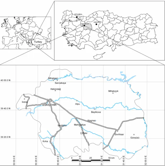
Fig. 1. Location of the study area.
2 Location and geology
Eskis¸ehir is an industrialized city located in the western part of Central Anatolia Region which has a population exceeding 600 thousand habitants and covers an area of approximately 13 700 km2. The (geographical) coordinates of Eskis¸ehir city center are 30◦30′E longitude and 39◦46′N latitude (Fig. 1). Due to its geographical position it is the transportation center between the western and eastern parts of the country. It is also the economical center for mechanical industry.
The geological units are not complex in the province of Eskis¸ehir. Metamorphic, volcanic and sedimentary rocks from Triassic to Quaternary age are the main geological units in the region. The generalized geological map of the city and surroundings is shown in Fig. 2. The oldest units in the North of the study area are grouped into tectonic units consisted of Triassic-aged Eskis¸ehir Metamorphics, Karkın Formation and ophiolitic rocks. Lower Eocene-aged Ma-muca Formation, Upper Miocene-aged Porsuk Formation and Pliocene-aged Ilıca Formation overlie the older units.
The youngest units in the study area could be separated into two units; Pleistocene aged Akc¸ay Formation and recent Al-luvium (G¨ozler et al., 1996).
3 Seismotectonics of the study area
Eskis¸ehir is situated within the second degree earthquake re-gion on the seismic hazard zonation map of Turkey published by the Ministry of Reconstruction and Settlement (1996). The seismotectonics of the study area was reevaluated using earthquake records collected by the National Disaster Orga-nization, and the map of active faults of Turkey constructed by S¸aroˇglu et al. (1992).
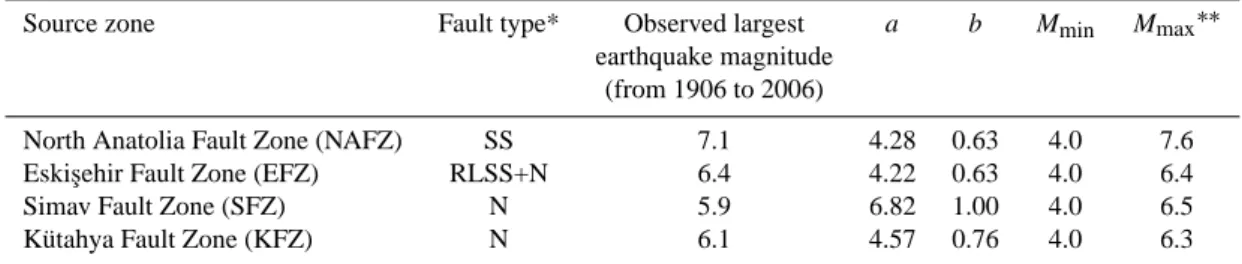
As a result of the detailed seismological survey, four seis-mic sources were delineated in order to determine the seisseis-mic hazard in the city area. These are North Anatolian fault zone (NAFZ), Eskis¸ehir fault zone (EFZ), K¨utahya fault zone (KFZ) and Simav fault zone (SFZ) (Fig. 3). Each fault zone is described in detail below.
ş
Fig. 2. Generalized geological map of Eskis¸ehir and its vicinity (Orhan, 2005).
Fig. 3. Seismic sources and earthquakes occurred during the last 100 years.
The well known NAFZ is a strike-slip fault with a total length of 1400 km and it is divided into two branches in the Marmara Sea Region; only the southern branch was taken into account for this study. Numerous large earthquakes oc-curred both in recent and historical time. For the study area, one of the most important earthquakes is 1957 Abant
earth-quake occurred on this segment with a magnitude of 7.1. Ambraseys (1988) reported that the earthquake was associ-ated with a faulting extending from Northeast of Lake Abant to near Dokurc¸un area.
The WNW-ESE orientated Eskis¸ehir fault zone which sep-arates the Aegean-western Anatolian block from the central
610 A. Orhan et al.: Probabilistic approach for earthquake hazard assessment
Table 1. Seismic hazard parameters used in this study.
Source zone Fault type* Observed largest a b Mmin Mmax∗∗
earthquake magnitude (from 1906 to 2006)
North Anatolia Fault Zone (NAFZ) SS 7.1 4.28 0.63 4.0 7.6
Eskis¸ehir Fault Zone (EFZ) RLSS+N 6.4 4.22 0.63 4.0 6.4
Simav Fault Zone (SFZ) N 5.9 6.82 1.00 4.0 6.5
K¨utahya Fault Zone (KFZ) N 6.1 4.57 0.76 4.0 6.3
* SS: Strike slip fault, RLSS: Right lateral strike slip fault, N: Normal fault ∗∗From Ulusay et al. (2004)
Table 2. Coefficients of attenuation equation by Boore et al. (1997).
Index b1SS b1RV b1ALL b2 b3 b5 bv VA(m/s) h (km) PGA (g) −0.313 −0.117 −0.242 0.527 0.000 −0.778 −0.371 1396 5.57
Table 3. Coefficients of attenuation equation by G¨ulkan and Kalkan (2002).
Index b1 b2 b3 b5 bv VA(m/s) h (km)
PGA (g) −0.682 0.253 0.036 −0.562 −0.297 1381 4.48
Anatolian block is a right lateral strike-slip fault zone with a normal component. The fault zone is characterized by fault segments which trend from E-W to NW-SE around Eskis¸ehir. The largest earthquake occurred on Eskis¸ehir fault zone is the February 1956 earthquake with a magnitude of Ms=6.4. Fault plane solution of the 1956 earthquake and field ob-servations indicate that the EFZ which played an important role in the development of Eskis¸ehir and ˙In¨on¨u plains is a transtensional fault zone (Altunel and Barka, 1998).
K¨utahya Fault Zone is situated at the Southwest of Eskis¸ehir. It is composed of three main segments and each segment could be a major threat for Eskis¸ehir. One of the most important earthquakes recorded around this fault was 1970 C¸ avdarhisar earthquake of magnitude 5.9, with a focal depth of 18 km (Genc¸, 2004).
Simav is one of the graben systems of the Western Anato-lia, which is mainly controlled by the extensional neotectonic regime of the Aegean Region of Turkey. Simav fault trends nearly WNW-ESE for 100 km, along the Simav River from Sindirgi at the West to Muratdagi at the East. The fault is not a single fracture; instead it consists of several step faults parallel to the main fracture (Oyg¨ur, 1997).
4 Results of the analyses
A probabilistic seismic hazard assessment for the province of Eskis¸ehir is carried out, by implementing the Cornell method (Cornell, 1968). The four stages of this procedure are the characterization of seismic sources zones, estimation of seis-mic hazard parameters, selection of appropriate attenuation relationships, and evaluation of the hazard for the sites of interest. The last stage consists of obtaining the seismic haz-ard curves and seismic hazhaz-ard maps. Each stage will be dis-cussed below.
4.1 Characterization of seismic source zones
In Turkey various seismic source models and active fault maps have been reported previously (e.g. Y¨ucemen, 1982; Erdik et al., 1985; S¸aroˇglu et al., 1992). These seismic-source models have been modified taking advantage of re-cent neotectonic and seismic data for Turkey. The previous studies performed by several researchers cover all country. However, large scaled areas were taken into account to ob-tain a database for analysis procedures by DAMHA soft-ware. The data on historical and instrumentally recorded earthquakes for Turkey and surrounding vicinity, collected from the Earthquake Research Department of the General Directorate of Disaster Affairs of Turkey (ERD, 2006) are considered as a basis of seismic hazard calculations. The
Fig. 4. Seismic hazard from all source zones for rock site based on Boore et al. (1997) attenuation relationship (475-year return period).
Fig. 5. Seismic hazard from all source zones for rock site based on G¨ulkan and Kalkan (2002) attenuation relationship (475-year return
period).
earthquakes of magnitudes greater than 4.0 are included in the analyses. Four seismic sources are selected to assess the seismic hazard of Eskis¸ehir. These are NAFZ, EFZ, KFZ, SFZ and are illustrated in Fig. 3.
4.2 Determination of seismic hazard parameters
One of the most important variables of source seismicity is the size (magnitude) of the maximum earthquake. The gen-eral assumption is that 1/3 to 1/2 of the total length of fault would rupture when it generates the maximum earthquake
612 A. Orhan et al.: Probabilistic approach for earthquake hazard assessment
ş
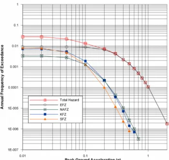
Fig. 6. Hazard contribution by source based on G¨ulkan and Kalkan
(2002) attenuation relationship for Eskis¸ehir city center.
(Mark, 1977). In this study, for each source the maximum earthquake magnitude is determined using the empirical re-lationships proposed by Wells and Coppershmith (1994) as follows:
Mw =5.16 + 1.12 log L (for strike slip faults) (1)
Mw =4.86 + 1.32 log L (for normal faults) (2) Where Mw is moment magnitude of an earthquake and L is fault rupture length in km.
Once the maximum earthquake magnitude is determined for each seismic source, a linear regression is performed to estimate the coefficients of Gutenberg-Richter (1944) rela-tionship using the computer program DAMHA, which is de-veloped for deterministic and probabilistic seismic hazard analyses by Earthquake Research Center of Eskis¸ehir Os-mangazi University (Table 1). In Turkish earthquake cata-logue, the records which have a magnitude equal to or greater than 4.0 is more credible. The Turkish Specification suggests that the data defined above should be used for seismic studies of large engineering structures. The coefficients of the G-R law between magnitudes and their cumulative frequencies of occurrence are as follows:
LogNm=a − bM (3)
where Nm is the number of earthquakes in a given period having magnitude greater than or equal to M, a and b are regression coefficients.
4.3 Selection of appropriate attenuation relationship Due to unavailability of enough strong ground motion records for Eskis¸ehir region, various attenuation relation-ships are considered (Campbell, 1981; Joyner and Boore, 1981; Boore et al., 1993, 1997; Campbell and Bozorgnia, 1994; Ambraseys, 1995; G¨ulkan and Kalkan, 2002). But only Boore et al. (1997) and G¨ulkan and Kalkan (2002) re-lationships are adopted for this study due to the similari-ties between the mechanisms of San Andreas Fault and NAF originated earthquakes. These equations give more realis-tic results. Because the seismic hazard level for Eskis¸ehir by using these both relationships is compatible with differ-ent researches for Turkey and neighboring regions (Erdik et al., 1985, 1999; Ministry of Reconstruction and Settlement, 1996).
The ground motion estimation equation of Boore et al. (1997) is: ln Y =b1+b2(M−6)+b3(M−6)2+b5ln r+bvln Vs VA (4) r =qrj b2 +h2 (5) b1=
b1SS for strike slip earthquakes b1RV for reverse slip earthquakes b1ALL if mechanism is not specified
(6)
Y is the ground motion parameter (peak horizontal acceler-ation or pseudo-acceleracceler-ation response in g); M is moment magnitude; rj bis the Joyner-Boore distance (km); h is a fic-titious depth that was determined by the regression; Vsis the average shear wave velocity to 30.0 m (m/s) and the other coefficients are presented in Table 2.
Since the general form and definitions of the variables and coefficients of G¨ulkan and Kalkan (2002) equation is sim-ilar with Eqs. (4–5) it is not needed to present these equa-tions separately. Other relevant coefficients of the equation are given in Table 3.
4.4 Evaluation of the hazard
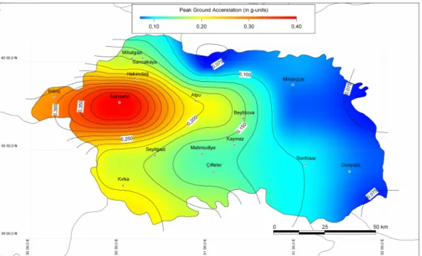
In order to determine the level of seismic hazard at the se-lected sites for Eskis¸ehir city, a probabilistic seismic haz-ard methodology is applied and annual frequencies of ex-ceedance for a number of ground motion levels are calcu-lated with a program DAMHA. The seismic hazard curves for rock site have been developed by selected attenuation re-lationships. After the estimation of maximum acceleration level (10 percent probability of exceedance in 50-years-475 years return period), the seismic hazard maps are created. Figure 4 shows the seismic hazard map obtained using the attenuation relationship of Boore et al. (1997) for 475-year return period. Figure 5 represents the hazard map carried out on the basis of G¨ulkan and Kalkan (2002) relationship.
It came out from this study that the hazard for Eskis¸ehir city center is mainly dominated by Eskis¸ehir fault zone; in decreasing order, the North Anatolian, K¨utahya, and Gediz Fault Zones dominate the hazard (Fig. 6).
5 Conclusions
As based on the probabilistic seismic hazard analysis, the following conclusions are drawn:
1. The attenuation models introduced by Boore et al. (1997) and G¨ulkan and Kalkan (2002) gives more realistic solutions for Eskis¸ehir city and its vicinity. 2. For the province of Eskis¸ehir, the hazard is mainly
dom-inated by Eskis¸ehir fault zone.
3. The analyses indicate that the mean PGA value for the city center of Eskis¸ehir is about 0.40 g with 10 percent probability of exceedance in 50-years. The seismic haz-ard maps produced by this study agree with the one pre-pared by National Disaster Organization for the whole country, but it introduces more detail values for the in-vestigated region.
Edited by: P. F. Biagi
Reviewed by: L. A. Ardeleanu and G. Leydecker
References
Altunel, E. and Barka, A.: Neotectonic activity of Eskis¸ehir fault zone between ˙In¨on¨u and Sultandere, Geological Bulletin of Turkey, 41-2, 41–52, 1998 (in Turkish).
Ambraseys, N. N.: Engineering seismology, Earthquake Engineer-ing and Structural Dynamics, 17, 1–105, 1988.
Ambraseys, N. N.: The prediction of earthquake peak ground ac-celeration in Europe, Earthquake Engineering and Structural Dy-namics, 24, 467–490, 1995.
Ardeleanu, L., Leydecker, G., Bonjer, K.-P., Busche, H., Kaiser D., and Schmitt, T.: Probabilistic seismic hazard map for Romania as a basis for a new building code, Nat. Hazards Earth Syst. Sci., 5, 679–684, 2005,
http://www.nat-hazards-earth-syst-sci.net/5/679/2005/.
Boore, D. M., Joyner, W. B., and Fumal, T. E.: Estimation of re-sponse spectra and peak accelerations from western North Amer-ican earthquakes: An interim report, U.S. Geol. Surv. Open-File Rept., 93–509, 72 p., 1993.
Boore, D. M., Joyner, W. B., and Fumal, T. E.: Equations for esti-mating horizontal response spectra and peak acceleration from Western North American earthquakes: A summary of recent work, Seismol. Res. Lett., 68, 128–153, 1997.
Campbell, K. W.: Near-source attenuation of peak horizontal accel-eration, Bul. Seism. Soc. Am., 71(6), 2039–2070, 1981. Campbell, K. W. and Bozorgnia, Y.: Near-source attenuation
of peak horizontal acceleration from worldwide accelerograms recorded from 1957 to 1993, Proc. Fifth U.S. National Confer-ence on Earthquake Engineering, 3, Chicago, Illinois, 10–14 July 1994, 283–292, 1994.
Chandler, A. M., Chan, L. S., and Lam, N. T. K.: Deterministic seismic hazard parameters and engineering risk implications for Hong Kong region, J. Asian Earth Sci., 20, 59–72, 2001. Cornell, C. A.: Engineering seismic risk analysis, Bull. Seis. Soc.
Am., 58, 1583–1606, 1968.
ERD (Earthquake Research Dept. of Turkey): http://www.sismo. deprem.gov.tr, 2006.
Erdik, M., Doyuran, V., G¨ulkan, P., and Akkas¸, N.: Evaluation of earthquake hazard in Turkey with statistical approach. Mid-dle East Technical University Earthquake Engineering Research Center, Ankara, 116 pp., 1985 (in Turkish).
Genc¸, G.: Probabilistic seismic hazard assessment for Eskis¸ehir, METU, Graduate School of Natural and Applied Sciences, Mas-ter thesis, 154 p., 2004.
G¨ozler, Z., Cevher, F., Erg¨ul, E., and Asutay, H. J.: The geology of middle Sakarya and its south, General Directorate of Mineral Research and Exploration Rep., 9973, 87 pp., 1996 (in Turkish). Gutenberg, B. and Richter, C. F.: Frequency of earhquakes in
Cali-fornia, Bull. Seism. Soc. Am., 34, 185–188, 1944.
G¨ulkan, P. and Kalkan, E.: Attenuation modeling of recent earth-quakes in Turkey, J. Seismol., 6(3), 397–409, 2002.
Joyner, W. B. and Boore, D. M.: Peak horizontal acceleration and velocity from strong-motion records including records from the 1978 Imperial Valley, California earthquake, Bull. Seism. Soc. Am., 71, 2011–2038, 1981.
Kayabalı, K.: Modeling of seismic hazard for Turkey using the re-cent neotectonic data, Eng. Geology, 63, 221–232, 2002. Kramer, S. L.: Geotechnical Earthquake Engineering, Prentice Hall,
New Jersey, 653 pp., 1996.
Mark, R. K.: Application of linear statistical models of earthquake magnitude versus fault length in estimating maximum expectable earthquakes, Geology, 5, 464–466, 1977.
Mapinfo: Mapinfo professional ver. 8.0 user guide, Mapinfo Cor-poration, Troy, New York, 788 pp., 2005.
McGuire, R. K.: Deterministic vs. probabilistic earthquake hazards and risks, Soil Dynam. Earthquake Eng., 21, 377–384, 2001. Ministry of Reconstruction and Settlement: Seismic Hazard Map of
Turkey, 1996.
Nakajima, M., Choi, I., Ohtori, Y., and Choun, Y.: Evaluation of seismic hazard curves and scenario earthquakes for Korean sites based on probabilistic seismic hazard analysis, Nucl. Eng. Des., 237, 277–288, 2007.
Orhan, A.: The geo-engineering properties of foundation soils in southern part of Eskis¸ehir city center and applying of geographic information system, Eskis¸ehir Osmangazi Univertsity, Graduate School of Natural and Applied Sciences, Ph.D. thesis, 125 pp., 2005 (in Turkish).
Oyg¨ur, V.:, Metallogeny of the Simav Graben (Inner- Western Ana-tolia, Turkey), METU, Graduate School of Natural and Applied Sciences, Ph.D thesis, 144 pp., 1997.
Simeonova S. D., Solakov, D. E., Leydecker, G., Busche, H., Schmitt, T., and Kaiser, D.: Probabilistic seismic hazard map for Bulgaria as a basis for a new building code, Nat. Hazards Earth Syst. Sci., 6, 881–887, 2006,
http://www.nat-hazards-earth-syst-sci.net/6/881/2006/.
S¸aroˇglu, F., Emre, ¨O., and Kus¸cu, ˙I.: Active Fault Map of Turkey, General Directorate of Mineral Research and Explo-ration, Ankara, 1992.
614 A. Orhan et al.: Probabilistic approach for earthquake hazard assessment M.: Seismic Hazard and Total Risk Analyses for Large Dams
in Euphrates Basin, Turkey, Engineering Geology, 89, 155–170, 2007.
Ulusay, R., Tuncay, E., S¨onmez, H., and G¨okc¸eoˇglu, C.: An atten-uation relationship based on Turkish strong motion data and iso-acceleration map of Turkey, Eng. Geology, 74(3–4), 265–291, 2004.
Y¨ucemen, S.: Seismic risk analysis, Middle East Technical Univer-sity, Ankara, 160 pp., 1982 (in Turkish).
Wells, D. L. and Coppersmith, K. J.: New emprical relationships among magnitude, rupture length, rupture width, rupture area, and surface displacement, B. Seism. Soc. Am., 84(4), 974–1002, 1994.