HAL Id: hal-00298952
https://hal.archives-ouvertes.fr/hal-00298952
Submitted on 4 Jun 2008HAL is a multi-disciplinary open access
archive for the deposit and dissemination of sci-entific research documents, whether they are pub-lished or not. The documents may come from teaching and research institutions in France or abroad, or from public or private research centers.
L’archive ouverte pluridisciplinaire HAL, est destinée au dépôt et à la diffusion de documents scientifiques de niveau recherche, publiés ou non, émanant des établissements d’enseignement et de recherche français ou étrangers, des laboratoires publics ou privés.
Storage and transport in cave seepage- and groundwater
in a South German karst system
K. Schwarz, J. A. C. Barth, P. Grathwohl, C. Postigo-Rebello
To cite this version:
K. Schwarz, J. A. C. Barth, P. Grathwohl, C. Postigo-Rebello. Storage and transport in cave seepage-and groundwater in a South German karst system. Hydrology seepage-and Earth System Sciences Discussions, European Geosciences Union, 2008, 5 (3), pp.1267-1287. �hal-00298952�
HESSD
5, 1267–1287, 2008 Storage and transport in cave seepage K. Schwarz et al. Title Page Abstract Introduction Conclusions References Tables Figures ◭ ◮ ◭ ◮ Back CloseFull Screen / Esc
Printer-friendly Version Interactive Discussion
Hydrol. Earth Syst. Sci. Discuss., 5, 1267–1287, 2008 www.hydrol-earth-syst-sci-discuss.net/5/1267/2008/ © Author(s) 2008. This work is distributed under the Creative Commons Attribution 3.0 License.
Hydrology and Earth System Sciences Discussions
Papers published in Hydrology and Earth System Sciences Discussions are under open-access review for the journal Hydrology and Earth System Sciences
Storage and transport in cave
seepage-and groundwater in a South German karst
system
K. Schwarz1, J. A. C. Barth1,2, P. Grathwohl1, and C. Postigo-Rebello3
1
Eberhard Karls University of T ¨ubingen, Center for Applied Geoscience, Sigwartstr. 10, 72076 T ¨ubingen, Germany
2
Lehrstuhl f ¨ur Angewandte Geologie der Friedrich-Alexander-Universit ¨at Erlangen-N ¨urnberg, Schloßgarten 5, 91054 Erlangen, Germany
3
Consejo Superiour de Invstigationes Cientificas, Jordi Girona 18–26, 8034 Barcelona, Spain Received: 17 April 2008 – Accepted: 6 May 2008 – Published: 4 June 2008
Correspondence to: J. A. C. Barth (johannes.barth@uni-tuebingen.de)
HESSD
5, 1267–1287, 2008 Storage and transport in cave seepage K. Schwarz et al. Title Page Abstract Introduction Conclusions References Tables Figures ◭ ◮ ◭ ◮ Back CloseFull Screen / Esc
Printer-friendly Version Interactive Discussion
Abstract
We investigated one of the best-known and second largest karst areas in Germany (Blautopf Catchment) that offers a unique access waters of the unsaturated zone through a large cave system. As tracers for water flow and storage we measured stable isotopes (18O/16O and D/H ratios) in precipitation, seepage- and groundwater.
5
The precipitation showed a distinct seasonal cycle with δ18O values between −2.6 and −22.6‰ during summer and winter, respectively. However, the isotope signals in seepage water in the caves as well as the discharge were completely buffered and ranged around an average δ18O value of −10‰. This value also matched the long-term average of the precipitation. In addition, the homogeneous isotopic composition
10
of the Blautopf Spring was against expectation for its highly variable discharge (0.3 to 32 m3s−1) that is typical for a fast responsive karst system. We explain the iso-topic similarity between cave seepage and the Blautopf Spring (as an integral signal for groundwater) by nearly complete mixing of the water already in the vadose zone. The latter can be divided into the compartments soil, epikarst and rock matrix that all
15
have good storage capacities and also allow diffusive exchange of solutes between mobile and less mobile matrix water. The above approach revealed new aspects about turnover and flow paths of the infiltrated water and thus helps to constrain the risk by pollution to the groundwater.
1 Introduction
20
Understanding of water pathways and movements in the vadose and phreatic zones is a prerequisite for evaluation of the risk for groundwater pollution. In karst areas such evaluations become particularly important as about 25% of the world’s population rely on karst sources for potable water supply (Ford and Williams, 1989). A brief classifica-tion to karst systems is summarised by Cruz et al. (2005), Genty and Deflande (1998),
25
HESSD
5, 1267–1287, 2008 Storage and transport in cave seepage K. Schwarz et al. Title Page Abstract Introduction Conclusions References Tables Figures ◭ ◮ ◭ ◮ Back CloseFull Screen / Esc
Printer-friendly Version Interactive Discussion
1. the non-karst recharge area consisting of soils or non carbonaceous bedrock 2. the epikarst and
3. the saturated zone.
Particularly the influence of the epikarst was recently investigated in more detail as it is assumed to play a major role in mixing and mobilising of waters (Sauter, 1995; Aquilina
5
et al., 2006; Perrin et al., 2003; Clemens et al., 1999). According to Mangin (1973), epikarst is a perched saturated zone above the groundwater table that stores part of the infiltrated water. To describe the variable flow character of karst systems, it also is necessary to consider the conduits that are embedded in the fissured-porous matrix (Liedl and Sauter, 1998, 2000; Kiraly, 1998).
10
Tracer tests are useful tools particularly for investigation of flow dynamics in karst systems. Such tests with salts or dyes were previously carried out in the Blautopf Catchment for instance in sinkholes. They were able to reveal information about the fast conduit system. However, the latter usually presents only a small part of the subsurface water balance (Bauer and Selg, 2006). Therefore more widely distributed tracers such
15
as stable isotopes are needed to help assess risks from diffuse pollution for the total catchment. This works, if stable isotope changes in space are homogeneous and altitude effects (Clark and Fritz, 1997) can be assumed to be minor. If so, isotope signals in precipitation can be thought to give the same input signal for areas of several hundred square kilometres such as the Blautopf Catchment. Water stable isotopes
20
can therefore help to draw conclusions about the hydrodynamic parameters of the total karstic-fissured-porous system.
Specifically, 18O/16O and/or D/H ratios are suitable tools because they are con-stituents of water molecules and thus act as ubiquitous conservative tracers (Mal-oszewski et al., 2002).
25
In this study the main focus was on the overall diffuse recharge and transport pro-cesses in a karst system at the catchment scale. The objective was to determine the relevance and mixing behaviour of the entire system rather than focussing on the
HESSD
5, 1267–1287, 2008 Storage and transport in cave seepage K. Schwarz et al. Title Page Abstract Introduction Conclusions References Tables Figures ◭ ◮ ◭ ◮ Back CloseFull Screen / Esc
Printer-friendly Version Interactive Discussion
fast flow paths of the infiltrated water. In our approach, comparison between the iso-topic composition of precipitation and discharge allowed to decide if mixing occurs in such a fast responsive system or if precipitation reaches the spring relatively unaltered. Furthermore, with caves being present in a well-developed unsaturated zone of up to 150 m thickness, we were also able to narrow down where mixing occurs and how
5
much of this process is restricted to this zone that lies at the receiving end of the flow path.
The setting of the Blautopf Catchment with its caves enabled convenient sampling of the unsaturated and saturated zone and therefore was ideal to provide new insights how these compartments are linked. Such information is fundamental for
understand-10
ing subsurface water movement. It may also help to evaluate the risk of groundwater contamination caused mainly by diffuse pollution and can give important insights to water balances and ultimately contaminant transport.
2 Materials and methods
2.1 Sampling sites
15
The Blautopf Catchment is situated on the “Schw ¨abische Alb” (Fig. 1), which together with the “Fr ¨ankische Alb” makes up the largest karst area in Germany (Villinger, 1997). The catchment area is rural and has a size of 165 km2 of which ∼31% is covered by forests while more than 60% agricultural land (K ¨oberle, 2005).
The Blautopf Catchment has more than 50 caves. We have chosen three of them
20
for our investigation (Fig. 1). They are called “Laichinger Tiefenh ¨ohle” (LTH) and “Son-theimer H ¨ohle” (SH) that are public show-caves and the “Hawaii-Schacht” (HWS) that is not accessible to the general public.
The Schw ¨abische Alb has a typical continental climate with an annual average temperature of 6.5◦C (1961 to 1990) (M ¨uller-Westermeier et al., 1999). The aver-25
HESSD
5, 1267–1287, 2008 Storage and transport in cave seepage K. Schwarz et al. Title Page Abstract Introduction Conclusions References Tables Figures ◭ ◮ ◭ ◮ Back CloseFull Screen / Esc
Printer-friendly Version Interactive Discussion
1100 mm a−1 and decreases towards the south-eastern part to average values of 800 mm a−1 (Keller, 2003). The mean groundwater recharge in the Blautopf Catch-ment is about 500 mm a−1 (Armbruster, 2002). The mean discharge of the Blautopf
spring – the principal outlet of the system – was determined with 2.43 m3s−1 between 1980 and 2003. However, it shows considerable variability with the highest discharge
5
of close to 32 m3s−1and the lowest of 0.3 m3s−1. The Blautopf Spring responds within
several days to extreme precipitation events and snow melts. This indicates a strong karstification of large parts of the aquifer that is mostly composed of the fissured Kim-meridge and Tithon Limestones of the upper Jurasic (Villinger, 1987).
In average the soil cover is about 50 cm and the main soil type is a rendzic
lep-10
tosol. Underneath this soil cover, the thickness of the vadose zone varies between 100 and 150 m. The thickness of the saturated zone was not determined precisely in this study, but is estimated to range between 50 and 120 m (Postigo-Rebello, 20061). A comprehensive overview of the hydrology of the Blautopf Catchment is described in Villinger (1978). Upstream of the Blautopf spring, a large cave system with phreatic
15
and vadose zones has been explored up to a length of around 4 km from the spring (www.blautopf.org).
2.2 Stable isotope sampling and analyses
Samples for stable isotope analyses were collected in the caves and the Blautopf Spring between February 2005 and July 2006. In the same time period precipitation
20
was collected with the aim to sample most precipitation events of this period includ-ing long-term snowfall and thunderstorms. A commercially available rain collector was placed at the village of Heroldstatt (9◦40′01′′E, 48◦26′39′′N; altitude ∼780 m above sea level). After each sampling event, samples were transferred into 20-mL vials with
1
Postigo-Rebello, C.: Effects of plant transpiration on water and carbon cycling in the blau-topf catchment (south-west germany), Zentrum f ¨ur Angewandte Geowissenschaften (ZAG), Universit ¨at T ¨ubingen, unpublished, T ¨ubingen, 82 pp., 2006.
HESSD
5, 1267–1287, 2008 Storage and transport in cave seepage K. Schwarz et al. Title Page Abstract Introduction Conclusions References Tables Figures ◭ ◮ ◭ ◮ Back CloseFull Screen / Esc
Printer-friendly Version Interactive Discussion
tight screw caps to avoid secondary evaporation effects. Afterwards they were stored upside down at 4◦C in the dark.
The cave seepage waters were collected at three different locations HWS, LTH and SH (Fig. 1). In the LTH three sampling locations with different distances to the surface were chosen to investigate a variety of possible flow paths and residence times. They
5
were the “Vesperhalle” (VH), “Nasser Schacht” (NS) and “S ¨achsische Schweiz” (TK). Exact locations of these sampling sites are displayed in Fig. 2. The seepage water was collected with a vial, the filling time of which took several minutes in winter and up to half an hour in summer. The discharge water was collected in the Blautopf Spring from a depth of 20 cm below the surface and a few meters before the outflow. At this
10
location a constant flow ensured supply of freshly discharged water.
Overall, 69 samples were measured for precipitation, 26 for the spring and a sum of 139 for all cave seepage waters. For some selected samples the hydrogen values were measured and allowed establishing a local meteoric water line (Postigo-Rebello, 2006).
15
2.3 Analyses
Stable isotopes ratios of the water were measured at the department for Geochemistry at the Centre for Applied Geosciences (ZAG). A Thermo-Finnigan isotope ratio mass spectrometer (IRMS, Model MAT 252) was used to determine the 18O/16O and D/H ratios after equilibration with CO2 and by combustion to H2 gas, respectively. Both 20
parameters were calculated with respect to the international standard VSMOW (Vienna Standard Mean Ocean Water) using the following equation:
δsample=
" Rsample− RVSMOW
RVSMOW
#
· 1000 (1)
where R is the ratio18O/16O or D/H. The one σ satandard deviation for repeat measure-ments was ±0.2‰ for δ18O and ±1 for δD. The weighted mean isotopic composition
HESSD
5, 1267–1287, 2008 Storage and transport in cave seepage K. Schwarz et al. Title Page Abstract Introduction Conclusions References Tables Figures ◭ ◮ ◭ ◮ Back CloseFull Screen / Esc
Printer-friendly Version Interactive Discussion
for the precipitation was calculated with:
Cw = P QtCt
P Qt (2)
where Qt is the rain amount [L m−2] and Ct the δ
18
O signal of the precipitation water at time t.
2.4 Climatic data
5
Data for precipitation were provided by the sewage plant in Heroldstatt (9◦40′42′′E, 48◦26′30′′N) that has an altitude of 728 m above sea level and is located 0.6 km away from the precipitation sampling station for isotopes. A Hellmann apparatus was used to determine the precipitation amounts. It was emptied every morning and the maximum and minimum temperatures were also recorded each day. The amount of snow was
10
established by melting.
The discharge at the Blautopf Spring was continuously recorded by the Lan-desanstalt f ¨ur Umwelt, Messungen und Naturschutz Baden-W ¨urttemberg (Karlsruhe).
3 Results and discussion
3.1 Input of the isotope signal
15
The δ18O data for precipitation varied between −2.6 and −22.6‰ and between −15 and −125‰ for δD. The weighted mean concentration for δ18O in the period from May 2005 to April 2006 was determined with −9.4‰ (n=11, January is missing). Figure 3 shows the isotopic variability of the rainfall. For comparison, Bauer and Selg (2006) determined a weighted mean average of δ18O of −9.5‰ at the station M ¨unsingen that
20
is at a distance of 15 km from Heroldstatt. Our δ18O values showed clear season-ality patterns with maximum values in summer and minimum values in winter. With
HESSD
5, 1267–1287, 2008 Storage and transport in cave seepage K. Schwarz et al. Title Page Abstract Introduction Conclusions References Tables Figures ◭ ◮ ◭ ◮ Back CloseFull Screen / Esc
Printer-friendly Version Interactive Discussion
lateral distribution patterns of δ18O in the catchment being relative homogeneous and assuming relatively small altitude effects one sampling point can be used to represent the isotopic input for the entire catchment.
3.2 Local meteoric water line
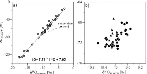
When plotting the δ18O and δD values of the precipitation, a linear relationship is
5
established that is typical for the area (Fig. 4). It is known as the local meteoric water line and was established for the Blautopf Catchment by Postigo-Rebollo (2006). The isotopic values of seepage and Blautopf discharge samples all fell on this line (Fig. 4). This indicates negligible effects of evaporation near the surface, or during transit from the surface to the cave that can be a concern during warm conditions (Cruz Jr et
10
al., 2005). However, in temperate zones such as in the Blautopf area, this effect is negligible and our findings show that the local precipitation is indeed responsible for the recharge of the spring without any alteration of the isotope signal.
3.3 Isotope signal of the seepage and spring water
The samples of the seepage and the spring water did only vary in a narrow range
15
(Figs. 3 and 4). They showed oxygen values between −9.5 and −10.6‰ (LTH). Corre-sponding to this, the δD values ranged between −70 and −73‰ for the LTH and −67 and −72‰ for the Blautopf (data listed in Table 1). The other locations in the caves showed very similar results with δ18O values ranging from −9.3 to −10.5‰, −9.2 to −10.6‰, −9.4 to −9.9‰ and −9.5 to −10.6‰ for VH, NS, SH and HWS, respectively.
20
Location NS is known for a fast response to strong precipitation events, however even at this subsurface location no strong seasonality in the δ18O signal was found. Nordhoff (2005) measured δ18O values in the “Zaininger H ¨ohle” that is also located in the Blau-topf Catchment and found similar δ18O values in the drip water (−10.5 to −11.2‰). This similarity between cave seepage waters already indicates that a significant
ho-25
HESSD
5, 1267–1287, 2008 Storage and transport in cave seepage K. Schwarz et al. Title Page Abstract Introduction Conclusions References Tables Figures ◭ ◮ ◭ ◮ Back CloseFull Screen / Esc
Printer-friendly Version Interactive Discussion
of flow path.
Furthermore, the similarity of spring discharge and cave seepage waters show that the isotopic variability from the precipitation must already be buffered in the unsaturated zone above the caves. This is also confirmed by the cave seepage water representing almost the weighted mean δ18O value of the precipitation that was calculated with a
5
value of −9.4‰. In other words, the variability of the annual isotopic variation of the precipitation was hardly found in the cave drip water. Even with the monthly average values for the drip water, we only found insignificant changes towards the more neg-ative winter values. Similarly heavy rain events during summer only produced slight isotopic increases in the drip water of caves. Even the base flow measured at the
10
Blautopf Spring and the weighted average of the precipitation water (weighted over the sampling period of more than a year) showed very similar and homogeneous isotope signals. The isotope values of the Blautopf Spring in this study confirmed the results found by Bauer and Selg (2006), who determined values between −9.7 and −10.2‰ for the Blautopf discharge. This also conforms to other findings where similar buffering
15
of the isotope signal of the precipitation was found in other karst areas in Israel, Spain, Switzerland and USA (Aaylon et al., 1998; Yonge et al., 1985; Caballero et al., 1996; Perrin et al., 2003).
Cruz et al. (2005) stated that the dynamics of karst seepage flow are largely influ-enced by storage capacity. They also found that the drip discharge is often delayed
20
in time depending on thickness and character of the unsaturated zone. This nicely fits our results and supports the fact that the main mixing and storage processes to occur in the upper part of the unsaturated zone. Hydrochemical and isotope studies from various regions (Arabika Massif, New Zealand and New Mexico) demonstrate that a delay in flow caused by storage in the epikarst can range from several days to a few
25
months (Williams, 1983; Klimchouk and Jablokova, 1989). On the other hand, sea-sonal variations of δ18O were found to be significantly reduced after about 3.5 years of residence time in the soil and epikarst zone in the neighbouring Fr ¨ankische Alb (Stich-ler and Herrmann, 1983). With the current data set we are not able to determine exact
HESSD
5, 1267–1287, 2008 Storage and transport in cave seepage K. Schwarz et al. Title Page Abstract Introduction Conclusions References Tables Figures ◭ ◮ ◭ ◮ Back CloseFull Screen / Esc
Printer-friendly Version Interactive Discussion
travel times of water. Nonetheless, the above research findings provide the boundary conditions for residence times of water in the unsaturated zone.
Einsiedl (2005) and Einsiedl and Mayer (2005) established that the fissured-porous aquifer, especially the rock matrix, is the main water storage, whereas the soil and the epikarst have only a low storage capacity. However, Perrin (2003) stipulated that the
5
soil and the epikarst subsystems appear to act as an important storage element of the karst system. With the current data set, a differentiation between these compartments is not possible. However, given the thickness of the vadose zone of the Blautopf Catch-ment (in average 100–150 m) a considerable storage can be assumed for the epikarst. In any case, the homogenisation of the isotopic composition seems to take place close
10
to the surface. This is confirmed by other workers who found a good match between the isotopic composition of the drip and the soil water in Brazil (Cruz Jr et al., 2005).
For the saturated flow, Worthington et al. (2002) estimated hydraulic conductivities for different carbonate aquifers, amongst others one of the Schw ¨abische Alb. They determined average hydraulic conductivities of 8×10⁻⁹m s−1. Associated slow water
15
movement can be considered as storage. The base flow preferentially enables gravi-metrical flow of more easily mobilized water. However, after heavy rain events also smaller fissures become flooded and connected (Fig. 5). In such a case, the hydraulic pressure pushes the pre-event water out of the storage zone towards the larger con-duits in a piston flow effect. In 1974 Mangin already stated that epikarst becomes
sat-20
urated and connected during heavy rain events. The good agreement between cave seepage water and Blautopf discharge also implies that only a minor part of heavy precipitation events bypasses the epikarst and soil zone along preferential flow paths. This confirmed by the fact that high discharge seemed to provoke only a slight change of the isotopic composition in the Blautopf Spring. The proposition that only a small
25
part of the precipitation reaches the discharge directly was also confirmed with mod-elling where the conductive part of the complete discharge was determined with only about 1% (Bauer and Selg, 2006). Nevertheless, during extreme events the conductive discharge during an event can be as high as 5–10% (Bauer and Selg, 2006).
HESSD
5, 1267–1287, 2008 Storage and transport in cave seepage K. Schwarz et al. Title Page Abstract Introduction Conclusions References Tables Figures ◭ ◮ ◭ ◮ Back CloseFull Screen / Esc
Printer-friendly Version Interactive Discussion
An investigation of persistent pollutants (POPs) in the same area produced similar findings with the largest amounts of POPs reaching the saturated zone shortly after high discharge events such as snow melts. This can be explained by the piston flow ef-fect with the increasing pressure from higher precipitation amounts mobilising particles deposited in the fissures of the epikarst. After the fissures are flooded and connected
5
the infiltrated water is able to transport the particles towards the receiving stream. The Blautopf Spring reacts very fast to snow melts and heavy rain events thus confirming it to have a saturated conduit system (Birk et al., 2004).
4 Conclusions
By investigating the karst aquifer of the Blautopf Catchment with water stable isotopes
10
the following conclusions could be drawn:
(i) The variability of the stable isotope signal of the precipitation could not be found in the Blautopf discharge, which was homogeneous throughout the year. This indicates that considerable mixing must take place in the subsurface of the catchment. It also confirms that fast conduit systems play a minor role in the water balance.
15
(ii) The stable isotope signal of the precipitation was already buffered in the vadose zone and the cave seepage water did only show little variability in its isotopic composi-tion that was very similar to the isotope value of the Blautopf Spring (i.e. groundwater) and the weighted averages of the annual precipitation. This is in contrast to the isotope curve of the precipitation and indicates a considerable mixing in the unsaturated zone.
20
(iii) At present it is difficult to decide which compartment in the unsaturated zone is most responsible for mixing the incoming water masses but the most likely candidates are the soil and epikarst compartments.
The mixing of water seemed to be maintained even during high discharge (e.g. after snow melts) because the Blautopf Spring always maintained its homogeneous isotope
25
values. Nonetheless, other investigations showed increased mobilisation of pollutants during such times. This may be explained through involvement of the fine fracture
HESSD
5, 1267–1287, 2008 Storage and transport in cave seepage K. Schwarz et al. Title Page Abstract Introduction Conclusions References Tables Figures ◭ ◮ ◭ ◮ Back CloseFull Screen / Esc
Printer-friendly Version Interactive Discussion
system of the epikarst.
Future work should focus at investigations of the buffer capacity of the soil and epikarst zone and more research should be devoted to the bedrock matrix. Further dynamic tracers such as tritium isotopes could reveal better insight into travelling times of subsurface water masses.
5
Acknowledgements. This project was funded by the Deutsche Forschungsgemeinschaft (DFG;
German Research Foundation) under grants no. GR 971/20-2. We are grateful to the team of Heiner Taubald who did the isotope measurement, to Patrick Thielsch who recorded the weather data and to the Landesanstalt f ¨ur Umwelt, Messungen und Naturschutz Baden-W ¨urttemberg (Karlsruhe) to provide the spring data. This work was also supported by a grant
10
from the Ministry of Science, Research and the Arts of Baden Wuertemberg (AZ33-7533.18-15-02/80) to Johannes Barth and Peter Grathwohl. This work was also supported by the European Integrated Project AquaTerra (GOCE 505428). The project has received research funding from the Community’s Sixth Framework Programme.
References
15
Aaylon, A., Bar-Matthews, M., and Stass, E.: Rainfall-recharge relationships within a karstic terrain in the eastern mediterranean semi-arid region, israel: ∆18o and δd characteristics, J. Hydrol., 207, 18–31, 1998.
Aquilina, L., Ladouche, B., and D ¨orfliger, N.: Water storage and transfer in the epikarst of karstic systems during high flow periods, J. Hydrol., 327, 472–485, 2006.
20
Armbruster, V.: Grundwasserneubildung in Baden-W ¨urttemberg, Freiburger Schriften zur Hy-drologie, 17, 141 pp, 2002.
Bauer, M. and Selg, M.: Altersstruktur und mittlere verweilzeit im grundwasser des blautopfs und anderer quellen und brunnen im oberjura-karst s ¨uddeutschlands, T ¨ubinger Geowis-senschaftliche Arbeiten (TGA), C98, 17–44, 2006.
25
Birk, S., Liedl, R., and Sauter, M.: Identification of localised recharge and conduit flow by combined analysis of hydraulic and physico-chemical spring responses (urenbrunnen, sw-germany), J. Hydrol., 286, 179–193, 2004.
HESSD
5, 1267–1287, 2008 Storage and transport in cave seepage K. Schwarz et al. Title Page Abstract Introduction Conclusions References Tables Figures ◭ ◮ ◭ ◮ Back CloseFull Screen / Esc
Printer-friendly Version Interactive Discussion
Burger, D., Geyh, M. A., Papenfuß, K.-H., Smettan, H., Teichmann, R., and Ufrecht, W.: Sed-imentpetrographie und Alter von H ¨ohlenlehmen aus der Laichinger Tiefenh ¨ohle (7524/01, Schw ¨abische Alb), Laichinger H ¨ohlenfreund, 28, 47–72, 1993.
Caballero, E., Jim ´enez De Cisneros, C., and Reyes, E.: A stable isotope study of cave seepage waters, Appl. Geochem., 11, 583–587, 1996.
5
Clark, I. D. and Fritz, P.: Environmental isotopes in hydrogeology, CRC Press/Lewis Publishers, Boca Raton, 328 pp., 1997.
Clemens, T., H ¨uckinghaus, D., and Liedl, R.: Simulation of the development of karst aquifers: Role of the epikarst, Int. J. of Earth Sci., 88, 157–162, 1999.
Cruz Jr, F. W., Karmann, I., Viana Jr, O., Burns, S. J., Ferrari, J. A., Vuille, M., Sial, A. N., and
10
Moreira, M. Z.: Stable isotope study of cave percolation waters in subtropical brazil: Implica-tions for paleoclimate inferences from speleothems, Chem. Geol., 220, 245–262, 2005. Ford, D. C. and Williams, P. W.: Karst geomorphology and hydrology, Chapman & Hall, London,
601 pp., 1989.
Genty, D. and Deflande, G.: Drip flow variations under a stalactite of the p `ere noel cave
(bel-15
gium): Evidence of seasonal variations and air pressure constraints, J. Hydrol., 211, 208– 232, 1998.
Keller, R.: Hydrologischer atlas von deutschland, edited by: Bundesumweltministerium f ¨ur Umwelt, N. u. R., Bonn/Berlin, 2003.
Kiraly, L.: Modelling karst aquifers by the combined discrete channel and continuum approach,
20
Bulletin d’Hydrog ´eology, 16, 77–98, 1998.
Klimchouk, A. B. and Jablokova, N. L.: Evidence of hydrological significance of the epikarstic zone from study of ogygene isotope composition of water, arabika massif, western caucasus, Proceeding of the 10th International Conference of Speleogenesis, Budapest, 1989, 798– 799,
25
K ¨oberle, G.: Gis-generierte Bodenkarte von Baden-W ¨urttemberg 1: 25000, Blatt 7524 Blaubeuren, Karte mit Erl ¨auterungen, T ¨ubinger Geographische Studien 123, Universit ¨at T ¨ubingen, T ¨ubingen, 2005.
Liedl, R. and Sauter, M.: Modelling of aquifer genesis and heat transport in karst system, Bulletin d’Hydrog ´eology, 16, 185–200, 1998.
30
Liedl, R. and Sauter, M.: Charakterisierung von karstgrundwasserleitern durch simulation der aquifergenese und des w ¨armetransports, Grundwasser, 5, 9–16, 2000.
karstic-HESSD
5, 1267–1287, 2008 Storage and transport in cave seepage K. Schwarz et al. Title Page Abstract Introduction Conclusions References Tables Figures ◭ ◮ ◭ ◮ Back CloseFull Screen / Esc
Printer-friendly Version Interactive Discussion
fissured-porous aquifer, the Schneealpe, Austria, by modelling of environmental18o and3h isotopes, J. Hydrol., 256, 48–59, 2002.
Mangin, A.: Sur la dynamique des transferts en aquif `ere karstique, International Congress on Speleology, Olomouc, 157–162, 1973.
Mangin, A.: Contribution `a l’ ´etude hydrodynamique des aquif `eres karstiques, Annales de
5
Sp ´el ´eologie, 29, 283–332, 1974.
M ¨uller-Westermeier, G., Kreis, A., and Dittmann, E.: Klimaatlas bundesrepublik deutschland (1:2500000), Deutscher Wetterdienst, Offenbach, 1–3, 1999.
Perrin, J., Jeannin, P.-Y., and Zwahlen, F.: Epikarst storage in a karst aquifer: A conceptual model based on isotopic data, milandre test site, switzerland, J. Hydrol., 279, 106–124,
10
2003.
Sauter, M.: Die Rolle des Epikarstes f ¨ur den Stofftransport durch Karstgrundwasserleiter – Quantifizierung des Eintrags und numerische Modellierung, Zeitschrift der Deutschen Geol-ogischen Gesellschaft, 146, 263–273, 1995.
Stichler, W. and Herrmann, A.: Application of environmental isotope techniques in water
bal-15
ance studies of small basins, IAHS Publication, 148, 93–112, 1983.
Villinger, E.: Zur Karsthydrologie des Blautopfs und seines Einzugsgebietes (Schw ¨abische Alb), Abhandlungen des Geologischen Landesamtes Baden-W ¨urttemberg, 8, 59–127, 1978.
Villinger, E.: Die Blautopfh ¨ohle bei Blaubeuren als Beispiel f ¨ur die Entwicklung des
Karstsys-20
tems im Schw ¨abischen Malm, Geologisches Jahrbuch, C49, 71–103, 1987.
Villinger, E.: Der Oberjura-Aquifer der Schw ¨abichen Alb und des Baden-W ¨urttembergischen Molassebeckens (SW-Deutschland), in: Aquifersystem S ¨uddeutschlands – eine Vor-lesungsreihe an der Universit ¨at T ¨ubingen, Edited by: Herbert, M. and Teutsch, G., Lehrstuhl f ¨ur Angewandte Geologie, T ¨ubingen, 77–108, 1997.
25
Williams, P. W.: The role of the subcutaneous zone in karst hydrology, J. Hydrol., 61, 45–67, 1983.
Yonge, C. J., Ford, D. C., Gray, J., and Schwarcz, H. P.: Stable isotope studies of cave seepage water, Chemical Geology, 58, 97–105, 1985.
HESSD
5, 1267–1287, 2008 Storage and transport in cave seepage K. Schwarz et al. Title Page Abstract Introduction Conclusions References Tables Figures ◭ ◮ ◭ ◮ Back CloseFull Screen / Esc
Printer-friendly Version Interactive Discussion
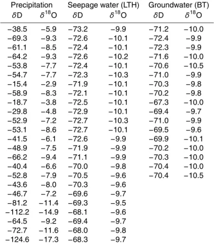
Table 1. Selected isotope values (δ18O and δD) from the precipitation, seepage water of the Laichinger Tiefenh ¨ohle and groundwater (Blautopf Spring).
Precipitation Seepage water (LTH) Groundwater (BT)
δD δ18O δD δ18O δD δ18O −38.5 −5.9 −73.2 −9.9 −71.2 −10.0 −69.3 −9.3 −72.6 −10.1 −72.4 −9.9 −61.1 −8.5 −72.4 −10.1 −72.3 −9.9 −64.2 −9.3 −72.6 −10.2 −71.6 −10.0 −53.8 −7.7 −72.4 −10.1 −70.6 −10.5 −54.7 −7.7 −72.3 −10.3 −71.0 −9.9 −15.4 −2.9 −71.9 −10.1 −70.3 −9.8 −58.9 −8.3 −72.1 −10.1 −70.2 −9.8 −18.7 −3.8 −72.5 −10.1 −67.3 −10.0 −29.8 −4.8 −72.9 −10.1 −69.4 −9.7 −52.9 −7.2 −72.7 −10.3 −71.0 −9.9 −53.1 −8.6 −72.7 −10.1 −69.5 −9.6 −41.5 −6.1 −72.6 −9.9 −69.9 −10.1 −48.9 −7.5 −71.9 −9.9 −70.2 −10.0 −66.2 −9.4 −71.1 −9.9 −70.3 −10.0 −40.4 −6.6 −70.0 −9.8 −70.4 −10.0 −52.8 −7.9 −70.5 −9.6 −70.4 −10.5 −43.6 −8.0 −70.3 −9.6 −46.7 −7.2 −69.6 −9.7 −81.2 −11.4 −69.3 −9.5 −112.2 −14.9 −68.1 −9.6 −64.5 −9.2 −69.4 −9.7 −72.7 −11.6 −68.0 −9.8 −124.6 −17.3 −68.3 −9.7
HESSD
5, 1267–1287, 2008 Storage and transport in cave seepage K. Schwarz et al. Title Page Abstract Introduction Conclusions References Tables Figures ◭ ◮ ◭ ◮ Back CloseFull Screen / Esc
Printer-friendly Version Interactive Discussion
Table 1. Continued.
Precipitation Seepage water (LTH) Groundwater (BT)
δD δ18O δD δ18O δD δ18O −123.5 −16.2 −71.3 −9.9 −74.2 −10.5 −72.1 −10.6 −96.9 −13.5 −71.4 −10.0 −111.0 −15.3 −70.6 −10.0 −125.0 −17.7 −72.6 −9.9 −59.0 −10.0 −71.3 −10.3 −111.4 −16.2 −68.6 −9.3 −51.2 −7.6 −51.8 −7.5 −32.3 −5.7 −125.4 −16.8 −37.5 −5.6 −55.3 −8.4 −37.4 −5.6 −32.5 −5.1 −77.5 −4.6 −31.0 −11.2
HESSD
5, 1267–1287, 2008 Storage and transport in cave seepage K. Schwarz et al. Title Page Abstract Introduction Conclusions References Tables Figures ◭ ◮ ◭ ◮ Back CloseFull Screen / Esc
Printer-friendly Version Interactive Discussion
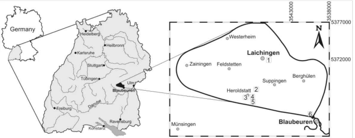
Fig. 1. The catchment area with the Blautopf Spring and the investigated caves; 1 = Laichinger
Tiefenh ¨ohle (LTH), 2 = Hawaii-Schacht (HWS), 3 = precipitation sampling point, 4 = sewage plant of Heroldstatt, 5 = Sontheimer H ¨ohle (SH) and 6 = Blautopf.
HESSD
5, 1267–1287, 2008 Storage and transport in cave seepage K. Schwarz et al. Title Page Abstract Introduction Conclusions References Tables Figures ◭ ◮ ◭ ◮ Back CloseFull Screen / Esc
Printer-friendly Version Interactive Discussion
Fig. 2. Position profile of the sampling sites in the Laichinger Tiefenh ¨ohle, TK: S ¨achsische
HESSD
5, 1267–1287, 2008 Storage and transport in cave seepage K. Schwarz et al. Title Page Abstract Introduction Conclusions References Tables Figures ◭ ◮ ◭ ◮ Back CloseFull Screen / Esc
Printer-friendly Version Interactive Discussion
Fig. 3. Graph (a) shows the δ18O composition of the rainfall (Heroldstatt), the spring (Blautopf) and the seepage water (Laichinger Tiefenhhle); (b) shows a more detailed δ18O composition of the spring and the seepage water (legend see a). The lower graph (c) shows the precipitation and the discharge. Note the different scales on the y-axes. The standard deviation of the18O measurements is indicated in graph (b) top right.
HESSD
5, 1267–1287, 2008 Storage and transport in cave seepage K. Schwarz et al. Title Page Abstract Introduction Conclusions References Tables Figures ◭ ◮ ◭ ◮ Back CloseFull Screen / Esc
Printer-friendly Version Interactive Discussion
Fig. 4. (a) Local meteoric water line of the Blautopf Catchment with evaporation trend (b)
HESSD
5, 1267–1287, 2008 Storage and transport in cave seepage K. Schwarz et al. Title Page Abstract Introduction Conclusions References Tables Figures ◭ ◮ ◭ ◮ Back CloseFull Screen / Esc
Printer-friendly Version Interactive Discussion
Fig. 5. Schematic representation of the different flow paths during base flow conditions (left)