HAL Id: hal-00298541
https://hal.archives-ouvertes.fr/hal-00298541
Submitted on 5 May 2008HAL is a multi-disciplinary open access
archive for the deposit and dissemination of sci-entific research documents, whether they are pub-lished or not. The documents may come from teaching and research institutions in France or abroad, or from public or private research centers.
L’archive ouverte pluridisciplinaire HAL, est destinée au dépôt et à la diffusion de documents scientifiques de niveau recherche, publiés ou non, émanant des établissements d’enseignement et de recherche français ou étrangers, des laboratoires publics ou privés.
The equilibrium flow and mass balance of the Taku
Glacier, Alaska 1950?2006
M. S. Pelto, S. R. Mcgee, G. W. Adema, M. J. Beedle, M. M. Miller, K. F.
Sprenke, M. Lang
To cite this version:
M. S. Pelto, S. R. Mcgee, G. W. Adema, M. J. Beedle, M. M. Miller, et al.. The equilibrium flow and mass balance of the Taku Glacier, Alaska 1950?2006. The Cryosphere Discussions, Copernicus, 2008, 2 (3), pp.275-298. �hal-00298541�
TCD
2, 275–298, 2008Equilibrium flow of Taku Glacier, Alaska
M. S. Pelto et al. Title Page Abstract Introduction Conclusions References Tables Figures ◭ ◮ ◭ ◮ Back Close
Full Screen / Esc
Printer-friendly Version Interactive Discussion
The Cryosphere Discuss., 2, 275–298, 2008 www.the-cryosphere-discuss.net/2/275/2008/ © Author(s) 2008. This work is distributed under the Creative Commons Attribution 3.0 License.
The Cryosphere Discussions
The Cryosphere Discussions is the access reviewed discussion forum of The Cryosphere
The equilibrium flow and mass balance of
the Taku Glacier, Alaska 1950–2006
M. S. Pelto1, S. R. McGee2, G. W. Adema5, M. J. Beedle4, M. M. Miller2, K. F. Sprenke2, and M. Lang3
1
Nichols College Dudley, MA 01571, USA
2
Glaciological and Arctic Sciences Institute, University of Idaho, Moscow ID 83843, USA
3
Institute of Geodesy, Universit ¨at der Bundeswehr, Werner Heisenberg Weg, 85577 Neubiberg, Germany
4
Geography Program, University of Northern British Columbia, 3333 University Way, Prince George, B.C. V2L 2R4, Canada
5
Denali National Park and Preserve, P.O. Box 9, Denali Park, AK 99755, USA Received: 11 March 2008 – Accepted: 11 March 2008 – Published: 5 May 2008 Correspondence to: M. S. Pelto ([email protected])
TCD
2, 275–298, 2008Equilibrium flow of Taku Glacier, Alaska
M. S. Pelto et al. Title Page Abstract Introduction Conclusions References Tables Figures ◭ ◮ ◭ ◮ Back Close
Full Screen / Esc
Printer-friendly Version Interactive Discussion
Abstract
The Taku Glacier, Alaska has advanced 7.5 km since the late nineteenth century, while all other primary outlet glaciers of the Juneau Icefield are in retreat. The Juneau Icefield Research Program has completed field work on the Taku Glacier annually since 1946. The collected observations of surface mass balance, glacier velocity and glacier
thick-5
ness at Profile IV 29 km above the terminus and 4 km above the equilibrium line provide a means to assess the equilibrium nature of the Taku Glacier. Velocity measured over a twelve month span and annual summer velocity measurements completed at a Profile IV from 1950–2006 indicate insignificant variations in velocity seasonally or from year to year. The consistency of velocity over the 56-year period indicates that in the vicinity
10
of the equilibrium line, the flow of the Taku Glacier has been in an equilibrium state. Surface mass balance was positive from 1946—1988 averaging +0.42 m a−1. This led to glacier thickening. From 1988–2006 an important change has occurred and annual balance has been −0.14 m a−1, and the glacier thickness has ceased increasing
along Profile IV.
15
Field measurements of ice depth and surface velocity allow calculation of the volume flux at Profile IV. Volume flux is then compared with the surface balance flux from the region of the glacier above Profile IV, determined annually in the field. Above Profile IV the observed mean surface flux is 5.50×10⁸m3/a (±5%), while the calculated volume flux range flowing through profile IV is 5.00–5.47×10⁸m3/a. The mean surface flux has
20
been greater than the volume flux, which has led to slow thickening of the Taku Glacier up to 1988. The thickening has not led to a change in the flow of Taku Glacier at Profile IV.
1 Introduction
Taku Glacier is a temperate, maritime valley glacier in the Coast Mountains of Alaska.
25
TCD
2, 275–298, 2008Equilibrium flow of Taku Glacier, Alaska
M. S. Pelto et al. Title Page Abstract Introduction Conclusions References Tables Figures ◭ ◮ ◭ ◮ Back Close
Full Screen / Esc
Printer-friendly Version Interactive Discussion
It attracts special attention because of its continuing, century-long advance (Pelto and Miller, 1990; Post and Motyka, 1995), while all other outlet glaciers of the Juneau Icefield are retreating. Taku Glacier is also noteworthy for its positive mass balance from 1946–1988 (Pelto and Miller, 1990), during a period when alpine glacier mass balances have been dominantly negative (Dyugerov and Meier, 1997). Finally, it is
5
unique as the thickest alpine glacier yet measured, with a fjord extending 38–48 km upglacier from its terminus (Nolan et al., 1995).
The Juneau Icefield Research Program (JIRP) has completed field work on the Taku Glacier annually since 1946 (Miller, 1963; Pelto and Miller, 1990). In this paper we present a data set for the Taku Glacier that is unique in its temporal extent containing:
10
1) Surface velocity data Profile IV, spanning 56 years, a single transverse profile prior to 1993 at the location of the lower line and two parallel transverse profiles, separated by 0.24 km since 1993 (Fig. 2); 2) Seismic profiling depth data along Profile IV; 3) Centerline longitudinal velocity transects from the glacier divide to the ablation zone; and 4) Surface mass balance data from 1946–2006. From this data we determine
15
surface balance and volume balance transfers. This provides a field-based quantitative determination of the volume flux at multiple locations.
Taku Glacier is divided into three zones that describe both mass balance and flow dynamics: (1) The ablation zone, below the mean annual ELA of 925 m (113 km2), descends the trunk valley with no tributaries joining the glacier, and only the
distribu-20
tary tongue, Hole in the Wall, leaving the glacier 9 km above the terminus. (2) The lower neve zone, extending from the ELA at 925 m to 1350 m, is a zone where summer ablation is significant (178 km2). All the main tributaries (Southwest, West, Matthes, Demorest, and Hades Highway) join in this zone. Profile IV is in this zone, and com-prises the flow of the Matthes and West Branch. (2) The upper neve zone extends from
25
1350 m to the head of the glacier (380 km2), comprising the principal accumulation re-gion for each tributary except the Southwest Branch. Ablation is limited in this zone, with much of the summer meltwater refreezing within the firnpack. This refreezing results in a unique signature in SAR imagery (Ramage et al., 2000).
TCD
2, 275–298, 2008Equilibrium flow of Taku Glacier, Alaska
M. S. Pelto et al. Title Page Abstract Introduction Conclusions References Tables Figures ◭ ◮ ◭ ◮ Back Close
Full Screen / Esc
Printer-friendly Version Interactive Discussion
Taku Glacier has been advancing since 1890: It advanced 5.3 km between 1890 and 1948 (Post and Motyka, 1995; Pelto and Miller, 1990). The glacier advanced 1.8 km from 1948–1988 (Post and Motyka, 1995), and 0.4 km from 1988 to 2003. The advance rate measured by distance is slowing. The rate of advance is best assessed in terms of area as the terminus lobe is spreading out on a terminus shoal. Post and Motyka
5
(1995) noted that the rate from 1948–1963 was 0.428 km2a−1, 0.345 km2/year from 1963–1979 and 0.11 km2a−1 from 1979–1988. The slowing of the advance has been attributed to the impedance of the terminus outwash plain shoal (Post and Motyka, 1995), but it has also been conjectured as due to the inability of the mass balance to sustain this advance. With an AAR of 82, Taku Glacier had a continuously
posi-10
tive mass balance from 1946–1994, that has driven the continued advance (Pelto and Miller, 1990). Pelto and Miller (1990) postulated that the positive mass balance from 1946–1985, would drive the continued advance until the end of the century regard-less of mass balance in the ensuing years. From 1988–2006 mass balance has been slightly negative, however the glacier has continued to advance as expected.
15
2 Data collection
2.1 Surface mass balance
JIRP has measured the annual balance of the Taku Glacier from 1946 to 2006 (Pelto and Miller, 1990; Miller and Pelto, 1999). Glacier annual mass balance is the difference between the net snow accumulation and net ablation over one hydrologic year. On
non-20
calving glaciers, such as the present Taku Glacier, surface mass balance observations are used to identify changes in glacier volume. JIRP has relied on applying consis-tent methods at standard measurement sites (Pelto and Miller, 1990; Miller and Pelto, 1999). On the Taku Glacier 17 test pits at fixed sites are completed directly measuring the snow water equivalent (SWE), the migration of the transient snow line is monitored,
25
TCD
2, 275–298, 2008Equilibrium flow of Taku Glacier, Alaska
M. S. Pelto et al. Title Page Abstract Introduction Conclusions References Tables Figures ◭ ◮ ◭ ◮ Back Close
Full Screen / Esc
Printer-friendly Version Interactive Discussion
1990). The majority of the snowpits are in the region from 950–1400 m, within 10 km of Profile IV. In 1984, 1998 and 2004, JIRP measured the mass balance at an additional 100–500 points with probing transects in the accumulation area to better determine the distribution of accumulation around the test pit locations. Measurements were taken along profiles at 100–250 m intervals. The standard deviation for measurements sites
5
within 3 km, with less than a 100 m elevation change, was ±0.09 m/a; this indicates the consistency of mass balance around the test pit sites. Another possible source of error is the assumption that the density measured at test pits is representative of a larger area. However, a study at 40 points within 1 km2at different elevations in different years resulted in a standard deviation of ±0.07 m w.e. in a snow pack of 1 to 2 m, displaying
10
the highly uniform density of snow on the Taku Glacier in late summer (Pelto and Miller, 1990).
The measurements of retained accumulation are completed during late July and August and are adjusted to end of the balance year values. This is done via daily ablation rates derived through stake measurements and migration of the transient snow
15
line (Pelto and Miller, 1990; Miller and Pelto, 1999).
Possible errors for the Taku Glacier mass balance record include the sparse density of measurement points (1 per 13 km2), extrapolation to the end of the balance year, infrequent measurements of melting in the ablation zone, and measurements carried out by many different investigators. However, Pelto and Miller (1990), suggest that
20
these sources of error are mitigated by annual measurements at 17 fixed locations, using nine years of ablation data to extrapolate mass balance in the ablation zone, using a balance gradient derived from the 17 fixed sites and known values for the ablation zone that shifts in altitude from year to year based on the ELA, and through supervision of field work by at least one experienced researcher. JIRP has utilized
25
the same methods on the Lemon Creek Glacier where independent long term radar surface profiling has indicated the accuracy of the record (Miller and Pelto, 1999). The principal error is the lack of data from the ablation zone. In this paper we are utilizing data only from the accumulation zone.
TCD
2, 275–298, 2008Equilibrium flow of Taku Glacier, Alaska
M. S. Pelto et al. Title Page Abstract Introduction Conclusions References Tables Figures ◭ ◮ ◭ ◮ Back Close
Full Screen / Esc
Printer-friendly Version Interactive Discussion
An independent measure of mass balance is now available in the form of direct mea-surement of the surface elevation of the glacier at specific points. The elevation has been determined annually since 1993 at fixed locations along Profile IV using differ-ential GPS as part of the velocity surveying program. GPS annual elevation change measurements along Profile IV at 1100 m show a strong correlation with annual mass
5
balance measurements. This would be expected as elevation at the mean ELA is likely to rise with increased accumulation during years of positive mass balance, and fall with increased ablation during years of negative mass balance. Glacier dynamics also affect surface elevation, as the glacier can have either an emergent of submergent component to velocity. In the vicinity of the ELA as is the case at Profile IV this factor
10
is minimized. Further the stable velocity indicates that there has not been a change in glacier dynamics that would alter the emergent velocity.
2.2 GPS survey methods
A key objective of the JIRP surveying program is to collect data that allows quantitative comparison of surface movements and surface elevation change from year to year.
15
All geodetic observations from 1993–2006 on the icefield are made using a differ-ential GPS method. Profile measurements were determined using the real time kine-matic GPS technique, which involved sending a correction signal from the reference station to a mobile rover unit in real time. All JIRP surveying utilizes survey-grade, dual-frequency, real-time kinematic GPS systems including the Leica System 300,
Le-20
ica System 530, and Trimble 5700 units.
Since 1993 Profile IV has been established each year with the same number of survey flags, flag spacing, and flag location. It consists of 31 flags arranged in two parallel transects, placed approximately 240 m apart, which are offset to form a series of 29 triangles between the 16 flags on the down glacier transect and the 15 flags on
25
the up glacier transect. All surveys since 1993 have utilized this arrangement, which allows for the computation of strain rates, height change, and velocity. Standard stake-out coordinates specify the exact easting and northing positions for each flag and are
TCD
2, 275–298, 2008Equilibrium flow of Taku Glacier, Alaska
M. S. Pelto et al. Title Page Abstract Introduction Conclusions References Tables Figures ◭ ◮ ◭ ◮ Back Close
Full Screen / Esc
Printer-friendly Version Interactive Discussion
loaded into the roving GPS unit and the operator navigates to within 0.5 m of the flag coordinates. A roving receiver is mounted on an aluminum monopole inserted into the same hole that the survey flag is placed. The height above the snow surface of the antenna is noted. The position is then recorded and a survey flag is placed into the snow in the same location where the rover’s range pole was positioned for the
5
measurement. A second survey is done 5 to 10 days later. The coordinates of the first and second surveys are then analyzed to determine the surface velocity and direction of movement. For all surveys, the reference receiver is centered and leveled over a bedrock benchmark at Camp 10, adjacent to Profile IV (Fig. 2).
The major focus of the survey program is to continue the annual survey of standard
10
movement profiles on the Taku Glacier and its main tributaries. A major component of this effort is the annual survey of a longitudinal profile down the centerline of the Matthes Branch and the Taku Glacier, from the glacier divide (located 58 km from the terminus), downglacier to 12 km above the terminus. The surface velocity and surface slope are observed at survey locations spaced 0.5 km apart. The longitudinal profile
15
has been surveyed annually since 1999. 2.3 Seismic methods
Seismic methods are required to determine ice depths on transverse profiles because of the thickness of the Taku Glacier (Nolan et al., 1995). The seismic program com-pleted measurements of ice thickness along eight transects across the glacier, each
20
following the same transects and using the same points used in the GPS movement and elevation surveys.
The seismic methods used for determining ice thickness are typical. A Bison 9024 series seismograph was used with 24 high-frequency (100 Hz) geophones to record the seismic signals produced by explosive charges. The geophones were spaced at
25
30 m intervals along profile lines that are perpendicular to the direction of glacier flow, covering 690 m with each geophone spread. Explosive detonations (shots) were gen-erally made at 500 m intervals from each end of the geophone spread, to a maximum
TCD
2, 275–298, 2008Equilibrium flow of Taku Glacier, Alaska
M. S. Pelto et al. Title Page Abstract Introduction Conclusions References Tables Figures ◭ ◮ ◭ ◮ Back Close
Full Screen / Esc
Printer-friendly Version Interactive Discussion
distance of 2000 m. Shot and geophone locations were surveyed using standard dif-ferential GPS surveying techniques, accurate to ±5 cm. Up to twelve shots were taken on each profile, with up to four reflectors evident on each shot’s record. The seismo-graph was normally set to record two seconds of data, recording at a 0.25 ms sampling rate. The energy for a shot was produced by 4 to 20 sticks of Kinepak (1/3 stick)
ex-5
plosive (ammonium nitrate and petroleum distillate combination), buried approximately 1 m deep in the firn.
Reflections from the glacier bed were generally clear and easy to recognize on the records by their frequency, character, and distinct moveout times. Migrations were completed using the common-depth-point technique described in Dobrin (1960) and
10
adapted by Sprenke et al. (1997). Calculations were made using a constant ice velocity of 3660 m/s, a value determined from P-wave first arrival times. The migration and geomorphic profiling process is based on the simplifying assumption that the glacier cross-sections are two-dimensional. The results on Profile IV match closely the results of Nolan et al. (1995), with a maximum depth of 1450 m in this study versus 1400 m.
15
3 Data observations
3.1 Mass balance
The annual balance record shows a markedly positive trend from 1946–1988 period. The mean annual balance for the 42-year period is 0.42 m a−1, representing a total thickening of 17.5 m w.e, 20 m in total ice thickness (Fig. 3). From 1988–2006 mass
20
balance changed significantly and has been slightly negative averaging −0.14 m a−1, a 2.7 m of water equivalent loss, or 3.0 m of glacier thickness change. This represents a total period change of 17 m. Observations along a profile surveyed in 1952 and 1993 indicated surface elevation changes ranged from 10–15 m in the upper accumulation zone of the Take Glacier from 1952–1998 (Welsch and Lang, 1998), and 20–30 in the
25
TCD
2, 275–298, 2008Equilibrium flow of Taku Glacier, Alaska
M. S. Pelto et al. Title Page Abstract Introduction Conclusions References Tables Figures ◭ ◮ ◭ ◮ Back Close
Full Screen / Esc
Printer-friendly Version Interactive Discussion
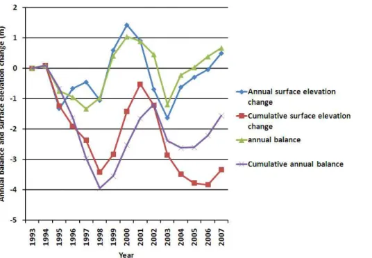
correlation between the average surface elevation change of a Profile IV across the Taku Glacier and net mass balance is 0.77 (95% significance) (Fig. 4). A comparison of cumulative surface height change along Profile IV from 1993–2006 and mean surface balance yield −3.5 m w.e. and −2.6 m w.e., respectively. The difficulty in using height changes is the impact of glacier dynamics. In this case the consistency of the velocity
5
over the last 50 years would suggest that glacier dynamics changes would not be impacting surface elevation substantially. This region of the glacier has a very limited vertical velocity vector. The next task in this research program is to determine the height changes at survey location along additional profiles over an extended period, to determine the utility of the surface level change surveys for mass balance assessment
10
at other locations on the glacier.
With the distribution of annual balance more accurately mapped in the lower neve section of the glacier based on the 1998, 2003 and 2004 combined snowpit and prob-ing measurements, mean annual surface flux was determined both for the glacier region above Profile IV, summing the products of the area observed between each
15
0.2 m mass balance interval and the annual balance for that interval. The mean sur-face flux accumulating above Profile IV for the 1950–2004 period was calculated to be 5.5×10⁸m3a−1.
3.2 Transverse velocity profiles
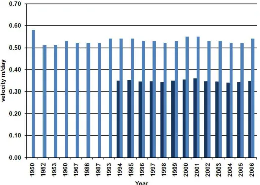
Surface velocity has been constant over a 50-year period on the Taku Glacier at Profile
20
IV (Fig. 5) (Miller, 1963; Dallenbach and Welsch, 1993; Lang, 1997; McGee, 2000). Measurements have focused primarily on summer field measurement of velocity. From 1950–1992 Profile IV was established in the same general location, though there was no means to ascertain that the stakes were positioned identically. In 1993, the profile was standardized at its present location and configuration. In Fig. 5 the mean velocity
25
for the center section of the glacier, from Flag 10 through Flag 24, is noted for all pub-lished surveys. The maximum is 0.58 m day−1 and the minimum 0.51 m day−1, other
indi-TCD
2, 275–298, 2008Equilibrium flow of Taku Glacier, Alaska
M. S. Pelto et al. Title Page Abstract Introduction Conclusions References Tables Figures ◭ ◮ ◭ ◮ Back Close
Full Screen / Esc
Printer-friendly Version Interactive Discussion
vidual years is nearly identical (Fig. 6). This illustrates that at specific stake locations reoccupied each summer along Profile IV there is remarkable uniformity of flow from year to year (Fig. 6). Standard deviation ranges from 0.010–0.020 m day−1 for each flag. This is always less than 5% of the total velocity.
Annual velocity shows no significant variations based on year round measurement
5
of the movement of the top of a glacier borehole and the associated semi-permanent camp from 1950–1953 along Profile IV (Miller, 1963). Movement of a meteorologic station instrument that endured from 1997 to 1998 on Profile IV provided a second measure of mean annual velocity, 0.60 m day−1 versus mean observed summer veloc-ity for this same location of 0.61 m day−1. A magnet was buried in the glacier in July
10
2003 and then checked in July 2004 to identify annual glacier velocity at Profile IV. The annual velocity was 0.587 m day−1and the summer velocity was 0.588 m day−1.
Many temperate glaciers have a substantial component of glacier sliding that de-pends on bed hydrology, hence displaying seasonal variations. Taku Glacier, however, has exceptionally thick ice, and a low basal gradient. The flow law for internal
defor-15
mation suggests that negligible basal sliding is taking place in the accumulation zone (Nolan et al., 1995). The lack of seasonal velocity changes noted in this study and the remarkable uniformity in velocity suggest that sliding is a minor part of the glacier velocity at Profile IV. It is unlikely that a glacier of this size would slow down each fall or winter, and then accelerate to exactly the same speed the following summer.
20
3.3 Longitudinal profile
The variation in velocity along a longitudinal profile extending from Goat Ridge at 800 m elevation, 20 km from the terminus, up the main trunk of the glacier, along the Matthes Branch, to the ice divide is shown in Fig. 7. This variation indicates generally increasing velocity with distance down glacier from the divide at Point 94 to Point 13 just below
25
the ELA. One notable deviation from the pattern of steady velocity increase is where the glacier steepens as Taku Glacier leaves the high plateau and enters the narrower valley of the Matthes Branch, causing a rapid acceleration from Point 81 to point 76.
TCD
2, 275–298, 2008Equilibrium flow of Taku Glacier, Alaska
M. S. Pelto et al. Title Page Abstract Introduction Conclusions References Tables Figures ◭ ◮ ◭ ◮ Back Close
Full Screen / Esc
Printer-friendly Version Interactive Discussion
The glacier then slows under longitudinal compression as the surface slope declines from Point 76 to point 66. A steady increase in surface velocity than ensues to Point 13. The velocity along this longitudinal profile has been repeated in 2001 and 2004. The maximum velocity change was 0.02 m day−1, and the mean change for each point was 0.004 m day−1. Again, this indicates the annual and seasonal consistency of velocity
5
along the glacier and the equilibrium nature of its flow (Fig. 7). Profile IV is in the middle of a region of steady velocity increase (Fig. 7).
3.4 Glacier thickness
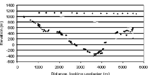
The greatest thickness of the Taku Glacier was noted to be 1477 m at Goat Ridge, 22 km above the terminus (Nolan et. al., 1995). The centerline depth of the glacier is
10
greater than 1400 m at Profile IV (Fig. 8). The glacier thickness exceeds 1000 m for a width of approximately 2000 m in the center of the glacier. This section of the glacier coincides with the region with velocities in excess of 0.5 m day−1. The minimum glacier bottom elevation at Profile IV is approximately −350 m. The transverse bed profile at Profile IV indicates benches on both the east and west sides of the glacier. The bench
15
on the east side is an extension of the North Basin that is at the base of Taku B and just north of Camp 10. The bench on the west side lacks a clear surface topographic expression.
4 Calculation of volume flux
With direct measurement of surface velocity, ice thickness and width for each
incre-20
ment of glacier width on the profiles, the only unknown in determining volume flux is determination of depth average velocity. Several points led Nolan et al. (1995) to con-clude that basal sliding is minimal. Most importantly calculation of basal shear stress is 125 kPa. We determined basal shear stress to be 120–180 kPa along Profile IV. These values are beyond that at which substantial basal sliding would be anticipated. In
TCD
2, 275–298, 2008Equilibrium flow of Taku Glacier, Alaska
M. S. Pelto et al. Title Page Abstract Introduction Conclusions References Tables Figures ◭ ◮ ◭ ◮ Back Close
Full Screen / Esc
Printer-friendly Version Interactive Discussion
dition, the consistency in velocity each summer and in annual velocity indicates that there is negligible seasonal fluctuation in velocity in the vicinity of Profile IV. Seasonal fluctuations are generally the result of changes in sliding.
To determine depth average velocity (Ud) we have applied the Eq. (1) (van der Veen, 1999; Nick et al., 2007), using values from the center of the glacier.
5 Ud = 2A H n + 2S n d (1)
whereA=4.6×10⁻¹⁰kpa−3day−1 is the rate factor (Paterson, 1981), n=3 is the
flow-law exponent,H is the measured ice thickness (1400 m) and Sd the basal shear stress noted above (125–180 kpa)(or basal drag). Plugging these values into Eq. (1) gives
Ud = (2)(4.6 × 10⁻¹⁰kpa−3day
−1
)(1400)/5 × (1203) = 0.45 m day−1 (2)
10
The lower value for basal shear stress is used at the suggestion of van der Veen (1999) since part of the driving stress is likely balanced by lateral drag. We then use the calculated value ofUd to calculateUs from Eq. (3) (van der Veen, 1999):
Plugging the calculatedUd velocity into Eq. (3) gives the surface velocity in Eq. (4)
Us =n + 2
n + 1Ud = 1.25 Ud (3)
15
0.56 m day−1/1.25 = 0.45 m day−1 (4)
Us of 0.56 m day−1 is an excellent agreement with the observed surface velocity of
Us=0.6 m day−1. This suggests that it is reasonable to use Eq. (3) to determineUd for
each increment of glacier width.
The meanUs velocity between each two survey flags is used to represent the
aver-20
ageUsfor that width increment of the glacier. The mean depth for that width increment
from the seismic profile is then determined. The product of the width of the increment and depth of the increment provide the mean cross sectional area. The mean Us for each increment is converted to a meanUd using Eq. (3).
TCD
2, 275–298, 2008Equilibrium flow of Taku Glacier, Alaska
M. S. Pelto et al. Title Page Abstract Introduction Conclusions References Tables Figures ◭ ◮ ◭ ◮ Back Close
Full Screen / Esc
Printer-friendly Version Interactive Discussion
The volume flux was determined separately for parallel survey lines along Profiles 4 (upper line and lower line) and for the Profile 7 lower line. For Profile IV, 29 km above the terminus, the expected surface flux was 5.50×10⁸m3a−1(±10%), the volume flux range was 5.00–5.47×10⁸m3a−1, with a mean of 5.25×10⁸m3a−1 for the upper line and 5.27×10⁸m3a−1 for the lower line. This indicates a slightly positive balance and
5
glacier thickening above Profile IV for the 1950–2006 period, which is corrobated by field observations (Welsch and Lang, 1998). The thickness change observations are in the range of expected values for the observed positive surface mass balance. The calculated volume flux is based on the 1946–2006 average mass balance profile for the glacier and not for a given year. The surface flux during recent negative balance
10
years would obviously give a lower surface flux value and in fact the surface elevation in the vicinity of Profile IV has not been increasing since 1993.
5 Conclusion
The results indicate that Taku Glacier has had an equilibrium flow, with no significant annual velocity changes in the last 50 years. Furthermore, although seasonal
vari-15
ations had been expected (Miller, 1963), observations of velocity throughout the year indicate no seasonal variations, probably due to high basal shear stress which prevents sliding. The surface mass balance accumulating above Profile IV in the last half cen-tury is in excess of the volume flux through the profile. The result, supported by both survey results of JIRP and radio echo sounding by the University of Alaska-Fairbanks
20
(Nolan et al., 1995), is glacier thickening. The sustained thickening, positive balance, and consistent flux of the 1946–1988 period suggested that the glacier terminus would continue to advance (Pelto and Miller, 1990). From 1988–2005 the mass balance has been slightly negative, and the glacier has thinned slightly (Fig. 3) though the volume flux at Profile IV has not declined appreciably. The significant change in glacier mass
25
balance beginning in 1988 is expected to influence the glacier velocity, volume flux and eventually the terminus, if it is sustained for another 20+ years. A reduced mass
bal-TCD
2, 275–298, 2008Equilibrium flow of Taku Glacier, Alaska
M. S. Pelto et al. Title Page Abstract Introduction Conclusions References Tables Figures ◭ ◮ ◭ ◮ Back Close
Full Screen / Esc
Printer-friendly Version Interactive Discussion
ance, along with the proglacial delta and expanding front of the glacier noted by Post and Motyka (1995), would lead to a reduction in the advance rate. The glacier velocity did not change appreciably as the glacier thickened by 10–20 m at Profile IV and it is expected that it would take a thinning of more than this to substantially alter glacier velocity.
5
References
Daellenbach, K. and Welsch, W.: Determination of Surface Velocities, Strain Rates, and Mass Flow Rates on the Taku Glacier, Juneau Icefield, Alaska, Zeitschrift fur Gletscherkunde und Glazialgeologie, 26(2), 169–177, 1993.
Dobrin, M. B.: Introduction to Geophysical Prospecting, 3rd Edition, McGraw-Hill, New York,
10
201–254, 1960.
Dyugerov, M. B. and Meier, M. F.: Year to year fluctuations of global mass balance of small glaciers and their contributions to sea level, Arctic and Alpine Res., 29, 392–402, 1997. Lang, M.: Geodetic Activities of the 1997 Juneau Icefield Research Program Field Season,
Open File Survey Report, Juneau Icefield Research Program, Foundation for Glacier and
15
Environmental Research, Moscow, Idaho, 1997.
McGee, S.: Juneau Icefield GPS Movement Profile Coordinates, JIRP Open File Survey port, Juneau Icefield Research Program, Foundation for Glacier and Environmental Re-search. Moscow, Idaho, 2000.
Miller, M. M.: Taku Glacier Evaluation Report, State of Alaska, Dept. of Highways and Bureau
20
of Public Roads, US Dept. of Commerce, 1963.
Miller, M. M. and Pelto, M.: Mass Balance measurements on the Lemon Creek Glacier, Juneau Icefield, Ak 1953–1998, Geogr. Ann., 81A, 671–681, 1999.
Nick, F. M., van der Veen, C. J., and Oerlemans, J.: Controls on advance of tidewater glaciers: Results from numerical modeling applied to Columbia Glacier, J. Geophys. Res., 112,
25
F03S24, doi:10.1029/2006JF000551, 2007.
Nolan, M., Echelmeyer, K., Motyka, R., and Trabant, D.: Ice thickness measurements of Taku Glacier, Alaska, USA, and their relevance to its recent behavior, J. Glaciol., 41(139), 541– 552, 1995.
TCD
2, 275–298, 2008Equilibrium flow of Taku Glacier, Alaska
M. S. Pelto et al. Title Page Abstract Introduction Conclusions References Tables Figures ◭ ◮ ◭ ◮ Back Close
Full Screen / Esc
Printer-friendly Version Interactive Discussion
Nye, J. F.: The flow of a glacier in a valley of rectangular, elliptic or parabolic cross section, J. Glaciol., 5(41), 661–690, 1965.
Paterson, W. S. B.: The Physics of Glaciers, 2nd ed., Pergamon Press, Oxford, 1981.
Pelto, M. and Miller, M. M.: Mass Balance of the Taku Glacier, Alaska from 1946 to 1986, Northwest Science, 64(3), 121–130, 1990.
5
Post A. and Motyka, R.: Taku and Le Conte Glaciers, Alaska: Calving speed control of late-Holocene asynchrounous advances and retreats, Phys. Geogr., 16, 59–82, 1995.
Ramage, J. M., Isacks, B. L., and Miller, M. M.: Radar Glacier zones in southeast Alaska, U.S.A.: field and satellite observations, J. Glaciol., 46(153), 287–296, 2000.
Sprenke, K. F., Miller, M. M., McDonald, F., Haagen, C., Adema, G., Kelly, M., Barbour, S.,
10
and Caceres, B.: Geophysical investigation of the Taku-Llewellyn Divide: A NASA Earth Systems Field Research Project, Juneau Icefield, Alaska, Juneau Icefield Research Pro-gram Geophysics Open File Report 97-1, Moscow, Idaho, Glaciological and Arctic Science Institute, University of Idaho, 1997.
Van der Veen, C. J.: Fundamentals of Glacier Dynamics, Lisse: A. A. Balkema, 462 pp., 1999.
15
Welsch, W., Lang, M., and Miller, M. M.: Geodetic Activites – Juneau Icefield, Alaska 1981– 1996, Schriftenreihe des Studiengangs Vermessungskunde. Universit ¨at der Bundeswehr, Heft 50, 1996.
Welsch, W. and Lang, M.: Geodetic Activities of the 1998 Juneau Icefield Research Program Field Season, Open File Survey Report, Juneau Icefield Research Program, Foundation for
20
TCD
2, 275–298, 2008Equilibrium flow of Taku Glacier, Alaska
M. S. Pelto et al. Title Page Abstract Introduction Conclusions References Tables Figures ◭ ◮ ◭ ◮ Back Close
Full Screen / Esc
Printer-friendly Version Interactive Discussion Table 1. The calculated volume flux at Profile IV. Volume flux is in 108m3a−1. Annual values
are followed by a comparison of the mean volume flux, mean observed surface flux and the difference between them. The difference in this case is a positive surface flux. The volume flux is determined from annual measurements. The surface flux is the mean for the 1946–2004 period.
1996 1997 1998 1999 2000 2001 2004 Mean Surface Difference 4LL 5.25 5.34 5.07 5.38 5.42 5.41 5.20 5.27 5.5 0.20 4UL 5.33 5.22 5.19 5.23 5.33 5.39 5.17 5.25 5.5 0.23
TCD
2, 275–298, 2008Equilibrium flow of Taku Glacier, Alaska
M. S. Pelto et al. Title Page Abstract Introduction Conclusions References Tables Figures ◭ ◮ ◭ ◮ Back Close
Full Screen / Esc
Printer-friendly Version Interactive Discussion
TCD
2, 275–298, 2008Equilibrium flow of Taku Glacier, Alaska
M. S. Pelto et al. Title Page Abstract Introduction Conclusions References Tables Figures ◭ ◮ ◭ ◮ Back Close
Full Screen / Esc
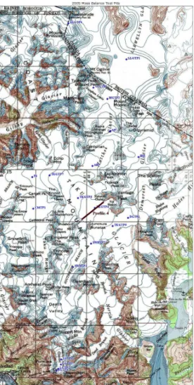
Printer-friendly Version Interactive Discussion Fig. 2. Position of marker flags on Profile IV, for the upper and lower line. Flow direction noted
TCD
2, 275–298, 2008Equilibrium flow of Taku Glacier, Alaska
M. S. Pelto et al. Title Page Abstract Introduction Conclusions References Tables Figures ◭ ◮ ◭ ◮ Back Close
Full Screen / Esc
Printer-friendly Version Interactive Discussion Fig. 3. Annual and cumulative balance of Taku Glacier 1946–2006.
TCD
2, 275–298, 2008Equilibrium flow of Taku Glacier, Alaska
M. S. Pelto et al. Title Page Abstract Introduction Conclusions References Tables Figures ◭ ◮ ◭ ◮ Back Close
Full Screen / Esc
Printer-friendly Version Interactive Discussion Fig. 4. Annual mass balance of the Taku Glacier 1994–2006, and the mean change in glacier
TCD
2, 275–298, 2008Equilibrium flow of Taku Glacier, Alaska
M. S. Pelto et al. Title Page Abstract Introduction Conclusions References Tables Figures ◭ ◮ ◭ ◮ Back Close
Full Screen / Esc
Printer-friendly Version Interactive Discussion Fig. 5. The average velocity for Profile IV for the entire line (dark blue) from 1994–2006, and the
average velocity for the center section (light blue) of Profile IV upper line (between stations 10 and 24) for selected years from 1950–2006.
TCD
2, 275–298, 2008Equilibrium flow of Taku Glacier, Alaska
M. S. Pelto et al. Title Page Abstract Introduction Conclusions References Tables Figures ◭ ◮ ◭ ◮ Back Close
Full Screen / Esc
Printer-friendly Version Interactive Discussion Fig. 6. Observed surface velocity (m day−1) along Taku Glacier Profile IV Upper Line. The lack
TCD
2, 275–298, 2008Equilibrium flow of Taku Glacier, Alaska
M. S. Pelto et al. Title Page Abstract Introduction Conclusions References Tables Figures ◭ ◮ ◭ ◮ Back Close
Full Screen / Esc
Printer-friendly Version Interactive Discussion Fig. 7. Comparison of gradient and velocity along a longitudinal profile, Taku Glacier, Alaska.
Profile IV is at station number 38, note line. Stations are 0.5 km apart. Profile IV is in the midst of a region with steady glacier velocity increases and 1–2% gradient.
TCD
2, 275–298, 2008Equilibrium flow of Taku Glacier, Alaska
M. S. Pelto et al. Title Page Abstract Introduction Conclusions References Tables Figures ◭ ◮ ◭ ◮ Back Close
Full Screen / Esc
Printer-friendly Version Interactive Discussion Fig. 8. Surface elevation of stations along Profile IV and seismically determined bottom