Latest Pliocene to recent thick-skinned tectonics at the Upper Rhine
Graben – Jura Mountains junction
K
AMILU
STASZEWSKI1& S
TEFANM. S
CHMIDKeywords: Neotectonics, Upper Rhine Graben, Jura Mountains, Permo-Carboniferous trough, Rhine-Bresse Transfer Zone, 1356 Basel earthquake
ABSTRACT
The southernmost Upper Rhine Graben and adjacent Jura experienced base-ment-rooted shortening that occurred after the deposition of the Pliocene flu-vial “Sundgau gravels”. Folds affecting the base of these gravels systematically trend NE to ENE. Combined evidence from reflection seismic lines and con-tour maps of the base-Tertiary and base-Pliocene levels indicates that these folds probably formed by thick-skinned reactivation of both NNE-SSW and WSW-ENE-striking faults. This thick-skinned shortening is NW-SE oriented, i.e. parallel to the maximum horizontal stresses inferred from seismotectonics. NNE-SSW-striking faults (paralleling the Upper Rhine Graben) have been re-activated in sinistral strike-slip mode. However, dextrally transpressive reac-tivation of the WSW-ENE-trending faults that belong to the Rhine-Bresse Transfer Zone is interpreted to predominate.
Deflections of recent river courses around the crests of en-échelon-alig-ned surface anticlines suggest that the deformation is ongoing at present.
Retro-deformation of the folds affecting the base of the Sundgau gravels indi-cates horizontal displacement rates of about 0.05 mm/a. This corresponds to a minimum strain rate in the order of 2·10-16s-1, given the maximum time span of
2.9 Ma for this deformation, i.e. the biostratigraphically determined minimum age of the gravels. A change from thin-skinned tectonics, that prevailed during the main phase of Jura folding, to very probably still ongoing thick-skinned tectonics is inferred to have occurred in the Late Pliocene. We speculate that this change might be linked to the incipient inversion of Permo-Carboniferous troughs within the Alpine foreland in general. This inversion in dextrally tran-spressive or purely compressive mode along a WNW-ESE-trending basement fault, that is part of the Rhine-Bresse Transfer Zone, which in turn was pre-structured during the formation of the Permo-Carboniferous troughs, could have triggered the 1356 Basel earthquake.
formation of the URG would only be a passive one during later compressive events. Such pre-existing faults would mere-ly act as nuclei during the formation of Jura-type folds, thrusts and transverse strike-slip structures such as oblique ramps. However, a minority of authors prefers a thick-skinned origin of all, or at least of parts, of the shortening in the Jura Moun-tains and adjacent areas. Thereby pre-existing basement faults would play an active role. They could, for example, be reacti-vated in terms of strike-slip faulting within a basement that is decoupled from folding of the sedimentary cover above the Triassic detachment horizon (Pavoni 1961), or alternatively, by the inversion of faults delimiting the Permo-Carboniferous troughs of the northwestern foreland of the Alps (e.g. Pfiffner et al. 1997).
Controversies addressing the thick-skinned vs. thin-skinned dilemma often overlook the evolution in time and 1 Introduction
1.1 Research objectives
The present day architecture of the northwestern Alpine fore-land largely resulted from the interplay between extensional and collisional tectonics that took place since early Cenozoic times. The resulting interference is particularly complex, where the Eo- to Oligocene southern Upper Rhine Graben (URG) abuts the northern margin of the Mio- to Pliocene fold and thrust belt of the Jura Mountains. The latter formed as a consequence of Alpine subduction and collision.
According to the widely accepted concept of thin-skinned Jura folding, which postulates décollement via complete de-coupling between basement and cover along Triassic evapor-ites (e.g. Buxtorf 1907; Laubscher 1961; Burkhard 1990; Jordan 1992), the role of pre-existing basement faults linked to the
Geologisch-Paläontologisches Institut, Universität Basel, Bernoullistrasse 32, CH-4056 Basel, Switzerland.
1Corresponding author: K. Ustaszewski. E-mail: Kamil.Ustaszewski@unibas.ch 1661-8726/07/020293-20
DOI 10.1007/s00015-007-1226-0 Birkhäuser Verlag, Basel, 2007
space of post-Oligocene shortening in the northwestern Alpine foreland. Evidence for a thin-skinned origin of the main structural features within the Jura fold-and-thrust belt, which essentially formed within a relatively short time span between the Late Miocene and Early Pliocene, is overwhelming and perfectly feasible from both mechanical and geometrical view-points (e.g. Laubscher 1961; Müller & Briegel 1980; Burkhard 1990; Jordan 1992; Sommaruga 1997; Burkhard & Sommaruga 1998). This view can easily be reconciled with thick-skinned reactivation of pre-existing basement faults in latest Pliocene to recent times, i.e. during a late stage or after the formation of the thin-skinned Jura belt, a postulate which is by now sup-ported by abundant evidence (e.g. Becker 2000; Giamboni et al. 2004a,b; Ustaszewski et al 2005a; Ustaszewski & Schmid 2006).
At present, the southern end of the URG is characterised by increased seismicity, as seen in the clustering of seismic events in both the historical and the instrumental earthquake catalogues of Switzerland (Swiss Seismological Service 2003). Earthquakes, for instance, have repeatedly harmed the city of Basel in medieval times. The most severe earthquake occurred in 1356 AD with an estimated epicentral intensity between IX
and X (Mayer-Rosa & Cadiot 1979). The inferred focal depth of this earthquake is at a mid-crustal level, and most other earthquakes in the northwestern Alpine foreland span the entire crustal column down to the base of the upper crust (Deichmann et al. 2000a). This suggests basement reactivation and, hence, a thick-skinned scenario at least for the seismo-genic components of neotectonic activity.
However, despite dedicated research (Meyer et al. 1994; Nivière & Winter 2000; Meghraoui et al. 2001; Ferry et al. 2005; Lambert et al. 2005) the seismic source of the 1356 AD Basel earthquake (strike slip, thrust/reverse or normal fault?) has not yet been unambiguously identified. Also, there is no general agreement yet, whether the currently ongoing defor-mation in the northwestern Alpine foreland still predominant-ly affects the sedimentary cover (ongoing thin-skinned tecton-ics, deep-seated seismogenic activity being of minor impor-tance) or whether basement and cover currently deform by the same amounts (thick-skinned tectonics). Solving such ques-tions is of key importance for seismic hazard assessment stud-ies, issues that require an accurate knowledge of present-day rates of deformation and fault kinematics.
This study contributes to the above-mentioned debates by Fig. 1. Tectonic map of the study area. Geographic names are in italics. F = Florimont anticline, R = Réchésy anticline, M = Mandach thrust.
Ill
Anticline thrust or reverse fault Permian Cenozoic undifferentiated Carboniferous and older detached Mesozoic autochthonous Mesozoic fault
major fault river
10 km Rhein Rh ein Doubs Belfort Belfort Basel Basel Mulhouse S u n d g a u S u n d g a u A j o i e A j o i e Mulhouse
Vosges
Aare Aare Ill Rhein Doubs Aare Zürich Montbéliard Montbéliard S u n d g a u A j o i eM
o l
a s
s e
B
a s
i n
U R G
Altkirch F R MMBlack
Forest
47°30'N 7°E 47°30'Ncombining new results and literature data regarding: (1) geo-morphologic observations, (2) kinematic data from fault-slip analysis and (3) evidence from reflection seismic lines and newly compiled subsurface maps. The data presented in this study favour the interpretation that basement-rooted (i.e. thick-skinned) tectonics are dominant since the latest Pliocene, whereas Jura-type décollement (i.e. thin-skinned) tectonics ceased at about that time. The stress field evolution in the sed-imentary cover is discussed by comparing “paleostresses” (de-rived from the analysis of fault-slip data; Ustaszewski & Schmid 2006) and recent stresses. Furthermore, it is discussed whether the observed neotectonic structures could be related to an incipient (and potentially seismogenic) inversion of Permo-Carboniferous troughs in the subsurface.
1.2 Geological setting and previous work
The study area is located in northwestern Switzerland and ad-jacent France, at the junction of the southernmost URG and
the northern Jura fold and thrust belt (Fig. 1). In the following, we focus only on the regional aspects that are indispensable for understanding the neotectonic setting. More exhaustive de-scriptions of the regional geology are found in Becker (2000), Giamboni et al. (2004a), Dèzes et al. (2004) and Ustaszewski & Schmid (2006). The usage of the term “neotectonic” in this study refers to tectonic processes that occurred since the Late Pliocene.
Among the earliest studies addressing neotectonics in the area were those of Liniger (1963, 1964), who described in great detail a gentle E-W-trending anticline at the junction be-tween the Tabular Jura and the URG in the Ajoie (Réchésy Anticline, Fig. 1). Based on the observation that the gentle anticline affects a sheet of Pliocene gravels (so-called “Sundgau gravels”, see below), he inferred a largely post-Pliocene age of folding which he considered to have occurred at a late stage during thin-skinned Jura deformation. Théobald et al. (1977) tentatively portrayed a number of anti-clines at the southern end of the URG and further west into Fig. 2. Comparison of “paleostress” data derived from the analysis of fault-slip data (see Ustaszewski & Schmid 2006) and recent stress data in the SE corner of the Upper Rhine Graben taken from the 2003 release of the World Stress Map project (Reinecker et al. 2003). The near-surface recent stress data stem from va-rious methods of in-situ stress measurements in the sedimentary cover. The depth of deep-seated seismic events, taken from the inversion of seismotectonic dis-locations, is indicated in km. Note that SHmax-orientations regarding recent near-surface deformation tend to scatter between NNW and NNE, paralleling the shortening directions determined from the fault-slip data, particularly those measured in the detached Mesozoic and in the autochthonous Mesozoic in the Ajoie. SHmax-orientations obtained from seismotectonic activity within the crystalline basement, including Late Paleozoic sediments, however, are predomi-nantly and more systematically NW-SE-oriented. Patterns are as in Fig. 1. Anticline crests are omitted for reasons of legibility. Numbers on map margin refer to Swiss National coordinates.
Rhein Doubs Basel Delémont Delémont Altkirch 1 9 9 19 13 18 21 22 22 9.8 7.1 0.03 12.3 12.2 11.1 11.4 12.1 11.4 18.6 18.4 18.4 18.4 10.2 12.1 10.2 18.2 18.5 23.6 19.1 6 23 23 11.5 7 47°30'N 47°30'N 47°30'N 7°E 7°30'E 7°E 7°30'E 0 5 10 km 575000 575000 600000 600000 625000 625000 250000 250000 275000 275000 shortening
extension fault slip
data (cover) transtension strike-slip SHmax SHmin SHmax Shmin normal faulting in-situ stresses (cover)
stress data from focal
mechanisms
thrust fault normal, tear or strike-slip fault
the Doubs and Ognon valleys, to which they also assigned a post-Pliocene age.
Giamboni et al. (2004a) resumed and expanded the obser-vations of Liniger (1963, 1964) onto a larger area. They identi-fied two E-W-trending, en-échelon aligned surface anticlines of Post-Pliocene age (Florimont and Réchésy anticlines, Fig. 1) at the URG-Tabular Jura junction. Based on interpretations of reflection seismic lines, they attributed the formation of these folds to dextral reactivation of an ENE-WSW-trending pre-ex-isting basement fault system within the Pre-Mesozoic base-ment (see figs. 5 & 7 in Giamboni et al. 2004a). Such faults are widely recognised in the area and belong to a set of faults bounding the ENE-WSW-trending Permo-Carboniferous trough system. This trough system extends eastwards into the
Northern Swiss Permo-Carboniferous trough (Diebold 1988; Diebold & Naef 1990; Diebold et al. 1991; Müller et al. 2002), also referred to as Constance-Frick trough (Diebold & Noack 1997; Laubscher & Noack 1997). This Late Paleozoic trough system is commonly held responsible for nucleating a Paleo-gene-age continental transfer zone between the URG in the NE and the Bresse Graben in the SW. This so-called Rhine Bresse Transfer Zone linked the simultaneous opening of the two graben systems by sinistral transtensive reactivation of ENE-oriented basement faults of the pre-existing Permo-Car-boniferous trough system (Laubscher 1972, 1973; Bergerat & Chorowicz 1981; Illies 1981; Ziegler 1992; Lacombe et al. 1993; Ustaszewski et al. 2005a,b).
Fig. 3. Contour map of the base of the Pliocene Sundgau gravels in metres above sea level (after Giamboni et al. 2004a). Data on the recent stress field comprise in-situ stress measurements and earthquake focal mechanisms, extracted from the World Stress Map project 2003 release (Reinecker et al. 2003). The numbers next to the stress symbols indicate the depth of the events in km. The traces of the cross sections 1 to 3 (Fig. 4) are indicated. The clustered events in the NE cor-ner correspond to the Sierentz 1980 earthquake swarm. Bottom right inset: kinematic sketch of the Illfurth fault explaining the occurrence of restraining and re-leasing bends. Ill Birs Birs Lucelle Lucelle Largue Largue Allaine Allaine Birsig Birsig Rhein 350 400 450 400 500 500 350 400 450 400 350 350 350 400 400 500 13 12.3 12.2 11.1 11.4 12.1 11.4 560000 560000 570000 580000 590000 600000 250000 250000 260000 270000 270000 280000 0 5 km 280000 570000 580000 590000 600000 M e a n s t r e s s (Kastrup et al., 2004) SH max Sh min
anticline surface faults
Sundgau gravels
contours of Sundgau gravels base, isoline distance 10 m syncline
Mesozoic
-Cenozoic boundary Folded Jura front
important surface faults
river / canal
shortening
extension fault slip
data, cover σ1 horizontal σ1 vertical SHmax σ3 in-situ stress, cover focal mechanisms Illfurth Illfurth Fig. 5 3 2 1 3' 2' 1' Ferrette Ferrettefaultfault fault fault Thalbach Thalbach
1.3 Seismicity and recent displacement rates
The orientation of maximum horizontal stresses (SHmax) in the northwestern Alpine foreland, inferred from fault plane solutions for seismic events and the inversion of focal mecha-nisms, is consistently NW-oriented (Plenefisch & Bonjer 1997; Deichmann et al. 2000a; Reinecker et al. 2003; Kastrup et al. 2004; Fig. 2). Down to a depth of about 15 km, there is a pre-dominance of fault plane solutions indicating strike-slip, whereas from 15 km down to the MOHO normal faulting events prevail (Plenefisch & Bonjer 1997; Deichmann et al. 2000a). The extension axes show a very stable NE-SW-orienta-tion throughout.
However, the SHmax-orientations in the sedimentary cover, which is decoupled from the basement (comprising the crystalline basement, Permo-Carboniferous and Lower Trias-sic) along rheologically weak Middle and Upper Triassic evap-orite layers, scatter from NNW over N to NNE, as is primarily deduced from in-situ stress measurements (Baumann 1981; Müller et al. 1987; Becker 1999, 2000; Reinecker et al. 2003; Fig. 2). The depth-dependent change in the orientation of SHmax is particularly well documented in boreholes along the easternmost Folded Jura (Müller et al. 1987, 2002). This de-coupling has been used as an argument for still ongoing dé-collement tectonics. However, stress decoupling between base-ment and cover does not necessarily imply ongoing thin-skinned tectonics, a postulate, which contrasts with recent work providing arguments for currently ongoing thick-skinned reactivation of basement faults (Meyer et al. 1994; Lopes Car-dozo & Granet 2003; Giamboni et al. 2004a; Ustaszewski et al. 2005a).
A recent compilation of GPS-data from 53 permanent sta-tions from 4 different networks in Western Europe, with ob-servation periods of up to 7 years between 1996 and 2003, al-lowed a determination of horizontal displacement rates rela-tive to Eurasia. Stations located between 4° and 16° E, com-prising the domain of the Alps and the northern Alpine foreland, show horizontal displacement rates between 0.1 and 2.9 mm/a relative to Eurasia (Tesauro et al. 2005, their fig. 2). Convergence rates concerning the Swiss part of the northwest-ern Alpine foreland are in the order of less than 1 mm/a (Müller et al. 2002). However, it is uncertain as to how much of the present-day convergence deduced for the earth’s surface is accommodated by seismogenic activity within the directly un-derlying basement.
2 Geomorphologic and geological field evidence for latest Pliocene to recent tectonics
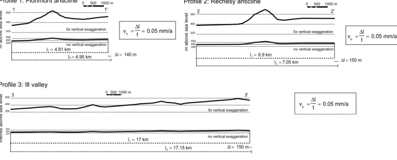
Pliocene fluvial gravels, cropping out in the southernmost URG and the adjacent Jura Mountains, play a key role in deciphering neotectonic (Late Pliocene to recent) activity. These so-called Sundgau gravels unconformably overlie both the Paleogene syn-rift sediments in the URG and the au-tochthonous Mesozoic in the Tabular Jura of the Ajoie (Fig. 3). The Sundgau gravels were deposited by a braided river, which flowed westward through southernmost Alsace (“Sundgau”) towards the Bresse Graben (Théobald 1934; Manz 1936; Liniger 1966). The Sundgau gravels accumulated in a time span from 4.2 to 2.9 Ma, as determined biostrati-graphically (Petit et al. 1996; Fejfar et al. 1998). During this Fig. 4. Three cross sections through the folded base of the Sundgau gravels, amounts of shortening and derived horizontal displacement rates by assuming that shortening started after deposition of the gravels (minimum age 2.9 Ma) and continued up to recent times. See Fig. 3 for location of the sections.
300 400 500 300 400 500 v ≈ ≈0.05 mm/a t l ∆ h Profile 1: Florimont anticline 0 500 1000 m
5x vertical exaggeration no vertical exaggeration l1
l0
m above sea level
4.81 km 4.95 km = = 140 m l= ∆ 1 1' 300 400 500 300 400 500
Profile 3: Ill valley
17 km 17.15 km l l 0 1 = = 150 m l= ∆ 0 5001000 m 5x vertical exaggeration no vertical exaggeration
metres above sea level
3 3' vh ≈∆tl≈0.05 mm/a 300 400 500 300 400 500 400 v ≈ ≈0.05 mm/a t l ∆ h 0 500 1000 m
Profile 2: Réchésy anticline
6.9 km 7.05 km l l 0 1 = = 150 m l= ∆
m above sea level
5x vertical exaggeration no vertical exaggeration
time interval the drainage divide between the North Sea and the Mediterranean Sea was located around the Kaiserstuhl volcano, approximately 60 km N of the area investigated (e.g. Giamboni et al. 2004a, their fig. 4b). This riverbed was aban-doned 2.9 Ma ago, associated with a southward shift of the drainage divide into the western Sundgau. Subsequently, the contiguous gravel cover was dissected by four N- to NW-wards draining tributaries of the Doubs (Allaine) and Rhine (from W to E: Largue, Ill and Thalbach) rivers. These tribu-taries incised into the Paleogene syn-rift fill of the URG, thus exposing the base of the gravel sheet (Fig. 3). The eastern end of the Sundgau gravel sheet W of Basel is clearly ero-sional. Previous authors attributed the southward shift of the
water divide either to a slow-down (or end) of upwarping of the Vosges-Black Forest arch (Dèzes et al. 2004), or alterna-tively, to accelerated subsidence in the northern URG and a concomitant drop of the local base level, causing subsequent regressive erosion in the southern URG (Doebl 1970; Schumacher 2002; Giamboni et al. 2004b). Our own data (Ustaszewski & Schmid 2006 and this work) hint towards a third possible explanation, namely that both abandonment of the Sundgau riverbed and subsequent reorganisation of the drainage system were triggered by shortening-induced neo-tectonic uplift.
The thickness of the Sundgau gravels (Théobald et al. 1958; Liniger 1970a, 1970b; Ruhland et al. 1973) varies between 5 and 20 m. These predominantly clast-supported, crudely bed-ded gravel beds were deposited in a shifting network of shal-low, low-sinuosity channels. Intercalations of sand lenses are very rare. These sedimentological criteria suggest that deposi-tion occurred on a nearly planar surface; hence this surface can be used as a reference plane for deciphering subsequent verti-cal tectonic movements. The contours of the base of the Sundgau gravels show a general increase in elevation from c. 350 m in the N to more than 450 m in the S (Théobald 1934; Giamboni et al. 2004a). Moreover, the contours reveal an array of syn- and anticlines with average amplitudes of 30–50 m and maximum amplitudes of up to 150 m regarding the two en-échelon anticlines in the southwest. These amplitudes ex-ceed the thickness of the gravel sheet by about an order of magnitude. Hence it can be excluded that the contoured folds merely reflect the infilling of a pre-existing topography. Rather they testify to post-2.9 Ma horizontal shortening and related vertical uplift in the southernmost URG (Giamboni et al. 2004a).
Fig. 3 also compares the contours of the base of the Sundgau gravels with the available recent stress orientations for this particular area. The recent stresses, taken from the World Stress Map project (Reinecker et al. 2003), are again those inferred from earthquake focal mechanisms and in-situ stress measurements. The mean stress regime reveals strike-slip characteristics with a maximum horizontal stress (SHmax) oriented at around azimuth 330° (Kastrup et al. 2004). Note that the fold trains in the Sundgau gravels trend largely per-pendicular to present-day SHmax.
2.1 Estimating displacement rates
In order to quantify the amount of post-2.9 Ma horizontal shortening recorded by the Sundgau gravels, three cross-sec-tions through their gently folded base, oriented perpendicular to the contour lines, were compiled and restored (Fig. 4). Pro-files 1 and 2 traverse the two prominent Florimont and Réchésy anticlines (Fig. 1); cross-section 3 runs east of the Ill Valley and across several ENE-trending syn- and anticlines (Fig. 3). The amount of shortening varies between 1% (cross-section 3) and 2.8% (cross-(cross-section 1) across the 3 transects. As-suming this shortening to have commenced earliest at around Fig. 5. Deformation features in the Sundgau gravels related to local extension
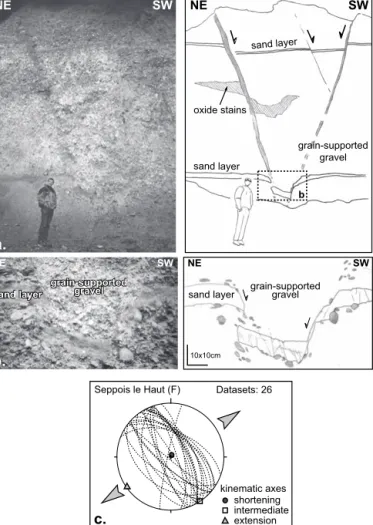
near a releasing bend of strike slip faulting. (a) Conjugate normal faults affec-ting the Late Pliocene Sundgau gravels in an abandoned gravel pit in the Lar-gue valley at Seppois le Haut, France (Swiss coordinates: X=581’600, Y=264’400). Intercalated sand lenses in the grain-supported gravels and oxide stains serve as markers. See Fig. 3 for location. (b) Sand layer affected by cm-to dm-scale conjugate normal faults. Outside the faulted sand layer the shear zone is traceable by rotated and broken pebbles. (c) Representation of fault-orientations and of the shortening and extension axes in a lower hemisphere equal area projection.
sand layer sand layer
sand layer sand layer
NE SW NE SW 10x10cm
b.
grain-supported gravel grain-supported gravel grain-supported gravel NENE SWSWa.
NE SW c. b sand layer sand layer oxide stains grain-supported gravel Datasets: 26 Seppois le Haut (F) shortening kinematic axes intermediate extensionFig. 6. The Florimont and Réchésy anticlines in northern Ajoie (a) Simplified geological map of the area around the en-échelon aligned anticlines at the Tabular Jura – URG boundary. Shortening (converging black arrows) and extension direc-tions (diverging white arrows) from fault-slip data are shown (from Ustaszewski & Schmid, 2006). (b) Shaded relief map illustrating the juvenile morphology of the two anticlines. Note the de-flection of the Allaine and Coeuvatte rivers aro-und the fold hinges. Reproduced by permission of swisstopo (BA068200). (c) Strike and dip of bed-ding planes measured in Mesozoic and Palaeoge-ne sediments around the anticliPalaeoge-nes. (d) Contou-red base of the Sundgau gravels (from Giamboni et al. 2004a). Bottom center inset: recent stress field after Kastrup et al. (2004).
Largu e Vendline Couevatte Largue Vendline Allaine Couevatte
d.
?
450 400 470 400 450 370 500 500 570000 570000 575000 575000 580000 580000 260000 260000 265000 265000 00.5 1 2 km SHmax Shmin syncline anticlinea.
570000 570000 575000 575000 580000 580000 255000 255000 260000 260000 265000 265000 Florimont Florimont Réchésy Réchésy 00.5 1 2 km MesozoicLate Pliocene gravels Eocene to Mid-Miocene Palaeogene normal fault fault unspecified mapped / presumed strike-slip fault Mulhouse Basel Belfort
Jura Mountains
URG
river deflection Late Pliocene gravel cover present day river
course Mesozoic-Tertiary boundary
b.
08 7 08 08 05 05 08 08 07 08 08 08 10 13 33 35 18 20 35 17 40 25 23 38 26 65 10 24 10 11 10 12 23 20 23 12 13 22 10 24 30 18 30 24 18 14 33 24 33 15 20 18 0 0.5 1 2 kmc.
Fig. 9 Fig. 9 Largue Ve ndline Vendline Allaine Couevatte 570000 570000 575000 575000 580000 580000 260000 260000 00.51 2 km Florimont Florimont Réchésy Réchésy TJ URG2.9 Ma (end of deposition of the Sundgau gravels, see above), minimum horizontal displacement rates in the order of 0.05 mm/a can be deduced for the area covered by the three cross sections considered.
Vertical uplift rates may also be estimated along the Flori-mont and Réchésy anticlines, where the fold amplitude is in the order of 150 m. Within the given time frame, this yields a minimum uplift rate that is also in the order of 0.05 mm/a. This estimate is in agreement with uplift rates that were deduced from the amount of uplift of Pleistocene alluvial terraces along the Largue, Ill and Thalbach Rhine tributaries, where they tra-verse anticline crests traceable in the Sundgau gravels (Giamboni et al. 2004b).
2.2 Reactivation of pre-existing basement faults
Dextral reactivation of an ENE-WSW-trending pre-existing basement fault system in the Pre-Mesozoic basement, that is part of the Permo-Carboniferous trough system and which was reactivated in the Paleogene as part of the Rhine-Bresse Transfer Zone, led to the formation of E-W-trending, en-éche-lon aligned surface anticlines of Post-Pliocene age (Florimont and Réchésy anticlines, Fig. 1). The field evidence for this dex-tral reactivation, supported by seismic data, is provided in Giamboni et al. (2004a, in particular their figs. 5 & 7) and will not be repeated here.
Here we provide new evidence for left-lateral strike-slip re-activation of a differently oriented fault set, namely the NNE-trending (“Rhenish”) faults, which parallel the URG master faults, formed in Paleogene times and pre-structured in the Late Paleozoic (Schumacher 2002).
An isolated anticline with an amplitude of approximately 20 m, affecting the base of the Sundgau gravels, is located at a kink of the Illfurth fault (Fig. 3). This fault formed during Pa-leogene opening of the URG and represents the eastern limit of the Dannemarie Basin (Le Carlier de Veslud et al. 2005). Within the current stress field, the Illfurth fault is favourably oriented for accommodating sinistral strike-slip motion. Thus the isolated anticline probably formed at a restraining bend of the Illfurth fault (Fig. 3).
Further to the S, near Seppois le Haut in the Largue val-ley, conjugate normal faults are directly seen to affect the Sundgau gravel cover in a gravel pit (Fig. 5). As depicted in Fig. 3, this outcrop is located near the southernmost tip of the Illfurth fault. The normal faults affecting the Late Pliocene gravel cover are traceable by intercalated sand lenses in the grain-supported gravels (Fig. 5a and b). Small-scale normal faults with displaced markers allowed estimat-ing the extension direction, which is NE-SW (Fig. 5c). Fur-ther south, in the Tabular Jura, a similarly oriented fault is found, but offset to the E with respect to the Illfurth fault. Hence, the formation of the conjugate normal faults is inter-preted to have occurred at a releasing bend between two left stepping NNE-trending faults (bottom right inset in Fig. 3).
Fig. 7.
Four correlated well logs showing Paleogene stratigraphy and derived seismic interval velocities (in ms
-1) used for depth-conversion of the base-Tertiary map (Fig. 8).
CH
F
05
10 km
seismic section exploration well
country border
Mesozoic - Cenozoic boundary 250000 260000 270000 590000 600000 570000 580000 Hmf1 Sund203 Sund201 Kno1 0 500 250 750
Kno1
1475 1695 3453 4662 Quat. ChattEocene - Rupel Malm Oxford Bajoc- Bathon
535 276 A D 0.0 0.1 0.2 0.3 0.4 0.5 0.6 TWT (s) R Siderolithic
Haustein & Melania limest.
Fischschiefer
Meletta beds
Sundgau gravels Foraminifera marl
Ru pe l Oligo-cene L Upper Eocene Priabon Plioc.-Quat. 0.0 0.1 0.2 0.3 0.4 0.5 0.6 0 250 500 depth (m) depth (m) TWT (s) 1502 3100 A D Quaternary & T ertiary Malm s. l. Upper Dogger 581 523 368 0
Sund201
0 250 depth (m) 3833 2100 2400 507 198 428 177 33 0 Upp. Priabon to Lower Rupel Malm s. l. Upper Rupel R A 0.0 0.1 0.2 0.3 0.4 0.5 TWT (s)Sund203
798 m 620 m 750 m 362 m 210 m 0 m 0 250 500 750 2496 Malm n o c o r r e l a t i o n p o s s i b l e AHmf1
0.0 0.1 0.2 0.3 0.4 0.5 0.6 TWT (s) depth (m) limestone oolithic limestone gravel dolomite marly limestone marl clay shalelit ho lo gic al sy mb ols chert-bearing marl
siderolithic clay marl-bearing sand
conglomerate
sandstone
200
Ferrette fault
Ferrette
fault
Ferrette fault
Ill
fu
rt
h
fa
ult
Fe
rr
et
te
g
ra
be
n
Al
ls
ch
wi
l
gr
ab
en
Al
ls
ch
wi
l
gr
ab
en
DannemarieDannemarie
BasinBasin
Dannemarie
Basin
Folded Jura
T
abular Jura
20 29 80 287 -45 130 -21-21 -22 164164 -326-326-326 -523 -484 -581 -356 -280 -191 -1 145 560000 560000 570000 580000 600000 250000 250000 260000 260000 270000 270000 280000 28000005
k
m
570000 580000 590000 600000?
contours of base
T
ertiary
(m above sea level)
Mesozoic -
Cenozoic boundary
Folded Jura front
normal fault
with heave
syncline
extensional
anticline
syncline
reverse fault
compressional
-100
20
exploration well (depth of base
T
ertiary in m above sea level)
Fig. 10
10 km
Late Palaeozoic subsurface structures
deep trough, > 250 m (incl. Carboniferous)
Permian presumed trough shoulder , < 250 m (Permian only) fault mapped fault inferred
Fig. 9
Fig.
9
Fig. 9
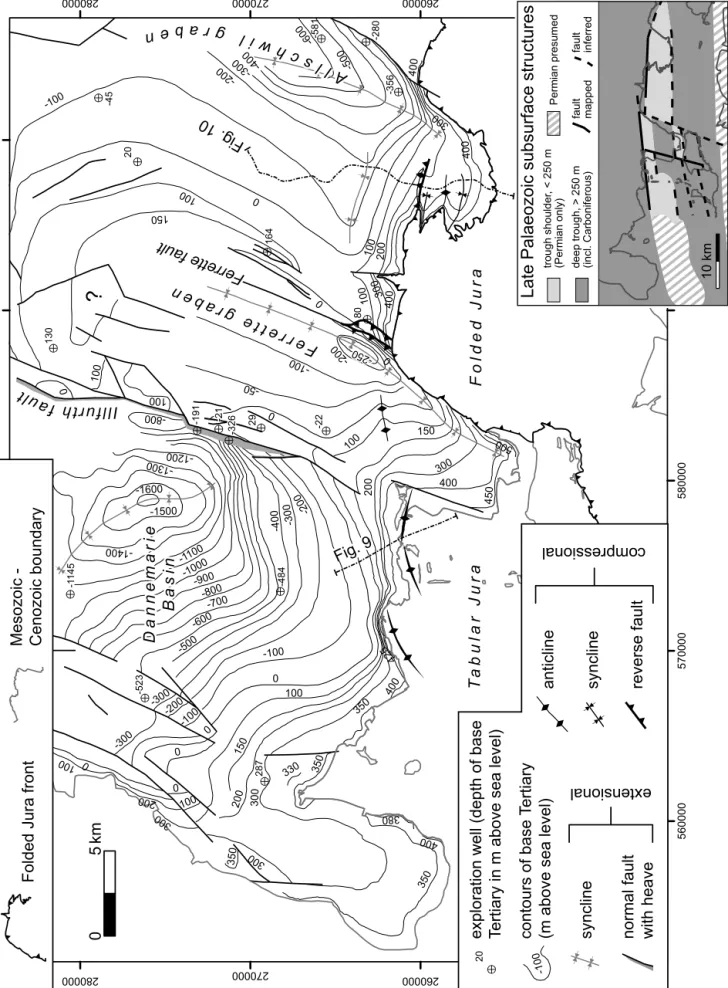
0 200 300 -100 100 150 -50 400 -200 -600 -800 -300 -700 -400 -500 -900 -1100 -1000 350 -1300 -1200 -1400 450 -1500 380 425 500 -250 -250 -250 330 -1600 -300 400 350 300 0 300 0 0 -200 100 400 150 -100 400 -500 100 300 300 200 -200 100 -800 -100 -300 350 400 0 -300 200 -600 100 150 350 -400 100 100 400 0 0 0 100 0 300 -100 100 0 -200 Fig. 8.Contour map of the base Tertiary surface and of the faults dissecting it. Contours are in metres above sea level. The lo
wer right inset shows the known Late Paleozoic structures in the subsurface
In summary, the existence of both restraining and releasing bends along the Illfurth fault hints at left-lateral strike-slip re-activation of the “Rhenish” fault system after the deposition of the Sundgau gravels. We interpret these movements to be con-comitant with the dextrally transpressive reactivation of the ENE-trending faults that are part of the Rhine-Bresse Trans-fer Zone (Giamboni et al. 2004a).
2.3 Is post-2.9 Ma deformation still ongoing at present? The Florimont and Réchésy anticlines are clearly discernible on a shaded relief map, using the Swiss 25m digital terrain model (Figs. 6b, c). The topography of the anticlines essential-ly resulted from folding of Late Jurassic and Paleogene sedi-ments. This can be judged from the close correlation between the strike of the hill slopes and the strike and dip measured in the Upper Jurassic and Paleogene sediments around the two anticlines (Fig. 6c). The contours of the base of the Sundgau gravels (Fig. 6d) also correlate very closely with topography. All this proofs that the topography formed after deposition of the Sundgau gravels, i.e. after 2.9 Ma. Moreover, the river
courses of the Allaine and Coeuvatte are deflected away from the plunging crest of the Florimont anticline (Fig. 6b; Gi-amboni et al. 2004a, their fig. 4b).
Post-2.9 Ma shortening directions derived from paleostress analysis (Ustaszewski & Schmid 2006) are roughly N-S orient-ed in the area of these two anticlines (black arrows in Fig. 6a). This is in agreement with present-day SHmax-orientations in-ferred from in-situ stress measurements in the sedimentary cover (Baumann 1981; Müller et al. 1987; Becker 1999, 2000; Reinecker et al. 2003; Fig. 2).
3 Subsurface evidence for compressively reactivated basement faults
3.1 Contour map of the base of the Tertiary
In order to further investigate the role of pre-existing base-ment faults within the southernmost URG during reactivations in a compressive and/or strike slip regime after Paleogene ex-tension, a contour map of the base-Tertiary surface (“base-Tertiary” for short) and of the faults dissecting this surface was Fig. 9. Reflection seismic line across the Réchésy anticline (modified from Ustaszewski et al. 2005b). See Figures 6 and 8 for location of the section. a. Original stacked section. b. Interpreted section; BM=base Mesozoic, M=top Muschelkalk, L=top Lias, D=top Dogger, T=top Malm or base Tertiary, hatched=fault zone associated with late Paleozoic faults. Base of the Pliocene gravels (de-rived from the contour map, Fig. 3) and topogra-phy are superimposed. The vertical scale is exag-gerated by a factor of 1.2 in order to coincide with the depth in s TWT (calculated using seismic ve-locities from boreholes nearby). Note the correla-tion between the dip of Mesozoic reflectors and the base of the gravels. Fold crests in both gravels and Mesozoic sediments coincide and are located precisely above a basement fault zone.
compiled. 45 industry type reflection seismic lines located in the southernmost URG and the southerly adjacent Tabular and Folded Jura (see bottom centre inset in Fig. 7) were avail-able for interpretation. Ten exploration wells (Schmidt et al. 1924; BRGM unpublished), aligned along or close to the seis-mic lines, enabled a correlation of seisseis-mic reflectors with lithologies encountered in exploration wells. Four of the wells that penetrated through the Tertiary succession allowed calcu-lating seismic interval velocities (Fig. 7). The base of the Ter-tiary succession is marked by high acoustic impedance con-trasts between the uppermost Mesozoic (mostly limestones) and lowermost Tertiary layers (often siderolithic clays). Local-ly, an angular unconformity is developed.
After identification of the base-Tertiary on the seismic lines, its depth (in seconds two-way-travel time, s TWT) was plotted on a map and contoured manually. In a further step, the contours were depth-converted using seismic velocities obtained on the four wells (Fig. 7). In the northwestern part, our base-Tertiary contour map (Fig. 8) was linked to the
structural model of the Dannemarie Basin by Bourgeois et al. (2004). In the southernmost part, the base-Tertiary con-tours are essentially based on the available geological maps (Fischer 1965; Liniger 1970b; Ruhland et al. 1973; Bailly et al. 1985).
The depth of the base-Tertiary is found between 1600 m below sea level in the Dannemarie Basin and 500 m above sea level at the southwestern edge of the Ferrette Jura. The salient feature of Fig. 8 is the existence of three eastward tilted half-grabens, each bounded by a NNE-trending normal fault in the east (Dannemarie, Ferrette and Allschwil grabens). These half-grabens developed gentle hanging-wall synclines, presum-ably due to drag along the bounding normal faults. Towards the Jura front, the base-Tertiary sways into an ENE-WSW to E-W trend along a zone of extensional flexures of the Meso-zoic strata, underlain by Permo-Carboniferous faults (Fig. 8). This structural configuration is the result of Paleogene rifting and serves as a starting configuration for detecting later com-pressive reactivations.
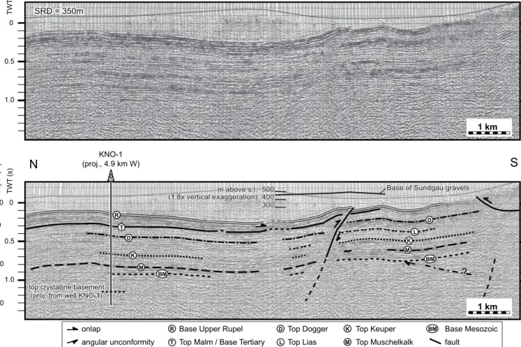
Fig. 10. Reflection seismic line traversing a compressively/transpressively reactivated extensional flexure of Paleogene age. See Fig. 8 for location. Base of the Pliocene gravels (derived from the contour map, Fig. 3) is superimposed in the southern part of the line. Vertical scale is exaggerated by 1.8 in order to coincide with the depth in s TWT in the upper part of the section. Note the correlation between the crest of the reactivated flexure and an anticline at the base of the gra-vels. This suggests that the shortening responsible for the folding of the Pliocene gravels is rooted in the basement.
? TWT (s) 0 0.5 1.0 1 km TWT (s) 0 0.5 1.0 1 km
N
S
onlap Base Upper Rupel
angular unconformity Top Malm / Base Tertiary
Top Dogger Top Muschelkalk Top Keuper Top Lias Base Mesozoic fault T L D M BM R R T D BM L M K SRD = 350m SRD = 350m SRD = 350m KNO-1 (proj., 4.9 km W)
top crystalline basement top crystalline basement (proj. from well KNO-1) (proj. from well KNO-1) top crystalline basement (proj. from well KNO-1)
K 0 +350 -1000 -2000 approx. depth (m) D M K BM 300 300 400 400 500 500 m above s.l. m above s.l. (1.8x vertical exaggeration) (1.8x vertical exaggeration) 300 400 500 m above s.l. (1.8x vertical exaggeration)
Base of Sundgau gravels Base of Sundgau gravels Base of Sundgau gravels
The normal fault bounding the Ferrette half-graben is clear-ly thrust by Mesozoic sediments along the W rim of the Fer-rette Jura (Fig. 8). This is evidenced by boreholes (Schneegans & Théobald 1948) and is interpreted to have occurred during the phase of thin-skinned Jura folding (Ustaszewski & Schmid 2006, their fig. 15). However, immediately N of the northern tip of the Ferrette Jura, the Ferrette normal fault itself was re-activated. This is evidenced by two top-to-the-E reverse faults that splay off the Ferrette normal fault and which offset the base-Tertiary in seismic sections (see Ustaszewski et al. 2005b, their fig. 6). Since the splay faults dissect uppermost Rupélian and Chattian sediments, reactivation must have occurred after the Oligocene. On the other hand, the Sundgau gravel cover does not show any difference in elevation across these fault splays (compare Figs. 3 and 8). Hence the reactivation of this fault pre-dates the deposition of the Sundgau gravels. More-over, the thin-skinned frontal thrust of the Ferrette Jura front appears to “seal” these compressive fault splays of the Ferrette fault. This hints at an Early Neogene reactivation, pre-dating the formation of the thin-skinned Jura fold-and-thrust belt.
At the eastern termination of the Ferrette Jura, the E-W-trending anticlines plunge beneath the Tertiary infill of a small embayment of the URG that encroaches onto the Jura. At the southern limb of the northernmost of these gentle anticlines, a top-to-the-S reverse fault was mapped (Fischer 1965 and Fig. 8). This vergence is opposed to the transport direction of the detached sediments during the thin-skinned phase of Jura fold-ing. As will be discussed below when presenting seismic evi-dence, this reverse fault post-dates the deposition of the Sundgau gravels and roots in the basement.
3.2 Evidence from reflection seismic lines
The compressive structures portrayed in Fig. 8 will now be dis-cussed on the basis of reflection seismic data. The reflection seismic line across the Réchésy anticline (Fig. 9) complements another seismic line from the same area, crossing the westerly adjacent Florimont anticline (see Giamboni et al. 2004a, their fig. 7). The Réchésy anticline has a precursor as a Paleogene extensional flexure, documented by the S-ward tapering and onlap of Paleogene syn-rift sediments (Ustaszewski et al. 2005b). From the topography and the superimposed trend of the base of the Sundgau gravels (derived from Fig. 3), it is dis-cernible that the topographic crest, the crest in the Sundgau gravel fold and the position of a relatively transparent base-ment fault zone (or high) underlying the Mesozoic succession all spatially coincide. This seismic evidence, together with that provided by Giamboni et al. (2004a), indicates that Paleogene-age extensional flexures have been compressively or transpres-sively reactivated after 2.9 Ma. Giamboni et al. (2004a) provid-ed arguments that indicate reactivation of the basement fault itself. However, since a merely passive role of this basement fault zone depicted in Fig. 9 (and of that depicted in Giamboni et al. 2004a, their fig. 7) during a N-ward propagation of dé-collement tectonics across the formerly extensional flexure cannot be completely excluded, this issue needs to be further discussed together with additional seismic data presented below.
This additional reflection seismic line, trending approxi-mately N-S along the Allschwil half-graben (Fig. 10, see Fig. 11 for a geological interpretation), provides unambiguous evi-Fig. 11. Schematic geological cross section based on the reflection seismic line shown in evi-Fig. 10, illustrating a possible link between the compressive/transpressi-ve reactivation of an E-W-trending Paleogene extensional flexure and the incipient incompressive/transpressi-version of an underlying Permo-Carboniferous trough.
S
N
0 m +500 m -1000 m -2000 m -3000 m approx. depth (m) Folded Jura U p p e r R h i n e G r a b e n Permian and / or Carboniferous crystalline basement Mesozoic, autochthonous Mesozoic, detached Base of Upper Rupelian (Foraminifera marl,Fischschiefer, Meeressand) Upper Priabon - Lower Rupel ("Salt Formation")
Upper Rupel ("Serie grise") Chatt and Upper Pliocene
To p M u s c h e l k a l k TWT (s) 0 0.5 1.0 2.0 1.5 TWT (s) 0 0.5 1.0 2.0 1.5 1 km KNO-1 (proj., 4.9 km W) Top crystalline Top crystalline (proj. from well KNO-1) (proj. from well KNO-1)
Top crystalline (proj. from well KNO-1)
dence for basement-rooted neotectonic shortening. The south-ern end of the seismic line covers the Tertiary embayment east of the Ferrette Jura (Allschwil Graben). The Mesozoic succes-sion reveals a constant thickness and gently rises in elevation from N to S. A steeply N-dipping basement fault offsets the base of the Tertiary at about 0.1 s TWT, corresponding to c. 80-100 m depth. The Mesozoic succession was bent into an ex-tensional flexure above this basement fault. The thickness of the Mesozoic succession is slightly lower on the hangingwall-side (i.e. the S hangingwall-side) of the flexure when compared to the rest of the section. This extensional flexure was later covered by the onlapping Upper Priabonian to Lower Rupelian fill of the URG (between reflectors “T” and “R”) that wedges out to-wards the S. The weakly reflective to transparent parts above the “R” reflector are attributed to Uppermost Rupelian to
Chattian syn-rift sediments and the unconformably overlying Sundgau gravels. The extensional flexure was compressively reactivated by the top-to-the-S reverse fault that offsets the prominent Upper Rupelian reflector (Figs. 10 & 11). The throw amounts to 0.05 s TWT, corresponding to some 40–50 m, given the seismic interval velocities valid for the Upper Oligocene syn-rift succession (Fig. 7). Based on the seismic in-formation alone, this compressive (or transpressive) fault reac-tivation could have already occurred during latest Paleogene to Miocene times. However, note that the anticline in the hangingwall of this top-to-the-S reverse fault spatially coin-cides with an anticline defined by the contour lines of the base of the Sundgau gravels (compare Figs. 3 and 8). Moreover, the amplitude of the anticline contoured in Fig. 3 is identical to that detected in the seismic section (in the order of 30–50 m, Fig. 12. Top: Late Paleozoic structures in the Rhine-Bresse Transfer Zone (RBTZ), superim-posed onto the outlines of the major tectonic ele-ments. BG = Bresse Graben, URG = Upper Rhine Graben. Bottom: location of the epicentre of the Rigney earthquake (Swiss Seismological Service 2004) and contours of epicentral intensity on the French territory (RéNaSS 2004), which are ellipsoidal with the long axis paralleling ENE-ori-ented subsurface faults. Map traces of faults rea-ching the surface (see top figure for subsurface faults) are shown in black. The focal mechanism (Swiss Seismological Service 2004; bottom right inset) is reverse faulting. Note that the ENE-tren-ding, SE-dipping nodal plane (labelled “PCT” for Permo-Carboniferous trough) is again parallel to major subsurface basement faults in the epicen-tral area. ? ? ? ? ? ? Basel Black Forest E 0 25 50 km U R G B G Mo l a ss e B as i n Basel Dijon Alps Fo ld ed Ju r a Fo ld ed Ju r a Black Forest R B T Z R B T Z Rigney, 23. 02. 2004 Basel Vosges Black Forest U R G U R G B G Mo l a ss e B as i n Alps Fo ld ed Ju r a Mo l a ss e B as i n Basel Dijon Vosges Alps Fo ld ed Ju r a Black Forest R B T Z R B T Z
PCT
Late Palaeozoic subsurface structures deep trough, > 250 m (incl. Carboniferous) Permian presumed trough shoulder, < 250 m (Permian only) basement fault mapped, certain basement fault inferred, presumed V IV III Rigney, 23. 02. 2004 Mw contour of epi-central intensity Vosges Vosges 0 25 50 km =4.5, z=15 kmsee Figs. 10 and 11). Hence, we infer a post-2.9 Ma age for the compressional inversion of a pre-existing, roughly E-W trend-ing basement fault. This fault is part of an ENE-WSW-trend-ing pre-existENE-WSW-trend-ing basement fault system within the Pre-Meso-zoic basement (Permo-Carboniferous trough system), transtensionally reactivated by the Rhine-Bresse Transfer Zone in Paleogene times (Ustaszewski et al. 2005a,b).
4 Discussion
4.1 Comparison of paleostress measurements with data on the present-day stress field
The recent stress field in the sedimentary (Mesozoic to Ter-tiary) cover, as revealed by in-situ stress measurements, reveals NNW- over N- to NNE-oriented maximum horizontal stresses (SHmax, Figs. 2 and 3; see also Becker 1999, 2000). This spread in orientations within the cover rocks coincides with that of the shortening directions obtained from paleostress analysis (Fig. 2, see also Ustaszewski & Schmid 2006), particularly in the area of the Folded Jura. Hence, no detectable reorientation of SHmax had occurred within the cover rocks since the onset of thin-skinned Jura folding (in agreement with data provided by Becker 2000 and Müller et al. 2002).
However, at greater depth, i.e. within the basement of both URG and the Jura Mountains the direction of present-day SHmax, as derived from seismic events, is consistently NW-SE-oriented (Plenefisch & Bonjer 1997; Kastrup et al. 2004). Note that the present-day dextrally transpressive reactivation of the Rhine-Bresse Transfer Zone system, as inferred from this study and Giamboni et al. (2004a), also demands a pre-sent-day orientation of SHmax close to NW within the base-ment.
All this implies an anticlockwise rotation of present-day SHmax from cover to basement. Interestingly such stress de-coupling is found to be systematic throughout northern Switzerland (Müller et al. 1987). It clearly indicates ongoing mechanical decoupling of the sedimentary cover from its base-ment along Mid- to Late Triassic weak layers. Whether such decoupling indeed indicates ongoing thin-skinned propagation of the Jura Mountains, as proposed by Müller et al. (2002), is another question. In view of the evidence provided in favour of thick-skinned tectonics we do not regard such decoupling between basement and cover as a solid argument for presently ongoing thin-skinned tectonics. Dynamically scaled sand-sili-cone models have demonstrated that low displacement rates along basement strike-slip faults also favour mechanical de-coupling between basement and cover across a viscous weak décollement layer (Ustaszewski et al. 2005a). Given the low displacement rates that prevailed since the latest Pliocene, de-coupling is also expected in a thick-skinned scenario according to these experiments.
We conclude that present-day deformation is thick-skinned and that the stress field is probably inhomogeneous, SHmax being NW-SE-oriented in the basement, but N-S in the cover.
4.2 Kinematic framework of neotectonic activity in the southern URG
The geometry of neotectonic deformations recorded by the stratigraphic base of the Sundgau gravels reveals an array of NE-SW- to ENE-WSW-oriented syn- and anticlines with am-plitudes up to 150 m. Retro-deformation of the anticlines yields amounts of shortening in the order of 1 to 3%. Assum-ing shortenAssum-ing to have occurred between 2.9 Ma and the pre-sent day, this yields minimum horizontal displacement rates in the order of 0.05 mm/a, corresponding to a strain rate in the order of 2·10-16s-1 across the folded area. This value is in agree-ment with strain rates calculated from GPS-derived velocities that are in the order of 4·10-16s-1(Tesauro et al. 2005, their fig. 3).
The evidence for sinistral strike-slip faulting along NNE-trending faults (such as the Illfurth fault) after the latest Pliocene suggests that some folds that affect the base of the Sundgau gravels did form by sinistral wrench faulting.
The formation of the Florimont and Réchésy anticlines (Giamboni et al. 2004a and this work) and the backthrust formed further to the east (Figs. 10 & 11), in combination with ample geomorphologic evidence, suggests that at least much of the shortening across the ENE-WSW-trending basement faults of the Rhine-Bresse Transfer Zone occurred after depo-sition of the Sundgau gravels. The en-échelon arrangement of all the anticlines (Fig. 3), in combination with seismic evidence (Giamboni et al. 2004, their fig. 7; our Figs. 10 & 11) favours the interpretation that this neotectonic shortening detected in the cover is caused by dextrally transpressive reactivation of the ENE-WSW-trending basement fault system of the Rhine-Bresse Transfer Zone. The reverse fault portrayed in Fig. 10 is basement-rooted, which excludes the possibility that the com-pressive reactivation of the flexure is related to the ongoing N-ward propagation of a décollement in the Triassic weak layers. In our opinion the profile of Fig. 10 represents the best evi-dence available so far in favour of a transition from thin-skinned to thick-thin-skinned deformation, which we infer to have occurred before the latest Pliocene.
The kinematic setting we propose for the neotectonic ac-tivity resembles that first proposed by Pavoni (1961) for the main phase of Jura folding; folding of the sedimentary cover may be linked to wrench faulting within a buried basement, provided that a ductile layer separates basement and cover. Such a layer is indeed provided by the Triassic evaporite hori-zons in the Jura Mountains and adjacent areas. Note, howev-er, that we regard this scenario as a viable one only regarding the ongoing thick-skinned tectonic activity in the NW-fore-land of the Alps (and not for the main phase of thin-skinned Jura folding).
Interestingly, the neotectonic reactivation of the Ferrette fault occurred where it interferes with the ENE-trending base-ment faults of the Rhine-Bresse Transfer Zone. This suggests that neotectonic shortening concentrated in an area where the NNE-trending sinistral reactivations interfere with
concomi-tant dextrally transpressive reactivations along ENE-trending basement faults.
However, there is also evidence for pre-Late Pliocene compressive reactivation of the Rhine-Bresse Transfer Zone. An ENE-trending small anticline, identified in a seismic sec-tion presented by Ustaszewski et al. (2005a, their fig. 3), is lo-cated immediately W of the compressive splays of the Ferrette fault. This anticline formed along-strike with the Florimont and Réchésy anticlines, as well as the thrust depicted in Figs. 10 & 11 (see Fig. 8 for the location of all these compressive features). According to the seismic information, a purely post-2.9 Ma age is unlikely, because the Sundgau gravel base re-veals no upwarping above this particular anticline (compare Figs. 3 and 8). A first episode of dextrally transpressive reacti-vation of the underlying ENE-trending Rhine-Bresse Transfer Zone is likely to have predated the deposition of the Sundgau gravels. It probably pre-dated thin-skinned Jura tectonics and was possibly coeval with some sinistral reactivation of NNE-trending normal faults such as the Ferrette normal fault. In-terestingly, such a first episode of compressive reactivation of URG-parallel basement faults was postulated by Laubscher (2001) to have occurred in Aquitanian to Burdigalian times in the case of Rheintal flexure located east of our working area. Moreover, on the seismic line portrayed in Fig. 9 one can de-pict that the S-dip of the Mesozoic reflectors at the southern limb of the anticline is slightly higher than the corresponding dip of the base of the Sundgau gravels. This suggests that an embryonic form of this anticline already formed prior to the folding of the Sundgau gravels. Hence, not all the shortening and uplift above the Rhine-Bresse Transfer Zone is of latest Pliocene to recent age. Unfortunately no continuous gravel sheet is preserved on top of the two above mentioned anti-clines in order to quantify the amounts of Early Neogene ver-sus neotectonic reactivation. However, the present geometry of the features presented in Figs. 10 & 11 was essentially achieved during the second (neotectonic) phase of transpres-sive reactivation.
We conclude that the ENE-trending basement-rooted faults located at the southern end of the URG, related to the Rhine-Bresse Transfer Zone, appear to have been reactivated twice under compression in the Neogene. A first reactivation probably occurred in the early Neogene and pre-dated thin-skinned Jura folding. The second and main phase of reactiva-tion of ENE- to E-trending basement faults, however, post-dates the deposition of the Sundgau gravels. This neotectonic activity is evidenced via the spatial coincidence between base-ment faults and folds mapped in both the base-Tertiary and base-Sundgau gravel maps, and additionally, by comparable fold amplitudes seen in both the Tertiary and the base-Sundgau gravel surfaces.
The evidence for simultaneous neotectonic left-lateral strike-slip faulting along the NNE-trending Rhenish faults is in good agreement with seismotectonic evidence (Plenefisch & Bonjer 1997; Deichmann et al. 2000a) that was mostly collect-ed east of our working area. The coeval latest Pliocene to
re-cent dextrally transpressive reactivation of the ENE-trending faults of the Rhine-Bresse Transfer Zone, as inferred from the present work, however, is hitherto supported almost exclusive-ly by geological evidence (Meyer et al. 1994; Giamboni et al. 2004a; Ustaszewski et al. 2005a). The seismotectonic evidence supporting the reactivation of such ENE-trending faults is scarce in the area west of Basel, at least partly due to the lack of a dense network of permanent stations on French territory. Nevertheless, the February 02nd2004 earthquake in the Rhine-Bresse Transfer Zone near Rigney (France), with a moment magnitude Mw=4.5 and a focal depth of 15 km, yielded a focal mechanism which indicates reverse faulting (Swiss Seismologi-cal Service 2004; Fig. 12). Although it is not admissible to as-sign one of the nodal planes to the actual fault plane without carefully analysing aftershocks, clear preference is given to the ENE-oriented and SE-dipping nodal plane labelled “PCT” in Fig. 12 because of the fact that ENE-trending basement faults related to the Permo-Carboniferous trough are abundant in this area. These faults are part of the Rhine-Bresse Transfer Zone (Debrand-Passard & Courbouleix 1984). Thus, the focal mechanism of the Rigney earthquake can be regarded as seis-motectonic evidence for the compressive inversion of Permo-Carboniferous troughs in the northern Alpine foreland, com-patible with dextral transpression along the Rhine-Bresse Transfer Zone as deduced from our data.
There are still more hints at dextrally transpressive neotec-tonic activity in the western part of the Rhine Bresse Transfer Zone. Based on reflection seismic data, Madritsch et al. (2007) reported the transpressive inversion of steep ENE-trending Paleozoic basement faults along the western part of the Avant-Monts thrust, NW of Besançon. Surface structures associated with these inverted faults are gentle anticlines in the hanging-wall of the Avant-Monts thrust. Uplift along these anticlines causes a northward deflection of the Ognon river, which flows immediately north of the Avant-Monts thrust, and the subse-quent erosion of its presumably Pleistocene aggradational ter-races (Campy 1984; Madritsch et al. 2005). These data seem thus in agreement with seismotectonic evidence from the Rigney 2004 event, concerning the neotectonic inversion of Permo-Carboniferous trough border faults.
Inversion of Permo-Carboniferous troughs is also compati-ble with ideas proposed by Ziegler (1990), Philippe (1994) and Pfiffner et al. (1997) for other parts of the NW foreland of the Alps located south of our working area. Note, however, that these authors proposed such thick-skinned reactivation for the main phase of Jura folding, that we consider as purely thin-skinned. We postulate a thick-skinned kinematic framework only for neotectonic deformation, with a weak precursor in the Early Miocene, i.e. before the main phase of the thin-skinned formation of the Jura fold-and-thrust belt.
In case of the ENE-trending Mandach thrust in the eastern Tabular Jura (“M” in Fig. 1), located about 70 km east of our working area, but exactly along-strike above the eastern con-tinuation of the Permo-Carboniferous trough, thick-skinned compressive neotectonic reactivation should at least not be
ruled out. According to most authors (Müller et al. 1984; Laubscher 1986; Sprecher & Müller 1986; Diebold et al. 1991; Naef et al. 1995), the Mandach structure has initiated as an ex-tensional flexure above the northern border fault of the Permo-Carboniferous trough, which later led to the nucleation of a thin-skinned, N-vergent thrust fault, concomitant with the formation of the Folded Jura further S.
Haldimann et al. (1984) identified an ENE-trending ridge of easily erodible Aalenian clays underneath Pleistocene grav-els along the Aare river in the eastern along-strike prolonga-tion of the Mandach thrust. Haldimann (1987) treated the exis-tence of this ridge as evidence for late Pleistocene uplift of the southern hangingwall along the Mandach thrust. Graf (1993) argued for an eastward deflection of N-flowing Alpine rivers at the time of deposition of the “Höhere Deckenschotter”. Based on paleoflow directions in a Pleistocene gravel sheet near Mandach, he related this deflection to uplift of the southern hangingwall along the Mandach thrust fault. In addition to this, precise levelling data indicate uplift of the “Vorfal-tenzone” (i.e. the region between Mandach thrust and souther-ly adjacent thrust front of the Folded Jura; Müller et al. 2002). This led Müller et al. (2002) to consider the Mandach thrust as the northern tip of the “distant-push” front of the Folded Jura, which has remained active up to recent. However, as the thin-skinned Mandach thrust is situated above the border fault of the Permo-Carboniferous trough (as is the case for the struc-tures in the Rhine-Bresse Transfer Zone further W), neotec-tonic inversion of an underlying ENE-trending basement faults itself should not be completely ruled out, despite the lack of seismotectonic evidence for compressive reactivation in this area.
The seismotectonic evidence available for the area NE of Basel favours neotectonic reactivation of basement faults by strike slip and/or transtension (Plenefisch & Bonjer 1997; De-ichmann et al. 2000a; Kastrup et al. 2004). Hence the infer-ences regarding a transpressive neotectonic kinematic frame-work for our frame-working area, located west of Basel, certainly do not apply to the area of the Black Forest and the eastern bor-der fault of the URG.
In summary, and coming back to our area of investigation, the available geological evidence clearly shows that both the NNE-trending Rhenish faults and the ENE-trending basement
faults of the Rhine-Bresse Transfer Zone were coevally reacti-vated during latest Pliocene to recent times. NNE-trending faults are reactivated in left-lateral strike-slip mode, the ENE-trending faults in dextrally transpressive strike-slip mode (oc-casionally thrusting as is the case for the 2004 Rigney earth-quake).
4.3 Which fault produced the Basel 1356 earthquake?
The NW-SE-orientation of SHmax of the present-day stress field at depth appears well documented both by the interpreta-tion of geological data such as that presented here and by seis-motectonic evidence compiled by Kastrup et al. (2004). To-gether with our present knowledge regarding the orientation of pre-existing faults, this puts certain constraints as to which pre-existing fault might have been reactivated in which mode during the 1356 Basel earthquake. In view of the crucial im-portance of the high-magnitude Basel earthquake for seismic hazard evaluations, the quality of such evaluations critically depends on solving this difficult question.
Three sets of faults are prone to reactivation in the Basel area (Deichmann et al. 2004b). We argued that the NNE-striking Rhenish faults and the ENE-NNE-striking faults of the Rhine-Bresse Transfer Zone, which continue east of Basel into the Northern Swiss Permo-Carboniferous trough (e.g. Diebold & Noack 1997; see also Ustaszewski et al. 2005b, their fig. 2), are presently active in terms of sinistral strike slip and dextrally transpressive movements, respectively. A third family of WNW-ESE-striking faults is found east of Basel only (see Fig. 12 top) and appears to be presently ac-tive there, as is for example suggested by fault plane solu-tions of the 1999 Pratteln and 2003 Zeiningen events (Deich-mann et al. 2000b, 2004a), which are indicative for dextral strike slip reactivation. Although these WNW-ESE-striking faults are obviously active, their limited length on a geo-logical map (<40km) appears to be insufficient for creating the surface rupture length necessary for an earthquake with magnitude 6.5 or higher (Wells & Coppersmith 1994; Deichmann et al. 2004b).
The data available so far do not allow to clearly decide be-tween faults related to the ENE-striking Rhine-Bresse Trans-fer Zone (including its eastern continuation, the Northern Fig. 13. Kinematic sketch proposed for the neo-tectonic activity in the study area. The Rhine-Bresse Transfer Zone (RBTZ) is under dextral transpression, causing subsequent uplift (“+”) due to the presumed inversion of ENE-trending Permo-Carboniferous troughs. En-échelon surfa-ce folds develop above ENE-trending basement faults. Simultaneously, NNE-trending faults of the URG-system are active as sinistral strike-slip faults. Transpressive fault splays or pop-ups deve-lop at the intersection of the two differently ori-ented fault systems.
BG
URG
R B TZ
Swiss Permo-Carboniferous trough) on the one hand and NNE-striking Rhenish faults on the other hand. Conspicuous-ly, the epicentre of the 1356 Basel earthquake immediately south of Basel is located near the intersection of the two fault sets, suggesting mutual interactions between those two simul-taneously active fault systems, such as was described above for the area west of Basel.
Both fault systems have been proposed as having pro-voked the 1356 Basel earthquake. Meyer et al. (1994) and Laubscher (2006) favour the Rhine-Bresse Transfer Zone, mainly based on the E-W elongated shape of the zones of equal damage (Mayer-Rosa & Cadiot 1979). They left it open as to whether this fault system was reactivated in dextral strike slip or thrust mode. Answering this question would de-mand knowledge of the ratio and orientation of the principal stresses such as can be obtained through inversion of fault plane solutions for seismic events. So far such data (Kastrup et al. 2004) are only available for the areas north of Basel (strike slip mode) and south of Basel (combination of strike slip and normal faulting). Our evidence for dextral transpres-sion along the Rhine-Bresse Transfer Zone west and south-west of Basel, together with the fault plane solution of the Rigney 2004 earthquake, rather suggests a combination of strike slip and thrusting for the present-day stress field in the area west of Basel, a stress field that might also have triggered the 1356 Basel earthquake. In view of the relatively larger strain accumulation we detected above faults related to the Rhine-Bresse Transfer Zone system regarding latest Pliocene to recent deformations, we favour the hypothesis that it is this fault system, which was activated, in agreement with the ideas proposed by Meyer et al. (1994) and Laubscher (2006). The most probable mode of reactivation is dextral transpression (Fig. 13).
On the other hand, we cannot exclude reactivation of one of the NNE-striking Rhenish faults during the 1356 Basel event in sinistral strike slip mode. However, we agree with Laubscher (2006) that the evidence for a reactivation of a Rhenish fault in extensional mode during the Basel earth-quake (the so-called “Reinach fault”) provided by Meghraoui et al. (2001) and Ferry et al. (2005) is incompatible with our knowledge about the present-day stress field. As pointed out by Laubscher (2006) the evidence provided by Meghraoui et al. (2001) and Ferry et al. (2005) for the “Reinach fault” being an active seismogenic fault is far from convincing. The geo-morphological features found in the surroundings of the “Reinach fault” rather indicate that gravitational sliding was responsible for the “faults” documented by the trenching (Ferry et al. 2005).
In conclusion, a dextrally transpressive reactivation of a fault that is part of the ENE-striking Rhine-Bresse Transfer Zone is a possible candidate for having caused the 1356 Basel earthquake (Fig. 13). Reactivation of a NNE-striking Rhenish fault cannot be excluded. However, such a reactivation would be expected in sinistral strike slip rather than normal fault mode.
4.4 What induced the change from thin-skinned to thick-skinned deformation in the Late Pliocene?
Our data, together with those presented by Giamboni et al. (2004a), Ustaszewski et al. (2005a) and Ustaszewski & Schmid (2006) provide compelling evidence for basement-rooted fault reactivation to have followed Late Miocene to Early Pliocene thin-skinned folding and thrusting. Thick-skinned reactivation is particularly well documented in an ENE-trending belt of basement faults that delineate the Permo-Carboniferous graben system in the subsurface, roughly paralleling the northern front of the eastern Jura Mountains (see top of Fig. 12, and Ustaszewski et al. 2005b, their fig. 2). The data suggest that this transition is linked to the incipient inversion of these grabens. This implies that shortening within the pre-Mesozoic basement, which took place within the Alps during classical Jura folding (“Fernschub” or “distant push” theory in the sense of Laubscher 1961), migrated northwards into the Alpine foreland during the Late Pliocene. Based on evidence from reflection seismic profiles and cross section balancing considerations, inversion of Permo-Carboniferous grabens during a late stage or, alternatively, post-dating thin-skinned Jura folding and thrusting, was also invoked for the basement underneath the western Jura belt (Philippe 1994; Philippe et al. 1996). In the following, we speculate on the reasons that might have led to this transition from thin-skinned tectonics to basement-rooted deformation. Two possibilities are briefly outlined: (1) deactivation of intra-crystalline glide along the basal décollement, and (2) ongoing tectonic underplating in the foreland of the northwestern Alps (Mosar 1999).
(1) The theory that décollement in the Jura fold- and thrust belt occurred by viscous flow, i.e. processes such as intracrys-talline glide within the Mid- and Upper Triassic halite and an-hydrite layers, is rheologically viable and widely accepted nowadays (Laubscher 1961; Müller & Briegel 1980; Jordan 1987). Intracrystalline glide processes in some of the evapor-ites may be activated at very low temperatures that are equiva-lent to an overburden column in the order of 1 km. Based on apatite fission track data, 1-3 km of uplift and erosion of the entire Swiss Molasse Basin after 5 Ma BP were recently docu-mented (Cederbom et al. 2004). According to these authors, the uplift was triggered by accelerated erosion in the Swiss Alps in response to increased precipitation rates, leading to the isostatic rebound of the Alps together with the northerly adja-cent foreland basin. This high amount of erosion in the north-ern Molasse Basin may have caused the sedimentary overbur-den (and, hence, the temperature) to fall beneath a critical threshold necessary to keep intracrystalline glide systems in the basal Jura décollement active. The inferred timing of the uplift slightly predates the onset of sedimentation of the Pliocene Sundgau gravels at 4.2 Ma ago, which, in turn, is thought to be the latest possible time at which thin-skinned folding in the Northern Jura Mountains has come to a halt (Becker, 2000; Ustaszewski & Schmid 2006). These timing con-straints allow a causal relationship between rebound-triggered