University of Neuchâtel Centre for Hydrogeology
Faculty of Science and Geothermics
Ph.D. Thesis
Investigation of Groundwater-Surface Water
Interactions with Distributed Temperature Sensing
(DTS)
presented to the Faculty of Science of the University of Neuchâtel to satisfy the
requirements of the degree Doctor of Philosophy in Science
by
Anne-Marie Kurth
(born 25.01.1984 in Freiburg im Breisgau/Germany)
Thesis defence date: 11. December 2014 Public presentation date:
Ph.D. Thesis evaluation committee:
Prof. Dr. Mario Schirmer, University of Neuchâtel (Director of the thesis) Prof. Dr. Daniel Hunkeler, University of Neuchâtel (Co-Director of the thesis) Prof. Dr. Philip Brunner, University of Neuchâtel
Faculté des sciences Secrétariat-décanat de Faculté Rue Emile-Argand 11 2000 Neuchâtel - Suisse Tél: + 41 (0)32 718 2100 E-mail: [email protected]
IMPRIMATUR POUR THESE DE DOCTORAT
La Faculté des sciences de l'Université de Neuchâtel
autorise l'impression de la présente thèse soutenue par
Madame Anne-Marie KURTH
Titre:
“Investigation of groundwater-surface water
interactions with distributed temperature
sensing (DTS)”
sur le rapport des membres du jury composé comme suit:
- Prof. ass. Mario Schirmer, Université de Neuchâtel, directeur de thèse - Prof. Daniel Hunkeler, co-directeur de thèse, Université de Neuchâtel - Prof. Philip Brunner, Université de Neuchâtel
- Prof. John Molson, Université de Laval, Québec, Canada
Neuchâtel, le 8 janvier 2015 Le Doyen, Prof. B. Colbois
“... all that we need to make us really happy is something to be enthusiastic about.” Charles Kingsley
Thank you to...
... Mario Schirmer for his supervision, his absolute trust and support under all circumstances. He provided conditions in which I could totally focus on my research without having to worry about anything. He was always available and open for discussions, always ready for helpful advice. Furthermore, I will never forget the wisdom of the fairy tale of “The Ship with the Crimson Sail” he told me as an introduction to his group.
... Daniel Hunkeler, who made this Ph.D. possible in the first place.
... Gunnar Nützmann and Klement Tockner from the IGB Berlin, who let me be part of their AQUALINK International Leibniz Graduate School.
... John Molson, who agreed to be my external examiner, and who had such great ideas on how to get the most out of my data.
... Philip Brunner for providing me with a super field site and for all the stimulating discussions.
... Oliver Schilling for the great collaboration and all the good times we had in the field, digging in cables and digging out cars stuck in the mud.
... Christine Weber for asking critical questions, for all the times she spent on reading through my manuscripts, providing tons of helpful comments, for teaching me how to create interesting publications and for being a great co-author.
... Silvio Harndt for his technical support with the ADTSS, for teaching me computer tricks, for answering endless questions how this and that technical device works and for making sure that I don’t accidentally electrocute myself or others with the ADTSS.
... Nick Dawes for his collaboration and support with the computation of the ADTSS.
... John Selker, Nick van de Giesen, Stijn de Jong and Olivier Hoes for helpful information and tips regarding the DTS.
... Andy Raffainer, Kay Fries, Seba Soldo, Peter Gäumann, and Richard Fankhauser for their technical support and for assisting me in the field, even donning their waterproofs to join me in the water at -10 °C.
... Thomas Lichtensteiger for his support in all matters Chriesbach restoration, for helping me with tricky concessions and for being such a dedicated ECO-team leader.
... the previous and current members of the Hydrogeology Group: Ben, Christian, Dirk,
Elham, Jana, Mehdi, Sämy, Stefano, Tobi, and Vidhya. Thanks for all the discussions, field
support and fun that we had.
... RoKi’s group: RoKi for exciting excursions into the realms of physics; Lina and Simon for the great time we had teaching the USYS students in the physics practicals (now we know that bananas frozen in liquid nitrogen smash into a thousand pieces when accidentally dropped and that frozen satsumas are too hard to be eaten); Matthias for joining me in the adventure of Radon analysis; and Ola and Ryan for all the tea and coffee breaks and chats in the mornings.
... Anna-Marie, Cecille, Christian, Franziska, Maria, Max and Nina from AQUALINK for the stimulating and fruitful discussions and the great times we had at the AQUALINK meetings and the EGU.
... Janet Hering for creating such an ideal research climate in which collaborations and friendly exchange between research groups prevail.
... David Lerner and Steve Thornton from Sheffield University for teaching me to work so efficiently that I could finish a 100 % Ph.D. in 60 % of the time.
... everyone outside Eawag who supported me throughout my Ph.D. time and made this all possible.
... my friends, for supporting me through ups and downs, for endless walks, chess games, dinner parties, video nights, and music sessions in which I could forget the struggles of Ph.D. life for a while.
And last but not least:
... my family, Moni and Holgi, Caro, Eike, Pablo and Zoé, and Grossmütterle for their unconditional love and support, in reading all the theses between Bachelor and Ph.D., for sharing joy and sorrow, for great times together and for always being there for me.
Abstract
Groundwater-surface water interactions are a vital necessity for aquatic ecosystems as they control the water temperature, the availability of nutrients, dissolved oxygen and the water quality in the hyporheic zone. A lack of groundwater-surface water interactions may result in the deterioration of ecosystem health and functioning. Studies between 1997 and 2008 have shown that 22 % of Swiss water courses were severely degraded, e.g. engineered or covered. As a consequence, river restoration was made a legal obligation, stipulating the restoration of 4000 km of degraded rivers and streams over the course of the next 80 years. For this thesis a review of Swiss river restoration data between 1979 and 2012 for 13 of the 26 Swiss cantons was performed. Results indicated that restoration activities had steadily increased since 1979, with an average restoration rate of 9.8 km/year. An analysis of the restoration techniques revealed interesting geographical trends. In western Switzerland, more sustainable combinations of restoration measures, such as bioengineering or water quality improvements, were favoured. Cantons in central and eastern Switzerland, on the other hand, preferred single restoration measures with a higher degree of mechanical intervention. In general, the evaluation of restoration effects was only reported for less than 10 % of all investigated restoration projects. These mainly focussed on the number of flagship species, such as trout. None of the investigated projects tested whether river restoration had re-established groundwater-surface water interactions. Hence, this thesis aims at investigating the effects of river restorations on groundwater-surface water interactions. A number of techniques are commonly used to investigate groundwater-surface water interactions, including geochemical, hydrogeological and physical approaches. In the present study a combination of approaches is employed, with the main focus being on the physical parameter of water temperature. The latter is investigated with Distributed Temperature Sensing (DTS). DTS is used to measure temperature differences between ground- and surface water in surface water bodies. So far, the existing DTS methods have enabled the investigation of groundwater-surface water interactions under gaining conditions in small brooks. In order to investigate the effect of river restoration on groundwater-surface water interactions, however, a method applicable in both gaining and losing conditions, and which is suitable for water courses of all sizes is required. For this purpose, a new methodology, the PAB approach, has been developed, which combines passive (P) and active (A) DTS methods with the burying (B) of the fibre-optic cable in the subsurface. This approach enables long-term distributed investigations of groundwater-surface water interactions under gaining and losing conditions in water courses of all sizes. The active DTS method in the PAB approach, however, requires the direct
presence of an operator controlling the heating of the fibre-optic cable. In order to circumvent this limitation and enable long-term temperature measurements with the PAB approach in remote areas, an autonomous DTS system (ADTS system) has been developed. This system combines several advantages, such as remote control, automated data transfer, and automated heating. By aid of the ADTS system and the PAB approach, the effect of river restoration on groundwater-surface water interactions has been investigated in an urban stream. Results indicate that the installation of gravel islands increased the rate of surface water downwelling. Generalising the results, it may be assumed that such changes to river morphology will have a positive effect on the rate of groundwater-surface water interactions. Therefore, river restoration may be successful in enhancing groundwater-surface water interactions. Concerning the newly-developed DTS method and measurement system, it could be shown that the combination of the ADTS system and the PAB approach is a powerful tool for the investigation of groundwater-surface water interactions. In future river restoration projects, this tool should be employed for evaluating its success in re-establishing groundwater-surface water interactions.
Zusammenfassung
Grundwasser-Oberflächenwasser-Interaktionen sind eine notwendige Voraussetzung für gesunde aquatische Ökosysteme, da diese die Verfügbarkeit von Nährstoffen und gelöstem Sauerstoff, aber auch die Wassertemperatur und –qualität in der hyporheischen Zone beeinflussen. Ein Fehlen dieses Austauschs kann Zustand und Funktion solcher Ökosysteme stark beeinträchtigen. Zwischen 1997 und 2008 durchgeführte Untersuchungen haben gezeigt, dass sich in der Schweiz bis zu 22 % der Fliessgewässer in einem ökomorphologisch schlechten Zustand befinden und z.B. künstlich oder eingedolt sind. Als Folgerung dieser Ergebnisse wurde die Revitalisierung von 4000 Flusskilometer über einen Zeitraum von 80 Jahren gesetzlich vorgeschrieben. Für die vorliegende Doktorarbeit wurden Daten von Schweizer Flussrevitalisierungen, welche zwischen 1979 und 2012 durchgeführt wurden, erhoben und ausgewertet. Die Ergebnisse der Erhebung, bei der 13 der 26 Schweizer Kantone teilnahmen, zeigten, dass die Gesamtlänge revitalisierter Fliessgewässer seit 1979 stetig zugenommen hat. Dabei lag die mittlere Revitalisierungslänge bei 9.8 km pro Jahr. Bezüglich der eingesetzten Revitalisierungsmassnahmen zeigten sich geographische Trends. In der West-Schweiz wurden eher auf Nachhaltigkeit ausgerichtete Kombinationen von Revitalisierungsmassnahmen favorisiert, wie z.B. biologischen Verfahrenstechniken und Massnahmen zur Verbesserung der Wasserqualität. Kantone der Zentral- und Ost-Schweiz hingegen bevorzugten einzelne bauliche Massnahmen, wie beispielsweise das Ausbaggern und Neugestalten des Flussbetts. Bei den Erfolgskontrollen ergaben sich keine geografischen Trends. Generell wurden diese nur bei 10 % aller untersuchten Revitalisierungsprojekte durchgeführt, wobei sich diese häufig nur auf die Anzahl von Leitarten, wie z.B. Forellen, konzentrierten. Grundwasser-Oberflächen-Interaktionen wurden in keinem der vorliegenden Projekte untersucht. Vor diesem Hintergrund wurde im Rahmen dieser Doktorarbeit untersucht, wie sich Flussrevitalisierungen auf den Austausch zwischen Grund- und Oberflächenwasser auswirken. Für die Untersuchung von Grundwasser-Oberflächenwasser-Interaktionen sind diverse geochemische, hydrogeologische oder physikalische Messmethoden verfügbar und wurden in dieser Arbeit verwendet. Das Hauptaugenmerk richtet sich hierbei auf die Wassertemperatur, welche mit Distributed Temperature Sensing (DTS) untersucht wurde. DTS misst hierbei die Wassertemperatur in Fliessgewässern, wobei es sich die Temperaturunterschiede zwischen Grund- und Oberflächenwasser zu Nutze macht. Bisherige DTS-Standardverfahren ermöglichen ausschliesslich die Untersuchung von Grundwasser-Oberflächen-Interaktionen in effluenten (Grundwasser gewinnenden) Bächen. Untersuchungen in grösseren oder in influenten(Wasser abgebenden) Fliessgewässern sind
nicht möglich. Um jedoch die Auswirkungen der Flussrevitalisierung auf die Grundwasser-Oberflächenwasser-Interaktionen untersuchen zu können, dürfen keine Beschränkungen bezüglich der hydrologischen Situation oder der Grösse des Fliessgewässers bestehen. Daher wurde im Rahmen dieser Doktorarbeit eine neue Messmethode entwickelt. Diese sogenannte PAB-Methode vereint Elemente der bestehenden passiven (P) und aktiven (A) DTS-Methoden mit der Verlegung eines Glasfaserkabels in das Flussbett (buried, B). Damit werden langfristige Untersuchungen der Grundwasser-Oberflächenwasser-Interaktionen in influenten sowie effluenten Fliessgewässern aller Dimensionen ermöglicht. Für die aktiven DTS-Messungen wird jedoch eine Person zur Bedienung der Glasfaser-Heizung benötigt. Dies erschwert die langfristige Anwendung der PAB-Methode in abgelegenen Gebieten. Um diese Limitierung zu umgehen wurde ein autonomes DTS-Messsystem (ADTS) entwickelt. Letzteres ist ferngesteuert, beheizt das Glasfaserkabel vollautomatisch und sendet seine Daten regelmässig an einen Online-Datenspeicher. Auf diese Weise können die Grundwasser-Oberflächenwasser-Interaktionen auch in abgelegenen Gebieten längerfristig untersucht werden. Mit Hilfe des ADTS Systems und der PAB-Methode wurden die Auswirkungen der Flussrevitalisierung auf die Grundwasser-Oberflächenwasser-Interaktionen exemplarisch in einem revitalisierten urbanen Fliessgewässer untersucht. Die Ergebnisse dieser Studie weisen darauf hin, dass die Errichtung von Kiesinseln das Eindringen von Oberflächenwasser in den Untergrund verstärkt hat. Basierend auf diesen Untersuchungen lässt sich schliessen, dass bestimmte Veränderungen der Flussmorphologie, wie z.B. das Einbringen von Kiesinseln, die Grundwasser-Oberflächenwasser-Interaktionen erhöhen können. Somit können Flussrevitalisierungen eine wirksame Methode zur Verstärkung der Grundwasser-Oberflächenwasser-Interaktionen darstellen. In Bezug auf die entwickelten DTS Methode und DTS Messsystem konnte gezeigt werden, dass die Kombination der PAB-Methode mit dem ADTS System sehr gut geeignet sind, um Grundwasser-Oberflächenwasser-Interaktionen in Fliessgewässern zu untersuchen. Daher sollte die Kombination der PAB-Methode mit dem ADTS System bei der Erfolgskontrolle zukünftiger Revitalisierungsprojekte Berücksichtigung finden.
Résumé
Les interactions entre les eaux souterraines et les eaux de surface sont vitales pour les écosystèmes aquatiques car elles influencent sur la température de l’eau, la disponibilité en nutriments et en oxygène dissous et sur la qualité de l'eau dans la zone hyporhéique. Un déficit dans ces interactions pourrait conduire à la détérioration de la santé et du fonctionnement de ces écosystèmes. Entre 1997 et 2008, des recherches ont montré que 22 % des cours d’eau suisses se trouvent dans un état critique écomorphologique (artificielles ou couvertes par exemple). En conséquence, la restauration des rivières est devenue une obligation légale, stipulant la revitalisation de 4000 kilomètres de cours d’eaux et de rivières endommagés sur une période de 80 ans. Dans le cadre de cette thèse, les données sur la revitalisation des cours d’eaux suisses ont été recueillies pour 13 des 26 cantons suisses, pour une période allant de 1979 à 2012. Les résultats ont montré que la longueur totale restaurée a augmenté constamment depuis 1979, avecune longueur moyenne de revitalisation de 9.8 km par an. L’analyse des mesures de revitalisation utilisées a montré des tendances géographiques. Dans la Romandie, des combinaisons des mesures de revitalisation plus durables ont été favorisées, par exemple des méthodes de bio-ingénierie et d’amélioration de la qualité de l’eau. En revanche, les cantons de la Suisse centrale et orientale, préfèrent une seule mesure de restauration avec un degré élevé d’intervention mécanique. En général, les contrôles d’efficacité des restaurations n’ont été réalisés dans moins de 10 % des projets de revitalisation étudiés. La plupart de ces contrôles concerne seulement le nombre des espèces indicatrices, comme les truites. Le rétablissement des interactions entre les eaux souterraines et les eaux de surface n’a été analysé dans aucun des projets. Dans ce contexte, la présente thèse a pour objectif d’analyser l’influence des mesures de revitalisation sur les interactions entre les eaux souterraines et les eaux de surface. Il existe un grand nombre de techniques d’analyse des interactions entre les eaux souterraines et les eaux de surface, parmi lesquels les méthodes des mesures géochimiques, hydrogéologiques et physiques. Dans la présente étude, une combinaison de ces approches est utilisée, avec une attention particulière à la température de l’eau. Cette dernière est examinée par Distributed Temperature Sensing (DTS). La méthode standard DTS utilisée jusqu’à présent permet seulement d’étudier les interactions de l’eau souterraine avec les eaux de surface dans des ruisseaux exfiltrants. Afin d’étudier les effets de la revitalisation des cours d’eaux sur les interactions de l’eau souterraine avec les eaux de surface, une méthode applicable dans des conditions exfiltrantes et infiltrantes pour tout taille de cours d’eau est nécessaire. En conséquence, une nouvelle méthode de mesure a été développée dans cette thèse. Cette méthode dite PAB combine des éléments des méthodes
DTS passives (P) et actives (A) existantes avec l’enterrement du câble à fibre optique sous le lit de la rivière. Cette méthode permet des investigations à long terme des interactions de l’eau souterraine avec les eaux de surface dans les cours d’eau exfiltrants et infiltrants de toute dimension. Toutefois, une personne doit être présente pour contrôler le chauffage du câble à fibre optique pendant la mesure DTS active. . Pour contourner cette limitation et permettre l’application à long terme de la méthode PAB dans les régions éloignées, un système DTS autonome (ADTSS) a été développé. Ce dernier cumule plusieurs avantages dont la commande à distance, le transfert automatique des données et le chauffage automatique du câble à fibre optique. Avec l’aide de l’ADTSS et la méthode PAB, les effets de la revitalisation des cours d’eaux sur les interactions entre les eaux souterraines et les eaux de surface ont été analysés pour un cours d’eau urbain. Les résultats indiquent que la construction d’îlots de graviers augmente l’infiltration de l’eau de surface dans le lit du cours d’eau. Sur la base de ces recherches, on peut conclure que certaines modifications de la morphologie des rivières ont un effet positif sur les interactions entre les eaux souterraines et les eaux de surface. Ainsi, la revitalisation des cours d’eau peut être une méthode efficace pour améliorer les interactions de l’eau souterraine avec les eaux de surface.
Keywords
Groundwater-surface water interactions, groundwater upwelling, surface water downwelling, river restoration, Distributed Temperature Sensing (DTS), Autonomous DTS System (ADTS), PAB approach.
Schlüsselwörter
Grundwasser-Interaktionen, Grundwasserexfiltration, Oberflächenwasser-infiltration, Flussrevitalisierung, Distributed Temperature Sensing (DTS), Autonomes DTS System (ADTSS), PAB Methode.
Mots clés
L’interaction des eaux souterraines et des eaux de surface, l’émergence des eaux souterraines, l’infiltration des eaux de surface, revitalisation des eaux courantes, Distributed Temperature Sensing (DTS), système DTS autonome (ADTS), méthode PAB.
Contents
Chapter 1 Introduction ... 1
1.1 Background and motivation ... 1
1.1.1 River Restoration ... 1
1.1.2 Groundwater-surface water interactions ... 2
1.1.3 Distributed Temperature Sensing (DTS) ... 4
1.2 Objectives and structures of this thesis ... 8
Chapter 2 Thirty years of river restoration in Switzerland – implemented measures and lessons learned ... 11
2.1 Introduction ... 12
2.2 Data acquisition and definition of terms ... 12
2.3 Spatial trends in Swiss river restoration ... 14
2.4 Temporal trends in Swiss river restoration ... 15
2.5 Implemented measures ... 17
2.6 Brief description of selected restoration projects in Switzerland ... 20
2.6.1 Perrentengraben ... 21
2.6.2 Rombach ... 21
2.6.3 River Thur ... 23
2.7 Comparison of Swiss and international restoration practice ... 25
2.8 Success evaluations ... 28
2.9 Conclusions ... 29
2.10 Supporting information ... 30
Chapter 3 Autonomous Distributed Temperature Sensing for long-term heated applications in remote areas ... 33
3.1 Introduction ... 34
3.2 Instrumental set-up ... 36
3.2.1 System components ... 36
3.2.1.2 Cable considerations ... 38
3.2.1.3 DTS calibration reference baths ... 40
3.2.1.4 Active DTS components ... 41
3.2.1.5 Autonomous DTS System components ... 43
3.2.2 System assembly ... 44
3.3 Summary ... 44
3.4 Supporting information ... 45
Chapter 4 The PAB approach for investigations of groundwater-surface water interactions in gaining and losing conditions ... 49
4.1 Introduction ... 50
4.2 Methods ... 51
4.2.1 Study site ... 51
4.2.2 Passive and active DTS ... 51
4.2.3 Autonomous DTS System ... 52
4.2.4 The PAB approach ... 52
4.3 Results ... 53
4.4 Discussion ... 62
4.5 Conclusions ... 63
4.6 Supporting information ... 64
Chapter 5 How effective is river restoration in re-establishing groundwater-surface water interactions? – A case study ... 67
5.1 Introduction ... 68
5.2 Material and methods ... 69
5.2.1 Study sites ... 69
5.2.2 Water temperature measurements with DTS ... 70
5.2.3 Radon-222 measurements ... 71
5.2.4 Experimental set-up in the field ... 71
5.3 Results ... 73
5.3.1 Passive DTS water temperature measurements ... 73
5.3.3 Radon-222 measurements ... 78 5.4 Discussion ... 78 5.5 Conclusions ... 80
Chapter 6 Conclusions and outlook ... 83
6.1 Conclusions ... 83 6.1.1 Autonomous DTS System (ADTSS) ... 83 6.1.2 PAB approach for DTS measurements in gaining and losing conditions ... 84 6.1.3 Effects of river restoration on vertical connectivity in streams ... 84 6.1.4 River restoration efforts in Switzerland ... 85 6.2 Outlook ... 86
Chapter 1
Introduction
1.1 Background and Motivation
This Ph.D. thesis focusses on the investigation of groundwater-surface water interactions with Distributed Temperature Sensing (DTS), with particular emphasis on the effects of river restoration on groundwater-surface water interactions. In the following, a short introduction to river restoration and groundwater-surface water interactions, as well as some background on the DTS technology is provided. This is complemented by the motivation for and objectives of this Ph.D. thesis.
1.1.1 River restoration
Recently, more and more surface water bodies are being negatively impacted by human activities, e.g. by urbanisation, agriculture and hydropower generation (Mill. Ecosyst. Assess. 2005). The resulting damage to ecosystems, the economy and society exceeds the benefits gained from exploiting these riverine ecosystems (Zeh Weissmann et al. 2009). As a consequence, the restoration of degraded surface water bodies has become a pressing issue and several countries, including Switzerland, have decided to make the restoration of degraded surface water bodies an obligation (EU WFD 2000; Swiss Water Protection Act 814.20). In Switzerland a standardised test, the ecomorphology module of the Modular Stepwise Procedure (Modul-Stufen-Konzept Ökomorphologie Stufe F) (BUWAL 1998) was applied to 24 of the 26 Swiss cantons between 1997 and 2008 to identify the necessity for river restorations in Switzerland. The results indicated that 14,000 km or 22 % of Swiss rivers and streams were in an ecomorphologically poor state, including 3,000 km of artificial and 4,000 km of covered rivers and streams (Zeh Weissmann et al. 2009). Based on these findings, it was decided that 4,000 km of degraded rivers and streams are to be restored over the course of the next 80 years (BAFU 2011). In order to optimise these restoration efforts, several standardised tests (various modules of the Modular Stepwise Procedure) and evaluation guidelines (Woolsey et al. 2005) were developed to aid in identifying areas with the highest restoration potential and for providing a code of practice for success evaluations after the restoration measures were completed. Additionally, several research projects, such as the Restored Corridor Dynamics (ReCorD) project, have aimed at investigating the effects of
river restoration on e.g. the morphological variability of a river, its water quality or the biodiversity in the restored area (Schirmer et al. 2014). These investigations, however, have left unanswered the question of the effect these morphological changes have had on a river’s vertical connectivity, i.e. on the extent of its groundwater-surface water interactions.
1.1.2 Groundwater-surface water interactions
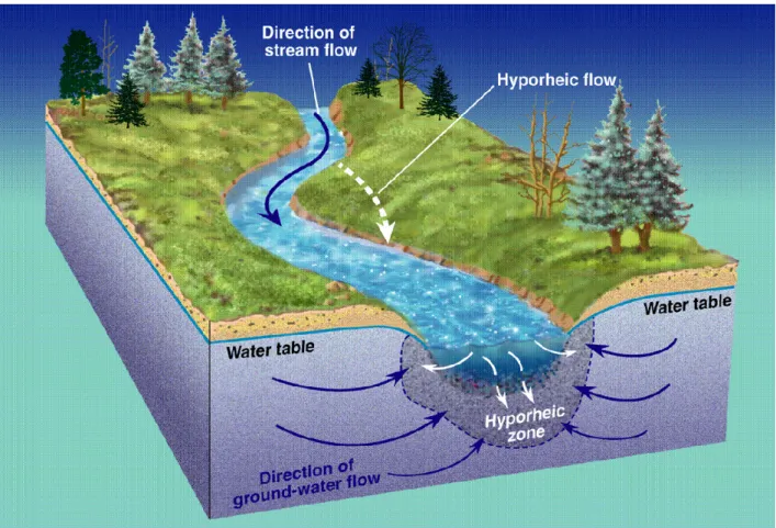
Groundwater-surface water interactions play a major role in ecosystem health (Bardini et al. 2002; Wondzell 2011) and functioning (Boulton et al. 1998; Malard et al. 2002; Thorp et al. 2006), as they control, amongst others, the water temperature (Bencala 2005; Hannah et al. 2009; Norman and Cardenas 2014), the nutrient availability (Fuller and Harvey 2000; Gooseff et al. 2002; Butturini et al. 2003), and the water quality (Boulton et al. 1998; Findlay 1995; Fuller and Harvey 2000) in the hyporheic zone (Fig. 1.1). Upwelling groundwater has a relatively constant temperature close to the mean annual air temperature. Hence, zones with groundwater upwelling are favourable for aquatic species which depend on stable water temperatures for living and breeding. Downwelling surface water, on the other hand, is richer
in dissolved oxygen and nutrients, such as plant debris, dissolved organic matter (DOM), dissolved organic carbon (DOC), or nitrate and sulphate, on which the aquatic species and thus the trophic chain in the hyporheic zone are highly dependent (Younger 2008). Additionally, the water quality in contaminated or polluted surface or groundwater bodies might be significantly improved by dilution with uncontaminated/unpolluted ground- or surface water, respectively. Therefore, (aquatic) ecosystem health and functioning is highly dependent on the mixing of groundwater and surface water, i.e. groundwater-surface water interactions, in the hyporheic zone. Anthropogenic disturbance to groundwater-surface water interactions may therefore have a severe impact on the local aquatic ecosystem, e.g. causing variations in the abundance and composition of type-specific communities or the total disappearance of disturbance-sensitive species (EU WFD 2000). Both of these effects may lead to severe deterioration of aquatic ecosystem functioning and their services to humankind, such as the purification of water or the provision of food (Mill. Ecosyst. Assess 2005). Hence, a thorough understanding of the causes for the degradation of groundwater-surface water interactions is of major importance. Findings in this area will support the identification of possible remediation methods aiding in enhancing groundwater-surface water interactions in degraded water courses.
A number of chemical and physical parameters may be examined for investigations of groundwater-surface water interactions, such as Radon-222 concentrations (Cartwright et al. 2014; Cook 2013; Hoehn et al. 1992) or water temperatures (Anderson 2005; Schneider 1962). The latter, in particular, is easily measured and relatively inexpensive. Investigations of groundwater-surface water interactions based on water temperatures thereby take advantage of the temperature difference between ground- and surface water (Anderson 2005). This effect is most pronounced in summer and winter, when the differences between groundwater and surface water temperatures are greatest. Investigations of groundwater-surface water interactions in spring and autumn are less conclusive, as the temperature difference between ground- and surface water may be too small. The shallow groundwater temperature fluctuates around the mean annual air temperature (Schneider 1962), while the surface water temperature varies depending on the weather and climatic conditions. Investigations of the water temperature thus allow conclusions to be drawn on the extent and behaviour of groundwater-surface water interactions in gaining conditions. In winter, for example, areas with higher water temperatures close to the groundwater temperature would indicate groundwater infiltration into the colder stream. A convenient method for such temperature measurements is Distributed Temperature Sensing.
1.1.3 Distributed Temperature Sensing (DTS)
DTS is a fibre-optical method for temperature measurements along a glass fibre based on the Raman effect (Farahani and Gogolla 1999; Soto et al. 2007a, b). The optoelectronic DTS instrument consists, amongst others, of a laser source and a detector unit. The laser source emits light pulses of subnanometer to nanometer length, depending on the instrument settings (see below) (Tyler et al. 2009). The length of the laser pulse depends on the refractive index of the silica glass of the glass fibre and the velocity of light therein:
(1.1)
with v being the light’s velocity in the glass fibre in [m/s], c being the velocity of light in a vacuum in [m/s], and n being the refractive index of the silica glass in the glass fibre in [/] (Eberlein et al. 2010). According to equation (1.1), with c = 299’792’458 m/s and n = 1.47 a spatial resolution of 1 m requires a laser pulse length of 5 ns.
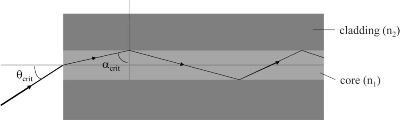
The laser pulse is injected into the glass fibre. The multimode glass fibre used in Raman-based DTS consists of a core of 50 m thickness made of GeO2-doped silica glass (SiO2), and
a cladding of 125 m thick un-doped SiO2 (Fig. 1.2). Apart from mechanical protection
against breaking and intrusion of OH--ions, which would dampen the signal due to absorption, this difference in optical densities, and therefore refraction indices, is necessary for the guidance of the laser light beam within the glass fibre (Eberlein et al. 2010). The laser light beam is refracted at the glass/glass interface between the optically denser core and the less optically dense cladding. If the angle of the laser light beam is above the critical angle crit,
refraction changes to total reflection and the laser light beam is contained within the core of the glass fibre (Fig. 1.3).
Figure 1.2. Structure of a multimode glass fibre. The light-grey core of GeO2-doped SiO2 has
diameter of 50 m, the grey cladding of un-doped SiO2 125 m. The thickness of the
Figure 1.3. Light propagation with total reflection in the glass fibre (Eberlein et al. 2010,
edited).
The critical angle crit is defined as
(1.2)
with n1 and n2 being the refractive indices of the core and the cladding, respectively, and
where n1 > n2. In the case of the fibre-optic cable n1 is the refractive index of the optically
denser core glass and n2 the refractive index of the less optically dense cladding (Eberlein et
al. 2010).
The laser light beam must be contained within the core of the glass fibre, as otherwise light would be lost to the cladding of the glass fibre, prohibiting light propagation within the glass fibre. In order to facilitate this total reflection of light in the core of the glass fibre, however, the angle of incidence of the laser light beam must be smaller than a critical angle, crit, also
termed the acceptance angle (Fig. 1.3).
The sine of crit is known as the numerical aperture, NA, which is defined as
(1.3)
Laser light beams inserted with an angle smaller than crit will be totally reflected with an
angle larger than crit, thus propagating within the core of the glass fibre (Eberlein et al.
2010).
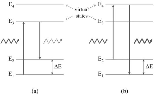
During propagation of the laser light beam in the glass fibre, laser light photons interact with the glass molecules of the glass fibre, being scattered either elastically (Rayleigh scattering) or inelastically (Raman scattering). In elastic Rayleigh scattering the scattered photons have
Figure 1.4. Schematic diagram of (a) Stokes and (b) Anti-Stokes scattering (Farahani and
Gogolla 1999, edited).
the same energy, i.e. frequency and wavelength, as the incident photons. In inelastic Raman scattering, the scattered photons’ energy is either higher or, usually, lower than that of the incident photons. This loss or gain of energy is due to excitation scattering: the photon interacting with a glass molecule either excites the latter, thereby losing the energy required for the excitation; or, the photon interacts with an already excited glass molecule, thereby gaining the energy that was released by the glass molecule falling back to its ground state. Those photons losing energy generate the Stokes signal, while photons gaining energy produce the Anti-stokes signal (Fig. 1.4).
Due to thermodynamic equilibrium, more glass molecules will be in a lower transitional state, causing the Stokes signal, than those in an excited state, causing the Anti-Stokes signal. Hence, the Stokes signal will usually be stronger than the Anti-Stokes signal (Fig. 1.5). This however, depends on the temperature of the glass fibre. The higher the temperature of the glass fibre, the more glass molecules will be in an excited state (Farahani and Gogolla 1999). This effect is used by Raman-based DTS instruments: by measuring the ratio of the Stokes to the Anti-Stokes signals, the temperature of the glass fibre, and therefore its surroundings, e.g. water in a stream, can be determined, using the following relationship:
Figure 1.5. Spectrum of backscattered light, return signal wavelength versus return signal
intensity (Hurtig et al. 1994, edited).
with IAS and IS being the signal intensity of the Anti-Stokes and Stokes signal, respectively, in
[ / ], h the Planck constant in [J s], R the frequency separation between the
Anti-Stokes/Stokes- and the Rayleigh-scattered light in [1/s], k the Boltzmann constant in [J/K], and T the absolute temperature of the glass fibre in [K] (Soto et al. 2007a).
Using Optical Time Domain Reflectometry (OTDR), the position of each temperature signal can then be determined. In OTDR, similar to RADAR, time-of-flight between the injection of a laser light pulse and its detection after arriving back at the DTS instrument is used to determine from which section of the glass fibre the temperature signal originated (Farahani and Gogolla 1999). Thus, the glass fibre is transformed into a linear temperature sensor, enabling temperature measurements along the whole length of the glass fibre.
The drawback of Raman-scattering, though, is that it only makes up a minute proportion of the total backscattered light, and high peak power of the laser and long measurement times are required to increase signal strength and reduce the signal-to-noise ratio. This issue can be overcome by the complementary-code correlated Golay coded OTDR technique (Nazarathy et al. 1989). This technique allows the use of low-power semiconductor lasers which have a long life-time and low power consumption. Furthermore, at a given spatial resolution, either a
higher temperature resolution or a higher temporal resolution, i.e. a shorter sampling interval, is possible (Soto et al. 2007b).
Thereby, spatial resolution defines the length of the glass fibre required to see 80 – 90 % of a temperature change, e.g. a 1 m spatial resolution requires 1 m to detect the temperature change between an ice bath and ambient temperatures. The temporal resolution is the time the DTS instrument collects the return Raman signals. The lower the spatial resolution and the temporal resolution, the lower the signal-to-noise ratio and the more accurate the temperature determined by the DTS instrument. However, information might be lost with a low spatial and temporal resolutions and the trade-off between the two settings has to be carefully considered during DTS measurements (Tyler et al. 2009). Currently available Raman-based DTS instruments offer spatial resolutions of up to 12.5 cm and temporal resolutions of 1 s. The DTS instruments employed in this research project had a minimum sampling resolution of 1 m and a minimum temporal resolution of 30 s.
The temperature data derived with DTS instruments has been used by various authors to estimate rates of groundwater upwelling (Briggs et al. 2012; Selker et al. 2006 b; Westhoff et al. 2011). These estimations were based on the methodology first described by Kobayashi (1985) and are suitable for gaining first-order streams. The upwelling of groundwater and the downwelling of surface water in higher order streams may be characterised with models described by Hatch et al. (2006), Hyun et al. (2011) and Vogt et al. (2010).
The DTS’ ability for high spatial, temporal and temperature resolution renders it a convenient method for high-resolution investigations of groundwater-surface water interactions in streams and brooks (Selker et al. 2006b; Lowry et al. 2007). Hence, this Ph.D. thesis employs DTS technology to investigating groundwater-surface water interactions, focussing on whether morphological changes to a river bed have an effect on groundwater-surface water interactions. This is done within the framework of the Record project and its follow-up project, Record Catchment.
1.2 Objectives and structure of this thesis
The overall goal of this Ph.D. thesis is the development of a DTS-method that will enable investigations of groundwater-surface water interactions in gaining and losing conditions, thereby answering the question of whether river restorations are an appropriate means of
enhancing groundwater-surface water interactions in degraded rivers and streams. This is achieved by a combination of laboratory investigations, field work and technical experiments. The special focus of this thesis is the effect of river restoration on groundwater-surface water interactions. In order to understand the correlation between river restoration and groundwater-surface water interactions, it was necessary to get a general idea about the river restoration techniques employed in Switzerland. Hence, the first objective of this Ph.D. thesis is a thorough review of the river restoration history of Switzerland, including the restoration techniques, success evaluations and possible spatial and temporal trends in river restorations. The results of this investigation are presented in Chapter 2.
In order to investigate the effects of river restoration on groundwater-surface water interactions, a suitable investigation method had to be selected. Distributed Temperature Sensing (DTS), measuring the temperature along a glass fibre of several hundred meters length, enables the simultaneous investigation of large sections of streams. The temperature difference between groundwater and surface water, as occurring in summer and winter, thereby allows investigations of groundwater-surface water interactions.
Well-established DTS methods have to date only been applied in investigating groundwater-surface water interactions under gaining conditions and in small streams and brooks (Selker et al 2006b; Lowry et al. 2007). However, groundwater-surface water interactions are likely to be equally important in larger streams and rivers and under losing conditions. Hence, the second objective of this work is the development of a DTS method that will enable measurements in all kinds of surface waters and hydrological conditions, including losing rivers and streams. However, this method required further developments of the so called active DTS method, first described by Perzlmaier et al. (2004), in which the metal components of the fibre-optic cable are heated. The active DTS method requires the presence of a direct operator, rendering active DTS measurements very time consuming, and limiting the areas in which active DTS could be applied. Hence, the third objective of this work is the development of an autonomous DTS system (ADTS system), which combines assets such as remote control, automatic heating of the fibre-optic cable and automatic data transfer. Chapter 3 specifies the components and construction of such an ADTS system, and discusses applications and limitations.
By aid of this newly constructed system, a new DTS methodology was developed, the PAB approach. The PAB approach combines passive (P) and active (A) DTS methods with a
fibre-optic cable buried (B) in the streambed. This approach enables temperature measurements, and thus investigations of the groundwater-surface water interactions, in gaining and losing conditions in water courses of all sizes. The sole limitation is the grain size of the sediment in the streambed, as the installation of the fibre-optic cable is very challenging in coarse sediments. Chapter 4 describes the PAB approach in more detail and presents data obtained with the PAB approach in a restored urban stream.
Based on the outcomes from the first three objectives, the fourth objective of this Ph.D. thesis is the investigation of the effects of river restoration on groundwater-surface water interactions. This objective is met by comparing field investigations in an urban stream before and after its restoration to two natural and near-natural reference streams. Chapter 5 presents the results and conclusions from these investigations.
Chapter 6 summarises the findings of this Ph.D. thesis and provides an outlook with recommendations for future research on groundwater-surface water interactions with DTS and river restoration practice.
Chapter 2
Thirty years of river restoration in Switzerland: implemented measures and lessons learned Published in Environmental Earth Sciences
Kurth, A-M., and Schirmer, M., 2014. Thirty years of river restoration in Switzerland: implemented measures and lessons learned. Environ. Earth Sci., 72(6), 2065 - 2079. doi 10.1007/s12665-014-3115-y.
Abstract
In the age of climate change and ecosystem degradation, governments realise more and more that it is crucial to protect ecosystem health, to preserve water resources, and to maintain flood protection. Therefore, several countries, among those Switzerland, have implemented laws to make the restoration of riverine ecosystems a legal obligation. In Switzerland, restoration projects were implemented as early as 1979, prior to these laws coming into force. For this article, 848 Swiss restoration projects, implemented between 1979 and 2012, were investigated, spanning a total of 307 river kilometres. No correlation was found between the geographical distribution of total restored lengths in a way that larger cantons performed more restorations. Neither was there a correlation between the total restored length and the cantons population density or financial status. Restoration activities increased steadily after 1992, with most restorations being reported for the years 2004, 2005 and 2009. The average restoration rate was 9.8 km per year, ranging between 0.5 km in 1979 and 23.9 km in 2004. Restoration measures were very diverse, ranging from measures that directly affected the wildlife, e.g. by providing habitats, to measures which indirectly enhanced conditions for the ecosystem, such as water quality ameliorations. Data regarding success evaluation was only available for 232 of the 848 projects, making it difficult to state whether the implemented restoration projects reached the intended objectives. Over the next 80 years, a further 4’000 km of Swiss rivers will be restored, requiring a restoration rate of 50 km per year, which, according to the data, is an achievable goal.
Keywords
2.1 Introduction
Over the last 150 years, human activities, such as urbanisation, agriculture and hydropower generation, have led to a gradual degradation of riverine ecosystems (Mill. Ecosyst. Assess. 2005). In recent decades, it has become apparent that further degradation must be inhibited, as the damages to ecology, economy and society surmount the benefits gained from exploiting riverine ecosystems (Zeh Weissmann et al. 2009). Nowadays, river restoration is the globally accepted means to protect ecosystem health, to preserve water resources, and to maintain flood protection (Andrea et al. 2012; Palmer et al. 2005; Wortley et al. 2013). Hence, river restoration projects are being financed by governments and made a legal obligation in several countries (EU WFD 2000; Swiss Water Protection Act 814.20). As available funds for river restoration increased, the number of implemented restoration projects and literature published on this topic grew as well (Wortley et al. 2013). However, most scientific publications focus on the success evaluation of restoration projects rather than the restoration measures themselves (Palmer 2005; Suding 2011). This gap is closed by showing, with the example of Switzerland, how river restoration was performed and how restoration practice changed over time. Despite its small size, Switzerland offers a large spectrum of restoration experiences due to its topographical diversity. Over the course of the next 80 years, 40 million Swiss Francs or 44 million US Dollars are being allocated per year to restore 4’000 km of degraded rivers and their ecosystems (BAFU 2011). This article presents the geographical distribution of restoration projects in Switzerland and investigates spatial and temporal trends. Furthermore, information on implemented restoration measures, a comparison of Swiss and international restoration data, and project success is presented. The article concludes with recommendations for the international restoration practice and science.
2.2 Data acquisition and definition of terms
The term restoration, the expression most commonly utilized in literature (e.g. Amoros 2001; Bernhardt and Palmer 2011; Haase et al. 2013), is used to describe a variety of measures to enhance, improve or rehabilitate the structure and function of riparian and fluvial ecosystems (Roni et al. 2005; Roni and Beechie 2013). Thereby, each restoration project may involve several restoration measures, which either directly or indirectly rehabilitate the ecosystem. Thereby, direct measures specifically improve conditions for the ecosystem, e.g. by providing habitats, while indirect measures have a different objective, such as flood protection, which
improve conditions for the ecosystem due to e.g. the reconnection of floodplains. Hence, measures, such as bioengineering or flood protection were included whenever they were implemented together with direct restoration measures.
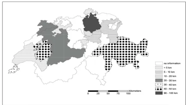
In Switzerland, the cantonal authorities are responsible for the management of water bodies, and thus the planning of restoration projects. Hence, data sets were obtained from the cantonal offices or their web pages. In total, data from 848 restoration projects from 13 of the 26 cantons, recorded between 1979 and 2012 (Fig. 2.1) were investigated. Data sets contained information about the name of the river, the total restored length per river, the start and end time of the implementation of the restoration measures, the type and objective of the restoration measures, if and how success was evaluated and the results of this evaluation. Nonetheless, data sets were not exhaustive, as some cantonal offices only recorded projects of a specific size or after the year 2000; other projects did not contain information about the length or the date of the restoration, and some cantons only had data records until the year 2010. Hence, numbers represented are not absolute, but rather reflect the available data at this time.
Figure 2.1. Geographical distribution of total restored length per canton between 1979 and
2012. Data from 13 of the 26 Swiss cantons are included (Berne, Fribourg, Geneva, Grisons, Jura, Nidwalden, Schaffhausen, Schwyz, Solothurn, St. Gall, Vaud, Zug and Zurich).
Additionally, data on the financial status and the level of urbanisation of the cantons was acquired in order to analyse spatio-temporal trends in river restoration (BFS 2009, 2012). Hereby, the financial status was represented by the gross domestic product of the year 2011 (GDP in Swiss Francs); the level of urbanisation by the population density of the year 2012 (inhabitants/ km2; BFS 2009 – 2013). The following two hypotheses were tested: (1) cantons with a higher GDP might have had more funds to finance river restoration projects, and (2) urbanised cantons might have more rivers in a degraded state than rural cantons and therefore a higher need for river restoration.
2.3 Spatial trends in Swiss river restoration
In order to analyse spatial trends in river restoration, data on the total restored length per canton was combined with the geographical map of Switzerland (Fig. 2.1). Hereby, the investigated cantons span an area of 25’335 km2 (61 % of the total area of Switzerland) and contain 37’699 km of rivers (62 % of the total Swiss river network).
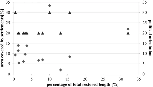
Figure 2.2. Relationship between the total restored length and the canton’s financial status
(gross domestic product in Swiss francs). The symbols represent the sizes of the cantons involved: a circle symbolises cantons with a total area below 1000 km2, a triangle cantons with 1000 – 2000 km2, a diamond stands for areas of 2000 – 3000 km2, and a square represents a cantonal area of more than 3000 km2.
Figure 2.3. Relationship between the level of urbanisation, as determined by the population
density of the cantons, and the total restored lengths. The symbols represent the sizes of the cantons involved: a circle symbolises cantons with a total area below 1000 km2, a triangle cantons with 1000 – 2000 km2, a diamond stands for areas of 2000 – 3000 km2, and a square represents a cantonal area of more than 3000 km2.
Of these, about 307 km were restored, ranging between total restored lengths of 1.5 km and 98 km per canton. However, due to gaps in data recording, these numbers might be significantly higher. As can be seen in Figure 2.1, there is no clear spatial trend, such as a higher total restored length for e.g. larger cantons. Hence, the relationship between the total restored length and the financial status of the cantons (Fig. 2.2) and their level of urbanisation (Fig. 2.3) was investigated. However, as can be seen in the charts, there is no such trend. Further investigations in land use and the political situation, i.e. election results, in the cantons showed no clear trend either (BFS 2009 – 2013, see Section 2.10).
2.4 Temporal trends in Swiss river restoration
Apart from the spatial trends in river restoration, the temporal trends were investigated, so as to determine whether the number or lengths of restoration projects increased over time. Figure 2.4 provides information about the time and length of implemented restoration projects for the
Figure 2.4. Primary axis: overview over the total restored length in Swiss water courses
between 1979 and 2012 in [km/year]. The number of cantons involved is shown above each column. Secondary axis: increase of total restored length between 1979 and 2012 in [km]. Please note the different scales of the axes.
cantons, the increase in total restored length for all of the 13 cantons, and the number of cantons performing restoration projects per year.
As can be seen in Figure 2.4, the total restored length and the number of cantons implementing restoration projects increased steadily after 1992. The decrease in the total restored length in the year 2012 is due to several data sets ending in 2010. On a Swiss-wide basis, most restoration projects were being performed in the years 2004, 2005 and 2009. On a cantonal basis, however, most restoration projects were implemented after the year 1997, with maximum restoration activities varying for each canton: while some cantons, e.g. Grisons and Zurich, continuously performed and recorded river restoration projects since the 1990s, other cantons, such as St Gall and Solothurn only started recording them in recent years. According to Figure 2.4, the total restored length for 13 of the 26 Swiss cantons accumulates to 270 km, as only projects where date and length of restoration were known were included. The total cumulative restored length, i.e. the cumulative length including those projects in which the date of restoration was unknown, is close to 307 km, though, and would be even higher if data
sets were conclusive. In 2011 it was decided to restore 4’000 km of the total 14’000 km of degraded streams (BAFU 2011) over the course of the next 80 years. This would require 50 km of river restoration per year in all of Switzerland. According to our data, restoration rates varied between 0.5 km in 1979 and 23.9 km in 2004, averaging to 9.8 km per year. Extrapolated to all of Switzerland, a restoration rate of 50 km per year therefore seems achievable, although challenging.
2.5 Implemented measures
The 848 investigated projects included a total of 1’661 restoration measures implemented between 1979 and 2012. Related restoration measures were separated into eleven categories (Table 2.1). Hereby, each category comprised a multitude of restoration measures. Those either directly or indirectly rehabilitated the ecosystem, e.g. by providing habitats or by stabilising a rivers’ embankment by planting endemic trees. Some restoration measures were purely mechanical, such as the widening of the river bed, while others enabled the river to rehabilitate itself, e.g. by removing stabilising side walls. Some restoration measures were implemented more frequently than others (Fig. 2.5).
Figure 2.5. Categories of restoration measures implemented in Switzerland between 1979 and
Table 2.1. Restoration measures implemented in Switzerland between 1979 and 2012. A
more detailed description of some of the restoration measures may be found in publications by Woolsey et al. (2005) and Zeh (2007).
category objectives measures
bioengineering stabilisation of riparian structures (e.g.
fascines); re-vegetation; enclosing of wildlife areas; diversification of the local flora; suppression of neophyte growth; creation of habitats; provision of shade
sowing/planting of endemic and site-specific plants (e.g. pioneer plants, reeds, sedges, shrubs, fruit and riparian trees (e.g. willow)); systematic clearing of trees; pruning of trees; pollarding of willows, poplars, etc.; sawing trees off above the root collar to stimulate stool sprouting; construction of fascines; installation of seeding mats on embankments
channel bed remodelling
bedload management: reduce or encourage channel bed erosion
recreate water course specific flow dynamics; removal or rebuilding of sediment traps and bedload collectors; deposition of eroded material; creation of areas for sedimentation; installation of nets over the sediment; installation of wood/stone weirs and spur dykes; construction of boulder ramps to reduce the flow energy of the water
channel bed deepening: create a higher water column as habitat and thermal refuge for aquatic organisms
excavation of accumulated sediments; narrowing of the channel bed and increasing of channel slope to induce erosion
removal of artificial barriers:
re-establishment of longitudinal connectivity; recreate water course specific dynamics and structures; bedload management
removal of stone/concrete weirs and dams; re-establishment of fish migration (construction of block/ground/concrete ramps, vertical-slot passages, pool passes and bypass channels); installation of opening in weirs; installation of pools in front of barriers; adjusting the water level of incised channels removal of stabilising elements from the river
bed: recreate a water course specific dynamic and structure; create habitats for flora and fauna; enable groundwater-surface water interactions
removal of stone blocks and concrete tiles from the channel bed
structuring of the channel bed: recreate a water course specific dynamic and structure; create habitats for flora and fauna
placement of material (e.g. wooden pegs, deadwood, tree spurs, root stools, gravel, boulders); installation of spur dykes, wood/stone weirs; demolition of anthropogenic structures (e.g. walls, bridges, pumping stations); construction of coves, shore protuberances, gravel banks, stream islands, meanders, or fords; recreation of the original channel bed; reduction of the curvature of meanders
channel diversion redirection of water courses away from
roads; improvement of appearance; amelioration of recreational value
mechanical excavation of a new channel bed
deculverting establishment of lateral, longitudinal and
vertical connectivity; creation of habitats for flora and fauna
uncovering piped streams, combined with channel bed remodelling
floodplain rehabilitation
construction of new side channels: flood protection; creation of habitats for flora and fauna
construction of new channels, drainage trenches, canals and ditches
reconnection of alluvial forests: flood protection; creation of habitats for flora and fauna
(re-)connecting of unconnected alluvial forests to the main river; opening and lowering of side dams; redirection of rivers into their former channel beds; re-establishment of water course specific dynamics
rehabilitation of oxbow lakes and side channels: flood protection; creation of habitats for flora and fauna
reconnection of oxbow lakes to the main river; removal of accumulated sediments
flood protection protecting anthropogenic structures from
flood damage
removal or construction of concrete walls, dams or bank reinforcements; relocation of garden sheds, houses and foot paths too close to the water course; construction of retention and temporary storage reservoirs with or without permanent ponds; reconnection of flood plains;increasing the height of existing dams, walls, or weirs, foot paths, village squares, and arable land; construction of weirs to redirect storm water into wetlands and swamps; installation of overflow channels for storm water; construction of separate sewers for storm water and sewage
category objectives measures
habitat provision creation and re-establishment of habitats for
flora and fauna
fish: placement of dead wood, root stools, boulders, wooden barriers with hideouts and recesses, fascines and overhanging shores as shelters; varying of water depths; installation of recess zones for flood events; creation of spawning grounds and areas for juvenile fish, with still waters and lose gravel or sand crayfish: excavation of deep water zones and hideouts amphibians and reptiles: construction of pools, permanent and temporary ponds, water-filled ditches or biotopes
reptiles: installation of sun terraces, screes, stone walls and dead wood stacks
heliophytes: construction of sun terraces birds: installation of nesting sites and perches beavers: installation of hedge screens
general: planting of trees, bushes, reeds and hydrophytes; installation and re-establishment of ponds and wetlands; construction of small bays, and of shores with varied inclination; re-establishment of grasslands
reintroduction encourage and accelerate recolonisation of
aquatic fauna
reintroduction of fish and other aquatic organisms riparian zone
construction works
structuring of stream banks: addition or removal of structures and plants as flood protection measure; increase lateral connectivity; creation of habitats for flora and fauna
stabilisation of shores and embankments: placement of boulders, dead wood and root stools; installation of rock-filled log cribwalls, fascines, and rock or wooden groynes; repair or construction of dams and concrete or stone walls;
bioengineering methods (see above)
removal of stabilising elements: removal of concrete blocks, stone or concrete walls and dams; reduction of size of dams modelling of terrain: lowering or elevation of embankments or reducing/increasing slope; introduction of sand or gravel; refilling of sediments
local widening of channel bed: increase in flow capacity; flood protection; support development of natural channel structures and dynamics; reduce channel bed erosion; creation of habitats
removal of bank reinforcements, mechanical excavation of sediments
visitor management
encouraging or prohibiting public access: protecting nature; improving recreational value
repair, construction or relocation of foot paths or pedestrian bridges; planting of hedges or tree hedges; installation of fences, playgrounds and observation points, leisure and fishing areas, nature trails and benches
water quality amelioration
enhancement of surface water quality: reduction of harmful substances; improvement of overall health of ecosystem
prohibition of feeding water fowl; relocation of sewage ponds; treatment of agricultural wastewater; construction of washing bays for agricultural vehicles
Habitat provision, channel bed remodelling, and deculverting make up 65 % of all implemented measures, thus being significantly more popular than the remaining 8 categories. To a certain extend this is an artefact, as e.g. the category channel bed remodelling is less clearly defined than e.g. deculverting and hence allows for more sub-categories, leading to a higher number of restoration measures in this group. Some measures, namely from the categories bioengineering, visitor management and water quality amelioration, were exclusively implemented in western Switzerland, while others, such as channel bed remodelling, deculverting, habitat provision and riparian zone construction works, were implemented in nearly all of the investigated 13 cantons.
In order to determine whether specific combinations of restoration measures were particularly popular, the prevalence of all category combinations was analysed. This included the frequency of single categories as well, as most restoration projects implemented a large
variety of restoration measures, but from only one category. The most common single categories were habitat provision, deculverting and channel bed remodelling. This was followed by the combination of the two categories channel diversion and deculverting; the prevalent combination of three categories was channel bed remodelling, habitat provision and riparian zone construction works. The four categories channel bed remodelling, flood protection, habitat provision and riparian zone construction works occurred only few times, as did the five-categories-combination bioengineering, channel bed remodelling, habitat provision, riparian zone construction works and visitor management. Combinations of six and more categories rarely occurred, usually combining measures to sustainably recreate a natural terrain while implementing flood protection measures. One or two-category combinations of interventions with a higher degree of mechanical interference, such as deculverting and mechanical recreation of the channel bed, were favoured over more sustainable combinations of three or more categories in which these high-interference measures were combined with measures to recreate a more natural setting and then protect the latter from human intervention. Generally, cantons in western Switzerland favoured the more sustainable combinations of restoration measures, while cantons in central and eastern Switzerland favoured single measures with a higher degree of mechanical interference, such as deculverting.
2.6 Brief description of selected restoration projects in Switzerland
Three water courses were selected to provide an overview over the bandwidth of restoration projects implemented in Switzerland: the Perrentengraben, a small brook in western Switzerland; the Rombach, a stream in south-eastern Switzerland; and the River Thur in north-eastern Switzerland. They were selected from three different categories of stream orders to illustrate the range of restoration projects from small brooks to large rivers in rural areas of perialpine and alpine Switzerland. Restoration projects in urban areas were omitted, in spite of their high number of occurrence, as they mainly focussed on the re-establishment of longitudinal connectivity by removing migration obstacles and the deculverting of previously covered brooks, which were already illustrated by the examples of the Rombach and the Perrentengraben. Further case studies of Swiss restoration projects may be found in Woolsey et al. (2005).
2.6.1 Perrentengraben, Canton Fribourg
The Perrentengraben is a small brook with a discharge ranging between 1 m3/s and 10 m3/s, situated in a rural area in western Switzerland. In 2001, 0.8 km of the brook were restored to create a more natural environment and support its biodiversity 1. This river restoration was selected from the 848 projects, as it combined a large variety of restoration measures often found in Switzerland. After deculverting the brook, which improved longitudinal, lateral and vertical connectivity, the channel bed was restructured to enable a more natural flow dynamics and provide habitats and recesses for the local fauna. The banks were remodelled, and stabilised with stones and an indigenous flora. Apart from facilitating habitats for terrestrial animals, these measures also improved lateral connectivity and provided shade, an important factor in water temperature regulation. Furthermore, a retention basin was installed, providing further habitats and flood protection. A more challenging restoration measure was the amendment of the water quality, which was achieved by treating agricultural waste water prior to its discharge into the brook.
The restoration of the Perrentengraben combined various restoration measures from the categories bioengineering, channel bed remodelling, deculverting, flood protection, habitat provision, riparian zone construction works and water quality amelioration to a sustainable river restoration, which encouraged self-regulation of the brook. This river restoration was one of the few projects which acknowledged the importance of “outside” factors, such as water quality, to the successful restoration of an ecosystem.
2.6.2 Rombach, Canton Grisons
The Rombach is an alpine stream in south-eastern Switzerland. Its discharge ranges between 1 m3/s and 23 m3/s, with an annual mean of 3 m3/s 2. Between 1995 and 2010 various sections of the river were restored in order to improve conditions for fish and maintain flood protection
3
. Two restorations at Pizzöl (Fig. 2.6 a, b) and Fuldera (Fig. 2.7 a, b) were selected: the installation of a block pass to ease the migration of fish and the restoration of a 2 kilometre long stretch of a channelized section. The block pass was built in a section of the river, where erosion had formed a migration obstacle impassable for juvenile fish. The migration obstacle
1 http://www.maisondelariviere.org/index.php/fr/activites/recherche/projets-termines/projet-renaturadata/330-la-maison-de-la-riviere-activites-recherche-renatura-data-boiron-de-morges-passe-a-poissons-sous-la-route-suisse 2 http://www.hydrodaten.admin.ch/de/2617.html 3 http://map.geo.gr.ch/oberflaechengewaesser/oberflaechengewaesser.phtml
was overcome by the insertion of large blocks in the stream bed, which were installed in various depth to encourage the formation of pools along the block pass. By spreading the difference in height over a distance of 50 m even juvenile fish may swim upstream. Positive side effects of the block pass were the reduction of flow energy in the water, which reduced erosion and acted as additional flood protection measure. Furthermore, appearance was improved. This restoration project combined measures from the categories channel bed remodelling, flood protection, habitat provision and visitor management. It was selected, as this kind of restoration is very common in Switzerland.
The second project at the Rombach restored a 2 km-section of the stream. After draining the swampy area and channelizing the stream in 1945, biodiversity decreased dramatically. Hence, it was decided to reverse the negative effect of the drainage and channelization. Therefore, land was repurchased to enable a widening of the stream. Stabilizing elements were removed from the stream banks and the surrounding floodplains lowered to encourage a self-regulated development of a natural stream dynamics and in-stream structures. The insertion of dead wood further encouraged the development of a natural stream dynamics and provided aquatic habitats. Eroded sediment was reintroduced and a downstream sediment trap removed to enable a more natural bedload management. In place of the previous sediment trap habitats for amphibians were created. The reconnection of side arms created further habitats for fish and amphibians and provided crucial spawning grounds for both. Bioengineering methods, such as the installation of willow fascines or the planting of indigenous plants, were selected to stabilize the stream banks, thereby providing terrestrial habitats and shade for water temperature control. As these measures greatly improved the ecological potential of the Rombach, it is planned to reintroduce the stone loach, a fish previously extinct in this stream.
(a) (b)
(a) (b)
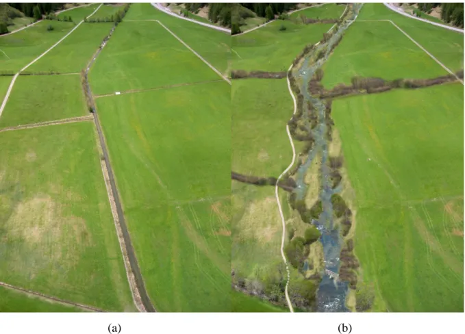
Figure 2.7. Rombach at Fuldera (a) before restoration and (b) an animation of the planned
outcome after restoration of the Rombach (© Pio Pitsch).
This restoration project combined measures from the categories bioengineering, channel bed remodelling, floodplain rehabilitation, flood protection, habitat provision, reintroduction, riparian zone construction works and visitor management to recreate a natural, self-regulated ecosystem. The Rombach restoration was selected as it is a good example for a very effective restoration in a rural, alpine region, in which the ecological conditions and appearance could be greatly improved.
2.6.3 River Thur, Cantons Zurich and Thurgau
The River Thur (Fig. 2.8 a, b) is a perialpine river in north-eastern Switzerland. It is the longest Swiss river without a retention basin, leading to a very dynamic discharge regime (Woolsey et al. 2007; Peter et al. 2012). Discharge ranges between 2.2 m3/s and 1130 m3/s, with a mean discharge of 47 m3/s (Pasquale et al. 2011). Due to frequent flooding by the then meandering river, long sections of the River Thur were straightened and channelized in the

![Figure 2.4. Primary axis: overview over the total restored length in Swiss water courses between 1979 and 2012 in [km/year]](https://thumb-eu.123doks.com/thumbv2/123doknet/14954191.668717/39.892.117.776.114.548/figure-primary-overview-total-restored-length-swiss-courses.webp)