HAL Id: halshs-00431305
https://halshs.archives-ouvertes.fr/halshs-00431305
Submitted on 12 Nov 2009
HAL is a multi-disciplinary open access
archive for the deposit and dissemination of sci-entific research documents, whether they are pub-lished or not. The documents may come from teaching and research institutions in France or abroad, or from public or private research centers.
L’archive ouverte pluridisciplinaire HAL, est destinée au dépôt et à la diffusion de documents scientifiques de niveau recherche, publiés ou non, émanant des établissements d’enseignement et de recherche français ou étrangers, des laboratoires publics ou privés.
Can flood risk management restore ecogeomorphologic
functioning of fluvial margins along the Rhône River
(France, SE)?
Simon Dufour, Mireille Provansal, Guillaume Raccasi
To cite this version:
Simon Dufour, Mireille Provansal, Guillaume Raccasi. Can flood risk management restore ecogeomor-phologic functioning of fluvial margins along the Rhône River (France, SE)?. IVth ECRR International Conference on RIVER RESTORATION 2008, Jun 2008, Italy. pp.349-356. �halshs-00431305�
4
thECRR Conference on River
Restoration
Italy, Venice S. Servolo Island 16-21 June 2008
CAN FLOOD RISK MANAGEMENT RESTORE ECOGEOMORPHOLOGIC
FUNC-TIONING OF FLUVIAL MARGINS ALONG THE LOWER RHÔNE RIVER
(FRANCE, SE)?
Dufour S.
1*, Provansal M.
1, Raccasi G.
1 1Aix Marseille Université – CEREGE CNRS * Corresponding author, e-mail: dufour@cerege.frABSTRACT:
Over the last centuries, the Rhône River has been deeply modified by numerous uses and activities like navigation, irrigation, fight flooding, hydroelectricity production… Embankment, dams and groyns
constructions, water diversion, and secondary channel artificial cut-off generated morphological changes such as channel degradation and narrowing, bank stabilization, and former channel terrestrialisation. These changes result in a fundamental modification of flowing conditions during floods and connections between channel and floodplain ecosystems.
Within the framework of compensatory measures, the CNR (Compagnie Nationale du Rhône, i.e. the Rhône River manager) wants to carry out a restoration project along the downstream reach of the Rhône River (southern France, 100 km length upstream from the mouth). The ambition is to combine both a decrease in local flood risk (by enlarging flood-carrying capacity) and an enhancement of geomorphological and ecological properties of the margins into the reach (sediment reworking, pioneer species regeneration…).
The Rhône River is a good case study for complex and deeply altered systems. Indeed, important issues have to be integrated: (i) flood risk for the major city along the reach (Arles), (ii) bank erosion control near cultivated areas, (iii) former channels loss of diversity due to terrestrialisation processes and floodplain forest deconnection because of the channel degradation, (iv) pollution risk if polluted sediments are reworked (contamination by metals, PCB and radionuclides), (v) navigation, and (vi) sediment deficit that impacts coastal evolution downstream the reach (Camargues delta).
We present a step-by-step strategy to reach an equilibrium between human activities and ecological purposes. All aspects are discussed: can historical state be considered as a reference-state? How can we choose sites to test the actions? How to design these actions? Which monitoring strategy has to be developed? Which kind of ecosystems can be expected under Mediterranean climate (composition, recovery rate, presence of exotic species…)?
Key words:
1. INTRODUCTION: A RECENT CHANGE IN FLOODING CONDTIONS
Over the last decades the Rhône River has undergone significant morphological adjustment: stabilization, narrowing and deepening for several reaches (for the lower Rhône River see: Arnaud Fassetta, 1998; Antonelli, 2002; Raccasi, 2008). As a result of the floodplain evolution and channel configuration, we now observe significant changes in flooding conditions. For example, during the 2003 flood event (maximum discharge 11500 m3.s-1) some reaches underwent an higher waterlevel in the channel (for example +0.3 m upstream of Arles city, cf. figure 1) than during the 1856 flood (maximum 12500 m3.s-1). These observations led the Compagnie Nationale du Rhône (CNR, structure in charge of the Rhône River management) to set in motion some rehabilitation projects along the upper and middle Rhône River (Bravard et al., 2008). Over the last decade, the CNR also initiated some rehabilitation actions in order to improve ecological functioning and diversity of Rhône’s floodplain by former channel opening and excavation (Henry et al., 2002; Amoros et al., 2005).
The aim of this paper is to present the framework developed since 2007 for fluvial margins rehabilitation along the lower Rhône River reach. Because of this reach specificities (multiplicity of issues and stakeholders: inundation, bank erosion, pollution, navigation, riparian ecosystems, sediment transfer to coastal area), a particular framework has been developed.
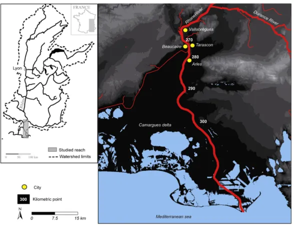
Figure 1: Location map.
2. REHABILITATION OF THE LOWER RHONE RIVER MARGINS: A GENERAL FRAMEWORK
The main goal of the rehabilitation project for the 70 km of lower Rhône River (from Vallabrègues to the sea) is to limit inundation during flood events, notably nearby the very sensitive areas such as Arles and Beaucaire-Tarascon (Figure 1). To tackle this question, we plan to increase channel capacity to evacuate floods by eroding fluvial margins that have been sedimented since the 19th century. Several strategies could be employed to initiate the eroding process: opening former channels, groyns removing, enhance bank erosion…
The project is made up of 2 steps. The first consist in testing the effect of rehabilitation upon a limited number of sites and the second in extending, if it is possible, actions to others sites along the
reach. The first step begun in 2007 and will be achieved in 2010. It can be divided in 7 successive steps (Table I). The first one is achieved; the second and third ones are still in progress.
Table I: framework for lower Rhône River rehabilitation project
Steps Detail, intermediary steps Goals
1. bibliographic analysis
Inventory of available data for the reach (hydrology, morphology, ecology)
To analyze the recent evolution of the reach To identify missing data and understudied sites within the reach
Acquisition of additional information To have homogeneous knowledge for the reach
2. selection of the sites
Identification of area filled by sediments during the 20th
century (notably former channels)
To identify all the sites that can be rehabilitated = potential sites (geomorphological criterion) From the potential sites list, identification of ownership
constraint (exclusion of private sites)
To select sites on which the CNR can act quickly (legal criterion)
3. initial state
Implementation of the initial state:
- historical evolution (from aerial photos, old plans) - current topography
- sedimentation (thickness, grain size, associated pollutant) - hydraulic conditions (waterlevel during floods…) - vegetation (species, habitats)
To describe selected sites for rehabilitation before works
4. design of actions
- Description different potential methods (scenario, type of works and expected decrease in water level),
- Identification of risks associated to each scenario - Financial estimation
To choose rehabilitation methods according to selected sites and locales constraint 5. implementation
of actions Implementation of works according to selected methods To rehabilitate fluvial margins
6. monitoring
Monitoring implementation: - topography
- sediment deposits - hydraulic conditions
- vegetation (recovery cartography, communities characteristics)
To monitor the effectiveness of the selected methods
7. adjustment Adaptation of the actions (depending of the results of the monitoring process) To improve method effectiveness
3. DIAGNOSTIC: MORPHOLOGICAL CHANGES AND THEIR CAUSES (1876-2006).
To achieve the rehabilitation project a precise evaluation of both historical changes in floodplain topography and flood carrying capacities is needed.
3.1. Morphological changes (1876-2006)
Historical data analysis (old maps and surveys) clearly demonstrate that the lower Rhône River un-derwent several changes in channel geometry and bank position over the last 150 years (channel in-cision and narrowing, former channel sedimentation, bank accretion). For example, at the kilometric point (kp) 275.5, the channel has undergone a bed degradation of 2 m as well as a 500 m active chan-nel narrowing between 2006 and 1876 (Figure 2). For the same discharge (5800 m3.s-1; 2 years return period), increase in water level at this point is close to 0.5 m.
The comparison of two DEMs (1876 and 2006) gives an accurate quantification and localization of the sedimentation. Between Beaucaire and Arles (9 km), 9x10⁶ m3 of sediment have been accumulated over the last 130 years. These modifications occur mainly in the channel and nearby, whereas the ex-ternal part of the floodplain was quite stable over the period.
3.2. Causes
The current channel geometry results from the evolution of external controls and local constraints. Both flood event (Pichard, 1995) frequency and sediment supply from tributaries decreased since the 19th century. because of natural and artificial afforestation and dams’ construction (Vallauri, 1997; Landon, 1999; Bravard, 2002; Kondolf et al., 2002; Marston et al., 2003; Piegay et al., 2004). Con-sequently sediment transport decreased from 900 000 m3y-1 to 200 000 m3y-1 during the 20th century (BCEOM, 2003), whereas during the same period, mean discharge was constant (Pardé, 1925; François, 1937; Anselmo et al., 2005).
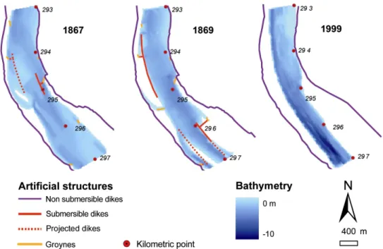
The regulation works (dikes, groyns…) built downstream of Beaucaire between 1870 and 1938, to improve navigation, also greatly participated to the observed adjustments. For example, some groyns and submersible dikes from kp 293 to kp 297 have been built since 1867 (figure 3) to limit lateral
mo-bility in concavities and to close the side channels. They resulted in a very fast channel narrowing of 80 m from 1867 to 1869.
Figure 2: Channel cross sections at the kilometric point (kp) 275.5 in 1876 and 2006. Main changes are illustrated here: channel degradation and narrowing, sedimentation in former channels.
Figure 3: An example of regulation impact on channel geometry (incision and narrowing)
4. SITES SELECTION AND MULTIPLE ISSUES MANAGEMENT
The rehabilitation project of the lower Rhône River concerns a 70 km length reach where several issues are overlaid (Table II). On one hand, the instream introduction of sediments stored in the floodplain could cause negative consequences to others aspects such as private land erosion, navigation, and polluted sediments introduction. On the other hand, this action could benefit sediment supply to coastal area or ecological functioning of the floodplain. Moreover, all the length is not favourable to implement actions. Indeed, the vulnerability to inundation is concentrated only in the first kilometres of the reach and not in the Camargues delta. To increase erosion, channel gradient is also more favourable upstream from Arles. As a result, few sites appear to be potentially rehabilitated (2 to 4 sites along 70 km).
Table II: summary of issues to take into account in the rehabilitation project
Issue Positive consequences of the rehabilitation Potential negative consequences or constraints
Sediment transfer Sediment reworking can increase sediment
supply to coastal area (in deficit)
Current deficit is higher than potential available sediment During flood events a large part of the sediments move to the sea and do not participate to the coastal alimentation
Ecology Improve ecological functioning of the
floodplain and increase biodiversity by former channel rehabilitation
Expected habitats are not known because of a deeply and formerly impacted system with very few reference sites Increase in exotic species frequency (Amorpha fruticosa L.,
Ludwigia spp.)
Pollution Sediment reworking can re-introduce pollutants in the systems
(PCBs, mineral pollutants: metals and radionuclides)
Navigation Actions must be limited to preserve the navigability of the
reach: conserve a water level high enough and no change in channel position
Bank erosion Rehabilitation actions have to generate not any problem of bank
erosion of private area
5. CONCLUSION: IS THE REHABILITATION OF THE MARGINS A DURABLE SOLUTION FOR THE LOWER RHÔNE RIVER?
Along rivers that have recorded narrowing process over the last decades, sediment remobilisation could be used to decrease water level during flood events. From a theoretical point of view, this is particularly efficient for floodplains which present a high accretion rate. But, as for many rehabilitation projects, the technical limitation were not the biggest. Along the lower Rhône River, taking into account all the issues led to a drastic reduction of experimental sites number (and the area). So we expect a limited effect of actions upon flooding conditions (evaluation in progress). A negative feedback could be generated and make harder the extension of these actions to other sites or reaches.
To conciliate flooding management and eco-morphological several questions must be solved; the first is fundamental and complex: which kind of ecosystem we may expect? In our situation, human impact is ancient and strong and reference can’t be a “natural” one. We clearly assume the impossibility to go back to the situation of the 19 or early 20th century, and that the past is not a better reference. A new reference must be identified, but how?
ACKNOWLEDGEMENTS
This project was funded by: Region PACA, CNR and Symadrem. The authors thank especially Mrs Doutriaux, Collillieux, Barale and Moiroud from the CNR (Compagnie National du Rhône).
REFERENCES
Amoros C., Elger A., Dufour S., Grosprêtre L., Piégay H., Henry C., 2005. « Floodscouring and groundwater supply in side-channel rehabilitation of the Rhône River, France”. Archiv für Hydrobiologie, Supplementband 155, 147-167.
Anselmo, V., Georgakakos, K.P., Gottschalk, L., Holly, F.M., Kosut, P., Ogink, H. et Sigrist, B., 2005. Débit maximal de la crue du Rhône de décembre 2003 à Beaucaire. Avis du Comité Scientifique. In: CEMAGREF (Editor), Conférence de consensus. Débit du Rhône à Beaucaire pour la crue de décembre 2003, Lyon, pp. 13.
Antonelli C., 2002. Flux sédimentaires et morphogénèse récente dans le chenal du Rhône aval. PhD thesis, Aix Marseille, 272 p.
Arnaud Fassetta G., 1998. Dynamiques fluviales holocènes dans le delta du Rhône. PhD thesis, Aix Marseille, 329 p.
BCEOM, 2003. Etude globale pour une stratégie de réduction des risques dus aux crues du Rhône. Etude du transport solide, Volet 5 : Modélisation hydraulique de la zone deltaïque du fleuve Rhône en aval de BEAUCAIRE, EPTB, Valence.
Bravard et al., 2008 Widening by-passed reaches of the Rhone River following sediment deposition, France. 4th ECRR International Conference on River Restoration.
Bravard, J.P., 2002. The adjustments of fluvial systems to the decrease in water and sediment fluxes following mountain reafforestation. Houille Blanche-Revue Internationale De L Eau(3): 68-71.
François, L., 1937. Etude sur l’évolution actuelle des côtes de Camargue, Institut des Etudes Rhodaniennes. Revue de Géographie Régionale, 13 71-126.
Henry C.P., Amoros C., Roset N. 2002 – Restoration ecology of riverine wetlands: a 5-year post-operation survey on the Rhône River, France. Ecological Engineering, 18: 543-554.
Kondolf, G.M., Piegay, H. et Landon, N., 2002. Channel response to increased and decreased bedload supply from land use change: contrasts between two catchments. Geomorphology, 45(1-2): 35-51.
Landon, N., 1999. L'évolution Holocène du profil en long des affluents du Rhône moyen. Constat régional et analyse d'un hydrosystème complexe, la Drôme, Paris IV Sorbonne, Paris, 560+annexes pp.
Marston, R.A., Bravard, J.P. et Green, T., 2003. Impacts of reforestation and gravel mining on the Malnant River, Haute-Savoie, French Alps. Geomorphology, 55(1-4): 65-74.
Pardé, M., 1925. Le régime du Rhône, étude hydrologique. Thèse de doctorat Thesis, Université de Grenoble, Grenoble, 1323 pp.
Pichard, G., 1995. Les crues sur le bas Rhône de 1500 à nos jours. Pour une histoire hydro-climatique. Méditerranée, 3-4: 105-116.
Piegay, H., Walling, D.E., Landon, N., He, Q., Liebault, F. et Petiot, R., 2004. Contemporary changes in sediment yield in an alpine mountain basin due to afforestation (the upper Drome in France). CATENA, 55(2): 183-212.
Raccasi G., 2008. Mutations morphologiques récentes du Rhône aval, recherches en vue de la restauration hydraulique et de la gestion des crues. PhD thesis, Aix Marseille, 334 p.
Vallauri, D., 1997. Dynamique de la restauration forestière des substrats marneux avec Pinus nigra J.F. Arnold ssp. nigra dans le secteur Haut Provençal. Trajectoires dynamiques, avancement du processus de restauration et diagnostic sur l’intégrité fonctionnelle des écosystèmes recréés, Université Aix-Marseille III Saint-Jérôme, Marseille, 301 pp.