HAL Id: hal-03033226
https://hal.archives-ouvertes.fr/hal-03033226
Submitted on 1 Dec 2020HAL is a multi-disciplinary open access archive for the deposit and dissemination of sci-entific research documents, whether they are pub-lished or not. The documents may come from teaching and research institutions in France or abroad, or from public or private research centers.
L’archive ouverte pluridisciplinaire HAL, est destinée au dépôt et à la diffusion de documents scientifiques de niveau recherche, publiés ou non, émanant des établissements d’enseignement et de recherche français ou étrangers, des laboratoires publics ou privés.
to characterize the northern limit of the Mediterranean
biogeographical area
Julien Andrieu, Florent Lombard, Matthieu Vignal, Michel Godron, Frédéric
Alexandre
To cite this version:
Julien Andrieu, Florent Lombard, Matthieu Vignal, Michel Godron, Frédéric Alexandre. A phyto-climatic transect in the Alpes Maritimes used to characterize the northern limit of the Mediterranean biogeographical area. Biodiversity Journal, 2020, 11 (3), pp.679-688. �10.31396/Biodiv.Jour.2020.11.3.679-688�. �hal-03033226�
A phyto-climatic transect in the Alpes Maritimes used to
characterize the northern limit of the Mediterranean
biogeo-graphical area
1University Côte d’Azur, UMR ESPACE, 98 boulevard E. Herriot, 06204 Nice cedex 02, France; email: florent.
lombard@univ-cotedazur.fr
2CNRS, La Graineterie, 18410 Brinon sur Sauldre, France; email: migodron@wanadoo.fr
3University Paris13, EA Pleiades, 99 Avenue Jean Baptiste Clément, 93430 Villetaneuse, France; email:
alexandre@univ-paris13.fr
*Corresponding author, email: julien.andrieu@univ-cotedazur.fr
ABSTRACT This paper aims, with a botanical transect, to contribute to define the boundary between the Mediterranean biogeographical area and the flora of the Alpine domain. The transect, realized in 2018, is located in the Maritimes Alps, in the Roya Valley at the northernmost limit of the Mediterranean in contact with a mountain ecoregion. Our objective was to get as close as pos-sible to the integral flora (Tracheophytes), that counts a corpus of 529 species. A 40 km long transect divided in 150 sampling sites led to 7333 observations of presence, analyzed by Fac-torial Composant Analysis (FCA) and frequency analysis. Statistics revealed a significant dis-tinction of two floras with a clear spatial boundary not crossed by 76% of the species. The Transect revealed a clear biogeographic limit of biogeographical area, which seems to converge well with the limit of the Mediterranean Hotspot as defined by Myers (2000).
INTRODUCTION
Defining biogeographical areas is a major sci-entific issue (Myers, 2000, Olson et al., 2001; Cox, 2001; Mackey et al., 2008; Hattab et al., 2015), es-pecially for plants, which are less often taken into consideration when delineating these boundaries (Kier et al., 2005). However, the main challenges for biodiversity conservation caused by mass ex-tinctions (Godet & Devictor, 2018) and the impact of climate change (Molinos et al., 2018) are a major requirement for this, whether in terms of biogeo-graphical division of the planet (Good, 1947; Takhtajan, 1986) or because of the needs of
identi-fying particular biogeographical structures. For ex-ample, the work of Myers (1990) on defining bio-diversity hotspots remains a major reference, as more recent works on hotspots overall have merely characterized or subdivided them (Médail & Quézel, 1997; Olson et al., 2001).
The definition of biogeographic areas also in-volves a precise, spatial examination of their bound-aries (Ferro & Morrone, 2014; Morrone, 2018). An object can only be mapped accurately by validating its boundary. The boundary of a biogeographic area combines the boundaries of specific distribution areas. These rarely coincide with one another and area boundaries appear as forms of more or less
KEY WORDS Phyto-climatic transect; Biogeography; Mediterranean; Hotspot; Biogeographical areas.
Julien Andrieu*1, Florent Lombard1, Matthieu Vignal1, Michel Godron2 & Frédéric Alexandre3
Biodiversity Journal, 2020,11 (3): 679–688 https://doi.org/10.31396/Biodiv.Jour.2020.11.3.679-688
of the Mediterranean biogeographical area? What is its level of spatial accuracy?
The development and increasing accessibility of large natural history or environmental databases has fostered a large majority of research programmes on biogeographical areas to develop tools for spatial analysis (classification or clustering of species, sta-tistical characterisation of the specific patterns of pre-established regions, biodiversity hotspots or ecoregions), or the investigation of phenological variability by means of satellite imagery.
This paper relies on an original and ad-hoc field study carried out to help validate these spatial proaches to area boundaries. The naturalistic ap-proach in the field necessarily reduces the scale of analysis when time, financial and human resources are limited, but the discussion will aim to refocus the regional terrain in a global, or at least Mediter-ranean, perspective, albeit, which - from a method-ological standpoint - will deal with the boundaries of the areas as a whole.
Several significant regional transects have been conducted since the 1990s and 2000s to identify the Mediterranean area boundary (Alexandre, 1994; Génin, 1995; Alexandre et al., 1998a; Alexandre et al., 1998b; Godron & Andrieu, 2013). This work has made it possible to demonstrate that flora varies as a continuum without clear limits common to sev-eral species. This pattern was expected as long as it had been encountered for all other 4 transects around the northern limit of the Mediterranean area in France.
In addition to all this research, a transect was carried out in spring 2018 in the Roya valley, shed-ding light on the Mediterranean area boundary, which is unique because it is at one of the northern-most points of the area boundary among the Mediterranean-mountain contacts. It is one of the places where the climatic contrast is higher.
It thus contributes to define the boundary be-tween the Mediterranean and Alpine biogeograph-ical areas. So far, botanbiogeograph-ical investigations in the region have largely focused on overlapping floral species. For example, it is frequently pointed out that one can find Holm oaks (Quercus ilex) and Sil-ver firs (Abies alba), which are considered to be-long to very different habitats, regularly together. In addition to the continuum without clear limit, the expected pattern was a large overlap between Mediterranean and alpine Floras.
gradual transitions (Whittaker, 1967; Ferro & Mor-rone, 2014). Making a detailed examination of the limits of specific distributions at the edges of bio-geographical areas is also a particularly topical ob-jective to understand the impact of climate change on species distribution (Molinos et al., 2018).
One of the characteristics of the Mediterranean area is that a major part of its boundary coincides with mountain ranges. These mountain ranges can be floristic provinces (Alps, Atlas Mountains) and sometimes they separate two distinct bioclimatic areas as a result of a climatic barrier effect (Cevennes, Ligurian Alps). Thus, defining the limit of the Mediterranean area requires placing the boundary between the Mediterranean mountains (high-altitude Mediterranean flora) and those at its periphery (non-Mediterranean flora). This could also appear as a matter of scale because the Mediterranean area was considered a kingdom in the same way as the Circumboreal region (Takhta-jan, 1986), while the Alps a smaller subdivision only. However, a more recent work (Condé & Richard, 2002) places within Holarctic Kingdom both Mediterranean and Alps as regions of the same level. The Alps are defined as an area in clas-sifications subdividing provinces based on an eco-logical approach as the Ecoregions (Olson et al., 2001). Here, we will refer to the Alpine area as being a part of the Central European region.
The Mediterranean biogeographical area has been defined and redefined over the centuries (Quézel & Médail, 2003). The inclusion of the Mediterranean area in Myers’ list of hotspots and the production of a map disseminated as georefer-enced and open-access files have helped to set this limit for research work and for territorial biodiver-sity management tools. However, this limitation of the Mediterranean hotspot and the Mediterranean biogeographical area still raises a number of ques-tions:
- How are the species boundaries between the Mediterranean and the Alps spaced out in this area where one goes from the coastline to an altitude of 2,500 meters within a distance of just 40 kilome-ters?
- Does a significant limit appear? With what re-generation rate of the flora on both sides?
- Is there a transition by impoverishment or by overlap?
Phyto-climatic transect in the Alpes Maritimes
MATERIAL AND METHODS Data collection
Gao & Kupfer (2018) demonstrated that a biogeo-graphic regionalization must be based on spatially ex-plicit methods and not only on ecological ones. We chose the “systematic random” transect sampling method, in which the samples are consecutive linear segments of equal size. As in every sampling, this spatial sampling should make it possible to test any hypothesis of variation modality. For effective
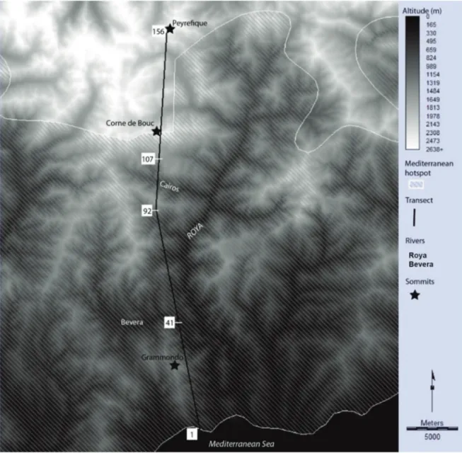
sam-pling, the transect must be oriented to be as heteroge-neous as possible (Alexandre et al., 1998a). It was therefore to be oriented along a north-south axis where the altitudinal, and therefore climatic, gradient is the highest since it runs from the seafront to the crest line separating France and Italy (Fig. 1).
Sampling must then provide for the evaluation of the spatial variation patterns, which requires, on the one hand, a regular and continuous grid and, on the other hand, an adapted scale allowing to finely describe the variation without anthropic or edaphic microvariations prevailing over biogeographic
con-681
siderations. Segments of 250 m by 10 m were there-fore arranged in sequence along the entire transect. However, we cancelled a few segments where an-thropogenic activities are too strong for proper bio-geographical analysis.
Our objective was to get as close as possible to the integral flora. For this purpose, we recorded the presence of all the species identified to constitute the largest possible corpus. However, our aim was not to identify and list species exhaustively and cer-tain taxa were excluded for some reasons like:
- Some non-flowering species could not be iden-tified with certainty at the time of the year when the sampling took place (e.g., Gallium).
- Some taxon was recorded as lacking effective morphological criteria for identification (e.g.,
Hi-eracium).
- All green flowering monocotyledons were ex-cluded from the study (Poaceae, Cyperaceae, Jun-caceae).
Some taxa are not included due to a lack of in-formation but the corpus of 529 species is rich enough for an original data collection. All statistics have been repeated with all species and without a set of species that might contain identification er-rors. Results have been very consistent, therefore, the dataset is considered as robust enough. The non-native species have been observed and included in the statistics. If native species only are usually used for biogeographic studies, we decided to describe flora as it has been observed not as it should be ac-cording to past models. The transect was carried out between April 1st and August 1st, 2018 and 150 segments of 250 meters were chained together. Only 6 samplings could not be carried out due to the overly artificial environments. Therefore, they range from 1 to 156 with missing numbers to re-spect the range-distance numbering. We identified 529 species and compiled 7333 observations.
Spatial analysis methods
Three indicators of floristic variation in space will be put into perspective: the coordinates of axis 1 of the Factorial Correspondence Analysis (FCA), the area/species curves and the optimal limit.
The FCA and its derivatives
The first step in the statistical analyses was a
FCA directly on the presence-absence data table. The eigenvalues of the first two axes are 12.4% and 6.6%. The factorial plane describes the main con-trasts in the scatter plot. The first main component here is that which characterizes the biogeographic contrast under study.
The species-area curve
The species-area curve reflects the increase in number of species as the exploration effort pro-gressed. It is calculated along the transect in both directions.
Structural analysis: the spatial aspect of frequency analysis
Frequency analysis highlights the significant features of frequency distributions within a set of ecological observations. It is based on the exact probability that each frequency distribution of a characteristic phenomenon will appear, such as the coexistence of two species in all the locations ob-served, wherever one species appears in each class of ecological descriptor such as altitude, etc. Struc-tural analysis is a part of frequency analysis and fo-cuses on the spatial distributions of ecological observations. The spatial distributions are here ex-amined by the optimal limit. It is a measure of the homogeneity of the two transect sections located on either side of each of the “transitions” between two consecutive segments (between the first and second segments, between the second and third segments, etc.) and thus highlights the most remarkable tran-sitions, which provide the most information.
To discuss the validity of the transect results be-yond the simple case of a field study, we conducted a valley-wide survey with the same objective but based on the Mediterranean National Botanical Conservatory’s SILENE Database using a carto-graphic approach. SILENE (Système d'Information et de Localisation des Espèces Natives et En-vahissantes, or information and location system for native and invasive species) is a database of floristic observations made by the Mediterranean National Botanical Conservatory. Each geolocated observa-tion of a species can be downloaded, and all the ob-servations of a territorial entity as well, as was the case here. The surveyed territory included the French communities of the Roya Valley and those
those usually carried out on this type of data by a strong discontinuity between two groups of sam-pling sites, which shows that there are two distinct types of sampling sites when seen from a floristic point of view. The absence of individuals in the sampling sites at coordinates close to the origin was equally significant. A few variables (species) are visible in the centre of the 1/2 factorial plane.
Furthermore, a careful examination revealed that the two groups of sampling sites are very clearly structured spatially, since all the those to the south (from segment 1, a sampling site on the coast to number 106 by the adret slope of the Cairos val-ley, at 1500 meters altitude) are in the Mediter-ranean group on the left with negative values or close to the origin. All the sampling sites to the north (from 108 to 156, at Pointe du Sabion at 2500 meters altitude) are in the Alpine group on the right. Only sampling sites 106 and 107 appear to be a very short transition between the two biogeographic fea-tures. There is an obvious relationship between al-titude and first axis coordinates (Fig. 3)
The second axis is a classification of the sam-pling sites of these two groups separating the open environments in positive values and the forest en-bordering it west of the French-Italian border. We
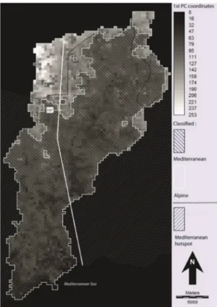
made 100,000 observations of 2,841 taxa (species or subspecies). First, we drew a grid of 400 m x 400 m across the whole Roya Valley and a similar area across a strip of land over French communities equivalent to the upstream Italian section to cover the same gradient to the sea. We constructed a pres-ence-absence table based on the grid in a similar way to that of the transect. We performed a Facto-rial Correspondence Analysis on this data table. An unsupervised K-means classification into 2 classes was also produced. It locates the area boundary be-tween sampling sites 107 and 108 of the transect (Fig. 5). An SQL selection allows to count the species of three distributions: present only in the Mediterranean area; present only in the Alpine area; and lastly in both areas, as defined by the K-mean classification.
RESULTS The FCA
The 1/2 factorial plane (Fig. 2) differs from
Figure 2. 1/2 factorial plane derived presence-absence data table.
vironments in negative values. The positive sam-pling sites on axis 2 and those negative on axis 1 correspond to matorrals and are associated with the most strictly heliophilic Mediterranean species (Calendula arvensis; Coronilla valentina;
Med-icago polymorpha; Crepis vesicaria; Cuscuta ep-ithymum) or thermophile exotic species (Opuntia ficus-indica; Oxalis pes-caprae). The positive
sam-pling sites on axis 2 and those positive on axis 1 correspond to the Alpine pastures and summits and are associated with the most strictly heliophilic Alpine species (Saxifraga oppositifolia,
Ranuncu-lus pyrenaeus, Draba dubia, Adenostyles leuco-phylla, Minuartia sedoides, Draba aizoides, Petrocallis pyrenaica, Leontopodium nivale).
To facilitate a graphical interpretation of these 3 indicators, all have been expressed in percentages with 0% assigned to the minimum value and 100% to the maximum value of the indicator.
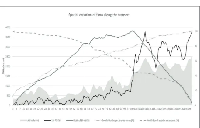
Figure 3 relates these patterns to the altitude along the transect. The coordinates of axis 1, south of the transect at fairly low elevations, vary little in the form of 100-meter scale microvariations with a very slight slope of the whole between values rang-ing from 0 to 15% for the first 55 samplrang-ing sites and
between 10 and 25% up to sampling site No. 105. The curve then slopes extremely steeply with sam-pling sites 106 and 107 having intermediate values and 108 very high values. Beyond this threshold, the coordinates vary greatly according to altitude, with values between 50 and 70 % for mountain val-leys and between 80 and 100 % for peaks and ridges. The first factorial axis has a correlation of 0.98 with altitude. However, it is worth noting that in the first 2/3 (Mediterranean) of the transect, axis 1 varies less than the altitude, while in the last third (Alpine), axis 1 varies more strongly than the alti-tude.
Species-area curves
The two species-area curves are almost linear, but there are some slight differences.
The species-area curve from north to south shows a rapidly increasing richness of Alpine species over about ten sampling sites. The trend slows down to reach a threshold around 15 sampling sites and then increases again with a few species be-fore the threshold of the Alpine range consolidates with 40% of the flora found in the 30 northernmost Figure 3. Spatial variation of flora along the transect.
The optimal limit
The optimal limit confirms and quantifies the clear separation of the two floras with a curve that increases with a few steps until it reaches its maxi-mum value for the same transition zone between samples 106 and 107, which constitutes the optimal limit between two biogeographic entities.
Specific richness
The variation in species richness along the tran-sect adds to this interpretation. The number of species is usually greater than 50 in the first 100 samples and then quite lower in the higher altitudes. The variation in the number of species drops rather significantly on either side of the transition between samples 107 and 108. The greatest range of low species richness samples is to be found between samples 107 and 122 (always less than 40). This confirms that the transect reflects a shift from an area with a Mediterranean endemism (and exotic species) in contact with Alpine flora and that this contact occurs by impoverishment and not by an overlap of the two flora.
site. A major threshold is reached again, on this same slope of the Cairos valley, from sampling sites 106 and 107, where a 20% increase of the flora occurs in ten samplings. Then, a series of small thresholds show a flora enrichment until reaching a 90% flora level in 110 sampling sites where the curve gently slopes down to the coast. So there is a clear delin-eation of the Mediterranean flora at sampling site No. 107 on the slope of the Cairos valley as high-lighted by the first 3 indicators. From south to north, the species-area curve is much less contrasted. The slope is quite steep to the south of the transect with the 50% flora level reached in 35 samplings. The slope bends somewhat gradually to reach 95% of the flora level at sampling site No. 125 before gaining the last 5% within 3 small thresholds. While the Mediterranean flora is well delimited here with very typical flora delimited by the convergence of the 3 indicators, the species-area curve from south to north shows that the Alpine flora is not a clearly de-fined and homogeneous flora, except by contrast to the Mediterranean flora. This may be explained by the small number of high-mountain samples and the variability of the flora between mountain forests and Alpine pastures.
Figure 4. Altitude variation of axis 1.
The classification of the surveys by altitude rank (Fig. 4) shows that all the altitudes were sampled, even if the sampling effort, in fact, is somewhat weak around 1300 meters. At around 1650 meters, the curve takes a very steep slope to reach the higher values (Alpine flora). The break in floristic continuity, as seen from a spatial point of view (Fig. 3) between samples 106 and 107, converges with that in floristic continuity as considered from an ecological standpoint around altitudes between 1500 and 1600 meters.
The detailed examination of samples 89 and 90 is interesting. The altitudes are quite high (1510-1530 m), higher than the next 16 sampling sites and this altitude is only found on sites 105 and 106. Further-more, samplings 89 and 90 are a summit and north-facing slope while sampling sites 105 and 106 are on the adret side. A strictly ecological interpretation would lead to expect more Alpine flora for sample sites 89 and 90 than for 105 and 106, but the type of flora is actually much more Mediterranean. This could lead us to infer that the spatial boundary (100 samples in the south and 50 in the north) is stronger than the ecological boundary on either side of an al-titude or its corresponding thermal conditions.
A detailed examination of the species distribu-tions in relation to this boundary shows that if the transect is split in two, between samplings 107 and 108, 115 species are found only im the north and 287 species only south of the boundary. Therefore, 76% of the species are related to the boundary, which is a particularly high rate (Tables 1, 2).
The validation by a close analysis, on all the SILENE points (see supplementary material) vali-dates that the flora changes rapidly at the level of the 107 survey, generalises the limit between the two biogeographical sets at the valley scale and quantifies, on a cartographic basis, with more species, that 52.6% of the species are only restricted to the Mediterranean part, accompanied by 10.1% of species only restricted to the Alpine part.
DISCUSSION
The main result of this statistical analysis of the transect is the clear-cut boundary that separates the Mediterranean flora that appears homogenous and the Alpine flora that appears less homogenous with an altitude-dependent variation quite related to a differentiation between forest flora and grassland flora.
However, this result is only of interest in bio-geography if it is valid on smaller scales. The tran-sect was deliberately located at the contact zone between the Mediterranean area and the Alpine chain where the gradient is strongest. The transect goes from sea level to 2600 meters in 40 km. Its configuration comprise a topographic leap, since the slope of the Cairos separates the valley bottom (at 870 m) and the summit of the Corne de Bouc (at 2430 m) in only 5 km, i.e., 20 segments of the tran-sect. One may quite reasonably assume that these topographic features induced an increased contrast
Table 2. Species distribution according to area limit on the SILENE dot grid.
North only South only Common Total
Species richness 115 287 127 529
Percent of total 21.7 54.3 24 100.0
North only South only Common Total
Species richness 287 1494 1060 2841
Percent of total 10.1 52.6 37.3 100.0
Mediterranean species not crossing the line are very close, 54.3 % on the transect and 52.6 % on the grid. This limit, highlighted by the transect, should therefore be generalised, especially that of Mediter-ranean species, more than that of Alpine species.
The representativeness of the results is com-mensurate to the scale of the valley but it remains very large scale in relation to the Mediterranean biogeographical area. However, this grid analysis also made it possible to map the difference be-tween this boundary and that of the Mediterranean hotspot. Although differences appear at this scale, as the Hotspot boundary is higher in the north-west and lower in the south-north-west, these boundaries are often only a few hundred meters and, at most, a few kilometers away from one another. This field campaign and the complementary analysis under a GIS validates very clearly the outline of the Mediterranean Hotspot, that can be downloaded as GIS dataset (www.cepf.net). However, we can-not broaden this spatial validation to sectors where the hotspot boundary lies in a plain. It can be as-sumed that the configuration described here is characteristic of the boundary of the Mediter-ranean area when it is in contact with the mountain flora of another biogeographical area.
CONCLUSIONS
The species boundaries between the Mediter-ranean and the Alps, an area where the climatic gra-dient is short, seem to be concentrated in a medium mountain sector at altitudes of around 1500 meters. A vast majority of Mediterranean affinity species end before this threshold and the Mediterranean re-gion, thus delimited, is characterized by a fairly clear homogeneity. This significant limit, which ap-pears on the transect on the adret side of Cairos river, could be generalized by a line separating the low and high areas of the study area. The renewal of the flora on either side of this line is 76% accord-ing to the transect. It amounts to 62% accordaccord-ing to geomatics. This is a transition by depletion since less than a quarter of the species extends across this line and their limits are at varying distances from it. Samplings north of the line are characterized by relatively low richness. The breadth of the transition zone seems particularly reduced (a few hundred meters).
and that a transect a few hundred meters further east or west, where this difference in elevation would have been spread out over a greater distance, would have been less contrastive.
However, a second analysis discussed in the supplementary material section made it possible to carry out a presence-absence FCA over the whole Roya valley and not only along a sampling line. This provides an overview of the transition to high mountains in this valley. The unsupervised classi-fication of the FCA coordinates locates the bound-ary in the same area as the transect and thus broadens it to the whole valley. We can see two rather compact entities, although a few islands and enclaves appear. The SQL selection for quantifying species that do not cross the line reveals lower rates than those of the transect (62.7% versus 76.4%). This proves the transect to be drawn in the most contrasted area. This was the original intention sup-porting this sampling choice. However, although the total volume is lower, it is still clear that the limit coincides spatially and that the rates of
Phyto-climatic transect in the Alpes Maritimes 687
Figure 5. Classification of biogeographical areas and boundary of the Mediterranean hotspot.
The boundary of the hotspot and the boundary of the Mediterranean biogeographical area seem to converge well if one examines these lines on the macro-regional or global scale where the hotspot boundary was drawn. There are a few hundred me-ters of difference between the two lines, some-times locating the hotspot, somesome-times the area higher up.
REFERENCES
Alexandre F., 1994. Entre midis méditerranéen et atlan-tique, une transition phytoclimatique du Languedoc à l’Aquitaine. Thèse de doctorat Géographie Paris 7 Dir. Lecompte M., 428 pp.
Alexandre F., Génin A. & Lecompte M., 1998a. Seuils biologiques et limites climatiques en Méditerranée occidentale. Géocarrefour: Revue de Géographie de Lyon, 73: 33‒43.
Alexandre F., Génin A., Godron M. & Lecompte M., 1998 B. Distribution des plantes et organisation de la végétation. L’Espace géographique, 27: 228‒238. Sophie Condé & Dominique Richard (coordinators)
2002. Europe’s biodiversity - biogeographical re-gions and seas. EEA, Copenhagen 2002 https://www.eea.europa.eu/publications/report_2002 _0524_154909
Cox B., 2001. The biogeographic regions reconsidered. Journal of Biogeography, 28: 511‒523. https://doi. org/10.1046/j.1365-2699.2001.00566.x
Ferro I. & Morrone J. J., 2014. Biogeographical Transi-tion Zones. Biological Journal of the Linnean Soci-ety, 113: 1‒12. https://doi.org/0.1111/bij.12333 Gao P. & Kupfer J.A., 2018. Capitalizing on a wealth of
spatial information: Improving biogeographic region-alization through the use of spatial clustering, Ap-plied Geography, 99: 98‒108. https://doi.org/10. 1016/j.apgeog.2018.08.002.
Génin A., 1995. Les contacts entre domaines phytocli-matiques. L'exemple de la bordure cévenole. Thèse de doctorat Géographie, Paris 7 Dir. Lecompte M. Godet L. & Devictor V., 2018, What conservation does.
Trends in Ecology & Evolution, 33: 720‒730, https:// doi.org/10.1016/j.tree.2018.07.004.
Godron M. & Andrieu J., 2013. Mise en évidence statis-tique d’un continuum à facettes le long d’un transect floristique dans les Baronnies. Actes du colloque Continu et discontinu dans l’espace géographique. Tours Novembre 2002. Maison des Sciences de l’Homme. Presse Universitaires François Rabelais, 145‒170
Good R., 1947. The Geography of Flowering Plants.
Longmans, Green and Co, New York, 516 pp. Hattab T., Albouy C., Lasram F.B., Le Loc’h F.,
Guilhau-mon F. & Leprieur F., 2015. A biogeographical re-gionalization of coastal Mediterranean fishes. Journal of Biogeography, 42: 1336‒1348 https://doi.org/10. 1111/jbi.12505
Kier G., Mutke, J., Dinerstein E., Ricketts T.H., Küper W., Kreft H. & Barthlott W., 2005. Global patterns of plant diversity and floristic knowledge. Journal of Biogeography, 32: 1107‒1116. https://doi.org/10. 1111/j.1365-2699.2005.01272. x
Mackey B.G., Berry S.L. & Brown T., 2008. Reconciling approaches to biogeographical regionalization: A sys-tematic and generic framework examined with a case study of the Australian continent. Journal of Biogeog-raphy, 35: 213‒229.
Médail F. & Quezel P., 1997. Hot-Spots Analysis for Conservation of Plant Biodiversity in the Mediter-ranean Basin. Annals of the Missouri Botanical Gar-den, 84: 112‒127. https://doi.org/10.2307/2399957 Médail F. & Quezel P., 2003 Ecolgie et biogéographie
des forêts du bassin méditerranéen. Editions scien-tifiques Elsevier, Collection environnement, 574 pp. Molinos J.G., Poloczanska E.S., Olden J.D., Lawler J.J. & Burrows M.T., 2018. Biogeographical Shifts and Climate Change. Dellasala D.A. & Goldstein (Eds.), Encyclopedia of the Anthropocene, M.I. Elsevier, 217‒228. https://doi.org/10.1016/B978-0-12- 809665 -9.09814-1.
Morrone J.J., 2018. The spectre of biogeographical re-gionalization. Journal of Biogeography, 45: 282‒ 288. https://doi.org/0.1111/jbi.13135
Myers N., 1990. The biodiversity challenge: expanded hot spots analysis. The Environmentalist, 10: 243‒ 256. https://doi.org/10.1007/BF02239720
Myers N., Mittermeir R.A., Mittermeir C.G., Da Fonseca G.A.B. & Kent J., 2000. Biodiversity hotspots for conservation priorities. Nature, 403: 853‒858. https:// doi.org/10.1038/35002501
Olson D.M., Dinerstein E., Wikramanayake E.D., Burgess N.D., Powell G.V.N., Underwood E.C., D'Amico J.A., Itoua I., Strand H.E., Morrison J.C., Loucks C.J., Allnutt T.F., Ricketts T.H., Kura Y., Lamoreux J.F., Wettengel W.W., Hedao P. & Kassem K.R., 2001. Terrestrial ecoregions of the world: a new map of life on Earth. Bioscience, 51: 933‒938. https: //doi.org/10.1641/0006-3568(2001)051[0933: TEO TWA]2.0.CO;2
Takhtajan A., 1986. Floristic Regions of the World (trans-lated by T.J. Crovello & A. Cronquist). University of California Press, Berkeley, 401 pp.
Whittaker R.H., 1967. Gradient analysis of vegetation. Biological Reviews, 42: 207‒264. https://doi.org/0. 1111/j. 1469-185X.1967.tb01419.x