HAL Id: halshs-00458587
https://halshs.archives-ouvertes.fr/halshs-00458587
Submitted on 21 Feb 2010HAL is a multi-disciplinary open access archive for the deposit and dissemination of sci-entific research documents, whether they are pub-lished or not. The documents may come from teaching and research institutions in France or abroad, or from public or private research centers.
L’archive ouverte pluridisciplinaire HAL, est destinée au dépôt et à la diffusion de documents scientifiques de niveau recherche, publiés ou non, émanant des établissements d’enseignement et de recherche français ou étrangers, des laboratoires publics ou privés.
Going West? Spatial polarization of the North Korean
port system
César Ducruet, Stanislas Roussin, Jin-Cheol Jo
To cite this version:
César Ducruet, Stanislas Roussin, Jin-Cheol Jo. Going West? Spatial polarization of the North Korean port system. Journal of Transport Geography, Elsevier, 2009, 17 (5), pp.357-368. �halshs-00458587�
Going West? Spatial Polarization of the North Korean Port
System
Published in: Journal of Transport Geography 17(5), 357-368
César DUCRUET
Erasmus University Rotterdam School of Economics Faculty of Applied Economics
Department for Regional, Port and Transport Economics Burg Oudlaan 50 PO Box 1738 3000DR Rotterdam The Netherlands Tel. +31 (0)10-408-1678 Fax +31(0) 10-408-9141 Email: ducruet@few.eur.nl Stanislas ROUSSIN SERIC COREE
1302 Byucksan Digital Valley V, 60-73 Gasan-dong, Geumcheon-gu, Seoul
153-801 Republic of Korea Tel: +82 (0)2-2082-5613 Fax: +82 (0)2-2082-5616 Email: roussin@seric-coree.com
Jin-Cheol JO
Korea Research Institute for Human Settlements (KRIHS) 1591-6 Gwanyang-dong
Dongan-gu, Anyang-si, Gyeonggi-do 431-712 Republic of Korea
Tel. +82 (0)31-380-0164 Fax +82(0) 31-380-0482 Email: jincjo@krihs.re.kr
Abstract
This paper analyzes North Korean ports in light of existing models of port system evolution.
It reviews the economic and political factors shaping port concentration in developed,
developing, and socialist countries. A database on vessel movements allows for the analysis
of individual North Korean port traffic by total capacity circulated, cargo type, fleet
nationality, immediate origin and destination, and berthing time. While ideological factors
and military control hamper port modernization and trade openness, traffic concentration at
the Pyongyang-Nampo gateway highlights the spatial polarization in the capital region at the
expense of Eastern ports for which inland transport limitations and industrial decline have
become major issues. The North Korean case only partly fits general models because traffic
concentration occurs due to geopolitical isolation and internal limitations rather than
economic and trade growth.
Keywords: DPRK, Maritime traffic, North Korea, Port system, Regional development
Acknowledgements
The authors would like to thank Prof. Brian Slack (Concordia University, Montreal) and Dr.
Wouter Jacobs (Erasmus University, Rotterdam) for their useful comments as well as Editor
Prof. Richard Knowles and the three anonymous reviewers whose remarks helped improving
1. Introduction
The fate of ports has long been associated with unpredictable circumstances (Jackson,
1983). Throughout the world, the improvement of transport systems and the integration of
ports within multimodal transport chains foster port concentration and competition (Slack,
1985; Hoare, 1986). The literature depicts how ports adapt to change through different sets of
local and national policies, strengthening their performance and their insertion in intermodal
systems and value chains (Notteboom and Rodrigue, 2005; Jacobs and Hall, 2007). While
such trends seem to be valid for ports operating in relatively opened economies, it is not yet
verified whether they apply to the constrained and autarchic economy that has become the
Democratic People’s Republic of Korea (DPRK; hereafter referred to as North Korea). Comparing North Korea with other constrained economies would improve our understanding
of the relation between port systems and regional change. Most studies of port systems, which
focus mainly on developed nations due to more accessible information, have neglected social
and political considerations explaining traffic change. Ports in relatively closed or
less-developed economies often receive little attention, because they are not performing well
enough or are not sufficiently inserted in the networks of global players. This is regrettable
because not only periods of growth but also periods of decline shall be analyzed in order to
better understand the transport geography of spatial change.
In the 1960s and 1970s, North Korea was regarded as the most dynamic East Asian
economy after Japan. However, it started to falter, declining from the 1980s onwards due to
geopolitical change and economic mismanagement (Oh and Hassig, 1999). The two major
factors are the disappearance of the socialist block in 1991, with which North Korea handled
most of its trade, and the death of president Kim Il-Sung in 1994, which led to a political
important economic reforms, introducing some elements of the market economy1. The new
attitude of the current regime is closely associated with South Korea’s efforts for economic
cooperation, as seen in the two inter-Korean presidential summits of 2000 and 2007, and the
relatively successful development of the Gaeseong and Geumgang special zones near the
border (Ducruet et al., 2008). In addition, an industrial corridor is emerging between
Pyongyang and Nampo, the capital’s gateway, through joint ventures between local and foreign companies (Roussin and Ducruet, 2007). However, there remains a debate among
specialists on whether such reforms are paving the way towards a Chinese model or if they
remain an accidental survival strategy (Yoon, 2006).
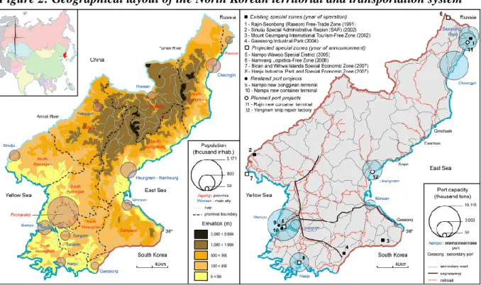
North Korean ports are strategically located in Northeast Asia (Figure 1), notably
regarding their potential for connecting the Europe-Asia land bridge in a context of regional
economic growth and integration (Choi et al., 2003; Rozman, 2004). However, North Korea
remains a barrier rather than a bridge and most land-based shipments from Japan, China, and
Korea preferably use either the Trans Siberian or Trans China railroads. The eight
international trading ports are regularly distributed along the East and West coasts, in
accordance with the configuration of the urban system (Figure 2). The study of North Korean
ports is worthwhile for realizing two main objectives:
a) Confronting existing models of port system evolution to the case of a politically
isolated and economically constrained country;
b) Complementing the general knowledge on North Korean geography and economy by
looking at how geopolitical change and regional dynamics are highlighted through the
evolving traffic distribution.
While available information about North Korea remains limited to partial political and
economic data (Jo and Adler, 2002a), we propose using a world database on vessel
movements provided by Lloyd’s Marine Intelligence Unit (LMIU), an independent
organization which insures approximately 80% of the world fleet. Aggregating data on vessel
capacities makes it possible to obtain a snapshot of the situation of North Korean ports along
three main periods: growth and stagnation before the collapse of the USSR (1985-1991),
geopolitical isolation (1992-1998), economic reforms, inter-Korean cooperation, and foreign
investments (1999-2006). Such information is by far the most accurate source for studying
constrained economies, because all other governmental organizations provide only rough
estimates of North Korea’s maritime trade (Ducruet and Jo, 2008). North Korean ports are controlled by the army that does not provide any information on traffic and infrastructure.
Because a comprehensive study of North Korean ports and transport system is lacking, this
research also synthesizes numerous and dispersed information from economic intelligence,
governmental reports, and press releases published on this country.
The remainder of the paper is organized as follows. Section 2 provides an overview of
the relevant literature on port systems in transport geography. Section 3 represents the core of
the paper. It first introduces a brief historical background of North Korean ports, then explains
the methodology, and goes through the analysis of port traffic distribution along the three
main periods. Concluding remarks in section 4 discuss the lessons drawn from the case of the
North Korean port system.
2. Port system evolution in transport geography
2.1 General trends
The analysis of port systems is an important part of transport and regional
transportation system that redesigns inter-port relationships on various geographical scales
(Slack, 1993).
The port system is a rather vague geographical concept. On the one hand, it
corresponds to the port region or land area within which port activities substantially impact
the economic structure (e.g. employment), but it is often confounded with the hinterland that
reflects the market area in which inbound and outbound port-related transport flows take
place. It is also understood as a group of ports situated in geographical proximity, such as the
maritime façade, which is based on a single and continuous coastline, and the port range that
is defined by interdependency among ports sharing multiple vessel calls. Finally, the port
network represents the service coverage of a given carrier, regardless of the geographical
proximity.
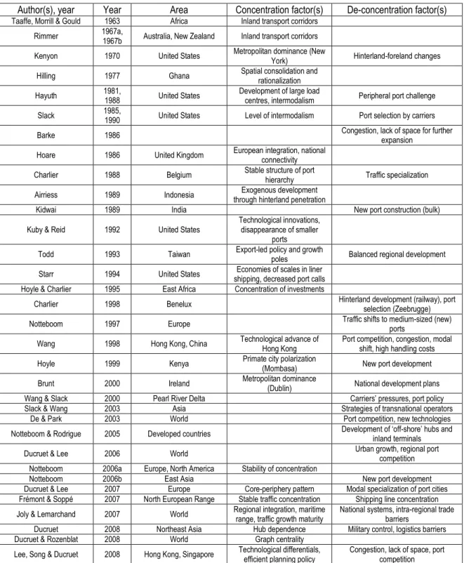
Table 1 provides an overview of the main port concentration studies. There is a
gradual shift from concentration to deconcentration studies. Empirical evidence highlights the
limits of excessive concentration in several parts of the world, defined by traffic capture at
one main load centre. Concentration, for instance, stems from the path-dependency of large
agglomerations (e.g. New York) and the resilience of large load centers (e.g. Hong Kong)
implementing efficient urban and port planning policies avoiding congestion. Deconcentration
occurs due to new port development, carrier selection, global operation strategies,
governmental policies, congestion, and lack of space at main load centers.
Port traffic is related to economic activities and spatially spreads through a transport
system. Therefore, changes in traffic distribution are closely related to changes in the spatial
organization of the economy. The degree of concentration within a port system can be a good
indicator of regional dynamics. For little known countries such as North Korea, lack of
information on internal changes may be overcome by examining the distribution of port traffic
implications for such a phenomenon, a closer look at the specificities of port systems in
developing and socialist countries is needed.
[Insert Table 1 about here]
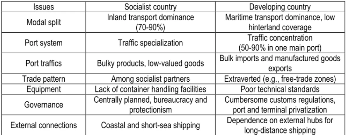
2.2 Port system evolution in developing and socialist countries
Defining thoroughly the notions of developing country and socialist country would
reach beyond the scope of this paper. Nevertheless, the two emerged in the specific context of
the Cold War era, defined as the Second World (socialist) and the Third World (developing),
by comparison with the First World (developed or capitalist). Different categories have been
proposed, notably after the Cold War, such as socialist developing countries, applying to the
world’s only five remaining communist countries i.e. China, Vietnam, Laos, Cuba, and North Korea. The main differences between socialist and developing port systems involve land
transport, traffic distribution, and traffic type (Table 2). In the former Soviet Union, the
spatial division of port functions serving the continental hinterland centralized in Moscow
formed a star-shaped railway network aimed at controlling access to the different seas
(Thorez, 1998a). Although socialist leaders often expressed their disregard for sea transport,
maritime trade in socialist economies grew from 2% in 1939 to 9% in 1991 (Vigarié, 1995),
reflecting the extension of their influence to countries only accessible through sea transport
(e.g. Cuba, Vietnam, and Africa). After the collapse of the USSR, ports located in newly
independent countries (NICs) adapted to new hinterland patterns by diversifying traffic and
modernizing infrastructure (Thorez, 1998b). Maritime transport in socialist countries was long
perceived as costly, of little use, and limited to coastal shipping. The new geopolitical context
forced Russia to develop long-distance trades with remote trade partners such as Cuba
despite inland transport limitations with the development of special economic zones and open
cities along the coast (Lo, 1989).
Since the 1960s, literature on port systems has emphasized the impact of
containerization on Asian colonial and post-colonial port cities (Basu, 1985; Murphey, 1989;
Kidwai, 1989). Technological changes in shipping and globalization processes caused port
concentration and selection, questioning the notion that the amount of cargo handled by the
port was strictly proportional to the economic weight of the surrounding region (Todd, 1993).
The model proposed by Taaffe et al. (1963) shows the degradation and disappearance of
minor ports due to the growth of gateway ports at the head of transport corridors, where
agglomeration economies are intensified. The argument of Smolensky and Ratajczak (1965)
about the shift of larger cities from centre to periphery is questioned by Stern and Hayuth
(1984), who observed that remotely located ports have limited local impact due to their
dependence on inland core regions. Although port development relates to the existing urban
structure of a given country, attempts to develop peripheral regions through port activities in
developing countries have been rather limited (Fujita and Mori, 1996). Spatial concentration
of population, economic activity, and port traffic also appeared in socialist countries such as
Cuba (Alfonso, 2001).
Besides the aforementioned issues, port development in developing and socialist
countries is dictated by wider mechanisms of state planning, resource allocation, and
settlement structure. The relative absence of property rights, lack of international openness
and human capital, limited infrastructure and manufactured inputs, small market size, and
complex governance often result in a lack of incentives and innovation (Edwards, 1993;
Tybout, 2000). This is exactly the case in North Korea, where reliance on heavy industries
and military control prevented the emergence of a competitive advantage in the world
port capacity, outdated infrastructure, and inadequate cargo handling facilities (Ahn, 2001;
Yoon and Babson, 2002; Ahn, 2003). As seen in Table 3, North Korean ports remain
relatively small, poorly equipped, and specialized in the handling of bulky products, while
limitations of nautical accessibility indicates wide gaps with global shipping standard
requirements. As a result, most cargo is loaded and unloaded by hand using a large quantity of
workforce at the docks (Ducruet and Roussin, 2007a). This situation can be accentuated by
bureaucratic obstacles and institutionalized corruption that is defined by favored military and
power-holding elites having better access to information, foreign manufactured goods, travel
opportunities, nepotism, and cronyism (Bermudez, 2006). In Indonesia, cumbersome customs
regulations once hampered the spread of containerization (Airriess, 1989) and still nowadays
more than 80% of Indonesian trade is transshipped through Singapore due to low port
capacity locally (Ghani, 2006). Similarly, the national renovation policy of Vietnamese ports
faces low technical standards and port capacity (Vinh, 2004). In other cases such as Baltic
ports, port reforms and increased private participation in port management allows a steady
modernization (Brodin, 2003). Whether such trends are reflected in a socialist developing
country like North Korea is verified in the next sections.
[Insert Table 3 about here]
3. Port concentration in North Korea
3.1 Background and research perspectives
Centrally located for economic, trade and cultural exchange amongst neighboring
powers, the Korean peninsula has always been under pressure for geopolitical control,
resulting in the reluctance of Korean elites opening the country (Roussin, 2008; Yoon, 2008).
the Treaty of Ganghwa (1876) forced Korea opening its main ports to foreign trade. Japan
seizes Korea’s transportation system in 1905 and further develops ports during the occupation period (1910-1945), notably on the East coast. After the Korean War (1950-1953) during
which many port sites were heavily damaged, the regime of Kim Il-Sung remains focused on
developing primarily inland transportation for border trade with China and the Soviet Union
(Ahn, 2003), while the few improvements at ports resulted from Soviet, Chinese, and
Japanese support, such as the creation of Rajin port, storage facilities, and oil piers in the
1970s (Cotton, 1996).
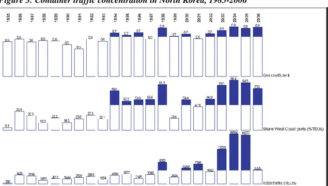
The legacy of contemporary port development in the northern part of the Korean
peninsula directly results in a concentration of traffic on the East coast (Figure 3). However,
the share of the West coast has constantly increased until nowadays. What are the factors
leading to such reversal? Is it only explained by geopolitical change, or is it also related to
internal factors? This phenomenon of concentration shift that is made evident by measuring
Gini coefficient based on container traffic is, primarily, the result of changing political
relations and trade patterns. The loss of socialist trades after the fall of the USSR in 1991
would explain the cease of shipments with Russian neighboring ports such as Vladivostok and
Nakhodka, resulting in the decline of the East Coast. But this cannot account for the
continuous growth of traffic of the country in general. Eventually, North Korea maintained
trade relations with Japan and China, and also with South Korea with which 90% of
shipments use sea transport due to persisting inland blockade at the DMZ. Thus, other factors
shall be researched internally.
The internal changes in the country’s spatial organization and the successive planning
Ocean Shipping Agency (KOSA)2 that is based in Pyongyang is responsible for all
ship-related services, but there is no existing information about the country’s port policy. By
looking at the evolution of urban population of main North Korean cities, existing studies
point at a major demographic concentration in Pyongyang and other western cities (Jo and
Adler, 2002b). This phenomenon of urban primacy, which is typical of developing countries,
may constitute the very cause of the westward shift of port traffic. Because Nampo is the main
port on the west coast and is well connected by road to the core economic region, it has
become the country’s main maritime gateway. From a relatively balanced situation due to the dynamism of both maritime facades, there is a dramatic increase of concentration (0.8) after
1992 onwards. Only a detailed analysis of the weight, composition, distribution, origin, and
destination of port traffic by main period between 1985 and 2005 may shed light on the
respective roles of local and global factors underlying port concentration in North Korea.
Data was calculated in identical ways for each period, based on the agglomerated
vessel movements: traffic volume and composition, direct origin and destination, average
berthing time, average vessel size, and share of North Korean vessels. All indicators express
one aspect of port performance. By complementing the results with other sources and field
study3, the distribution and evolution of this performance shall shed new light on the possible
relations between economic and political factors affecting port concentration.
3.2 Soviet influence: the dominance of East coast ports (1985-1991)
During the heyday of the North Korean economy, traffic is relatively balanced
between East and West coasts of the country (Figure 4). Total traffic is slightly more
concentrated in Nampo, but container traffic clearly indicates the dominance of the East coast.
2
The KOSA is notably responsible for permit delivery, cargo handling management, quay booking, surveying, ship repair and inspection, bunkering and crew salvation, as well as administrative documentation, customs, bills of lading, and receives complains in case of good damage during shipping or stevedoring.
3
Notably, Cheongjin and Rajin have the highest share of regular shipping. This deviates from
the general situation defined by a dominance of bulky products in North Korea. A recent
study estimates the share of raw materials (e.g. mine products) in domestic transport around
71% of domestic transport flows were raw materials (e.g. mine products), carried dominantly
by rail and road that occupied 74% and 18% of the modal split respectively in 1989 (Tsuji,
2005). Their role as important links between Japan and mainland China is notably due to their
advantage as North Korea’s only ice-free ports during winter, in comparison with neighboring
Russian competitors which have less capacity. Indeed, eastern ports show a dominant share of
their traffic with Japan, except for Heungnam and Songjin that are more connected outside
Northeast Asia. Eastern ports also have a lower share of North Korean vessels, showing their
higher degree of openness to foreign trade. Finally, Cheongjin and Rajin have a higher share
of general cargo shipments, probably due to their location in a forestry area but also due to
their role as transit ports. At that period, Wonsan stood by far as North Korea’s largest coastal
petrochemical complex, what is reflected in its large share of tanker traffic and highest
average vessel size. Because of its good inland transport links with Pyongyang and is also an
important naval base, it acquired a strategic commercial and military role for energy storage
and supply, transportation, shipbuilding and repair, and production of railroad rolling stock.
In comparison, the west coast has a rather secondary role in the port system. Of
course, as the gateway to Pyongyang, Nampo has the biggest traffic volume, and a diversified
portfolio in terms of traffic origin and destination. It has a higher proportion of bulk traffic to
cover the needs of Pyongyang for construction materials (e.g. cement), but this is also the case
for ports located nearby large cities (e.g. Heungnam, Cheongjin). Although the problem of
low equipment is already widespread in North Korea during this period, Nampo is
permanently constrained by the West Sea Barrage, completed in 1986, through which vessels
the particularity to suffer more than other ports from political instabilities, due to their
location near the inter-Korean border area. Their higher share of North Korean vessels may
illustrate the tension between North Korea and South Korea, resulting in the limited
permission given to foreign vessels accessing those ports. Indeed, Nampo has developed as a
key military and industrial complex whose proximity with the capital city makes very
strategic. Overall, both façades show relatively high average berthing periods, except for
Wonsan due to the regular ferry link with Niigata, Japan.
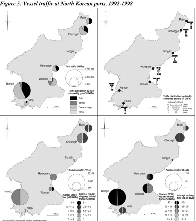
3.3 Isolation: the shift to the West (1992-1998)
The second period (Figure 5) shows a major concentration of traffic at Nampo. East
coast ports have greatly declined. The loss of socialist trades undoubtedly harmed the
relations between eastern ports and former Soviet ports. Heungnam has most declined
probably due to heavier dependence on Soviet trades. Local factors also explain this trend, as
in the case of Wonsan, from which numerous factories were moved in the mid-1990s so as to
create a new and secured military and industrial complex in the mountainous northern areas.
As a result, Wonsan’s total traffic and share of tanker traffic have both greatly reduced. The
deterioration of roads and obstruction of tunnels also started to impact negatively on the
dynamism of Wonsan that is increasingly isolated from the capital region (Roussin and
Ducruet, 2006). In fact, the country is isolated geopolitically, while internal areas have
become less connected internally (Ducruet and Roussin, 2007b).
The decline of the East coast is counterbalanced by some exceptions. For instance, the
special economic zone of Rajin-Seonbong was opened in 1991 as part of the larger United
Nations Tumen River Development Programme, resulting in a higher traffic growth than other
ports. A recent study concluded that such increase was due to the construction of the project
The study also demonstrated that the absence of a manufacturing base would be a better
explanation of the limited success than geographical remoteness and political tensions. Thus,
increased trade flows were mostly explained by land-based traffic with neighboring Chinese
provinces. From the mid-1990s, China started improving Rajin’s road connections while
building new container facilities for improving its access to the Pacific (Cotton, 1996).
Notably, Rajin provides Japan with direct maritime connection to the Trans-Siberia-Railroad
(TSR) and Trans-China-Railroad (TCR). Rajin, Cheongjin, and Wonsan keep the highest
share of regular shipping (that is also high in Heungnam), the first due to their inland
connections with China, while Wonsan maintains its regular ferry service with Niigata,
avoiding too much decline.
Comparatively, the traffic structure of western ports has not much changed since the
previous period. General cargo remains dominant in general, while bulk traffic is more needed
at larger urban and industrial agglomerations. The specificity of Nampo is to have kept a wide
diversity of maritime connections, while other ports are becoming dominantly connected with
Japan. Isolation and geopolitical change provoked a retreat of North Korea from the
international scene, resulting in more short-sea and less long-distance connections, except for
Nampo, the gateway to Pyongyang. Paradoxically, the share of North Korean vessels
remained higher for southern ports due to prolonged political tensions, but it has slightly
reduced in Haeju. Also, the general increase of average berthing time that also reflects North
Korea’s isolation is not matched by Wonsan that keeps privileged relations with Japan through the ferry link. Not only the changes in international trade relations are highlighted,
but also the internal factors that are based on limited openness and self-sufficiency. This
situation was about to change with the growing involvement of China and South Korea in
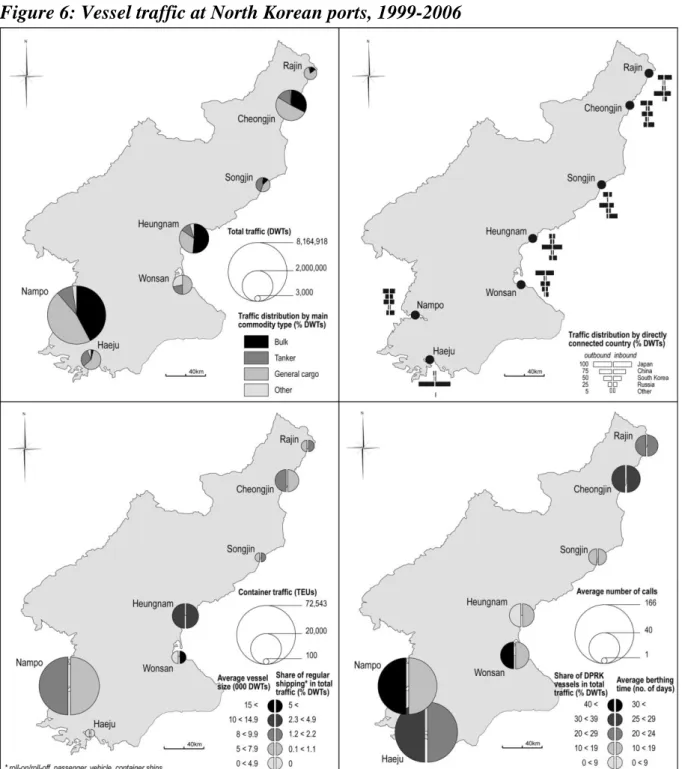
3.4 Chinese and South Korean influence: the dominance of West coast ports (1999-2006)
The last period is marked by important changes in the country’s behavior toward the outside world. Although tensions have been exacerbated due to nuclear crisis and prolonged
embargo, international trade and foreign investments increased substantially after the first
inter-Korean summit of 2000. At the same time, China exerts a growing influence on the
development of North Korea, in the manufacturing and mining sectors for instance, and has
become its leading trade partner with almost 40% of North Korea’s international trade in 2005, while South Korea, the second largest trade partner, occupies 25%.
Nampo maintains its position as North Korea’s main port (Figure 6). While South
Korea’s plans to build a container terminal and freight station in Nampo have failed due to
politics, China has been more successful in supporting the construction of a new container
berth (Lloyd’s Register, 2006). Nampo concentrates most new investments, such as the new
Songgwan terminal (2001) but North Korea’s plan designing the Wawoo port district as a
special economic zone was cancelled (see Figure 2). Other ports have kept declining
dramatically. Heungnam still generates more traffic due to its situation within the large
Hamheung industrial complex. The decline of Rajin confirms the preference for border trade
with China, the limited success of the special economic zone, and the limited use of the port
for transit trade with the Pacific. Another important phenomenon is the dramatic shift of
population and economic activities from East to West in a context of de-industrialization
(Ducruet and Roussin, 2007c). A good example is Haeju’s growth due to sand barging from
the Han River, in cooperation with South Korea. However, the decision made at the second
inter-Korean presidential summit to build a second industrial complex in Haeju has not yet
been implemented.
One of the main impacts of humanitarian aid is the increase of tanker traffic at all
United States’ food and oil assistance. One exception is the case of Songjin where tanker traffic better relates to the KEDO4 project, but the latter was officially cancelled in 2006. The
growth of aid traffic was interestingly supported by a shift of maritime connections towards
South Korean ports, resulting in hub dependence (Ducruet, 2008). South Korean ports are
well located to handle North Korean flows in terms of centrality - proximity to the North
Korean market - and intermediacy - facilitation of transshipment for ocean carriers. This
situation is made evident because of the growing technical discrepancy between northern and
southern ports, and is reinforced by South Korea’s strategy of becoming Northeast Asia’s
logistics hub.
Despite this trend of hub concentration at South Korean ports, important connections
remain with Japanese and Russian ports, notably for East coast ports. For instance, Rajin is
well located for Russian trade, which increased threefold from US $68 million in 2001 to US
$232 million in 2005 (Ministry of Unification in South Korea, 2005). Wonsan has kept
connections with Japan, although trade declined twofold from US $474 million in 2001 to US
$194 million in 2005. Overall, the share of South Korean connections has increased in all
North Korean ports, resulting in an unprecedented share of regular shipping, notably in the
East. Whether caused by the establishment of inter-Korean hub traffic in Heungnam
(Joongang Daily, 2006) or other phenomena, Heungnam welcomes the largest ships on
average. Given the intermingling of aid traffic and inter-Korean shipments, it is difficult to
separate the two processes at stake in North Korean port traffic change.
Some aspects of the North Korean port system have not much changed. Despite trade
growth and openness, the North Korean fleet remains dominant in ports close to South Korea.
This share is high in Nampo despite infrastructure modernization and increased links with the
4
South Korean port of Incheon following the inter-Korean maritime agreement5 of 2005. This
indicates that the army maintains its control on vessel selection at strategically located ports.
The share of North Korean vessels increased in Cheongjin, but this is better explained by its
general decline as it was recently qualified as a dormant port (Pons, 2006). Rajin also showed
a retreat of foreign vessels and an increase of berthing time. The general reduction of long
distance connections (i.e. outside Northeast Asia) marks the continued decline of the country,
while it remains important for Cheongjin and Heungnam only due to humanitarian aid from
developed countries.
Beside changes in trade patterns and geopolitics, one major restrictive factor affecting
East coast ports is the deterioration of the domestic land transport system. The road network is
only 7% paved nowadays; most highways are concentrated in the west around the capital
region, where 20% of the operating factories are located (Bang, 2004). This is confirmed by
the distribution of domestic inland traffic: 30% in the South Pyongan province, 10% in the
North Pyongan province, 24% in the North Hamgyeong province, and 17% in the South
Hamgyeong province (Tsuji, 2005). The lack of inland connectivity between the different
provinces also reflects military concerns: the army keeps a firm control on interurban
movements and plans the road network for defense rather than economic purposes (Roussin
and Ducruet, 2006). Therefore, railways remain the only transportation mode capable of
carrying the goods generated by mines, and of reaching remote, mountainous areas (Tsuji,
2004). The limited internal connectivity has gradually resulted in the concentration of traffic
at Nampo, Pyongyang’s main (and only) maritime gateway, between which the 10-lane Youth
Hero motorway was built in 2000. Overall, this concentration results from the complex
intervention of physical, economical, and political factors on various scales, from the local to
the global.
5
4. Conclusion
The analysis of traffic distribution within the North Korean port system is fruitful in
many ways. It has overcome the scarcity of data that often characterizes constrained and
closed economies. Although measuring traffic in deadweight tonnage or slot capacities cannot
account for the real volumes handled at the docks, the excessive costs that characterize
shipping to and from North Korean ports provide a sufficient argument in favor of
considering those shipments as an indicator of the level and nature of port activities.
This study complements our understanding of port system concentration in general
(see Table 4 for a synthesis). The classic process of economic polarization of the core region
in developing countries is verified in North Korea by the concentration of traffic at one main
load centre, Nampo. North Korean authorities failed to sustain the principle of regional
balance that was based on the polycentric urban system. Before the isolation, the transport
system could provide the capital region with a good access to East and West coasts. Thus,
traffic shift and concentration in North Korea resulted from the impact of geopolitical crisis
rather than from the spatial agglomeration of economic activities.
[Insert Table 4 about here]
Internal political crisis and natural disasters contributed to the dereliction of the
transport system, resulting in disconnection amongst North Korean provinces. As a result, the
core region has become increasingly isolated. Only Nampo and other Western cities located
near the capital city have sustained their activities. Distance and elevation also played an
principles and the search for short-time economic survival provoked concentration in the port
system.
This is why the observed trends affecting the North Korean port system are both
universal and exceptional. On the one hand, the concentration trend shows that North Korea
fits quite well with the general models of port concentration in developing and transition
countries. On the other hand, the North Korean case shows that concentration may occur
despite the absence of economic growth, unlike other countries. Perhaps the peace treaty with
the US and the lifting of the trade embargo in the foreseeable future may pave the way for
further evolution of the port system.
Future research shall develop towards three main directions. First, the international
comparison of port system evolution in constrained economies is necessary to better verify the
uniqueness of particular contexts and their possible common trends. Second, surveying the
interested shipping lines calling at North Korean ports in recent years would improve our
knowledge about the current state of port infrastructures and shipping in North Korea. The
names and contact information of the shipowners are also provided by Lloyd’s database on
vessel movements. Third, a better understanding of North Korea’s internal spatial change
would greatly benefit from active collaboration with non-governmental organizations,
transport companies involved in border trade (e.g. Russian, Chinese), and foreign companies
investing in North Korea (e.g. European).
References
Ahn, M.Y., 2001. Slow boat to North Korea. Cargo News Asia, May 7.
Ahn, C.Y., 2003. North Korea Development Report 2002/3. Seoul: Korea Institute for Economic Policy.
Airriess, C., 2001. The regionalization of Hutchison Port Holdings in mainland China. Journal of
Transport Geography 9(4), 267-278.
Alfonso, H.D., 2001. Local Government and Economic and Social Change in Cuba. Ottawa: Canadian Foundation for the Americas.
Bang, H.K., 2004. Towards an integrated logistics system in northeast Asia. East Asian Review 16, 111-121.
Barke, 1986. Transport and Trade. Edinburgh: Olivier & Boyd.
Basu, D.K., 1985. The Rise and Growth of the Colonial Port Cities in Asia. University of California: Center for South and South East Asian Studies.
Bermudez, J.S., 2006. North Korea’s Strategic Culture. United States: Science Applications International Corporation.
Brodin, A., 2003. Baltic Ports and Russian Foreign Trade: Studies in the Economic and Political Geography of Transition. Gothenburg: University of Gothenburg.
Brunt, B., 2000. Ireland’s seaport system. Tijdschrift voor Economische en Sociale Geografie 91(2), 159-175.
Cargonews Asia, 2007. Russia, China vie for control of North Korean port. March 6.
Charlier, J., 1988. Structural change in the Belgian port system, 1980-1986. Maritime Policy and
Management 15(4), 315-326.
Charlier, J., 1996. The Benelux seaport system. Tijdschrift voor Economische en Sociale Geografie 87(4), 310-321.
Choi, E.K., Kim, E.H., Merill, Y.S., 2003. North Korea in the World Economy. London & New York: Routledge.
Cotton, J., 1996. China and Tumen river cooperation: Jilin’s coastal development strategy. Asian
Survey 36, 1086-1101.
Cumings, B., 2004. North Korea: forgotten nuclear threats. Le Monde Diplomatique, December. De, P., Park, R.K., 2003. Container port system concentration. Transportation Quarterly 57(4), 69-82. Ducruet, C., 2008. Hub dependence in constrained economies: the case of North Korea. Maritime
Ducruet, C., Gélezeau, V., Roussin, S., 2008. Les connections maritimes de la Corée du Nord : recompositions territoriales dans la péninsule coréenne et nouvelles dynamiques régionales en Asie du Nord-Est. L’Espace Géographique 3, 208-224.
Ducruet, C., Jo, J.C., 2008. Coastal cities, port activities and logistic constraints in a socialist developing country: the case of North Korea. Transport Reviews 28(1), 1-25.
Ducruet, C., Lee, S.W., 2006. Frontline soldiers of globalisation: port-city evolution and regional competition. Geojournal 67(2), 107-122.
Ducruet, C. and Roussin, S., 2007a. Corée du Nord: vers l’ouverture des ports maritimes. Journal de
la Marine Marchande 4566, 6-9.
Ducruet, C. and Roussin, S., 2007b. L’archipel nord-coréen : transition économique et blocages territoriaux. Mappemonde 87, http://mappemonde.mgm.fr/num15/articles/art07302.html
Ducruet, C. and Roussin, S., 2007c. The changing relations between foreland and hinterland at North Korean ports. Paper presented at the 6th Inha-Le Havre International Conference, Incheon, Republic of Korea, October 10-11.
Edwards, S., 1993. Openness, trade liberalization, and growth in developing countries. Journal of
Economic Literature 31, 1358-1393.
Frémont, A., Soppé, M., 2007. Port concentration, shipping line concentration and port hierarchy: the example of the northern European range. In: Wang, J.J., Olivier, D., Notteboom, T.E., Slack, B., (Eds), Ports, Cities, and Global Supply Chains. Aldershot: Ashgate, pp. 105-120.
Fujita, M., Mori, T., 1996. The role of ports in the making of major cities: self-agglomeration and hub-effect. Journal of Development Economics 49(1), 93-120.
Ghani, A., 2006. Jakarta to set up 3 new SEZs to boost investments. Strait Times, November 7.
Hankyoreh, 2006. China, N.K. agree to trade zone along border. Hankyoreh,
http://english.hani.co.kr/arti/english_edition/e_international/150123.html
Hayuth, Y., 1981. Containerization and the load center concept. Economic Geography, 57(2), 161-176.
Hilling, D., 1977. The evolution of a port system: the case of Ghana. Geography 62(2): 97-105. Hoare, A.G., 1986. British ports and their export hinterlands: a rapidly changing geography.
Geografiska Annaler 68B(1), 29-40.
Hoyle, B.S., 1974. Spatial Aspects of Development. London & New York: John Wiley and Sons. Hoyle, B.S., 1999. Port concentration, inter-port competition and revitalization: the case of Mombasa, Kenya. Maritime Policy and Management 26(2), 161-174.
Hoyle, B.S., Charlier, J., 1995. Inter-port competition in developing countries: an East African case study. Journal of Transport Geography 3(2): 87-103.
Jacobs, W., Hall, P.V., 2007. What conditions supply chain strategies for ports? The case of Dubai.
Geojournal 68(4): 327-342.
Jackson, G., 1983. The History and Archaeology of Ports. Tadworth: World’s Work Ltd..
Jo, J.C., 2000. The Evolution of Urban and Regional Planning in North Korea: 1945-1998. Unpublished PhD Thesis in Urban Planning, Portland: Portland State University.
Jo, J.C., Adler, S., 2002a. Planning in the socialist developing country: the case of North Korea.
Habitat International 26(2), 251-267
Jo, J.C., Adler, S., 2002b. North Korean planning: urban changes and regional balance. Cities 19(3), 205-215.
Jo, J.C., Ducruet, C., 2007. Rajin-Seonbong, new gateway of Northeast Asia. Annals of Regional
Science 41(4), 927-950.
Joly, O., Lemarchand, A., 2007. Maritime range and regional integration. Paper presented at the International Congress on Ports in Proximity, Antwerp-Rotterdam, December 5-7.
Joongang Daily, 2006. North eyes inter-Korean port in the East. June 14.
Kenyon, J., 1970. Elements in inter-port competition in the United States. Economic Geography 46, 1-24.
Kidwai, A.H., 1989. Ports in a national system of ports and cities. In: Broeze, F., (Ed), Brides of the Sea: Port Cities of Asia from the 16th - 20th Centuries. Honolulu: University of Hawaii Press, pp. 207-222.
Kuby, M., Reid, N., 1992. Technological change and the concentration of the US general cargo port system: 1970-1988. Economic Geography 68(3), 272-289.
Lee, S.W., Song, D.W., Ducruet, C., 2008. A tale of Asia’s world ports: the spatial evolution in global hub port cities. Geoforum 39(1), 372-395.
Lloyd’s Register, 2006. North Korea completes container berth. May 12.
Lo, C.P., 1989. Recent spatial restructuring in Zhujiang delta, south China: a study of socialist regional development strategy. Annals of the Association of American Geographers 79(2), 293-308. Ministry of Unification in South Korea, 2005. Changes in North Korea for the past five years. December 23.
Murphey, R., 1989. On the evolution of the port city. In: Broeze, F., (Ed), Brides of the Sea: Port Cities of Asia from the 16th - 20th Centuries. Honolulu: University of Hawaii Press, pp. 223-245. Notteboom, T.E., 1997. Concentration and load centre development in the European container port system. Journal of Transport Geography 5(2), 91-115.
Notteboom, T.E., 2006a. Traffic inequality in seaport systems revisited. Journal of Transport
Geography 14(2), 95-108.
Notteboom, T.E., 2006b. Container throughput dynamics in the East Asian container port system.
Journal of International Logistics and Trade 4(1), 31-52.
Notteboom, T.E., Rodrigue, J.P., 2005. Port regionalization: towards a new phase in port development.
Maritime Policy and Management 32(3), 297-313.
Ogundana, B., 1971. The location factor in changing seaport significance in Nigeria. Nigerian
Geographical Journal 14, 71-88.
Oh, K., Hassig, R., 1999. North Korea between collapse and reform. Asian Survey 39, 287-309. Pons, P., 2006. Incursion en Corée du Nord. Le Monde, December 4.
Rimmer, P.J., 1967a. The search for spatial regularities in the development of Australian seaports 1861-1961/2. Geografiska Annaler 49B, 42-54.
Rimmer, P.J., 1967b. The changing status of New Zealand seaports, 1853-1960. Annals of the
Roussin S. and Ducruet, C., 2006. Logistic perspectives in DPRK. Paper presented at the Annual Fall Meeting of the Korean Society of Coastal and Ocean Engineers. Seoul: Republic of Korea, September 15-16.
Roussin, S., Ducruet, C., 2007. The Nampo-Pyongyang corridor: a strategic area for European investment in DPRK. Paper presented at the conference on Recent Developments in North Korea and the Role of the European Union. Seoul: Republic of Korea, June 1.
Rozman, G., 2004. Northeast Asia’s Stunted Regionalism: Bilateral Distrust in the Shadow of Globalization. Cambridge: Cambridge University Press.
Slack, B., 1985. Containerisation, inter-port competition and port selection. Maritime Policy and
Management 12(4), 293-303.
Slack, B., 1990. Intermodal transportation in North America and the development of inland load centers. The Professional Geographer 42(1), 236-243.
Slack, B., 1993. Pawns in the game: ports in a global transportation system. Growth and Change 24(4), 579-588.
Slack, B., Wang, J.J., 2003. Port peripheral challenge: an Asian perspective. Geojournal 56(2), 159-166.
Smolensky, E., Ratajczak, D., 1965. The conception of cities. Explorations in Entrepreneurial History 2(2), 90-131.
Stern, E., Hayuth, Y., 1984. Developmental effect of geopolitically located ports. In: Hoyle, B.S., Hilling, D., (Eds), Seaport Systems and Spatial Change. Chichester: John Wiley and Sons, pp. 239-249.
Taaffe, E.J., Morrill, R.L., Gould, P.R., 1963. Transport expansion in underdeveloped countries: a comparative analysis. Geographical Review 53(4), 503-529.
Thant Zin, C., 2007. Russia to build North Korea container terminal. Port World, December 19. Thorez, P., 1998a. Le transport maritime dans les pays issus de l’ex-URSS. Le Courrier des Pays de
L’Est 426, 18-52.
Todd, D., 1993. The interplay of trade, regional and technical factors in the evolution of a port system: the case of Taiwan. Geografiska Annaler 75B(1), 3-18.
Tsuji, H., 2004. Perspectives on Linking the Trans-Siberian and Trans-Korean Railways. Niigata: Economic Research Institute for Northeast Asia.
Tsuji, H., 2005. The Transport Infrastructure of the DPRK. Niigata: Economic Research Institute for Northeast Asia.
Tybout, J.R., 2000. Manufacturing firms in developing countries: how well do they do, and why?
Journal of Economic Literature 38, 11-44.
Vigarié, A., 1995. La Mer et la Géostratégie des Nations. Paris: Economica.
Vinh, T.C., 2004. Development orientations of Vietnam maritime transportation in the next 15 years (2005-2020). Paper presented at the OCEANS’04 MTS/IEEE International Conference, Kobe, Japan, November 9-12.
Wang, J.J., 1998. A container load center with a developing hinterland: a case study of Hong Kong.
Journal of Transport Geography 6(3), 187-201.
Wang, J.J., Slack, B., 2000. The evolution of a regional container port system: the Pearl River Delta.
Journal of Transport Geography 8(4), 263-275.
Yoon, D.R., 2006. Economic reforms and SEZ as survival strategy for North Korea. Seoul: Korea Institute for International Economic Policy.
Yoon, D.R., Babson, B.O., 2002. Understanding North Korea’s economic crisis. Asian Economic
Papers 1, 69-89.
Yoon, M.C., 2008. A new order in East Asia: Mediterranean model. Anyang: Korea Research Institute for Human Settlements.
Table 1: Selected studies on port system concentration, 1963-2008
Author(s), year Year Area Concentration factor(s) De-concentration factor(s)
Taaffe, Morrill & Gould 1963 Africa Inland transport corridors Rimmer 1967a, 1967b Australia, New Zealand Inland transport corridors
Kenyon 1970 United States Metropolitan dominance (New York) Hinterland-foreland changes Hilling 1977 Ghana Spatial consolidation and rationalization
Hayuth 1981, 1988 United States Development of large load centres, intermodalism Peripheral port challenge Slack 1985, 1990 United States Level of intermodalism Port selection by carriers Barke 1986 Congestion, lack of space for further expansion Hoare 1986 United Kingdom European integration, national connectivity
Charlier 1988 Belgium Stable structure of port hierarchy Traffic specialization Airriess 1989 Indonesia through hinterland penetration Exogenous development
Kidwai 1989 India New port construction (bulk) Kuby & Reid 1992 United States Technological innovations, disappearance of smaller
ports
Todd 1993 Taiwan Export-led policy and growth poles Balanced regional development Starr 1994 United States shipping, decreased port calls Economies of scales in liner
Hoyle & Charlier 1995 East Africa Concentration of investments
Charlier 1998 Benelux Hinterland development (railway), port selection (Zeebrugge) Notteboom 1997 Europe Traffic shifts to medium-sized (new) ports
Wang 1998 Hong Kong, China Technological advance of Hong Kong Port competition, congestion, modal shift, high handling costs Hoyle 1999 Kenya Primate city polarization (Mombasa) New port development Brunt 2000 Ireland Metropolitan dominance (Dublin) National development plans Wang & Slack 2000 Pearl River Delta Carriers’ pressures, port policy Slack & Wang 2003 Asia Strategies of transnational operators
De & Park 2003 World Port competition, new technologies Notteboom & Rodrigue 2005 Developed countries Development of ‘off-shore’ hubs and inland terminals
Ducruet & Lee 2006 World Urban growth, regional port competition Notteboom 2006a Europe, North America Stability of concentration
Notteboom 2006b East Asia New port development Ducruet & Lee 2007 Europe Core-periphery pattern Modal specialization of port cities Frémont & Soppé 2007 North European Range Stable traffic concentration Shipping line concentration Joly & Lemarchand 2007 World Regional integration, maritime range, traffic growth maturity National systems, intra-regional trade barriers
Ducruet 2008 Northeast Asia Hub dependence Military control, logistics barriers Ducruet & Rozenblat 2008 World Graph centrality
Lee, Song & Ducruet 2008 Hong Kong, Singapore Technological differentials, efficient planning policy Congestion, lack of space, port competition
Table 2: Ports and maritime trade in socialist and developing countries Issues Socialist country Developing country Modal split Inland transport dominance (70-90%) Maritime transport dominance, low hinterland coverage Port system Traffic specialization (50-90% in one main port) Traffic concentration Port traffics Bulky products, low-valued goods Bulk imports and manufactured goods exports Trade pattern Among socialist partners Extraverted (e.g., free-trade zones)
Equipment Lack of container handling facilities Poor technical standards Governance Centrally planned, bureaucracy and protectionism Cumbersome customs regulations, port and terminal privatization External connections Coastal and short-sea shipping Dependence on external hubs for long-distance shipping Source: authors, compiled from various sources
Table 3: Infrastructure characteristics of North Korean ports
Port Stevedoring capacity (tons) Crane capacity (tons) Number of cranes Berth capacity (000s tons) Total quay length (m) Nautical depth (m) Storage (000s sq.m.)
Main cargo handled
Cheongjin 800 185 12 20 3,700 8.5 ~ 10 N/A General cargo, grain, coal, steel Haeju 240 45 4 10 1,300 7 ~ 12 21.8 Cement, ore, zinc, concentrates Heungnam 400 50 2 20 1,850 6.7 ~ 13 23.3 Fertilizers, magnesium clinker
Nampo 750 170 3 25 2,100 10 ~ 13.5 20.8 Coal, cement, container, ore, grain, sundries Rajin 300 10 1 15 3,300 10 ~ 11 26.0 Coal, fertilizers, timber, sundries Seonbong 200 - - 5 1,500 7 ~ 23 26.0 Crude oil, petrochemical products
Songrim 100 18 1 15 550 10 ~ 11 10.4 Iron ore, coal Wonsan 169 109 5 10 3,400 6.1 ~ 12.8 14.5 Cement, marine products
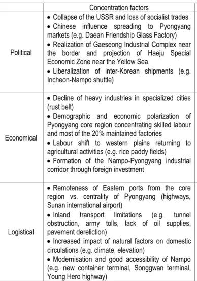
Table 4: Synthesis of port concentration and de-concentration factors in North Korea Concentration factors De-concentration factors
Political
Collapse of the USSR and loss of socialist trades
Chinese influence spreading to Pyongyang markets (e.g. Daean Friendship Glass Factory)
Realization of Gaeseong Industrial Complex near the border and projection of Haeju Special Economic Zone near the Yellow Sea
Liberalization of inter-Korean shipments (e.g. Incheon-Nampo shuttle)
Ideological principle preventing excessive traffic concentration at the core region (Nampo-Pyongyang)
Ports developed under military control for defence rather than economic purpose; entry barriers to foreign ships (e.g. special license)
Geopolitical isolation and trade embargo limiting trade activities and traffic growth
Humanitarian shipments to less accessible populated regions (e.g. Cheongjin, Heungnam)
Economical
Decline of heavy industries in specialized cities (rust belt)
Demographic and economic polarization of Pyongyang core region concentrating skilled labour and most of the 20% maintained factories
Labour shift to western plains returning to agricultural activities (e.g. rice paddy fields)
Formation of the Nampo-Pyongyang industrial corridor through foreign investment
Maintained economic activities of large industrial concentrations outside Pyongyang and prospects for reactivating mines close to seaports (e.g. Danchon)
Resilient proximity trade with Japan and Russia through Eastern ports (e.g. ferry service, fisheries)
Development projects at border and coastal areas (e.g. Sinuiju, Raseon, Tumen, KEDO, Gaeseong, Geumgang, Namyang, Wihwa-Bidan)
Self-contained urban areas relatively independent from the core economic region (socialist planning)
Logistical
Remoteness of Eastern ports from the core region vs. centrality of Pyongyang (highways, Sunan international airport)
Inland transport limitations (e.g. tunnel obstruction, army tolls, lack of oil supplies, pavement dereliction)
Increased impact of natural factors on domestic circulations (e.g. climate, elevation)
Modernisation and good accessibility of Nampo (e.g. new container terminal, Songgwan terminal, Young Hero highway)
Two separate coasts with five main ports in the East and three in the West
Pyongyang traffic dominantly land-based through Sinuiju (80% of North Korean exports)
Technical limitation of the West Sea Barrage for Nampo up to 50,000 DWT and low potential for barging on Daedong River (e.g. sands)
Natural advantage of Rajin as ice-free port and strategic location for Japanese, Chinese, Russian and Mongolian transit trade between Europe and Pacific Source: authors
Figure 1: Transportation nodes and corridors in Northeast Asia
Sources: drawn by authors based on ERINA (2008), Containerisation International (2006), Helders (2008)
Figure 2: Geographical layout of the North Korean territorial and transportation system
Figure 3: Container traffic concentration in North Korea, 1985-2006
Figure 4: Vessel traffic at North Korean ports, 1985-1991
Figure 5: Vessel traffic at North Korean ports, 1992-1998
Figure 6: Vessel traffic at North Korean ports, 1999-2006