HAL Id: hal-00297041
https://hal.archives-ouvertes.fr/hal-00297041
Submitted on 2 Jan 2008
HAL is a multi-disciplinary open access
archive for the deposit and dissemination of
sci-entific research documents, whether they are
pub-lished or not. The documents may come from
teaching and research institutions in France or
abroad, or from public or private research centers.
L’archive ouverte pluridisciplinaire HAL, est
destinée au dépôt et à la diffusion de documents
scientifiques de niveau recherche, publiés ou non,
émanant des établissements d’enseignement et de
recherche français ou étrangers, des laboratoires
publics ou privés.
Hazards of volcanic lakes: analysis of Lakes Quilotoa and
Cuicocha, Ecuador
G. Gunkel, C. Beulker, B. Grupe, F. Viteri
To cite this version:
G. Gunkel, C. Beulker, B. Grupe, F. Viteri. Hazards of volcanic lakes: analysis of Lakes Quilotoa
and Cuicocha, Ecuador. Advances in Geosciences, European Geosciences Union, 2008, 14, pp.29-33.
�hal-00297041�
www.adv-geosci.net/14/29/2008/ © Author(s) 2008. This work is licensed under a Creative Commons License.
Geosciences
Hazards of volcanic lakes: analysis of Lakes Quilotoa and Cuicocha,
Ecuador
G. Gunkel1, C. Beulker1, B. Grupe2, and F. Viteri3
1Berlin University of Technology, Dept. of Water Quality Control, Germany
2Berlin University of Technology, Dept. of Water, Environment and Marine Science and Technology (VWS), Germany 3Universidad Central, Facultad de Geolog´ıa Minas, Petroleo and Medio Ambiente, Quito, Ecuador
Received: 31 July 2007 – Revised: 4 September 2007 – Accepted: 4 September 2007 – Published: 2 January 2008
Abstract. Volcanic lakes within calderas should be viewed
as high-risk systems, and an intensive lake monitoring must be carried out to evaluate the hazard of potential limnic or phreatic-magmatic eruptions. In Ecuador, two caldera lakes – Lakes Quilotoa and Cuicocha, located in the high Andean region >3000 a.s.l. – have been the focus of these investiga-tions. Both volcanoes are geologically young or historically active, and have formed large and deep calderas with lakes of 2 to 3 km in diameter, and 248 and 148 m in depth, respec-tively. In both lakes, visible gas emissions of CO2 occur, and an accumulation of CO2in the deep water body must be taken into account.
Investigations were carried out to evaluate the hazards of these volcanic lakes, and in Lake Cuicocha intensive moni-toring was carried out for the evaluation of possible renewed volcanic activities. At Lake Quilotoa, a limnic eruption and diffuse CO2degassing at the lake surface are to be expected, while at Lake Cuicocha, an increased risk of a phreatic-magmatic eruption exists.
1 Introduction
Caldera lakes of active volcanoes must be regarded as high-risk systems that are strongly influenced by volcanic activi-ties such as gas emission, hydrothermal water inflow and ris-ing magma. Interaction of water with hot volcanic bedrock or magma can pose a high risk of a phreatic-magmatic eruption. A total of forty-seven volcanoes with 275 lake eruptions have been recognized to date (Mastin and Witter, 2000). Caldera lakes also have a hazard potential from gas emissions, includ-ing the mechanism of limnic eruption – the “Lake Nyos phe-nomenon” – being well known; a limnic eruption is a spon-taneous degassing of a CO2-oversaturated deep water body,
Correspondence to: G. Gunkel
triggered by upwelling water. In caldera lakes with increased CO2concentration, diffuse outgassing at the lake surface can occur as well. In addition, the formation of acidic and toxic water due to the emission of such volcanic gases as HF, SO2, HCl and gaseous boron must be taken into account, possibly leading to restrictions on water uses (Hansell et al., 2006; Gunkel et al., 20071).
The natural hazards of volcanic lakes have not yet been sufficiently investigated, and knowledge of volcanic lakes is insufficient. Most caldera lakes are still completely un-known, mainly because of a poorly developed limnology and the lack of capacity for volcanic monitoring in many devel-oping countries.
2 The hazards of volcanic lakes
For any hazard analysis of volcanic lakes, different types and mechanisms of the activity of both the volcanoes and lakes must be distinguished. Well known is the risk of a phreatic-magmatic eruption, triggered by the percolation of surface or lake water into fractures and fissures, where it comes into contact with the hot bedrock or rising magma (Christenson, 2000). The possibility that the high water pressure of deep lakes may promote percolation of water, and the active role of intensive precipitation in triggering volcanic eruptions, are discussed in Matthews et al. (2002). Little is known about this interaction of lake water percolation and volcanic erup-tion, but in some cases it could be verified as a possible trig-gering mechanism for eruptions (Simkin and Siebert, 1994; Mastin and Witter, 2000). Further investigations are neces-sary to get a better understanding of the water balance and the hydrogeological processes of volcanoes. In general, it must 1Gunkel, G., Beulker, C., Grupe, B., and Viteri, F.: Hazard anal-ysis of a caldera lake, lake Cuicocha, Ecuador, Bull. Volcanology, submitted, 2007.
30 G. Gunkel et al.: Hazards of volcanic lakes
Fig. 1. Caldera Lake Quilotoa, Ecuador.
be pointed out that lakes in volcanic active areas, especially of caldera lakes, have a high risk of eruption.
The emission of CO2in volcanically active zones is com-mon, and many reports of its lethal impact on animals and humans are known (Hansell et al., 2006). CO2 is lethal at concentrations of 3% within one hour, and has a narcotic ef-fect, so that people are not aware of, and unable to react to, its effects. A CO2gas cloud has a higher density than air, and will spread out at ground level; a high risk of CO2poisoning exists in caves, small valleys and calderas. The source of CO2can be either direct emission as volcanic gas, or diffuse emission via the lake surface, due to a higher CO2 concentra-tion in the water, which represents a state of oversaturaconcentra-tion in relation to the atmospheric CO2concentration.
The accumulation of CO2 in volcanic lakes is a well known process since the 1986 disaster of Lake Nyos, Cameroon, which spurred intensive international research to analyse the phenomenon of gaseous eruptions (Le Guern and Sigvaldason, 1989, 1990; Kusakabe, 1994; Martini et al., 1994). Under pressure, large amounts of CO2 are soluble in water – at a depth of 100 m, up to 15 l of CO2gas at atmo-sphere pressure in 1 l of water (Colt, 1984). Consequently, significant CO2 accumulation can be achieved only in deep volcanic lakes, but CO2accumulation levels in volcanic lakes are strongly influenced by limnological processes, such as thermal or chemical stratification of the water body (inhibi-tion of lake mixing and degassing of CO2to the atmosphere), such chemical reactions of CO2as the formation and precip-itation of siderite (FeCO3)or calcite/aragonite (CaCO3), and the bacterial reduction of CO2to CH4.
Large amounts of accumulated CO2in a lake can lead to an eruption of the gas, which means water from the depth of the lake moves to the surface due to lake mixing pro-cesses, becomes strongly oversaturated and will degas spon-taneously; this type of eruption is called a limnic eruption and was proven in Lake Nyos (Cotel, 1999).
The water chemistry of volcanic lakes is determined by volcanic activity, and the emission of volcanic gases such as CO, CO2, HF, HCl, SO2and boron compounds, as well as hydrothermal water, can lead to toxic concentrations of some ions, mainly As, B, and F, and to acidic water (introduction of HCl and SO2). Thus, adequate water chemical analyses
are necessary prior to any use of water, even of spring water, in volcanically active areas.
Caldera lakes have no regular outflow, and the water level depends strongly on rain inflow. Intensive and long-term wa-ter inflow can lead to an increase of the wawa-ter level and to a lake overflow – by dam failure or uncontrolled flows over the crater rim, which can trigger lahars.
In general, caldera walls have steep slopes, and the de-posited volcanic debris, ash or lava flows are relatively young and unconsolidated. Thus, the risk of rock falls and land-slides exists, both of which can be triggered by heavy rain or by earthquakes. Landslides and rock falls into the lake can form super-waves and overturn boats and canoes, so that the use of caldera lakes as tourist sites for boating requires adequate monitoring and rescue systems.
3 Hazard analyses of Lakes Quilotoa and Cuicocha
3.1 Volcanic lakes in Ecuador
In Ecuador, two caldera lakes, Quilotoa and Cuicocha, ex-ist in recently active volcanoes in the high Andean region
>3000 a.s.l., which have been the focus of a hazard analysis. Both lakes are large and deep – 2 to 3 km in diameter, and 248 m and 148 m deep, respectively (Fig. 1).
The Quilotoa volcano had an intensive emission of vol-canic ash approx. 800 years ago (Mothes and Hall, 1991, 1998); on some flanks, deposits of >200 m are found. A further series of eruptions followed between 1725 and 1797. After the collapse of the dome during the first eruptive pe-riod, a crater lake developed, in which increased CO2 con-centrations have developed (Aguilera et al., 2000). Some limnic eruptions apparently took place in Lake Quilotoa in 1797, and today, a high risk of a similar future eruption must be taken into account (Mothes and Hall, 1991, 1998).
Cuicocha is a young volcano adjacent to the inactive Pleis-tocene Cotacachi volcano. A series of eruptions with inten-sive ash emission, lahars, and the collapse of the caldera oc-curred between 2900 BC and 700 AD. Over the past few hun-dred years, a caldera lake has developed, with a maximum depth of 148 m. It has been filled by both rain water and hy-drothermal water (Hillebrandt and Hall, 1988; Grupe et al., 20072; Gunkel et al., 20071).
3.2 Volcanic lake monitoring
The basis for any limnological evaluation of a volcanic lake is high resolution bathymetry to detect underwater domes and fractures, and determine the slope of the crater rim, along with any possible instability. This can be done by sonar, used 2Grupe, B., Gunkel, G., Viteri, F., Beulker, C., and von Hille-brandt, C.: The volcano Cuicocha: History and post volcanic ac-tivities, In: Recent and Active Volcanism in the Ecuadorian Andes. Special Issue, J. Volcanol. Geoth. Res., submitted, 2007.
was a sonar type Garmin Fishfinder 250C with double fre-quency (50 and 200 hertz) and a GPS. With a few hundred data per sq. km, good mapping is possible, and can be the ba-sis for a digital elevation model (DEM). The DEM provides a good graphic for visualising the lake’s bathymetry and the topography of the watershed, as well as for documenting any changes in the morphologic features.
The composition of sediments in a volcanic lake must be studied to evaluate the interaction with the overlying water, and the type and amount of sediment is of high significance for lake colmation. For lake-sediment studies, an underwater camera and different types of sediment samplers (Eckman Birge, gravity corer) were used in the Lake Cuicocha study.
Knowledge of the water balance is of great significance for determining the water loss of the lake, for example by perco-lation into fractures and fissures. Volcanic lakes are gener-ally young lakes, with only short time periods for the forma-tion processes of such sediments as carbonate precipitaforma-tion, so that only small amounts of lake sediment have accumu-lated. Thus, the colmation of these lakes must be regarded as weak, and of little stability. In volcanic lakes with insuf-ficient colmation, water loss due to percolation into fractures and fissures can occur.
Lake water is strongly influenced by volcanic or geother-mal activity, and three phenomena for this effect must be dis-tinguished: 1) the leaching of volcanic deposits in the wa-tershed by rain water; 2) the inflow of hydrothermal water (nearby springs or underwater inflow); and 3) the emission of volcanic gases and their dissolution in the water (CO2, HCl, HF, SO2, and boron compounds). The goal of water monitoring must be to determine the significance as well as the possible change of activity of these processes. Physical and chemical data for the water enable the determination of thermal or chemical stratification, the turnover rhythm, and the tendency towards volcanic activity (e.g., water heating due to upwelling magma, increased ionic content due to hy-drothermal inflow, or acidification due to gas emissions).
In many volcanic areas, gas emissions occur, and are used as an indicator of activity. In volcanic lakes, these gas emis-sions are visible only in shallow areas, mainly in the littoral zone; in deep lake areas, gas emissions are only detectable by sonar. Good results were obtained in the presented study with a Garmin Fishfinder 250C, double frequency (50 and 200 hertz; Gunkel et al., 20071).
3.3 The hazard of Lake Quilotoa
Lake Quilotoa, with a salinity of 10.2‰, is strongly influ-enced by hydrothermal water input; present water must be classified as mesohaline. Quilotoa is a weakly stratified lake with no thermocline or chemocline. Rain water input is in-significant, and leads to a decrease in conductivity of only 7% in the upper water body, the epilimnion, which extends down to 25 m. In the epilimnion, inverse density stratifica-tion occurs, due to night cooling with convergence currents,
Fig. 2. Temperature, conductivity, and density profiles of Lake
Quilotoa measured 11 September 2003.
resulting in a mixed water layer down to 60 m, deeper than the epilimnic zone, so called atelomixis. The deep water body, the hypolimnion, is partly mixed due to upwelling wa-ter (rising gas bubbles, hydrothermal wawa-ter input), but with-out complete mixing, and the density increases with water depth (Fig. 2). In the hypolimnion, CO2 concentration in-creases to 0.8 l CO2per litre of water.
In Lake Quilotoa, permanent degassing takes place via diffuse gas emissions from the mixed upper water layer, which is about 60 m deep; CO2 input into this layer oc-curs by observed hydrothermal water inflow (conductivity = 27 900 µS cm−1, salinity = 18.7‰), intensive gas emissions
in the littoral lake zone, and by some mixing with the hy-polimnic water. Rough estimates of the CO2input rate sug-gest that during periods of calm or no wind, toxic CO2gas clouds can form within the caldera and pose a high risk of asphyxiation.. Even spontaneous degassing is possible, trig-gered by density currents after a landslide and an upwelling of hypolimnic water. If this water rises to the surface, it will degas rapidly because of its 40-fold over saturation of CO2 relative to local air pressure. Nonetheless, CO2 accumula-tion in Quilotoa is much less than in Lake Nyos. Compared with the data gathered by Aguilera in 1993 (Aguilera et al., 2000), lake water in 2003 is characterised by increased wa-ter temperature (1T =0.1◦C) and conductivity (1EC=600–
700 µS cm−1), as well as by a drop in the water level of
ap-prox. 20 m (Fig. 3). It was not possible to undertake any dating of ancient water levels. Unfortunately, further inves-tigations have been hindered by possible violence stemming from civil unrest of the native people living around the lake.
32 G. Gunkel et al.: Hazards of volcanic lakes
Fig. 3. Progressive decreases in water level at Lake Quilotoa, as
recorded by calcium carbonate precipitations.
3.4 The hazard of Lake Cuicocha
Lake Cuicocha has no visible continuous inflow and no di-rect outflow, but short-lived occasional heavy rainfalls and the input of surface water from the catchment area feed the lake. Lake Cuicocha also has hydrothermal water inflow, but ionic concentration is still in the range of natural lake water (700 µS cm−1) – this is caused by hydrothermal water
in-flow of relatively low temperature and conductivity (23.5◦C,
2880 µS cm−1). Cuicocha is a typical monomictic lake with
one overturn during the windy dry period. During the course of this overturn, degassing occurs, but no high accumula-tion level of CO2 is observed (0.03 l of CO2/l water). In Lake Cuicocha, regular gas emissions with high intensity were detected at 78 m depth; this gas emission area covers a 500×600 m zone in the western bay of the lake. Addi-tionally, gas emissions happen at three other places, at water depths <10 m. The gas, mainly CO2and N2, is of volcanic origin, due to the occurrence of CO and the accumulation of boron in the lake. There is no risk of a limnic eruption or a CO2gas cloud formation due to diffuse degassing.
After an earthquake in 1987, a rapid water level drop was observed for several weeks, probably caused by damage to the lake’s colmation, totalling approx. 6 m; recently the wa-ter level has been dropping by about 30 cm per year. This is evident along the shoreline of the lake, where dried al-gae and carbonate precipitations record former lake water levels. Thus, a significant amount of the lake’s water, ap-prox. 3000 m3/day, is lost by percolation into fractures and fissures of the bedrock. This water level decrease cannot be explained by reduced rainfall due to climate change, because similar declines in level have not taken place at the nearby lakes of Laguna Mojanda and Lago San Pablo.
Investigations of the sediments using an underwater cam-era and sediment corer were carried out, but sediment
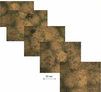
sam-Fig. 4. Sediments of Lake Cuicocha at 78 m depth showing pores
between the rocks and the overlying fine sediment layer.
pling was not very successful in Lake Cuicocha due to sed-iment loss during raising of the equipment. The Cuicocha lake floor consists of rocks, mainly with a diameter of 20 cm, covered by a thin layer of fine anoxic sediments with an oxic surface layer. Cuicocha has calcium-poor sediment, because of a negative calcium carbonate saturation index, which means that calcium dissolution occurs. On the lake floor, pores are recognisable, probably opened by rising gas bubbles and hydrothermal water (Fig. 4). Consequently, the colmation of the lake has been damaged, and the percolation of lake water into fractures under the caldera can occur.
Collectively, the thin sediment layer, the inhomogeneity of the lake floor, and the drop in water level are consistent with the inferred percolation of water into fractures and fis-sures. Such percolation of lake water leads to increased like-lihood of a phreato-magmatic eruption; recently, the effect of water percolation as a trigger mechanism for volcanic erup-tions has been discussed intensively (e.g., Mastin and Witter, 2000; Matthews et al., 2002; Barclay et al., 2006). Thus, in-vestigations of lake colmation and regular monitoring of lake temperature, gas emissions, and increasing hydrothermal ac-tivity must be carried out, together with volcano-monitoring studies of the Cuicocha caldera.
Lake heating (1T =0.1◦C year) and the occurrence of
new underwater inflow of hydrothermal water, registered by divers, indicate increasing activity of the volcano.
4 Concluding remarks
Lakes in volcanic active areas must be the focus of hazard analyses; to date, many of them are not been sufficiently
investigated. However, one challenge is that any change in lake activity is only detectable via special limnological mon-itoring techniques, such as using a lake profiler, under water camera, sonar and, for shallow lakes, SCUBA divers. The feasibility of such lake monitoring has been demonstrated at Lakes Quilotoa and Cuicocha, revealing increased hazards at both lakes, but involving different mechanisms.
Lake Quilotoa shows an atypical water mixture called atelomixis, known only in tropical high mountain lakes (Im-berger, 1985; Gunkel and Casallas, 2002); as a consequence of this frequent partial mixing, degassing of CO2by diffuse emission can occur, and a lethal gas cloud could develop dur-ing periods of calm or no wind in the caldera.
Lake Cuicocha is an example of a lake with insufficient colmation – a common condition for young volcanic lakes. The amount of in situ formed sediments, mainly carbonates and organic material, is small, and a re-opening of the colma-tion layer can be caused by earthquakes or rock slides. Per-colation of lake water into fractures and fissures could lead to contact of that water with hot bedrock or rising magma, thereby increasing the risk of a phreatic magmatic eruption.
Edited by: P. Fabian
Reviewed by: R. Tilling and an anonymous referee
References
Aguilera, E., Chiodini, G., Cioni, R., Guidi, M., Marini, L., and Raco, B.: Water chemistry of lake Quilotoa (Ecuador) and as-sessment of natural hazards, J. Volcanol. Geoth. Res., 97, 271– 285, 2000.
Barclay, J., Johnstone, J. E., and Matthews, A. J.: Meteorological monitoring of an active volcano: Implications for eruption pre-diction, J. Volcanol. Geoth. Res., 150, 339–358, 2006.
Christenson, B. W.: Convection and stratification in Ruapehu Crater Lake, New Zealand: Implicaations for Lake Nyos-type gas re-lease eruptions, Geochem. J., 28, 185–197, 1994.
Colt, J.: Computation of dissolved gas concentrations in water as functions of temperature, salinity, and pressure, American Fish-eries Society, Special Publication 14, 155 pp., 1984.
Cotel, A. J.: A trigger mechanism for the Lake Nyos disaster, J. Volcanol. Geoth. Res., 88, 343–347, 1999.
Gunkel, G. and Casallas, J.: Limnology of an equatorial high moun-tain lake – Lago San Pablo, Ecuador: The significance of deep diurnal mixing for lake productivity, Limnologica, 32, 33–43, 2002.
Hansell, A. L., Horwell, C. J., and Oppenheimer, C.: The health hazards of volcanoes and geothermal areas, Occup. Environ. Med. 63, 149–156, 2006.
Imberger, J.: The diurnal mixed layer, Limnol. Oceanogr., 30, 737– 770, 1985.
Le Guern, F. and Sigvaldason, G. E.: The Lake Nyos event and natural CO2degasing I, Special issues, J. Volcanol. Geoth. Res., 39, 2–3, 1989.
Le Guern, F. and Sigvaldason, G. E.: The Lake Nyos event and natural CO2degasing II, Special issues, J. Volcanol. Geoth. Res., 42, 4, 1990.
Martini, M., Giannini, L., Prati, F., Tassi, F., Capaccioni, B., and Ioizzelli P.: Chemical characters of crater lakes in the Azores and Italy: the anomaly of Lake Albano, Geochem. J., 28, 173–184, 1994.
Mastin, L. G. and Witter, J. B.: The hazards of eruptions through lakes and seawater, J. Volcanol. Geoth. Res., 97, 195–214, 2000. Matthews, A. J., Barclay, J., Carn, S., Thompson, G., and Alexan-der, J.: Rainfall-induced volcanic activity on Montserrat, Geo-phys. Res. Lett., 29, 13, 22-1–22-4, 2002.
Mothes, P. and Hall, M. L.: El paisaje interandino y su formaci´on por eventos volcanicos de gran magnitude, Estudios de Geograf´ıa 4, 19–38, 1991.
Mothes, P. and Hall, M. L.: Quilotoa’s 800 y BP Ash: A valuable stratigraphic marker unit for the integration period, in: Activi-dad Volc´anica y pueblos precolombinos en el Ecuador, edited by: Mothes, P., Abya-Yala, Quito, 111–138, 1998.
Simkin, T. and Siebert, L.: Volcanoes of the world, Geoscience Press, Tuscon, AZ, 349 pp., 1994.
von Hillebrandt, C. and Hall, M. L.: Mapa de los Peligros Volc´anoicos Potenciales Asociados con el Volc´an Cuicocha, Esc. 1:50.000, Escuela Polit´ecnica Nacional, Quito, Instituto Ge-ogr´afico Militar, 1988.