HAL Id: halshs-01066745
https://halshs.archives-ouvertes.fr/halshs-01066745
Submitted on 22 Sep 2014
HAL is a multi-disciplinary open access
archive for the deposit and dissemination of
sci-entific research documents, whether they are
pub-lished or not. The documents may come from
teaching and research institutions in France or
abroad, or from public or private research centers.
L’archive ouverte pluridisciplinaire HAL, est
destinée au dépôt et à la diffusion de documents
scientifiques de niveau recherche, publiés ou non,
émanant des établissements d’enseignement et de
recherche français ou étrangers, des laboratoires
publics ou privés.
Janauri and Chandigarh anticlines in the Siwalik
foothills, northwest India
Bernard Delcaillau, Jean-Michel Carozza, E. Laville
To cite this version:
Bernard Delcaillau, Jean-Michel Carozza, E. Laville. Recent fold growth and drainage development:
The Janauri and Chandigarh anticlines in the Siwalik foothills, northwest India. Geomorphology,
Elsevier, 2006, 76, pp.241-256. �10.1016/j.geomorph.2005.11.005�. �halshs-01066745�
Recent fold growth and drainage development: The Janauri and
Chandigarh anticlines in the Siwalik foothills, northwest India
Bernard Delcaillau
a,*, Jean-Michel Carozza
b, Edgard Laville
aa
UMR-CNRS 6143 T Morphodynamique Continentale et Coˆtie`re r Universite´s de Caen, Esplanade de la Paix, BP 5186, 14032 Caen Ce´dex, France
b
Universite´ L.Pasteur Faculte´ de Ge´ographie 3, rue de l’Argonne F-67083 Strasbourg Cedex, France Received 15 June 2005; received in revised form 20 July 2005; accepted 24 November 2005
Available online 19 January 2006
Abstract
The active growth of a fault-and-thrust belt in frontal zones of Himalaya is a prominent topographical feature, extending 2500 km from Assam to Pakistan. In this paper, kinematical analysis of frontal anticlines and spatial mapping of active faults based on geomorphological features such as drainage pattern development, fault scarps and uplifted Quaternary alluvial fans are presented. We analyse the geomorphic and hydrographic expressions of the Chandigarh and the Janauri active anticlines in the NW India Siwaliks. To investigate the morphological scenario during the folding process, we used spatial imagery, geomorphometric parameters extracted from digital elevation models and fieldwork. Folding between the Beas and Sutlej Rivers gives clear geomorphological evidence of recent fold growth, presumably driven by movements of blind thrust faults. Structural style within the Janauri and Chandigarh anticlines is highly variable (fault-propagation folds, pop-up structures and transfer faults). The approach presented here involves analysis of topography and drainage incision of selected landforms to detect growth of active anticlines and transfer faults. Landforms that indicate active folding above a southwest-dipping frontal thrust and a northeast-dipping back-thrust are described. Along-strike differences in ridge morphology are measured to describe the interaction of river channel patterns with folds and thrust faults and to define history of anticline growth. The evolution of the apparently continuous Janauri ridge has occurred by the coalescence of independent segments growing towards each other. By contrast, systematic drainage basin asymmetry shows that the Chandigarh anticline ridge has propagated laterally from NW to SE.
D 2005 Elsevier B.V. All rights reserved.
Keywords: Fold growth; Active tectonics; Drainage basins; Stream networks; Geomorphometry; Siwaliks; NW India
1. Introduction
Considerable progress has been made in recent years in defining frontal fault-propagation fold growth in regions of active tectonics. Topography and drainage patterns in regions of active deformation reveal aspects of faults and anticline growth (Tate et al., 2001; Med-wedeff, 1992; Mueller and Talling, 1997; Delcaillau et
al., 1998; Delcaillau, 2004; Burbank and Anderson, 2000; Husson and Mugnier, 2003; Sung and Chen, in press; Gupta and Ellis, 2004). The analysis of the relationships between active tectonics and surface pro-cesses/landforms reveals variations in the style of de-formation and in the rate and direction of propagation of ridges. Nucleation, growth and lateral propagation of thrust faults interact with erosion to create the long-term drainage patterns (Elliott, 1976; Gupta, 1997; Champel et al., 2002). Drainage pattern has the potential to record evidence of the kinematics of folds and faults
0169-555X/$ - see front matterD 2005 Elsevier B.V. All rights reserved. doi:10.1016/j.geomorph.2005.11.005
* Corresponding author.
(Jackson et al., 1998). As landforms evolve due to the growth of frontal anticlines, drainage patterns adapt to modifications in surface slope (Keller and Pinter, 1996;
Jackson et al., 1998). Thus, frontal anticlines above active thrust faults display drainage anomalies and knickpoints on longitudinal profiles of stream channels.
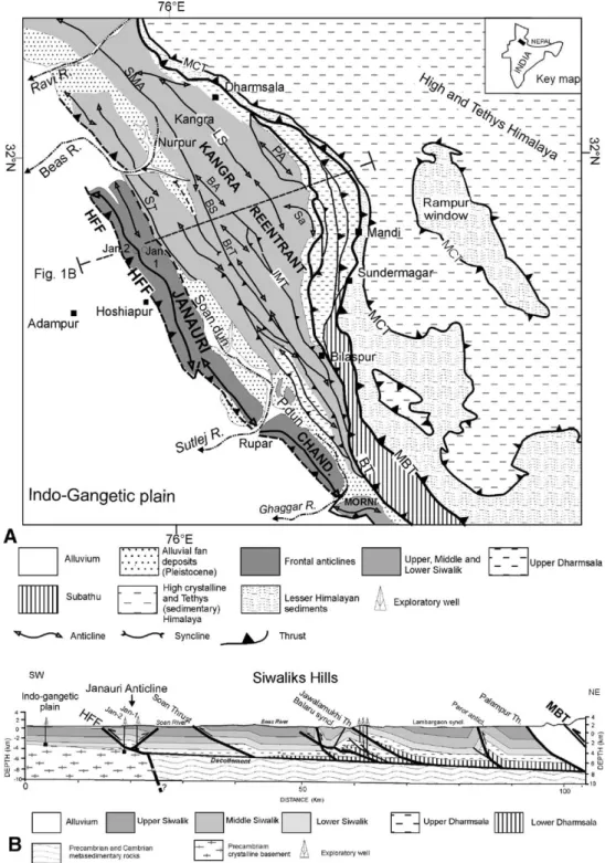
Fig. 1. Geological map of part of Siwalik (NW India) (adapted fromPowers et al., 1998). (A) Geological map of part of the Sub-Himalaya. MCT: Main Central Thrust, MBT: Main Boundary Thrust, HFF: Himalayan Frontal Fault, ST: Soan Thrust, BT: Bilaspur Thrust, BS: Balaru syncline, BrT: Barsar Thrust, LS: Lambargaon syncline, Sa: Sarkaghat anticline, PA: Paror anticline, P dun: Pinjore dun, CHAND: Chandigarh anticline, Jan1 and Jan2: wells. (B) Structural cross section (location in A).
In short, the fluvial drainage system is a highly sensi-tive indicator of acsensi-tive tectonics (Schumm, 1986).
In this study, we investigate the tectonic geomor-phology of active folding over buried reverse faults in the NW India Siwaliks. The study focuses on the geomorphic and hydrographic expressions of the Chandigarh and the Janauri active anticlines (Fig. 1). We use along-strike differences in ridge morphology and drainage pattern to define the geometric evolution of these two frontal anticlines. Much of this analysis has been carried out using GIS (STRM, 90 m spatial resolution). The DEM data are used for extraction of topographic and drainage profiles, indicating changes in the topographic expression of Janauri and Chandi-garh anticline ridges. These anticlines are wrinkle ridges, typically interpreted as fault-related folds formed above blind and emergent thrusts (Watters, 1988). In the foothills of frontal Himalaya, the growing anticlines and Himalayan Frontal Thrust (HFT) take up a significant part of the convergence (e.g. Delcaillau, 1992; Lave´ and Avouac, 2000). Nevertheless, the Plio-Quaternary evolution of the frontal Siwalik hills in NW India is poorly constrained, and the sense of movement in Quaternary times remains a matter of debate (Nakata, 1972; Nakata, 1989; Kumar et al., 2001; Valdiya, 2001). Geological evidence of active faulting is limited to the Himalayan Frontal Fault (Nakata, 1972; Valdiya, 2003; Thakur, 2004; Gupta and Ellis, 2004).
The aims of the study are to document the tectonic geomorphology of the anticline belt, the drainage sys-tems and the structures that accommodate lateral prop-agation on folds.
2. Geological setting (Fig. 1)
The Himalaya range is the result of continental convergence between the Eurasian and Indian plates at rates varying from 44 to 61 mm/year (Minster and Jordan, 1978). The relief is a product of an imbricated thrust sheet (Schelling and Arita, 1991). Each moun-tain range correlates with a thrust sheet of the Main Central Thrust (MCT), the Main Boundary Thrust (MBT) and the Himalayan Frontal Thrust (HFT), which delineates the northern limit of the exposed Indian Plate. The active front of the Himalaya has migrated sequentially from the MCT to the MBT and then the HFT (Schelling and Arita, 1991; Delcaillau, 1992). The Siwalik–Ganges foreland basin constitutes a unique present-day active foreland system in a geo-dynamic context of intracontinental collision, where synorogenic sediments are incorporated into the outer
part of the orogenic belt (Fig. 1A). The northern edge of the foreland basin is deformed and constitutes the Sub-Himalayan zone. It is formed by a succession of parallel and linear anticline ridges where their height varies from 600 m to 1500 m. The Siwalik strata exhibit complex deformation (fault-propagation folds and thrusts). Across the Sub-Himalaya of NW India, a line-length balanced section shows a minimum short-ening of 23 km (Powers et al., 1998). The width of the Siwalik area indicates a great variation due to the sinuosity of the Main Boundary Thrust. The Himala-yan Frontal Thrust (HFT), separating the Siwalik hills and the Indo-Gangetic plain, is a southwest-vergent thrust fault. The HFT cuts Siwalik strata at the surface but is often a blind fault (Nakata, 1989). Several transverse lineaments detected in satellite imagery sug-gest segmentation of Himalayan frontal belt into dif-ferent blocks (Banerjee, 2002). Rising anticline ridges of synorogenic Siwaliks deposits are separated from the main range front by longitudinal tectonic depres-sions called dun valleys.
The study area is located in the India Sub-Himalaya between the Beas River and the Ghaggar River. The Janauri and Chandigarh ridges constitute the Outer Siwalik Range. Beneath the Janauri anticline (Jan in
Fig. 1B), the surface thrust faults merge downward into a decollement horizon of shales of the middle Cenozoic Dharmsala molass (~ 2.58, Powers et al., 1998; Yeats and Lillie, 1991). The basement offset controls the location of structures within the Siwalik hills and causes ramping of the decollement (Wiltschko and Eastman, 1983) (Fig. 1B). The GPS data show that the frontal thrust fault is locked with the advancing Indian plate along the decollement surface, at depths of 6–10 km (Banerjee and Bu¨rgmann, 2002). In the frontal zone, along Ghaggar River and around Chandi-garh, reverse faults with the length varying from 2 to 10 km have displaced Quaternary terrace levels (Malik et al., 2003). These active faults give a slip rate of about 1.6 F 0.1 mm/year.
3. Methodology
In this paper, we use the morphometrical indices like indicators of the morphological response to recent tec-tonic activity. As pointed out by Jackson and Leeder (1994), the shape and the structure of the drainage constitute a response to the uplift process, more or less modulated by lithological parameters. The recon-stitution of the drainage pattern, combined with a de-scription of the geometry of the tectonic structures, elucidate the evolution of a frontal anticline belt.
Here, the morphometric data are not treated from a statistical point of view to determine an average state of the drainage system, but are spatialized in order to high-light the relative timing and the propagation of the anticline using a geographical information system. GIS is used to manage geodata such as digital elevation models (DEM) or remote sensing image and derived spatial information (drainage basin, drainage network and associated properties). DEM data used for this work result from Shuttle Radar Topographic Missions (SRTM). Details on acquisition methodology can be found inFarr and Kobrick (2000). The spatial horizontal resolution of the DEM is around 90 m. The vertical average precision of SRTM DEM is about 7 m in this zone. Taking into account the size of the Janauri and Chandigarh anticlines (respectively 150 km and 50 km length) and that of basin drainage (average size around 20 km2), this resolution is sufficient for a good descrip-tion of the anticline ridges and for a quantificadescrip-tion of landforms. The DEM was used in association with re-mote sensed image (Ortho-rectified Landsat Enhanced Thematic Mapper) compressed Mosaics as displayed by NASA’s Earth Science Enterprise Scientific Data
Pur-chase Program. Delimitation of the morphological units was performed by threshold application on slope and azimutal maps derived from the DEM and confirmed by confrontation with hydrographic network and associated drainage basins automatically derived from the DEM. These data are used to consider the shape and organiza-tion of the drainage or to calculate various morphometric indices. Details of the indices used are show inTable 1. The hydrographic networks were ordered according to the Horton’s method (Horton, 1945). The longest segment of each elementary basin is then used to auto-matically extract the topographic longitudinal profiles from the rivers and to seek breaks in slope. Such knick-points are potential indicators of the uplift of the anti-cline. The prominent drainage is then used to seek an indicator of the propagation of the deformation. Indeed, simulations by cellular automata have show that the development of the asymmetry of the drainage basins could be regarded as a good indicator of the differential uplift along a morphostructure and propagation of the deformation (Rebeiro-Hargrave, 1999; Salvany, 2004). In this study, we characterize the asymmetry of the drainage by using Cox’s (1994) method. This one is
Table 1
Geomorphometric parameters of topography and drainage pattern
Variables Symbols Acquisition methods
Topographical variables of the anticline belt
Length Lb Data extracted from DEM
Width lb Data extracted from DEM
Amplitude DH Data extracted from DEM
Index of asymmetry of limbs Computed from DEM extracted data Mountain front sinuosity Smf = Lmf / Ls (Bull and McFadden, 1977) (1) Computed from DEM extracted data
Main slope of limb S Computed from DEM extracted data
Variables of erosional landforms Drainage basins
Nombre de bassin Data extracted from DEM
Area Au Data extracted from DEM
Basin relief H Data extracted from DEM
Integral hypsometric (Strahler, 1952) (2) Computed from DEM extracted data Index of asymmetry AF (Cox, 1994) (3) Computed from DEM extracted data Elongation ratio Re (4) Computed from DEM extracted data Drainage networks
Physiography of drainage pattern (parallel, treillis, radial, etc.)
Data extracted from DEM
Order Nu Data extracted from DEM
Drainage density Du (5) Computed from DEM extracted data (1) Smf: Lmf/Ls (Lmf: length of the mountain front along the mountain–plain junction; Ls: the straight-line length of the mountain front) (Bull and McFadden, 1977).
(2) The hypsometric curve is defined to divide the heights and areas by the total heights and total area, respectively. Hypsometric analysis has been performed to summarize the form and evolution of drainage basins.
(3) AF = 100. (Ar / At), AF is the index, Ar is the right hand side of the drainage basin, looking downstream, and At is the total area of the basin (Cox, 1994).
(4) Re = (2 A / p) / Lb (A: area, Lb: length of the basin).
based on the computed index of asymmetry (AF), which can be calculated at each point of the hydrographic network. Asymmetry is defined as the position of the drainage within the basin and can be represented as a vector indicating direction of the folding. Repeated sim-ilar deviation can thus be interpreted as propagation. Moreover, we use the hypsometric integral (Strahler, 1952) like a complementary index to characterize the degree of dissection of the relief. The spatial organiza-tion of these values is also used like a proxy of the propagation of the uplift.
4. Geomorphic response to active tectonics of the Janauri and Chandigarh frontal anticlines
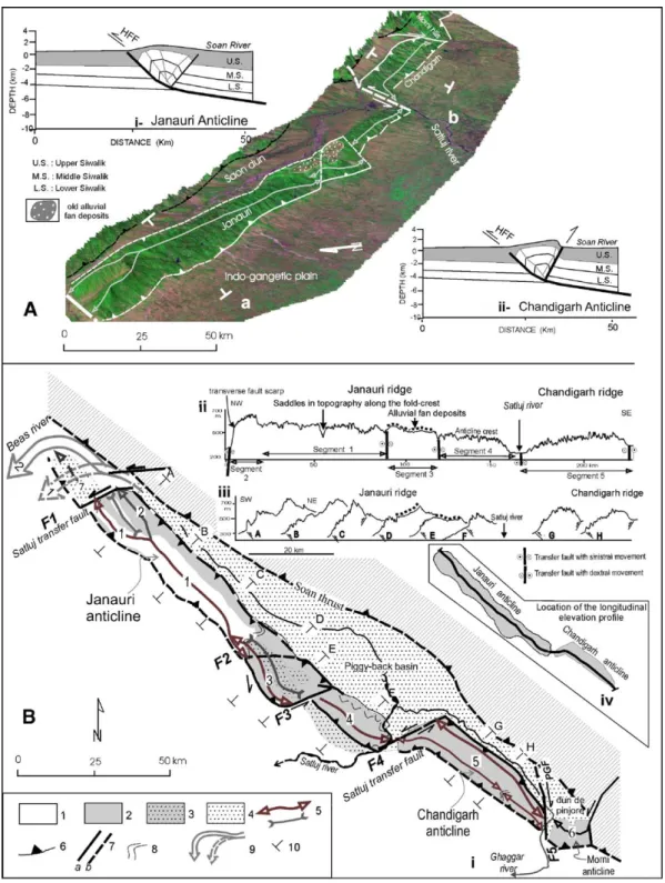
The Siwalik hills in NW India exhibit two anticlines: Jaunari and Chandigarh ridges (Figs. 1A and 2A). This belt of NW trending anticline ridges is about 150 km long and up 10–15 km wide, with summit elevations reaching 700 m above the Indo-Gangetic plain. These elongate ridges are interpreted as anticlines above a southwest-vergent subsurface thrust fault (Yeats and Lillie, 1991). In fact, this anticline belt is part of an active fault-related anticline system located on the hanging wall of the thrust fault along the southern front of the Siwalik hills. The geometry of the Januari anticline is constrained by deep bore hole data and the main structures are well known (Yeats and Lillie, 1991; Brozovic and Burbank, 2000). The anticlines are com-posed of Middle Siwaliks sandstones (Upper Miocene), Upper Siwaliks conglomerates (Pliocene to Lower Qua-ternary) and post-Siwaliks deposits (alluvial fan and terrace deposits). Near the Sutlej River, the thickness of the Upper Siwalik strata is about 2300 m ( Karuna-karan and Ranga Rao, 1976). The foothills are charac-terized by regional curvatures of the deformation front, which deviates from the general trend of thrust units of the Sub-Himalaya. The Janauri and Chandigarh fold belt is considered to be one of the most active structures of the Himalayan front. Forming a right-stepping ech-elon pattern, the NE–SW trending tear fault registered dextral displacement, while the less common N–S-ori-ented faults were characterized by sinistral movement (Fig. 2Bi). Several large earthquakes occurred along blind ruptures of the northwest Himalaya marked by the Saon and Pinjore duns, which themselves are con-trolled by main Siwalik frontal anticlines (Molnar and Pandey, 1989). The Pinjore Garden fault (PGF), strik-ing NNW–SSE, cuts through the piggyback Pinjore Dun (Malik and Nakata, 2002) (Fig. 2Bi).
The Jaunari and Chandigarh anticlines, 150 km and 50 km long, respectively, run parallel to the Soan and
Pinjore duns from NW to SE (Fig. 2Bi). These duns include thick alluvial fans. In the Pinjaur dun, the fan sedimentation was initiated well before 57 ka and con-tinued up to 20 ka BP (Suresh et al., 2002). The Quaternary alluvial fan deposits of Pinjaur Dun indicate erosion of the elongated relief caused by the Soan thrust activity (Fig. 1B).
4.1. Geomorphic response to active tectonics of the segmented Janauri ridge
Janauri ridge is long, linear to sinuous topographic highs. This anticline, located between the Saon and the Satluj Rivers, is interpreted as a fault-propagation fold which is kinematically linked to the HFT (Fig. 2A). In the NW fold belt, the geometry of the deep structure is constrained by two wells (Fig. 1B) (Powers et al., 1998). The symmetric and moderate amplitude folds are caused by the HFT fault that roots in the Lower Dharmsala Fm. The double vergent Janauri anticline, bounded by the HFT and a backthrust, is a pop-up structure (Fig. 1B). Mapping of emergent backthrust suggests a double wedge geometry.
Towards the southeast of the Janauri anticline, the crestal domain of the anticline is particularly narrow. It must be emphasized that this ridge presents an asymmet-rical aspect (cross section F,Fig. 2Bii) This establishes that the southwest vergent anticline corresponds to fault-propagation fold. In the frontal zone, the thrust-fault scarp, reaching a height of ~ 200 m, is associated with the growth of the fold. The alluvial fan deposits seal the frontal thrust. The presence of straight southwest- and northeast-topographic scarps indicates emerged thrust-fault segments. In some cases, the sinuosity of the inter-fluve line controls the Janauri crest asymmetry. The streams on the steep flanks have eroded headwards of the ridge crest in a number places (Fig. 2Bii). The southwestern limb of the anticline has steep slopes and small catchments.
Sections drawn through the Janauri fold indicate an abandoned alluvial fan across the anticline ridge (Fig. 2B). The ridge axis is horizontal in its central part but is inclined gently to the southwest and its northeast (Fig. 3B). The culmination of anticline is an elevated plateau rising up to 150–200 m over the actual fluvial deposits of the Indo-Gangetic plain. In the syncline of the seg-ment 3 (Fig. 2Bi), a perched fan surface can be traced through the fold, implying ~ 150 m of uplift has oc-curred across the fold since the frontal thrust and the backthrust. The converging of rivers a and h in the Soan dun (Fig. 3B) could be controlled by the transfer fault F2 shifting the HFT (Fig. 2B).
Fig. 2. Structures of the Janauri and Chandigarh anticlines. (A) DEM of the anticline ridges GIS (STRM, 90 m spatial resolution); (i and ii) structural interpretation of the Janauri and Chandigarh anticlines. (B) Structural pattern of the Satluj area; (i) structural map of the Janauri and Chandigarh ridges; (1) Middle Siwalik sandstones (Upper Miocene), (2) Upper Siwalik conglomerates (Pliocene and Lower Pleistocene), (3) uplifted and tilted Quaternary alluvial fan deposits, (4) actual alluvial deposits in piggy-back basins (duns), (5) modern alluvial fan deposits in the Indo-Gangetic plain, (6) anticline and syncline axis, (7) thrust, (8) fault (a: known, b: inferred), (9) bedding, (10) avulsion of the stream river, (11) location of the topographic cross-sections in Bii; PGF: Pinjore Garden fault. (ii) Longitudinal summit elevation profiles along the ridge crests; (iii) transversal topographic profiles; (iv) location of the longitudinal elevation profile in Bii.
The segmented folds, apparently continuous, consist of several discrete transfer faults that are distinguished by small lateral offsets and by changes in strike. The Janauri ridge is bounded by NE–SW transverse faults (F1, F2, F3, F4 and F5,Fig. 2B). These transfer faults have a profound effect on the growth of the anticline ridge. The northwestern part of the segment 2
com-prises a transverse fault scarp forming the periclinal of the anticline. That scarp is characterised by a high amplitude relief (~ 500 m) (Fig. 2Biii), a long straight topographic scarp and facets spurs in its northeast part. It is striking that this transfer fault shifts the uplifted alluvium plain (segment 7, Fig. 2B). Strong morpho-logical variability of the Janauri ridge indicates
anti-Fig. 3. Drainage pattern of the Janauri anticline. (A) Drainage network; i, ii, iii, iv and v are different drainage networks; (B) diverted drainage pattern, simplified geological cross-sections and longitudinal profiles of two rivers (a and h).
cline segments (Fig. 2Bii). The fold segmentation is indicated in Middle and Upper Siwaliks bedding, from deflection and various altitudes of topographic axis, and
anomalies of the drainage network (Fig. 4A). Four segments and their linkage are expressed in the active ridge crest morphology. Linearly, the elevation profile
Fig. 4. Drainage map of Janauri anticline. (A) Drainage network and asymmetry of drainage basins with asymmetry vector of watersheds (method of
Cox, 1994). The different numbers (1, 2, 3, 4, 5 and 6) denote longitudinal profiles of rivers. On long river profiles, arrows and discontinuous lines denote knickpoints, which indicate active tectonics. (B) Development of an asymmetrical drainage basin and lateral migration of the folding (localization in the map of A).
is characterized by saddles (Fig. 2Bii). Segment bound-aries coincide with overlapping thrust faults and in regions where fault tips have propagated towards one another.
4.2. Geomorphic response to active tectonics of the asymmetrical Chandigarh ridge
The NW trending Chandigarh ridge, located be-tween the Satluj and Ghaggar Rivers, is about 50 km long and up 6–10 km wide, with summit elevations reaching 600 m above the Indo-Gangetic plain (Fig. 2). Its surface is about 302 km2. The geometry of the frontal thrust is not constrained by seismic data or deep borehole data. As opposed to the Janauri anticline, the Chandigarh ridge is more pronounced in its asym-metry. The width of the frontal flank is about 5 to 10 times larger than the backlimb. The main divide is located several kilometers behind the fold axis (Figs. 6a and 7a). Streams draining the frontal flank are deeply incised into Upper Siwalik conglomerates bed-rock. The ridge presents a strongly dissected topogra-phy. The major rivers trend NE–SW cutting deep V-shaped valleys. Linear gullies with steep walls and landscape scars form a quasi-permanent extension of the strongly drainage network. In contrast, streams draining the northeast-facing backlimb are short (mean length ~ 2 km). These features suggest a marked disjunction between the positions of the fold axis and the drainage divide. From satellite imagery, the pres-ence of a long and straight northeast-facing topographic scarp indicates a steeply dipping fault and a strong asymmetry of the ridge. The length of this sharp scarp is 50 km and its width varies between 1 and 4 km. The amplitude of this relief is ~ 100–300 m and its slope is N45%. From a morphological point of view, this scarp is mainly due to a backthrust fault. Homoge-neous lithology, high drainage density, steepness of small streams and lower sinuosity of an abrupt scarp, approaching 1.0, are geomorphic features related to the uplift and the dissection of an highly tectonically active mountain front.
5. Responses of the drainage basins to the Janauri and Chandigarh anticlines growth
In the front of the propagating thrust, along-strike variations in the anticline have been inferred from hydrological and morphological markers. In this study, detailed investigation of the drainage pattern reveals their active migration into the limbs of the anticlines. We have used morphometric methods to
evaluate direction of the growing anticlines. The drain-age divide is perpendicular to the streams on both of its flanks. The southwestern and northeastern forelimbs are characterized by dendritic drainage pattern. Some sec-ondary tributaries are elongated and are at right angles to primary tributaries. Streams draining the ridges are deeply incised into friable, poorly consolidated Plio-Quaternary conglomerates and sandstones (Upper Siwalik Fm). We describe a local fluvial system specific to each fold segment.
5.1. Streams response of the Janauri ridge anticline growth
One of the most remarkable features of drainage networks in active fold-and-thrust belts is the occur-rence of transverse rivers cutting the axial line of anti-clines (Burbank and Anderson, 2000; Delcaillau, 2004). In the NW India, the Satluj River flows in a longitudi-nal course from NW to SE in the Soan dun (Fig. 1A). The Beas and Satluj Rivers are diverted around of the northwest and southeast ends of the Janauri anticline (Fig. 3A). Rivers incise through the limbs of the ridge anticline. The drainage network displays a parallel pat-tern normal to the Upper Siwalik conglomerate bed-ding. Streams on forward limbs have eroded headwards considerably to produce a sinuous divide.
The dense dendritic drainage network coincides with the steep flank to the Janauri fault-propagation anti-cline. In the southwestern limb, the streams are highly eroded headwards. The stream networks are developed on the two limbs of the Janauri anticline as marked asymmetric drainage basins in the right bank (forelimb) and the right bank (hinterland) of rivers. Many of the rivers and streams, which cross the thrust and back-thrust scarps, show breaks in their longitudinal profiles. Knickpoints along channels cut the southwest and northeast scarp (Fig. 4A).
Neotectonic features are emphasized by asymmetry and drainage anomalies. First, the asymmetry of the anticline is more pronounced in the southeastern zone (cross-section F,Fig. 2Biii). The southwestern limb of the ridge is subjected to a strong fluvial erosion. The major rivers trend east–west cutting deep V-shaped valleys. Linear gullies with steep walls and landscape scars form a quasi-permanent extension of the drainage network. Secondly, stream courses are often guided or deflected by faults or hogbacks (Fig. 4B). The NE–SW trending transfer faults (F1, F2, F3 and F4) are consis-tent with an N–S compression, which accommodated the strike-slip motion and created tectonically uplifted blocks (Fig. 2B). These blocks are characterized by the
contorted drainage patterns. Drainage networks are dis-turbed by radial pattern which indicate recent uplift movement (Figs. 3Ad and 5A). Thirdly, the southeast-ward lateral propagation of folding is also suggested by an increase in relief (Fig. 2Bii) and exposure of deeper stratigraphic layers in the fold segment 1 of the geo-morphic system (Fig. 2Bi).
5.1.1. Active folding of the anticline segment 1: evi-dence revealed by morphology and drainage pattern In the backlimb of this anticline segment, the drainage streams are characterized by a diversion of the beheaded rivers to the NW and some rivers show deflection parallel to fold axis (Figs. 3Ab and 4A). In the forelimb, detailed investigations of the drainage networks reveal evidence of stream deflections with lateral migration of the hogback (Fig. 4B). Other clear geomorphological indications of recent anticline growth and propagation of the deformation from
NW to SE include the following. First, the length of watersheds and the Strahler method of stream ordering (Strahler, 1952) are used to analyse 40 drainage basins in the SW limb of the segments 1 and 3 (Fig. 5). From a morphometric point of view, the increase in length and ordering of drainage basins from NW to SE may indicate a lateral growth of the anticline. Secondly, the northwestern limb of the anticline is characterized by large catchments (Figs. 3Aii and 4B). The southwest-ern front shows a high sinuosity and undeformed Quaternary sediments in filling embayments. The larg-est drainage basins, located in the forelimb, have a dendritic pattern, locally perturbed by faults and monoclines. In these large-sized catchment areas, the landscape is marked by wide V-shaped valleys with concave slope profiles. Rivers and streams cut the thrust scarp and do not show breaks in their longitu-dinal profiles indicate slow activity. In the central part of this anticline segment, the dendritic drainage
net-Fig. 5. Drainage pattern and anomalies of the river networks (Janauri anticline). (A) Deviation, anomalies and asymmetry of rivers; (1) southwestern limbs of the segments 1 and 3; (2) asymmetry of drainage basins [right bank (forelimb) and right bank (backlimb) of rivers]; (3) radial drainage network; (4) diversion of the beheaded stream rivers; (5) bedding; (6) recent uplift of culminations. (B) Relationship between Strahler’s stream ordering and length of drainage basins (Lb) in the southwestern limb of the segment 1 of the Janauri anticline.
works indicate a long denudation period. Morphomet-ric values of drainage basins (slope, length and area) decrease in direction towards the ends of this anticline, showing a double lateral migration of the uplift.
5.1.2. Palaeodrainage and uplifted alluvial fan Remnants of several abandoned drainage channels and weathered fluviatile deposits are preserved on pla-nar interfluves in the central part of the Janauri anticline
Fig. 6. Drainage map of Chandigarh anticline. (A) Digital elevation model of the Chandigarh ridge; (B) asymmetry of the drainage pattern: (1) ridge crest, (2) terrace deposits, (3) spacing of catchment outlets, (4) amount of asymmetry of drainage basins (method ofCox, 1994); I, II and III are delimited from drainage network particularities. (C) Different drainage networks (localization of zones in b): older (I), mature (II) and juvenile (III) drainage network. (D) Evolutionary scheme of asymmetric drainage basin; (1) capture of a stream channel, (2) capture event, (3) deflection, (4) migration of a hogback and lateral propagation of the folding, (5) sub-homogenous areas in the drainage network, (6) main slope.
and on the internal back limb of frontal anticline (Fig. 3B). On axial culmination of the anticline, these old alluvial fan deposits indicate transverse palaeo-rivers that intersect the anticline ridge. Pleistocene beds have not been noticeably broken but are only gently folded. The presence of these high terrace deposits, developed on these clear planar interfluves rising up to 150 m, suggests that the paleodrainage pattern was antecedent to the anticline formation. The preservation of hanging and dry valleys across the anticline suggests a continual forcing of drainage around the end of the growing fold segment. Uplift and lateral propagation of the folding can cause the stream to abandon its course leaving behind a water gap on the rising anticline ridge. Evi-dence of propagation of the folding from NW to SE has been demonstrated by the formation of water gaps and
the diversion of the Saon River to the SE around Janauri anticline. Rates of deformation and lateral propagation of the ridge cannot be precisely determined, owing the lack of good radiometric dating in these weathered alluvial fan deposits.
5.2. Drainage basins and streams response of the Chandigarh anticline growth
A total of 33 drainage basins in the eastern limb and 19 drainage basins in the western limb of the Chandi-garh anticline are analysed in present study. These watersheds have a moderate to marked elongate shape and are all oriented NE–SW (Fig. 6B). The backlimb is characterized by third and second order small catch-ments as opposed to the southwestern slope (fourth
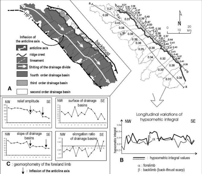
Fig. 7. Morphometry of drainage basins of Chandigarh anticline. (A) Map of Horton’s stream ordering; (B) map of drainage basins and spatial variations of integral hypsometric values; (C) geomorphometric parameters of the anticline ridge (foreland limb).
order) (Fig. 7A). The hypsometric analysis was per-formed to express quantitatively the evolution of the drainage basins (Fig. 7B). The hypsometric analyses, drawn for all of the basins in the study area, are ascribed to two main groups, each marked by a partic-ular shape and range of hypsometric integral (d). In the southwestern part, the first group is characterized by lower values of d (d = 0.33). In contrast, the d varied in northwestern part between 0.39 to 0.50 (d = 0.4). The comparison between different hypsometric curves and integrals are related to the degree of drainage basins maturity and reflect relative age. Investigation on the divide morphology reveals generalized development of headwalls where frontal flank streams have cut the anticline axis. In the southwestern drainage basins, denudational processes on slopes are widespread and more active than downcutting. The landscape is marked by wide V-shaped valleys with concave slope profiles. From a geomorphological standpoint, the northern drainage basins have achieved a stationary equilibrium state (zone I, Fig. 6B and C). In the northeastern drainage basins, downcutting is strongly marked and the landscape is characterized by deep valleys. The steep drainage and high local relief are subjected to short-term uplift. This establishes that the foreland limb is more mature and less active than the backlimb, which is linked to an active backthrust.
The gentle foreland limbs are characterized by a system of parallel streams running perpendicular to the drainage divides and anticline axis. The longitudinal profiles of rivers display concave graded profiles. Sig-nificant changes of slope are rare. As opposed to Janauri ridge, the drainage divide is strongly shifted to the northeast (Fig. 6B). The divide is located several kilometres behind the fold axis and has retreated sig-nificantly into the backlimb of the active anticline. The southwestern forelimb has a marked asymmetric drainage basin (Fig. 7A). This asymmetry is illustrated by the shape of the forelimb stream networks flowing from the hinge anticline to the Indo-Gangetic plain (Fig. 6B). This asymmetry is illustrated by the shape of the stream networks with the major tributaries com-ing from their right margin. In each drainage basin, the asymmetry occurs because the small tributaries perpen-dicular to the main streams erode more vigorously on the northwestern side of valley than on the southeast. Asymmetry factors (AF) generally show a uniform trend and have a similar direction and high values (AF = 70–80). River channels are affected by lateral tilting by progressively migrating downtilt (Fig. 6D). Progressive tilting of the ridge and the consequent channel shift down-dip cause asymmetry of the stream
network. This implies that rivers have migrated uni-formly and largely to the southeast. The stream system must have started from northwest to the southeast, as is still seen today (zone III, Fig. 6B). We attribute these anomalies of the stream system to a propagation of the folding anticline to the southeast.
Relief amplitude and slope of the foreland limb indicate segmentation length. Several bent (sigmoidal) anticlines are linked to two lineaments oriented NE– SW (Fig. 7A). This anticline is post-dates inherited structure of the basements and could be controlled by blind deep transverse faults (Valdiya, 2001).
6. Discussion: morphotectonical evolution of the Quaternary frontal anticlines
Results of investigations into topographic variations and drainage network indicate growing and lateral propagation directions of the Jaunari and Chandigarh frontal anticlines during the Quaternary. The frontal thrust verges to the foreland and backthrusts to the hinterland (Soan and Pinjore duns). In this area, geo-morphic parameters showing the growth of frontal anti-clines have been observed: (1) asymmetry of the drainage indicating the direction of propagation of the segment anticline; (2) radial drainage basins showing push-ups—these culminations are en echelon arranged of overlapping anticlines or restraining bends; (3) allu-vial fan deposits in the hinge anticline indicating cap-ture of palaeothalwegs—these early streams channels, perpendicular to the anticline axis and crossing ridges in antecedent valleys, predate the ridge growth; (4) transverse profiles in the Janauri area suggest that ridges have been segmented by lateral propagation and, then, linked by individual fold-segments (Fig. 8). By using these above geomorphic parameters, we demonstrate that morphological data and drainage net-works in an active frontal zone can reveal fold growth. It is affected by a high spatial variability of folding and a sensitivity of the fluvial system to active tectonic processes, which are outlined by anomalies of streams channels and high asymmetry in drainage basins. Geo-morphometry suggests drainage basins developed in response to uplift and lateral migration of folding. The Janauri ridge develops from the coalescing of independent segments that grew towards each other. Geomorphic evidence suggests that elementary ridges tend to link together creating a larger ridge anticline (Delcaillau, 2001; Tate et al., 2001; Davis et al., in press). The rising of the Janauri anticline indicates a divergent lateral propagation. In contrast, the drainage basin asymmetry of the Chandigarh anticline ridge is
systematic and propagates laterally from NW to SE (Fig. 7). The geomorphic expression of long-term fold-ing indicates that the ridges and HFT have propagated laterally (Fig. 8).
In this study, strong variations in the style of deformation from the NW to SE are noted. Consider-ing geomorphic parameters, such as topography and drainage patterns, the ridge belt has been subdivided
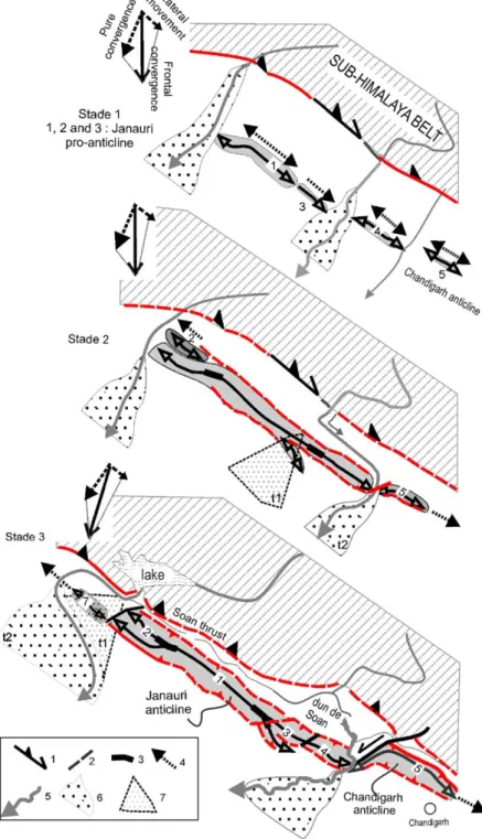
Fig. 8. Kinematics of the Janauri–Chandigarh anticlines: (1) thrusting and lateral deformation movement, (2) blind fault, (3) connection of segments, (4) lateral propagation direction of the deformation, (5) river, (6) active fan body, (7) inactive fan body. Numbers 1, 2, 3, etc. indicate different segments of ridge anticline.
into seven-fold segments (Fig. 2B). Morphotectonic analysis indicates a contrast between the two ridges: the Janauri anticline developed by the connection of four fold segments, while the Chandigarh anticline grew southeastward. Between active anticlines, the fault-related folding is mainly accommodated by the transfer faults of Beas (F1), Staluj (F4) and Ghaggar (F5) (Fig. 2) that absorb differential shortening of fault-propagation folds. Inside anticlines, transverse faults correspond to structural discontinuities that transform motion between segments and accommodate differential displacement within the folded Siwalik series. The basement architecture may have controlled the geometry of ramps in the footwall of the HFT. These faults are expressed by deformed alluvial fan surfaces. From the structural pattern, a kinematic model is proposed with two stages of development: (i) a first stage of fault-propagation fold growth asso-ciated with transfer faults (Fig. 8, stages 1 and 2)— here, the NW–SE trending anticlines have recorded a right step over pattern in the dextral oblique-thrust zone; (ii) a second stage with a present pure shear deformation proved by using GPS data in the Hima-layan Frontal Thrust zone (Banerjee and Bu¨rgmann, 2002) (Fig. 8, stage 3).
References
Banerjee, P., 2002. Crustal shortening and tectonics of the NW Himalaya from GPS measurements.http://www.gisdevelopment. net/proceedings/asiangps/2002/overview/cds002pf.htm. Banerjee, P., Bu¨rgmann, R., 2002. Convergence across the Northwest
Himalaya from GPS measurement. Geophysical Research Letters 29, 13,doi:10.1029/2002GL015184.
Brozovic, N., Burbank, D.W., 2000. Dynamic fluvial systems and gravel propagation in the Himalayan foreland. GSA Bulletin 112 (3), 194 – 412.
Bull, W.B., McFadden, 1977. Tectonic geomorphology north and south of the Garlock Fault, California. Geomorphology 1, 15 – 32. Burbank, D.W., Anderson, R.S., 2000. Tectonic Geomorphology.
Blackwell Scientific, Oxford. 270 pp.
Champel, B., Van der Beek, P., Mugnier, J.L., Leturmy, P., 2002. Growth and lateral propagation of fault-related folds in the Siwa-liks of western Nepal: rates, mechanisms, and geomorphic signa-ture. Journal of Geophysical Research 107 (B6), doi:10.1029/ 2001JB000578.
Cox, R.T., 1994. Analysis of drainage basin symmetry as a rapid technique to identify areas of possible Quaternary tilt-block tec-tonics: an example from the Mississippi embayment. Geological Society of America Bulletin 106, 571 – 581.
Davis, K., Burbank, D.W., Fisher D., Wallace, S., Nobes, D., in press. Thrust-fault growth and segment linkage in the active Ostler fault zone, New Zealand. Journal of Structural Geology.
Delcaillau, B., 1992. Les Siwaliks du Ne´pal oriental. Presses du CNRS. 205 pp.
Delcaillau, B., 2001. Geomorphic response to growing fault-related folds: example from the foothills of central Taiwan. Geodinamica Acta 14, 265 – 287.
Delcaillau, B., 2004. In: Vuibert (Ed.), Reliefs et Tectonique re´cente. 262 pp.
Delcaillau, B., Deffontaines, B., Angelier, J., De´ramond, J., Floissac, L., Souquet, P., Chu, H.T., 1998. Morphotectonic evidence from lateral propagation of an active frontal fold; the Pakuashan anti-cline, foothills of Taiwan. Geomorphology 24, 263 – 290. Elliott, G., 1976. The energy balance and deformation mechanisms of
thrust sheets. Philosophical Transactions of the Royal Society of London 238, 289 – 312.
Farr, T.G., Kobrick, M., 2000. Shuttle Radar Topography Mission produces a wealth of data. Amer. Geophys. Union Eos, vol. 81, pp. 583 – 585.
Gupta, S., 1997. Himalayan drainage patterns and the origin of fluvial megafans in the Ganges foreland basin. Geology 25, 11 – 14. Gupta, S., Ellis, M., 2004. Does the topography of actively growing folds mimic fold structures? The case of the Mohand anticline, frontal Himalaya. Geophysical Research Abstracts 6, 06593. Horton, R.E., 1945. Erosional development of streams and their drainage-basin: hydrophysical and approach to quantitative morphology. Bulletin of the Geological Society of America 56, 275 – 370.
Husson, L., Mugnier, J.L., 2003. Three-dimensional horizon recon-struction from outcrop structural data, restoration, and strain field of the Baisahi anticline, western Nepal. Journal of Structural Geology 25 (1), 79 – 90.
Jackson, J., Leeder, M., 1994. Drainage development of normal faults: an example from Pleasant Valley, Nevada. Journal of Structural Geology 16 (8), 1041 – 1059.
Jackson, J., Van Dissen, R., Berryman, K., 1998. Tilting of active folds and faults in the Manawatu region, New Zealand: evidence from surface drainage patterns, New Zealand. Journal of Geology and Geophysics 41, 377 – 385.
Karunakaran, C., Ranga Rao, A., 1976. Status of exploration for hydrocarbons in the Himalayan region—contributions to stratig-raphy and structure: New Delhi. Himalayan Geology, Seminar, 1 – 72.
Keller, E.A., Pinter, N., 1996. Active Tectonics. Prentice Hall Inc., Englewood Cliffs, New Jersey. 338 pp.
Kumar, S., Wesnousky, S., Rockwell, T.K., Ragnon, D., Thakur, V.C., Seitz, G.G., 2001. Earthquake recurrence and rupture dynamics of Himalayan Frontal Thrust, India. Science 294, 2328 – 2331.
Lave´, J., Avouac, J.P., 2000. Active folding of fluvial terraces across the Siwaliks Hills, Himalaya of central Nepal. Journal of Geo-physical Research 105, 5735 – 5770.
Malik, J.N., Nakata, T., 2002. Active fault and Late Quaternary deformation around Chandigarh and Pinjore Dun, NW Himalaya, India. Abstract in Conference on Quaternary Climate, Tectonics and Environment of Himalaya: Comparison with Other Regions, Nainital India.
Malik, J.N., Nakata, T., Philip, H., Virdi, N.S., 2003. Preliminary observations from a trench near Chandigarh, NW Himalaya and their bearing on active faulting. Current Science 85 (12), 1793 – 1798.
Medwedeff, D.A., 1992. In: Mitra, S., Fisher, G.W. (Eds.), Geometry and Kinematics of an Active, Laterally Propagating Wedge Thrust, Wheeler Ridge, California, Structural Geology of Fold and Thrust Belts, John Hopkins Studies in Earth and Space Sciences, vol. 5, pp. 1 – 28.
Minster, J.B., Jordan, T.H., 1978. Present day plate motions. Geo-physical Research Letters 83, 5331 – 5354.
Molnar, P., Pandey, M.R., 1989. Rupture zones of great earthquakes in the Himalayan region. Proceedings of the Indian Academy of Sciences. Earth and Planetary Sciences 98, 61 – 70.
Mueller, K., Talling, P., 1997. Geomorphic evidence for tears faults accommodating lateral propagation of an active fault-bend fold, Wheeler Ridge, California. Journal of Structural Geology 19 (3–4), 397 – 411.
Nakata, T., 1972. Geomorphic History and Crustal Movement of Foothills of the Himalaya. Institute of Geography, Tohuku Uni-versity, Sendai, p. 77.
Nakata, T., 1989. Active faults of the Himalaya of India and Nepal. In: Malinconico, L.L., Lillie, R.L. (Eds.), Tectonics of the Western Himalayas, Geological Society of America Paper, vol. 232, pp. 243 – 264.
Powers, P.M., Lillie, R.J., Yeats, R.S., 1998. Structure and shortening of the Kangra and Dehra Dun reentrants, Sub-Himalaya, India. GSA Bulletin 110 (8), 1010 – 1027.
Rebeiro-Hargrave, A., 1999. Large scale modelling of drainage evo-lution in tectonically active asymmetric intramontane basins using cellular automata. Zeitschrift fu¨r Geomorphologie. N.F., Supple-mentband 118, 121 – 134.
Salvany, J., 2004. Tilting neotectonics of the Guiadiamar drainage basin, SW Spain. Earth Surface Processes and Landforms 29, 145 – 160.
Schelling, D., Arita, K., 1991. Thrust tectonics, crustal shortening, and the structure of the far-eastern Nepal Himalaya. Tectonics 10 (5), 851 – 862.
Schumm, S.A., 1986. Alluvial river response to active tectonics. In: Studies in National Research Council (Ed.), Active Tectonics. National Academy Press, Studies in Geophysics, Washington, D.C, pp. 80 – 94.
Strahler, A.N., 1952. Hypsometric (area-altitude) analysis of erosional topography. Bulletin of the Geological Society of America 63, 1117 – 1142.
Sung, O., Chen, Y.C., in press. Geomorphic evidence and kinematic model for quaternary transfer faulting of the Pakuashan anticline, central Taiwan. Journal of Asian Earth Sciences.
Suresh, N., Bagati, T.N., Thakur, V.C., Humar, R., Sangode, S.J., 2002. Optically stimulated dating of alluvial fan deposits of Pinjaur Dun, NW Sub Himalaya. Current Science 82 (10), 1267 – 1274.
Tate, A., Mueller, K.J., Golombek, 2001. Geometry and kinematics of wrinkle ridges on lunae and solis plana, Mars: implications for fault/fold growth history. Lunar and Planetary Science XXXIII. Thakur, V.C., 2004. Active tectonics of Himalayan Frontal Thrust and seismic hazard to Ganga plain. Current Science 86 (11), 1554 – 1560.
Valdiya, K.S., 2001. Reactivation of terrane-defining boundary thrusts in central sector of the Himalaya: implications. Current Science 81 (11), 1418 – 1431.
Valdiya, K.S., 2003. Reactivation of Himalayan Frontal Fault: impli-cations. Current Science 85 (7), 1031 – 1040.
Watters, T.R., 1988. Wrinkle ridge assemblages on the terrestrial planets. Journal of Geophysical Research 93, 10236 – 10254. Wiltschko, D.V., Eastman, D., 1983. Role of basement warps and faults in localizing thrust fault ramps. In: Hatcher, R.D., Williams, H., Zeitz, I. (Eds.), Contributions to the Tectonics and Geophysics of Mountain Chains, Geological Society of America Memoir, vol. 158, pp. 177 – 190.
Yeats, R.S., Lillie, R.J., 1991. Contemporary tectonics of the Himalayan Frontal Fault system: folds, blind thrusts and the 1905 Kangra earthquake. Journal of Structural Geology 13 (2), 215 – 225.