HAL Id: insu-00844884
https://hal-insu.archives-ouvertes.fr/insu-00844884
Submitted on 16 Jul 2013
HAL is a multi-disciplinary open access
archive for the deposit and dissemination of
sci-entific research documents, whether they are
pub-lished or not. The documents may come from
teaching and research institutions in France or
abroad, or from public or private research centers.
L’archive ouverte pluridisciplinaire HAL, est
destinée au dépôt et à la diffusion de documents
scientifiques de niveau recherche, publiés ou non,
émanant des établissements d’enseignement et de
recherche français ou étrangers, des laboratoires
publics ou privés.
Manival torrent reconstructed with LiDAR and tree-ring
data
J. Lopez Saez, C. Corona, M. Stoffel, A. Gotteland, F. Berger, F. Liébault
To cite this version:
J. Lopez Saez, C. Corona, M. Stoffel, A. Gotteland, F. Berger, et al.. Debris-flow activity in abandoned
channels of the Manival torrent reconstructed with LiDAR and tree-ring data. Natural Hazards and
Earth System Sciences, European Geosciences Union, 2011, 11 (11), pp.1247- 1257.
�10.5194/nhess-11-1247-2011�. �insu-00844884�
www.nat-hazards-earth-syst-sci.net/11/1247/2011/ doi:10.5194/nhess-11-1247-2011
© Author(s) 2011. CC Attribution 3.0 License.
and Earth
System Sciences
Debris-flow activity in abandoned channels of the Manival torrent
reconstructed with LiDAR and tree-ring data
J. Lopez Saez1, C. Corona1, M. Stoffel2,3, A. Gotteland1, F. Berger1, and F. Li´ebault4
1Cemagref UR EMGR, 2 rues de la papeterie, BP 76, 38402 Saint-Martin d’H`eres Cedex, France
2Laboratory of Dendrogeomorphology, Institute of Geological Sciences, University of Bern, Baltzerstr. 1 + 3,
3012 Bern, Switzerland
3Climatic Change and Climate Impacts, Institute for Environmental Sciences, University of Geneva, 7, chemin de Drize, 1227
Carouge-Geneva, Switzerland
4Cemagref UR ETGR, 2 rues de la papeterie, BP 76, 38402 Saint-Martin d’H`eres Cedex, France
Received: 31 January 2011 – Accepted: 14 March 2011 – Published: 9 May 2011
Abstract. Hydrogeomorphic processes are a major threat
in many parts of the Alps, where they periodically dam-age infrastructure, disrupt transportation corridors or even cause loss of life. Nonetheless, past torrential activity and the analysis of areas affected during particular events remain often imprecise. It was therefore the purpose of this study to reconstruct spatio-temporal patterns of past debris-flow activity in abandoned channels on the forested cone of the Manival torrent (Massif de la Chartreuse, French Prealps). A Light Detecting and Ranging (LiDAR) generated Digi-tal Elevation Model (DEM) was used to identify five aban-doned channels and related depositional forms (lobes, lat-eral levees) in the proximal alluvial fan of the torrent. A to-tal of 156 Scots pine trees (Pinus sylvestris L.) with clear signs of debris flow events was analyzed and growth dis-turbances (GD) assessed, such as callus tissue, the onset of compression wood or abrupt growth suppression. In total, 375 GD were identified in the tree-ring samples, pointing to 13 debris-flow events for the period 1931–2008. While de-bris flows appear to be very common at Manival, they have only rarely propagated outside the main channel over the past 80 years. Furthermore, analysis of the spatial distribution of disturbed trees contributed to the identification of four pat-terns of debris-flow routing and led to the determination of three preferential breakout locations. Finally, the results of this study demonstrate that the temporal distribution of de-bris flows did not exhibit significant variations since the be-ginning of the 20th century.
Correspondence to: J. Lopez Saez (jerome.lopez@cemagref.fr)
1 Introduction
Hydrogeomorphic processes represent one of the most com-mon and widespread of all natural hazards in many moun-tain and hillslope environments worldwide (Jakob, 2005; Shroder et al., 2011). They repeatedly cause severe dam-age and destruction to settlement areas, transportation cor-ridors, and infrastructure or even lead to loss of life, es-pecially on alluvial fans and debris-flow cones. Because of their high flow velocity and poor temporal predictabil-ity, forecasting is rarely possible (Wieczorek and Snyder, 2009) and no rigorous(database) methods are available that would allow determination of event probability, be it based on physically measured characteristics of a catchment or on statistical approaches (Mayer et al., 2010). Therefore, in or-der to avoid damage or fatalities, an appropriate delineation of potentially hazardous areas is needed, demanding knowl-edge about event frequency and magnitude (Jakob and Bovis, 1996; Mayer et al., 2010).
A major obstacle for such analysis is the lack of data with satisfying spatial resolution or precision over medium to long timescales and on a continuing basis (Wieczorek and Snyder, 2009). Usually, the temporal distribution of hydrogeomor-phic processes is estimated at supradecadal timescales and derived from large inventories of historical archives such as local, state government (e.g. administrative, fiscal or mili-tary works), religious (e.g. episcopal or diocesan archives), private or notarial archives (Barriendos et al., 2003). These archives include narrations, paintings, newspaper accounts, terrestrial or aerial photographs, remote sensing series, or incidental statements (Tropeano and Turconi, 2004; Coeur and Lang, 2008). However, difficulties are numerous in ac-cessing, extracting, organizing, databasing, and analyzing
such information because it has not usually been collected
for scientific purposes. Problems may involve
conscien-tiousness of the observer, editing and recording process is-sues, and the haphazard nature of recorded events in both time and space (Ibsen and Brunsden, 1996). Furthermore, archival data is always biased toward catastrophic events and largely undersampled in unpopulated areas (Mayer et al., 2010). Additional anthropocentric bias is introduced when interviewing residents because human memory is short-lived, and highly selective (Barriendos et al., 2003), meaning such records will likely contain more frequent events of the recent past (Mayer et al., 2010).
Therefore, archival records should be supplemented with other techniques (Ibsen and Brunsden, 1996; Jakob, 2005). On forested cones, hydrogeomorphic processes can destroy or damage trees in or adjacent to their flow paths (Stoffel and Bollschweiler, 2008; Bollschweiler and Stoffel, 2010a). Dendrogeomorphology allows a reconstruction of past geo-morphic activity to be inferred from information preserved in tree rings (Alestalo, 1971; Stoffel et al., 2005). In the past, dendrogeomorphic research has largely focused on the reconstruction of debris-flow frequency (e.g. Strunk, 1997; Bollschweiler and Stoffel, 2010b) and magnitude (e.g. Hupp, 1984; Stoffel, 2010). Spatial patterns of previous activity on cones and in channels have also repeatedly been compared with archival records on flooding (e.g. Stoffel et al., 2005; Mayer et al., 2010). In addition, triggering weather con-ditions or changes in the seasonality of debris-flow activity with time (Stoffel et al., 2008, 2011) were evaluated.
With a few exceptions, dendrogeomorphic studies focused on trees growing on cones; in contrast, trees growing inside or next to debris-flow channels have rarely been the subject of research, although they yield valuable data on (i) more recent or (ii) smaller in-channel events (e.g. Arbellay et al., 2010; Szymczak et al., 2010), as well as on (iii) periods of activity in currently abandoned channels (Bollschweiler et al., 2008).
It is therefore the aim of this study to reconstruct spatial patterns of past debris-flow activity inside and next to aban-doned channels on the depositional cone of the Manival tor-rent (Massif de la Chartreuse, French Prealps). We used a Light Detecting and Ranging (LiDAR) generated Digital Ele-vation Model (DEM) to identify abandoned channels and re-lated forms (lobes, lateral levees) in the proximal alluvial fan of the torrent and analyzed growth disturbances in 312 tree-ring series obtained from 156 Scots pine (Pinus sylvestris L.) trees disturbed by past debris flows. The paper (i) reports on the frequency of debris flows affecting abandoned chan-nels, (ii) analyzes breakout locations of past events, and (iii) compares the reconstructed time series with archival data.
2 Study site
The Manival torrent (Is`ere, French Prealps, 45◦17′N,
5◦49′E) is considered one of the largest debris-flow torrents
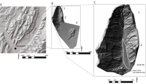
of the Northern French Prealps (Besson, 1996; Fig. 1a). It is located in the Massif de la Chartreuse on the southeast-ern slopes of the Is`ere valley, about 10 km north of
Greno-ble (Fig. 2a). The catchment has a size of 7.3 km2and
ex-tends from Bec Charvet at 1738 m a.s.l. to the confluence with the Is`ere River at 250 m a.s.l.
Debris flows at Manival are commonly triggered from a large amphitheatre located in an anticline and developed in intensely folded and interbedded limestones and marls (mean thickness: 1000 m) of Jurassic age (Gignoux and Moret, 1952). As a result, bedrock is intensely fractured and there-fore highly sensitive to weathering and erosion. The upper basin hillslopes are almost devoid of vegetation and have
mean slope angles varying between 40 and 50◦. Due to
lacking local pluviometric data, precipitation has been ex-trapolated from data of the nearby Saint Martin d’H`eres
sta-tion (45◦10′N, 5◦46′E, 220 m a.s.l.; Mathys, 1988;
Bro-chot, 1991; Gruffaz, 1997). Mean annual precipitation is about 1000 mm in the lower parts of the basin and 1800 mm at its summit (mean: 1250 mm; Veyrat-Charvillon, 2005). Extreme daily precipitations with decadal recurrence are es-timated to 100 mm, with intense rainstorms being most fre-quent in summer. Debris flows at Manival have generally occurred during late spring and summer.
The Manival fan has a size of 4.3 km2, and a mean slope
angle of 8◦. The alluvial fan has a radius of 2 km and
dis-placed the Is`ere River to the northwestern slopes of the main valley. The fan is largely non forested below 460 m a.s.l. and occupied by the villages of Nazaire-les-Eymes, Saint-Ismier, and Bernin (Fig. 1a).
Archival data on debris flows at Manival are available from different sources (Lang et al., 2003). Fifty-six damaging events have been recorded since AD 1673. Recently, Na-tional Agency for Mountain Terrain Restoration (RTM) has listed 25 debris flow since 1900, but the chronology is likely to be rather incomplete (Brochot et al., 2000; Lang et al., 2003). According to the sources listed above, the last debris flow reaching the bottom of the fan occurred in 1953. Ever since, urban development has increased on the fan. Quan-titative data on events is scarce and limited to the recent past; the largest event on record occurred in 1968 and
de-posited ∼60 000 m3of debris on the fan (Veyrat Charvillon,
2005), but RTM only estimated the volume of five debris-flow events in 1968, 1984, 1991, 1998, and 2008.
Between 600 and 850 m a.s.l., the Manival torrent has formed a 300-m wide and incised valley with a mean slope
angle of 11◦ (Fig. 2b, c). This reach of the Manival
tor-rent has received considerable attention by RTM since the late 19th century (Veyrat-Charvillon and Memier, 2006): in 1926, two 150 and 230-m long dykes were built on both sides of the active channel (Fig. 2c), leading to an open central
Fig. 1. (A) Overview of the Manival catchment as seen from the upper basin with (1) the study site, (2) debris-flow cone, and (3) the
village of Saint-Ismier; (B) View of an abandoned channel with characteristic lateral levees covered with (C, D) trees affected by past debris-flow activity.
deposition zone. In addition, several check dams have been constructed to control channel scour. Since 1992, a large
check dam and a 25 000-m3sediment trap prevent debris to
move below 550 m a.s.l. The active channel is located inside the dykes and up to 10 m below the cone surface covered with an open P. sylvestris forest.
3 Material and methods 3.1 Geomorphic mapping
Fieldwork started with the mapping (scale: 1/1000) of fea-tures associated with past debris-flow activity such as aban-doned flow paths and channels, as well as levees and lobes, using airborne LiDAR data. LiDAR data acquisition was performed in spring 2009 by Sintegra (Meylan, France) us-ing a Riegl© LMS-Q560 laser scanner. Flight height was
∼2000 m, resulting in a footprint size of ∼0.25 m. The point
density was 5 points m−2. An Ordinary Kriging
interpola-tion was performed with ArcMAP 9.3 (ESRI Corp.) and a DEM with a 1-m resolution was derived from the LiDAR
data. Using the Spatial Analysis Toolbox, two hillshade
maps (Fig. 2c) were created from the DEM with a sun
eleva-tion angle of 30◦and an azimuth angle of 45 and 315◦. These
hillshade maps, combined with aerial orthophotos, were used to digitize abandoned channels and geomorphic forms asso-ciated with past debris-flow activity. All the features of the LiDAR-derived geomorphic map were then validated during a field survey.
3.2 Sampling strategy
Based on the geomorphic map and an outer inspection of the stem surface, 312 increment cores were sampled from 156 P. sylvestris trees. Two cores were sampled from each
Fig. 2. (A) The Manival torrent is located on the southeastern slopes of the Massif de la Chartreuse, 10 km northeast of Grenoble. (B) It is
composed of three characteristic parts: (1) the upper basin, (2) a large valley with an active flow channel and several abandoned channels, and (3) the debris-flow cone. (C) Detail of the study site.
tree in the flow direction. GPS coordinates with <1 m ac-curacy were recorded for each tree sample using a Trim-ble GeoExplorer. Sampling height was chosen according to the morphology of the stem: injured or tilted trees were sampled at the height of the disturbance; cores from buried and/or decapitated trees were extracted next to the stem base so as to preserve as much tree-ring information as possi-ble (Bollschweiler et al., 2008); cores from trees showing no visible GD were extracted at an average height of ∼130 cm. In addition to the trees sampled inside the channels, fifteen undisturbed P. sylvestris trees showing no signs of geomor-phic impacts were selected on the cone and used to build a reference chronology. Two cores were extracted per tree, perpendicularly to the slope, at breast height.
3.3 Tree-ring analysis
In the laboratory, tree samples were analyzed and data pro-cessed following the standard procedures described in Stof-fel and Bollschweiler (2009). Single steps of surface anal-ysis included sample mounting on a slotted mount, sample drying, and surface preparation by finely sanding the up-per core surface up to grit size 600. In the laboratory, tree rings were counted and ring widths measured to the nearest 0.01 mm using a digital LINTAB positioning table connected to a Leica stereomicroscope and TSAPWin Scientific soft-ware (Rinntech, 2011).
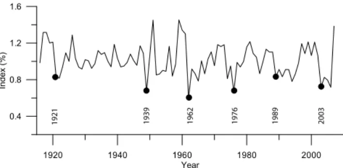
The reference chronology (Fig. 4) was developed based on the growth curves of the undisturbed trees using ARSTAN software (Cook, 1985). The two measurements of each ref-erence tree were averaged, indexed and detrended using a double detrending procedure (Holmes, 1994) with the pur-pose to enhance the climate signal in ring width series. First,
a negative exponential curve (or linear regression) was fitted to the ring series. In a second step we used a cubic smooth-ing spline function with a frequency-response cut-off set at two-thirds of the length of each series (Cook and Kairiuk-stis, 1990). This process created stationary time series for each tree with a mean of 1 and an homogeneous variance. It resulted in a unitless index of radial tree growth. In this way, most of the variability in each ring series assumed to be unrelated to climate such as tree aging and forest stand development was removed.
Increment curves of the disturbed samples were then cross-dated with the reference chronology. The quality of the cross-dating was evaluated using COFECHA (Holmes, 1983) as well as the graphical functions of TSAPWin (Rin-ntech, 2011). The purpose of this procedure was (i) to correct faulty tree-ring series derived from disturbed samples (e.g. false or missing rings) and (ii) to separate climatically driven fluctuations in tree growth from growth disturbances caused by debris-flow activity. As no significant correlation was found between the reference chronology and 6 cores from affected trees (3.8%), these cores were not considered for further analysis.
3.4 Sign of disturbance in the tree-ring record
Depending on their volume, velocity or energy, debris flows can injure trees by (i)tilting, (ii) breaking or (iii) scarring stems (Fig. 1c, d). Cross-dated growth curves were used to determine the initiation of GD. A reduction in annual ring width over several years was interpreted as damage to the root system, loss of a major limb, or a partial burial of the trunk resulting from debris-flow activity (Stoffel and Bollschweiler, 2008). In this study, growth-ring series had
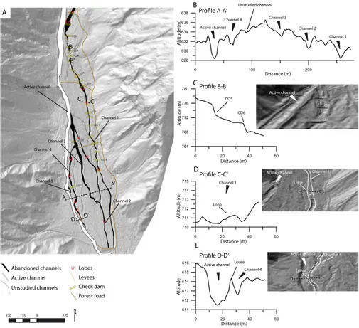
710 711 712 713 714 715 0 100 200 628 630 632 634 636 638 0 20 40 60 611 612 613 614 615 616 Active channel Channel 4 Channel 3 Channel 2 Channel 1 Channel 1 Lobe Active channel Channel 4 Levee Channel 1 Channel 4 Channel 3 Channel 5 Active channel Profile A-A’ A’ A Profile C-C’ C Profile D-D’ D D’ CD3 CD5 CD6 CD8 CD10 CD18 CD20 CD21 Abandoned channels Active channel Check dam 0 20 40 60 764 768 772 776 780 Profile B-B’ 0 20 40 60 B B’ Active channel CD5 CD6 CD7 CD5 CD6 B B’
Active channel Channel 1 Lobe
Active channel Channel 4 Levee D D’ C C’ 270 135 0 270 N A B C D E Unstudied channels Unstudied channel Lobes Levees Channel 2 CD12 CD14 C’ CD1 Forest road A ltitude A ltitude (m) A ltitude (m) A ltitude (m) Distance (m) Distance (m) Distance (m) Distance (m)
Fig. 3. (A). Abandoned channels identified on the hillshade map computed using the DEM derived from airborne LiDAR data. (B, C, D, E) Profiles of the Manival torrent at four characteristics location. (A) Cross sections of the five studied abandoned channels. (B) The check
dams constructed in the 1950s and 1960s. (C) Section of a depositional lobe. (D) Section of the active channel.
to exhibit (i) a marked reduction in annual ring width for at least three consecutive years, such that the (ii) width of the first narrow ring was 50% or less of the width of the annual ring of the previous year.
In the case of tilted stems, both the appearance of the cells and growth curve data were analyzed (e.g., Braam et al., 1987). The onset of compression wood is interpreted as a response to stem tilting induced by a unilateral debris-flow pressure (Fantucci and Sorriso-Valvo, 1999). At the level of tree rings, the tilting of conifer trunks will result in asym-metric tree-ring growth, i.e. in the formation of wide annual rings with smaller, reddish-yellow colored cells with thicker cell walls (so-called compression wood; Timell, 1986) on the tilted side and narrow (or even discontinuous) annual rings on the opposite side of the tree (Panshin and de Zeeuw, 1970; Carrara and O’Neill, 2003).
Finally, cores were visually inspected so as to identify further signs of past debris-flow activity. The formation of callus tissue was interpreted as a reaction to the corrasion of tree stems by the flow that causes cambium damage and scars (Hupp, 1984).
3.5 Reconstructing frequency and assessing spatial patterns of past events
After the dating of GD on the samples, the position of all trees with GD in the same year was marked on the geomor-phic map. This representation of trees affected during indi-vidual events allowed the identification and interpretation of spatial patterns of past events in currently abandoned chan-nels. We required that a minimum of five trees exhibits a response for an event to be dated. Preferential breakout lo-cations, as well as the travel distance of the reconstructed debris-flow events, were assessed by the distribution of dis-turbed trees in a specific event year.
4 Results
4.1 Geomorphic map
Geomorphic mapping allowed identification of features re-lated to past debris-flow activity on the depositional cone of the Manival torrent. The features and deposits invento-ried in the study area covering approximately 15 ha are illus-trated in Fig. 3a and include five well-developed abandoned
1920 1940 1960 1980 2000 Year 0.4 0.8 1.2 1.6 In d e x ( % ) 2003 1989 1976 1962 1939 1921
Fig. 4. Tree-ring chronology of Pinus sylvestris L. for the Manival
torrent dating back to 1918. Individual series are detrended with (i) a negative exponential curve or a linear regression and (ii) by a cubic smoothing spline function.
channels (Fig. 3b, c, d, e). The tracks of these abandoned channels are still clearly visible on the LiDAR derived hill-shade maps, although their banks have partially collapsed since the last debris-flow activity and their beds are now re-covered by fallen debris and vegetation (Fig. 1b). The length of channels varies from 60 (channel 5) to 1300 m (channel 1) with depths of 1 to 3 m and widths comprised between 5 and 20 m (Fig. 3b, c, d, e). All channels are bordered with char-acteristic depositional lobes and lateral levees (Fig. 3d, e).
4.2 Age structure of the stand and growth disturbances
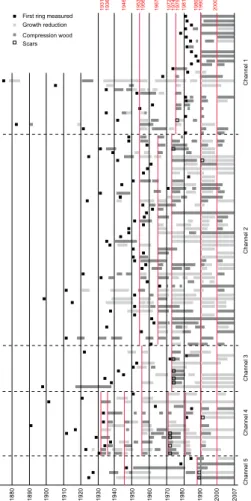
A total of 156 trees was cored at Manival, 36 (23%) in channel 1, 79 (51%) in channel 2, 13 (8%) in channel 3, 21 (14%) in channel 4, and 7 (4%) in channel 5. Visual cross-dating was carried out by means of the skeleton plot method and primarily based on the narrow rings of 1921, 1939, 1962, 1976, 1989, and 2003 (Fig. 4). The average age at sampling height was 62 ± 27 yr. While the oldest tree selected for analysis attained sampling height in AD 1875, the youngest sample only reached breast height in 1989. The spatial distribution of tree ages within the stand is het-erogeneous (Fig. 5), with older trees mainly being located in the upper part of channel 4 (average age = 95 ± 14 yr) and youngest trees growing in the lower parts of channel 1 (average age = 29 ± 6 yr). The stand appears relatively ho-mogeneous (average age = 60 ± 11 yr) in the lower part of channel 2.
Amongst the sampled trees, 15 (9%) showed at least one visible scar, 41 (27%) were tilted, and 100 (64%) exhibited no external defects. The 312 samples permitted identification of 375 GD in the form of compression wood after tilting (196 cases, 53%), callus tissue (15; 4%), and abrupt growth re-leases or growth suppressions (164, 43%; Fig. 6). The oldest GD in the tree-ring series was dated to 1878 and GD became more frequent after 1930. In total, GD allowed reconstruc-tion of 13 debris-flow events between 1931 and 2008: 1931, 1936, 1946, 1953 1956, 1967, 1972, 1974, 1975, 1981, 1989,
Abandoned channels Active channel
Tree age in years (reference 2008) < 40 41 - 60 61 - 80 81 - 100 101 - 120 121 - 135 225 112,5 0 225 N
Fig. 5. Age structure of the forest stand at the study site.
1990, 2000 (Fig. 6). The years 1974 (24%), 1990 (40%), and 2000 (24%) are those exhibiting the largest number of trees responding to debris-flow disturbance.
4.3 Spatial distribution of trees affected by debris flow
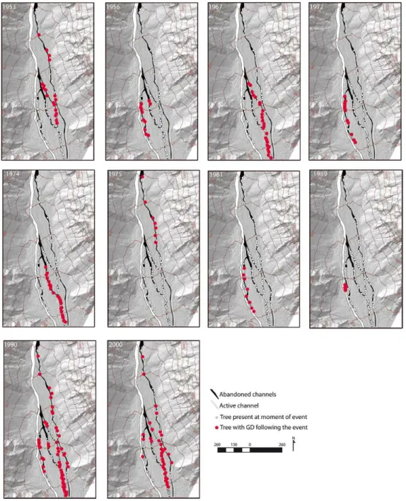
Maps illustrating the spatial distribution of characteristic Manival debris flows are provided in Fig. 7; they point to the presence of four patterns of debris-flow routing with re-spect to the overflowing point. In flow pattern A, illustrated with a debris flow dated to 1975 (Fig. 7), surges leave the currently active Manival channel at the uppermost difflu-ence at 820 m a.s.l. The 1975 debris flow disturbed all trees in and next to channel 1 and was stopped at ∼690 m a.s.l. when it reached check-dam CD14. The debris flows of 1967, 1972, 1974, and 1981 can be summarized with flow pattern B. Here, events apparently avulsed between the active chan-nel and chanchan-nels 2, 3, and 4 at ∼700 m a.s.l.; and flowed through channels 2 in 1967, 3 in 1974, and 4 in 1972 and 1981. The different flows converged again with the active channel at ∼600 m a.s.l. in 1972 and 1981 to reach the check dam at 550 m a.s.l. Flow pattern C is illustrated with the de-bris flow of 1989, when a spatially limited overflow event left the active channel at ∼640 m a.s.l. to disturb a limited number of trees located in channel 5. Finally, flow pattern D is represented by debris flows in 1953, 1956, 1990, and 2000. This type of event shows two sets of possible break-out locations at 820 and 700 m a.s.l. (1953, 1990, 2000) and
1 8 8 0 1 8 9 0 1 9 0 0 1 9 1 0 1 9 2 0 1 9 3 0 1 9 4 0 1 9 5 0 1 9 6 0 1 9 7 0 1 9 8 0 1 9 9 0 2 0 0 0 2 0 0 7 C h a n n e l 1 C h a n n e l 2 C h a n n e l 3 C h a n n e l 4 C h a n n e l 5 1 95 3 1 95 6 1 96 7 1 97 2 1 97 4 1 97 5 1 98 1 1 98 9 1 99 0 2 00 0
First ring measured Growth reduction Compression wood Scars 1 94 6 1 93 1 1 93 6
Fig. 6. Skeleton plot showing event responses from tree sam-ples collected in or next to the five abandoned channels of the Manival torrent.
at 700 and 680 m a.s.l (1956), respectively. The 1953 de-bris flow preferentially affected trees located in channels 1 and 2 and was deposited halfway down the channel, at the confluence between channels 2 and 3 (620 m a.s.l.). In 1956, surges traveled the entire length of channel 4 and stopped at
∼620 m a.s.l., mainly causing damage to trees located in the
upper part of channel. The massive debris flows of 1990 and 2000 left damages to vegetation in all channels.
5 Discussion
In this study, a coupling of detailed geomorphic mapping with dendrogeomorphic analysis has been used to reconstruct the frequency and spatial extent of debris-flow events in the Manival torrent over the last 80 years. Analysis yielded ex-tensive data on 13 events between 1931 and 2008 and al-lowed reconstruction of past debris-flow activity in five
chan-nels that are currently abandoned. In addition, the large
amount of tree-ring data combined with the results from the geomorphic mapping enabled distinction of four different
patterns of spatial activity of former debris flows and iden-tification of preferential breakout locations of debris-flow surges.
The dendrogeomorphic reconstruction of debris-flow ac-tivity at Manival was limited by the relatively young age of trees. Although trees with more than 130 increment rings were identified, the average age of P. sylvestris was only 62 yr at the study site. In the lower part of channel 1, most trees were even younger and averaged only 29 yr. Further-more, we need to stress that this study exclusively focused on debris-flows that actually left the active channel and reac-tivated abandoned channels on the cone surface. The more frequent but smaller debris flows, such as those registered in February 1963 or July 1993 (Veyrat-Charvillon, 2005), do not appear in our reconstruction, as they were contained within the active channel and did not cause any damage to the vegetation growing on the cone. Conversely, it is also known that debris flows may partly or entirely eliminate for-est stands (Arbellay et al., 2010), thus masking witnesses of former events. Finally, we need to bear in mind that we ex-clusively sampled trees along or within abandoned channels and thus may have overlooked older events in areas where signs of former channel processes may have been masked by more recent deposits (Sorg et al., 2010). As a result of the above considerations, the number of reconstructed events has to be seen as a minimum frequency, despite the fact that most (if not all) breakout events with channel reactivation have been captured since the 1930s as a result of the large replication of trees showing GD in individual years.
In this study, the onset of compression wood after tilt-ing and abrupt changes in growth (releases or suppression) were by far the wound type most frequently observed (53% and 43%, respectively); injuries caused by the abrasive ac-tion of debris-flow sediment were, in contrast, rare and only accounted for 4% of all reconstructed GD. This scarcity of injuries as compared to other signs of past activity may re-flect the sampling strategy. In this study, increment cores were used rather than cross-sections, since the forest at Mani-val has a protective function and trees could not therefore be felled for analysis. As a result of the thick and rough bark of P. sylvestris, external signs of injuries are very efficiently and rapidly blurred on the stem surface, as it grows abundantly and sporadically scales off its outermost bark layers (Stof-fel and Perret, 2006). Furthermore, P . sylvestris abundantly produces vertical resin ducts in its phloem and xylem, but does not, at the same time, produce tangential rows of trau-matic resin ducts (TRD) as a reaction to mechanical wound-ing (Stoffel, 2008). As a result, in contrast to other conifer species, TRD cannot be used to indirectly date overgrown abrasion scars.
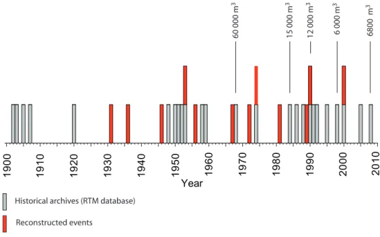
On a temporal scale, our reconstruction considerably complemented archival records of debris-flows at Mani-val (Fig. 8). Only four of the 13 events reconstructed in this study were previously known from archival records, namely the debris flows of 1953, 1975, 1990, and 2000.
Fig. 7. Location of trees showing growth disturbances (GD) during reconstructed debris-flow events. Maps show all living trees as well as
those trees showing an event-response to debris-flow activity in a particular year.
More importantly, the events reconstructed in 1931, 1936, and 1946 filled a considerable gap in historical archives be-tween 1920 and 1948, which was probably related to insuffi-cient monitoring by the RTM (Brochot et al., 2000). In com-bination with the tree-ring record, the database of historic Manival debris flows now contains a total of 33 events span-ning more than 100 yr. Although we are able to identify three periods with increased debris-flow activity in the record (i.e. 1900s, 1950s, and 1990s), we do not consider our database long and complete enough to postulate for an unequivocal
evidence of changes and trends in debris-flow frequency dur-ing the 20th century as a result of climate change, as put for-ward by other studies which were based on much larger and longer time series (e.g. Stoffel and Beniston, 2006; Jomelli et al., 2009).
On a spatial scale, this study has contributed to the doc-umentation and understanding of avulsion events, the lo-calization of the most active breakout locations and to the spread and reach of debris flows on the cone of the Manival torrent. Interestingly, the four events known from archives
60 000 m 3 15 000 m 3 12 000 m 3 6 000 m 3 6800 m 3
Historical archives (RTM database) Reconstructed events 1 9 0 0 1 9 5 0 2 0 0 0 Year 2 0 1 0 1 9 9 0 1 9 8 0 1 9 7 0 1 9 6 0 1 9 4 0 1 9 3 0 1 9 2 0 1 9 1 0
Fig. 8. Comparison of debris-flow frequency as documented from historical archives and with the reconstructed time series obtained with
dendrogeomorphic methods at Manival.
and confirmed with dendrogeomorphology (i.e. 1953, 1975, 1990, and 2000) all correspond to flow patterns A and D. They disturbed trees located in or next to channel 1 after hav-ing left the current main channel at ∼820 m a.s.l. The good concordance between these events and the databases prob-ably reflects the more accurate monitoring of this sector of the cone by the RTM, as channel 1 – also called “Le Petit Manival” (little Manival) – directly threatens the village of Bernin, with destructive events being reported at the turn of the 19th and 20th centuries (1889, 1894, 1902, 1903, 1905, 1907, 1920).
Reconstructed events with outbreaks from the main debris-flow channel were compared with volumes of events
es-timated by RTM (Fig. 8). The known debris flow of
1990 (12 000 m3) was confirmed by tree-ring analysis, as it
overflowed the main channel at 820 m a.s.l. and disturbed trees located in all abandoned channels (Fig. 7). Conversely, it was not possible to reconstruct the events that occurred in 1968, 1984, 1998, and 2008 with
dendrogeomorphol-ogy. In 1968, the debris-flow surge noted in the RTM
database (60 000 m3) stopped at ∼850 m a.s.l. upstream from
the study site. Based on personal observations, the event of
2008 (6800 m3) was restricted to the active channel.
Sim-ilarly, we hypothesize that the events of 1984 (15 000 m3)
and 1998 (6000 m3) did not overflow the active to affect
the abandoned channels. A definition of volume threshold above which debris flows will reactivate channels on the cone is therefore not possible based on the data available. Even more, it seems very likely that the maximum capac-ity of the main channel varies with time and – depending on channel geometry – the flood management strategies and
the flow dynamics and characteristics of events in those ar-eas where avulsion and reactivation of abandoned channels are possible.
6 Conclusions
In this study, the use of aerial LiDAR data permitted geomor-phic mapping of five well-developed abandoned channels of the Manival torrent. Tree-ring analysis coupled with geomor-phic mapping allowed reconstruction of 13 events covering the last 80 years. On a temporal scale, the dendrogeomor-phic study of abandoned channels has proved to be a power-ful tool in substantially adding to the historic record centered on the active channel. The composite chronology revealed that the frequency of debris-flow events had not been
sig-nificantly modified since the beginning of the 20t h century
as previously suggested by (incomplete) historical archives. Although the relatively young age of sampled trees limited the reconstruction, the P. sylvestris trees selected for anal-ysis provided very detailed insights into recent debris-flow activity and routing at the study site. Analysis of the spa-tial distribution of disturbed trees contributed to the identifi-cation of four patterns of debris-flow routing in abandoned channels. Three preferential breakout locations of events could be determined and the travel distance of debris-flow surges assessed. Finally, despite the accurate monitoring of the Manival torrent, our study demonstrates the reliability of dendrogeomorphic approaches to substantially complement historical archives.
Acknowledgements. This research has been supported by the
PARAmount project, “ImProved Accessibility, Reliability and security of Alpine transport infrastructure related to mountainous hazards in a changing climate”, funded by the Alpine Space Programme, European Territorial Cooperation, 2007–2013. It has also been supported by the DENDROGLISS program, funded by the MAIF foundation and by the EU-FP7 project ACQWA (project no. GOCE-20290) and PGRN project. The authors wish to thank ONF-RTM38 colleagues for sampling permission, archival data, and field access.
Edited by: R. Lasaponara
Reviewed by: A. Bartosik and another anonymous referee
References
Alestalo, J.: Dendrochronological interpretation of geomorphic processes, Fennia, 105, 1–140, 1971.
Arbellay, E., Stoffel, M., and Bollschweiler, M.: Dendrogeomor-phic reconstruction of past debris-flow activity using injured broad-leaved trees, Earth Surf. Proc. Land, 35, 399–406, 2010. Barriendos, M., Coeur, D., Lang, M., Llasat, M. C., Naulet, R.,
Lemaitre, F., and Barrera, A.: Stationarity analysis of histori-cal flood series in France and Spain (14th-20th centuries), Nat. Hazards Earth Syst. Sci., 3, 583–592, doi:10.5194/nhess-3-583-2003, 2003.
Besson, L.: Les risques naturels en Montagne, Editions Artes-Pubialp, Grenoble, 438 pp., 1996.
Bollschweiler, M. and Stoffel, M.: Tree rings and debris flows – trends and challenges, Prog. Phys. Geog., 34, 625–645, 2010a. Bollschweiler, M. and Stoffel, M.: Variations in debris-flow
occur-rence in an Alpine catchment – A reconstruction based on tree rings, Global Planet. Change, 73, 186–192, 2010b.
Bollschweiler, M., Stoffel, M., and Schneuwly, M.: Dynamics in debris-flow activity on a forested cone – a case study using dif-ferent dendroecological approaches, Catena, 72, 67–78, 2008. Braam, R. R., Weiss, E. E. J., and Burrough, P. A.: Spatial and
temporal analysis of mass movement using dendrochronology, Catena, 6, 573–584, 1987a.
Brochot, S.: Torrrent du Manival, Etude pr´ealable `a l’am´enagement (rapport), Cemagref/RTM/SITSE, Grenoble, 26 pp., 1991.
Brochot, S., Coeur D., Lang, M., and Naulet, R. : Historisque-Is`ere et torrents affluents. Utilisation de l’information historique pour une meilleure d´efinition du risqu´e d’inondation, Cema-gref/Achtys, Lyon, Grenoble, 2000.
Carrara, P. E. and O’Neill, J. M.: Tree-ring dated landslide move-ments and their relationship to seismic events in southwestern Montana, Quaternary Res., 59, 25–35, 2003.
Cœur, D. and Lang, M.: Use of documentary sources on past flood events for flood risk management and land planning, Compte Rendus Geosciences, 340, 644–650, 2008.
Cook, E. R.: A time series analysis approach to tree-ring standard-ization, PhD Dissertation, University of Arizona, Tucson, AZ, USA, 1985.
Cook, E. R. and Kairiukstis, L. A.: Methods of dendrochronology – applications in the environmental sciences, Kluwer, London, UK, 1990.
Fantucci, R. and Sorriso-Valvo, M.: Dendrogeomorphological anal-ysis of a slope near lago, Calabria (Italy), Geomorphology, 30, 165–174, 1999.
Gignoux, M. and Moret, L.: G´eologie Dauphinoise, Masson, Paris, 391 pp., 1952.
Gruffaz, F.: Torrent du Manival, Is`ere, Etude de bassin et de la plage de depots torrentiels. Rapport RTM / ONF, Grenoble, 66 pp., 1997.
Holmes, R.: Dendrochronology Program Library User’s Manual, Laboratory of Tree-Ring Research University of Arizona, Tuc-son, 1994.
Holmes, R.: Computer-assisted quality control in tree-ring dating and measurement, Tree-ring Bulletin, 44, 69–75, 1983. Hupp, C. R.: Geo-botanical evidence of late Quaternary mass
wast-ing in block field areas of Virginia, Earth Surf. Proc. Land, 8, 439–450, 1983, 1984.
Ibsen, M. L. and Brunsden, D.: The nature, use and problems of historical archives for the temporal occurrence of landslides, with specific reference to the south coast of Britain, Ventnor, Isle of Wight, Geomorphology, 15, 241–258, 1996.
Jakob, M.: Debris flow hazard analysis, in: Debris flow hazards and related phenomena, edited by: Jakob, M. and Hungr, O., Praxis Publishing, Chichester, UK, 411–438, 2005.
Jakob, M. and Bovis, M. J.: Morphometrical and geotechnical con-trols of debris flow activity, southern Coast Mountains, British Columbia, Canada, Z. Geomorphol. Supp., 104, 13–26, 1996. Jomelli, V., Brunstein, D., D´equ´e, M., Vrac, M., and Grancher, D.:
Impacts of future climatic change (2000–2100) on the occurrence of debris flows: A case study in the Massif des Ecrins (French Alps), Climatic Change, 97, 171–191, 2009.
Lang, M., Coeur D., Brochot S., and Naulet R.: Information his-torique et ing´enierie des risques naturel, L’Is`ere et le torrent du Manival, Cemagref editions, 182 pp., 2003.
Mathys, N.: Les torrents du Saint-Eynard. Rapport Cemagref, Grenoble, France, 1988.
Mayer, B., Stoffel, M., Bollschweiler, M., H¨ubl, J., and Rudolf-Miklau, F.: Frequency and spread of debris floods on fans: a dendrogeomorphic case study from a dolomite catchment in the Austrian Alps, Geomorphology, 118, 199–206, 2010.
Panshin, A. J. and de Zeeuw, C.: Textbook of Wood Technology, 1, 3rd edn., 705 pp., McGraw-Hill, New York, USA, 1970. Rinntech: http://www.rinntech.com/content/blogcategory/2/28/
lang,english/, last access: 1 July 2009, 2011.
Shroder, J., Marston, R. A., and Stoffel, M.: Treatise on Geomor-phology, Vol.7, Elsevier B. V, Amsterdam, Ther Netherlands, 460 pp., 2012.
Sorg, A., Bugmann, H., Bollschweiler, M., and Stoffel M.: Debrisflow activity along a torrent in the Swiss Alps: Minimum frequency of events and implications for forest dynamics, Dendrochronologia, 28, 215–223, 2010, doi:10.1016/j.dendro.2009.11.002, 2010.
Strunk, H.: Dating of geomorphological processes using dendroge-omorphological methods, Catena, 31(1–2), 137–151, 1997. Stoffel, M.: Magnitude-frequency relationships of debris flows – a
case study based on field surveys and tree ring records, Geomor-phology, 116, 67–76, 2010.
Stoffel, M.: Dating past geomorphic processes with tangential rows of traumatic resin ducts, Dendrochronologia, 26, 53–60, 2008. Stoffel, M. and Beniston, M.: On the incidence of debris flows from
the early Little Ice Age to a future greenhouse climate: a case study from the Swiss Alps, Geophys. Res. Lett., 33, L16404, doi:10.1029/2006GL026805, 2006.
Stoffel, M. and Bollschweiler, M.: Tree-ring analysis in natural haz-ards research - an overview, Nat. Hazhaz-ards Earth Syst. Sci., 8, 187–202, doi:10.5194/nhess-8-187-2008, 2008.
Stoffel, M. and Bollschweiler, M.: Tree-ring reconstruction of past debris flows based on a small number of samples – possibilities and limitations, Landslides, 6, 225–230, 2009.
Stoffel, M. and Perret, S.: Reconstructing past rockfall activ-ity with tree rings: some methodological considerations, Den-drochronologia, 24(1), 1–15, 2006.
Stoffel, M., Li`evre, I., Conus, D., Grichting, M., Raetzo, H., Gart-ner, H. W., and Monbaron, M.: 400 years of debris flow activity and triggering weather conditions: Ritigraben, Valais, Switzer-land, Arct. Antarct. Alp. Res., 37(3), 387–395, 2005.
Stoffel, M., Bollschweiler, M., Leutwiler, A., and Aeby, P.: Tree-ring reconstruction of debris-flow events leading to overbank sedimentation on the Illgraben cone (Valais Alps, Switzerland), The Open Geology Journal, 2, 36–47, 2008.
Stoffel, M., Bollschweiler, M., Butler D. R., and Luckman B. H.: Tree rings and natural hazards: A state-of-the art, Springer, Dor-drecht, Berlin, London, UK, New York, USA, 505 pp., 2010. Stoffel, M., Bollschweiler M., and Beniston M.: Rainfall
charac-teristics for periglacial debris flows in the Swiss Alps: past inci-dences – potential future evolutions, Climatic Change, 105, 263– 280, 2011.
Szymczak, S., Bollschweiler, M., Stoffel, M., and Dikau, R.: Debris-flow activity and snow avalanches in a steep watershed of the Valais Alps (Switzerland): dendrogeomorphic event re-construction and identification of triggers, Geomorphology, 116, 107–114, 2010.
Timell, T. E.: Compression wood in gymnosperms, 2150 pp., Springer, Berlin, Germany, 1986.
Tropeano, D. and Turconi, L.: Using historical documents for land-slide, debris flow and stream flood prevention, Applications in Northern Italy, Nat. Hazards, 31, 669–673, 2004.
Veyrat-Charvillon, S.: Elaboration d’une m´ethode de pr´ediction du volume maximal d’une lave torrentielle (PREVENT), G´eomorphologie torrentielle, Topographie de terrain et St´er´eophotogramm´etrie sur photographies a´eriennes d’archives. Torrents du Manival, du Merdarˆet et des Arches (Alpes-du-Nord, Is`ere, France), Th`ese de Doctorat (PhD), Universit´e Blaise Pascal, Clermont-Ferrand, 354 pp., 2005.
Veyrat-Charvillon, S. and Memier, M.: Stereophotogrammetry of archive data and topographic approaches to debris-flow torrent measurements: calculation of channelsediment states and a par-tial sediment budget for Manival torrent (Is`ere, France), Earth Surf. Proc. Land, 31, 201–219, 2006.
Wieczorek, G. F. and Snyder, J. B.: Monitoring slope movements, in Young R., and Norby L., Geological monitoring: Boulder, Col-orado, Geol. Soc. Am. Bull., 245–271, 2009.