HAL Id: tel-02392125
https://tel.archives-ouvertes.fr/tel-02392125
Submitted on 3 Dec 2019HAL is a multi-disciplinary open access archive for the deposit and dissemination of sci-entific research documents, whether they are pub-lished or not. The documents may come from teaching and research institutions in France or abroad, or from public or private research centers.
L’archive ouverte pluridisciplinaire HAL, est destinée au dépôt et à la diffusion de documents scientifiques de niveau recherche, publiés ou non, émanant des établissements d’enseignement et de recherche français ou étrangers, des laboratoires publics ou privés.
Ecological impacts of groundwater discharge to
Mediterranean coastal lagoons
Aladin Andrisoa
To cite this version:
Aladin Andrisoa. Ecological impacts of groundwater discharge to Mediterranean coastal lagoons. Biodiversity and Ecology. Aix-Marseille Université, 2019. English. �tel-02392125�
AIX-MARSEILLE UNIVERSITÉ
Ecole Doctorale des Sciences de l’Environnement (ED251) Centre Européen de Recherche et d’Enseignement des Géosciences de l’Environnement (CEREGE)Thesis presented for the degree of: Docteur d’Aix-Marseille Université
Ecological impacts of groundwater discharge
to Mediterranean coastal lagoons
Aladin ANDRISOA
Supervisors: Thomas STIEGLITZ and Patrick RAIMBAULTDate of defense: 26 March 2019
JURY
Luc LAMBS EcoLab, Université Toulouse III Rapporteur Rutger DE WIT MARBEC Montpellier Rapporteur Jaye CABLE University of North Carolina Examinateur Pieter VAN BEEK LEGOS, Toulouse Examinateur Paul TRÉGUER Université de Bretagne Occidentale Examinateur Bruno HAMELIN CEREGE, Aix-Marseille Université Examinateur Franck LARTAUD Sorbonne Université, LECOB, Banyuls-sur-Mer Invité Thomas STIEGLITZ CEREGE, Aix-en-Provence Directeur Patrick RAIMBAULT Institut Méditerranéen d’Océanologie, Marseille Co-Directeur
ABSTRACT
Whilst the role of groundwater discharge and porewater fluxes (recirculation) as important pathways for nutrient delivery to coastal systems is increasingly being recognized, there remains limited evidence of its “downstream” ecological implications. This thesis aims at investigating the ecological role that groundwater flows play in some aspects of the functioning and vulnerability of coastal lagoonal ecosystems. Two contrasting lagoons on the French Mediterranean coastline were studied (La Palme and Salses-Leucate lagoons). Firstly, using concurrent water and radon mass balances, a comparison between the main nutrient sources for La Palme lagoon (karstic groundwater, recirculation, diffusion from sediments, inputs from a sewage treatment plant and atmospheric deposition) revealed that the recirculation of lagoon water through the lagoon sediments is the main source of both dissolved inorganic nitrogen (DIN) and phosphorous (DIP) to this lagoon. Secondly, the ecological impact of groundwater discharge and porewater recirculation fluxes was assessed by investigating their role in supporting primary production using nitrogen and carbon isotopes signatures. The nitrogen isotopic signatures in primary producers reflect predominantly the nitrogen isotopic signatures of the terrestrial (karstic) groundwater and porewater source in both La Palme and Salses-Leucate lagoons, demonstrating the important role of these sources in supporting primary production. The carbon isotope signatures indicate groundwater discharge as a significant source also of dissolved inorganic carbon to primary producers. Finally, in a different approach, the influence of terrestrial groundwater discharge on the growth of the Mediterranean mussel Mytilus
galloprovincialis is documented. Variations in growth rate and condition index
(tissue weight / shell weight) of mussels growing in and outside groundwater- influence in Salses-Leucate lagoon were examined. Mussels from the groundwater-influenced sites have higher growth rate and condition index compared to those from the control site, likely as consequence of both the higher winter temperatures and the groundwater-driven nutrient supply that increase the food availability to support mussel growth. Estimated growth rates from the groundwater-influenced sites are amongst the highest rates recorded in the Mediterranean region. The
results of this thesis demonstrate the important role groundwater processes can play in coastal ecosystems.
Keywords: coastal lagoons, groundwater discharge, nutrient cycles, primary
production, mussel growth
Extended abstract in French
Etat de l’Art
Les lagunes côtières sont des écosystèmes littoraux hautement productifs et jouent un rôle primordial dans la dynamique biogéochimique des océans (Anthony et al. 2002; Newton et al. 2014). Elles soutiennent et procurent un grand nombre de services écosystémiques comme l’aquaculture, la pêche et le tourisme qui sont d’une grande importance socio-économique. Situées à l’interface des domaines continentaux et océaniques, les lagunes sont très dynamiques et directement soumises aux influences terrestre et marine (Kjerfve 1994), subissant à de multiples pressions anthropiques et naturelles qui les rendent fragiles et vulnérables. Les lagunes côtières sont considérées comme l’un des écosystèmes les plus fortement impactés et particulièrement par le processus d’eutrophisation lié à l’apport excessif de nutriments (Caumette et al. 1996; De Wit 2011). Suite à une augmentation rapide de la population, l’apport en éléments nutritifs ayant pour principale origine les engrais agricoles et les eaux usées domestiques et industrielles a doublé durant les cinq dernières décennies (Caumette et al. 1996). Au cours des dernières décennies, les eaux souterraines et le eaux porales (recirculation) ont été reconnues en tant que voies d’apports de nutriments vers les écosystèmes côtiers (Burnett et al. 2003; Slomp and Van Cappellen 2004). Les apports de nutriments associés aux eaux souterraines et aux eaux porales peuvent parfois rivaliser avec ceux fournis par les rivières (Dorsett et al. 2011; Tovar-Sánchez et al. 2014). Ces apports en nutriments par les eaux souterraines et les eaux porales peuvent ainsi avoir une conséquence sur la production primaire et le fonctionnement écologique des écosystèmes côtiers (Valiela et al. 1992; Cole et al. 2006). Bien que le rôle écologique des eaux souterraines et eaux porales soit de plus en plus reconnu, les études antérieures reposent sur des mesures indirectes et il y a encore peu d’information sur le réel impact écologique en milieu lagunaire. Les impacts écologiques des eaux souterraines et des eaux porales dans les écosystèmes côtiers ne se limitent pas seulement sur les producteurs primaires, mais aussi sur les autres organismes qui peuvent réagir aux variations de la salinité, température, lumière et la turbulence (Troccoli-Ghinaglia et al. 2010; Lee
et al. 2017). Des études ont montré que les eaux souterraines augmentent la diversité de la méiofaune sur la plage d’Olhos de Agua au Portugal (Encarnação et al. 2015) et augmentent la richesse spécifique et la biomasse des poissons et d’invertébrés dans les eaux côtières japonaises (Hata et al. 2016; Utsunomiya et al. 2017). Malgré ces études, les effets des eaux souterraines sur les niveaux trophiques supérieurs comme les huîtres et les moules demeurent peu documentés (Miller and Ullman 2004; Utsunomiya et al. 2017).
Objectif
L’objectif de cette thèse est alors d’évaluer les effets écologiques des eaux souterraines et des eaux porales dans les écosystèmes lagunaires. Pour ce faire, cette thèse s’articule autour de trois axes majeurs:
i) Quantification des flux de nutriments associés aux eaux souterraines et eaux porales;
ii) Evaluation du rôle des eaux souterraines et eaux porales dans le soutien production primaire dans les lagunes côtières;
iii) Evaluation de l’influence des eaux souterraines sur la croissance des moules méditerranéennes en milieu lagunaire.
Site d’étude
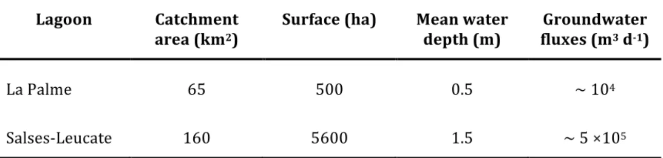
Cette thèse a été réalisée dans les étangs de La Palme et de Salses-Leucate situés dans le sud-ouest de la France sur la façade méditerranéenne. L’étang de La Palme est relativement petit (superficie 500 ha; profondeur moyenne 0.5 m; volume d’eau ~3×10³ m3) (Wilke and Boutière 2000) et très connu par sa haute
biodiversité et haute valeur écologique. Il est alimenté en eaux douces grâce à plusieurs résurgences karstiques localisées dans la partie nord-ouest avec un débit moyen de 104 m3 j-1 (Wilke and Boutière 2000; Stieglitz et al. 2013). Une station
d’épuration d’eaux usées déverse des eaux usées traitées dans la partie nord de l’étang avec un débit moyen de 102 m3 j-1. La recirculation d’eau de la lagune est
L’étang de Salses-Leucate est plus grand (5600 ha) et plus profond (profondeur moyenne: 1.5 m). Il est connecté avec la Mer Méditerranée par trois ouvertures dans la partie Est de l’étang. La principale zone d’étude est la partie ouest qui est alimentée en eau douce par deux résurgences karstiques Font Dame et Font Estramar qui ont des débits de 3.0 × 10⁵ m3 j-1 et 2.0 × 10⁵ m3 j-1 respectivement.
Une station d’épuration d’eau déverse aussi d’eau douce sur la partie de sud-ouest de l’étang. - Quantification des flux de nutriments associés aux eaux souterraines et eaux porales Cette étude a pour objectif de quantifier les flux des nutriments apportés par les eaux souterraines et la recirculation (eaux porales) dans l’étang de La Palme. L’étude a été effectuée sur le bassin nord de l’étang qui représente 85% de la superficie et 95% du volume d’eau de l’étang, et reçoit tous les apports en eau souterraine de la résurgence karstique. L’approche consiste à utiliser le radon (222Rn) qui est un traceur radioactif naturel à courte période, utilisé globalement
pour tracer et quantifier la décharge d’eau souterraine dans les zones côtières (Burnett and Dulaiova 2003; Stieglitz et al. 2010). Des bilans de masse de masse d’eau et de radon ont été effectués pour quantifier les flux des eaux souterraines karstiques et la circulation à travers le sédiment en supposant un état stationnaire, c’est-à-dire un équilibre entre les termes sources et les termes puits. Des campagnes de terrain ont été réalisées en Juin 2016, Novembre 2016, Avril 2017 et Juin 2017 pour effectuer une mesure continue de la distribution spatiale du radon à l’aide des compteurs RAD7 (Durridge) branchés en parallèle et connectés avec une membrane (Dulaiova et al. 2005; Stieglitz 2005). La salinité et la température de l’eau ont été également mesurées en continue avec une sonde WTW multiparamètre. Parralèlement des échantillons ont été collectés pour la détermination des concentrations en radon et en éléments nutritifs (NO3-, NH4+ et
PO43-) dans la résurgence, les eaux usées et à trois points de l’étang. Des
échantillons d’eau porale ont été aussi prélevés à différentes profondeurs dans les trois stations de la lagune pour les analyses de radon, salinité et nutriments dans les eaux interstitielles.
Nos résultats montrent que la salinité des eaux porales augmente avec la profondeur, reflètant un mélange d’eau de la lagune avec une eau porale profonde hypersalée (salinité jusqu’à 80). Les eaux porales sont enrichies en radon avec des concentrations maximales de 6800 ± 600, 4600 ± 400 et 8000 ± 900 Bq m-3 pour
les trois stations étudiées alors que les concentrations dans les eaux de surface sont relativement faibles (20-200 Bq m-3). Les concentrations en NH4+ et PO43- sont
également très élevées dans les eaux porales comparées à celles des eaux de surface et augmentent avec la profondeur dans le sédiment. Cependant, les concentrations en NO3- dans les eaux porales sont comparables voire inférieures à celles des eaux de surface. Pour les échantillons de surface, des fortes concentrations en radon (jusqu’à 300 Bq m-3 en juin 2016) et de faible salinité (jusqu’à 17 en Avril 2017) sont observées dans la partie nord de l ‘étang proche de la source karstique, avec une diminution des concentrations en radon et augmentation de la salinité vers le sud de la lagune. Dans la résurgence, la salinité varie de 5.0 à 9.4 selon la saison, indiquant une interaction entre eaux souterraines douces et eaux de mer dans l’aquifère. Les concentrations en radon dans la source sont relativement constantes tout au long de l’année et considérablement enrichies par rapport aux concentrations de la lagune, avec des valeurs de 2290 ± 90 à 2600 ± 110 Bq m-3. Les concentrations en
NO3- sont considérablement élevées dans la résurgence (50-62 µmol L-1) et les
eaux usées (100-520 µmol L-1) comparées à celles de la lagune (0.1-7.8 µmol L-1),
entrainant un important gradient de concentrations corrélé à la valeur de salinité. Les concentrations en NH4+ dans la résurgence (0.1-0.5 µmol L-1) et les eaux usées
(2.6-16 µmol L-1) sont comparables voire inférieures à celles de la lagune (0.8 – 36
µmol L-1) alors que celles en PO43- sont largement plus élevées dans les eaux usées
(22-71 µmol L-1) que dans la résurgence (0.1-0.4 µmol L-1) et la lagune (0.1-2.5
µmol L-1). Par conséquent, la résurgence et les eaux usées ne sont pas des sources
importantes de ces éléments nutritifs pour la lagune et les fortes concentrations observées dans l’étang suggèrent l’existence d’autres sources qui peuvent être la diffusion et/ou la recirculation.
Le bilan de masse d’eau révèle des flux d’eau souterraine de 3 ± 15 × 103 m3 j-1 en
des estimations antérieures menées à l’étang de La Palme (Wilke and Boutière 2000; Stieglitz et al. 2013). Le bilan de masse de radon révèle par contre des flux de recirculation de 42 ± 33 × 103 à 89 ± 44 × 103 m3 j-1.
En multipliant ces flux d’eau avec les concentrations dans les endmembers (source karstique et eaux interstitielles), les flux de nutriments ont pu être estimés. La recirculation représente une importante source de NH4+ (1900-5500 mol j-1) et de
PO43- (27-71 mol j-1) et la résurgence karstique constitue une importante source de
NO3- (200-1200 mol j-1), en comparaison avec les autres sources (diffusion, eaux
usées et déposition atmosphérique). En somme, la recirculation représente plus de 80% de l’apport total en azote inorganique dissous et plus de 50% de l’apport total en phosphore inorganique dissous dans la lagune de La Palme.
Cette étude permet alors de mettre en exergue le rôle des eaux souterraines et la recirculation comme une importante source de nutriments dans l’étang de La Palme et qu’il est nécessaire d’évaluer les effets écologiques de ces eaux souterraines pour une bonne gestion des écosystèmes lagunaires.
- Rôle des eaux souterraines et des eaux porales dans le soutien de la production primaire
Cette étude a pour objectif d’évaluer le rôle des eaux souterraines karstiques et des eaux porales (recirculation) dans le soutien de la production primaire dans les lagunes de La Palme et de Salses-Leucate. Le transfert de l’azote et du carbone inorganique dissous des eaux souterraines et des eaux porales vers les macrophytes et phytoplancton a été examiné à l'aide de variations d’abondance naturelle des isotopes de l‘azote (δ15N) et du carbone (δ13C).
Des campagnes de terrain ont étaient menées sur les deux lagunes en Juin 2016, Novembre 2016 et Juin 2017 et en Avril 2017 (pour l’étang de La Palme uniquement). Des échantillons d’eau de surface ont été collectés dans plusieurs stations des lagunes, les résurgences karstiques et les stations d’épuration d’eaux usées pour quantifier les signatures isotopiques de l’azote inorganique (sous forme de nitrate δ15N-NO3-) et du carbone inorganique (δ13C-DIC). Les signatures
(δ15N-DIN). En outre, des macrophytes et des matières particulaires (assimilées la
population phytoplanctonique) ont été collectés dans les lagunes, les résurgences karstiques et dans les stations d’épuration pour la quantification des isotopes de l’azote (δ15N) et du carbone (δ13C).
Les résultats montrent que les sources étudiées d’azote inorganiques des deux lagunes (résurgences karstiques, eaux porales et les eaux usées) ont des δ15N
distinctement différentes, permettant ainsi l’identification de l’origine de l’azote dans différentes zones des étangs. Les sources karstiques ont une valeur moyenne de δ15N-NO3- de 3.1 ± 2.1‰ (=n=4) à l’étang de La Palme et 1.0 ± 1.2‰ (n=5) à
Salses-Leucate. Les δ15N-DIN (NO3- + NH4+) des eaux porales sont significativement
plus élevées (7.1 ± 3.3‰; n=12) et 6.4 ± 2.1‰ (n=3) dans les lagunes La Palme et Salses-Leucate respectivement. Par ailleurs, les NO3- des eaux usées sont beaucoup
plus enrichies en δ15N avec des valeurs moyennes de 16.4 ± 4.5‰ (n=3) dans
l’étang de La Palme et 17.6 ± 3.7‰ (n=2) dans l’étang de Salses-Leucate. Les δ15N
dans les macrophytes et des matières en suspension sont en générale plus proches de celles des résurgences karstiques et des eaux porales, avec quelques exceptions. Ce constat tend à indiquer que l’azote apporté par les eaux usées ne supporterait qu’une faible part de la croissance des organismes végétaux des étangs qui obtiennent la majorité de leur azote inorganique des résurgences karstiques et/ou des eaux porales. Une élévation exceptionnelle des valeurs de δ15N des
producteurs primaires a été enregistrée pendant l’été et ceci est attribué à l’augmentation de flux d’eaux usées pendant cette période. A noter qu’à l’étang de La Palme, les signatures isotopiques de l’azote des eaux souterraines et des eaux porales sont relativement proches et c’est difficile de les séparer. Par contre à l’étang de Salses-Leucate, les signatures sont distinctes et les influences des eaux souterraines karstiques se limitent seulement aux endroits proches des résurgences et les eaux porales semblent être la principale source d’azote inorganique pour les producteurs primaires.
Les signatures isotopiques du DIC (δ13
C-DIC) dans les étangs de La Palme et Salses-Leucate augmentent généralement avec la salinité et montrent un mélange conservatif entre les eaux souterraines karstiques et l’eau de mer. Ce qui indique que les eaux souterraines et les eaux marines sont des importantes sources de DIC
dans les lagunes. Le flux important de DIC provenant du sédiment ((20-120) × 103
mol j-1) nous montre aussi que les eaux porales sont aussi des sources
non-négligeables de DIC.
Les macrophytes et les matières en suspension (phytoplankton) se trouvant proche des résurgences karstiques ont des faibles δ13C alors que ceux qui sont
dans la partie marine ont des signatures élevées indiquant que les producteurs primaires se trouvant proches des résurgences karstiques obtiennent la majorité de leur carbone inorganique de ces résurgences tandis que ceux qui se trouvent dans la partie marine dépendent du carbone inorganique qui est en équilibre avec le CO2 atmosphérique. Avec un important flux de DIC des eaux porales, les eaux
porales constituent également une importante source de DIC pour ces producteurs primaires.
Pour conclure, cette étude met en évidence le rôle des eaux souterraines karstiques et des eaux porales dans le soutien de la production primaire dans les lagunes de La Palme et Salses-Leucate. Le traçage de l’azote montre que les résurgences karstiques et les eaux porales sont les principales sources de d’azote inorganique pour les producteurs primaires. Les résurgences karstiques, les eaux porales et l’eau de mer en échange avec l’atmosphère sont les principales sources de carbone inorganique pour les producteurs primaires dans les lagunes de La Palme et Salses-Leucate.
- Rôle des eaux souterraines sur la croissance des moules méditerranéennes
L’objectif de cette étude est d’évaluer l’influence des eaux souterraines sur la croissance des moules méditerranéennes (Mytilus galloprovincialis) dans la lagune côtière de Salses-Leucate (France). Le taux de croissance et l’indice de condition (poids des tissus / poids de la coquille) des moules se développant dans les sites influencés par les eaux souterraines et dans un site témoin hors influence des eaux souterraines ont été examinés.
Des individus de Mytilus galloprovincialis ont été récoltés à l’état sauvage dans l’étang de Salses-Leucate dans deux stations influencées par les résurgences de
Font Dame et Font Estramar et dans un site témoin hors influence des eaux souterraines. Les moules collectées ont été marquées avec de la calcéine qui est un colorant fluorescent, permettant de situer temporellement une strie de croissance donnée. Les moules marquées ont été placées dans des cages et remises dans leurs habitats originaux. Deux cages ont été utilisées (à 20 et 50 cm du fond) dans les sites influencés par les résurgences et une seule cage dans le site témoin (pas de stratification de la colonne d’eau). Des sondes CTDs ont été installées sur chaque cage pour enregistrer les données horaires de salinité, température et profondeur. Les autres données environnementales ont été récupérées au niveau de la station météorologique Météo-France à Leucate. L’étude a été réalisée sur une période de 20 mois avec une première mise en cage le 10/10/2016 sur les sites influencés par les résurgences et le 17/02/2017 pour le site témoin. Des collectes ont été ainsi organisées le 14/01/2017, le 27/03/2017, le 29/11/2017 et le 29/01/2018. Le taux de croissance de chaque individu a été calculé à partir de la distance mesurée entre la position du marquage et le bord de la coquille lors du jour de la collecte. Le nombre de stries entre le marquage et la collecte de chaque individu a été également compté pour estimer le nombre d’incréments fabriqués sur une échelle de temps régulière. Les courbes de croissance des moules Mytilus
galloprovincialis ont été reconstruites en utilisant le modèle de Von Bertalanffy
décrit dans Nedoncelle et al. (2013). Les résultats de nos modèles ont été également comparés avec les modèles obtenus pour la même espèce dans la région méditerranéenne.
Les résultats montrent que les moules Mytilus galloprovincialis de l’étang de Salses-Leucate ont tendance à suivre un rythme diurne pour la fabrication de leur incrément de croissance. L’effet de marée est insignifiant dans la lagune de Salses-Leucate due une faible influence de la marée en Mer Méditerranée. Ceci s’oppose généralement aux croissances des moules en milieu marin sous influence de la marée, qui suivent un cycle semi-diurne (deux incréments de croissance par jour). La périodicité journalière de la formation d’incrément de croissance des moules dans l’étang de Salses-Leucate est liée l’horloge biologique de l’animal (Schöne 2008; Connor and Gracey 2011). La biologie de beaucoup d’organismes est liée aux
variations des conditions environnementales qui présentent d’une manière générale un cycle journalier, particulièrement pour la température et la lumière. Les courbes de croissance de Von Bertalanffy démontrent que les taux de croissance des Mytilus galloprovincialis dans la lagune de Salses-Leucate comptent parmi les taux les plus élevés enregistrés dans la région méditerranéenne, particulièrement dans les sites influencés par les résurgences. Les moules à Salses-Leucate montrent une forte croissance juvénile et les tailles maximales sont atteintes dans les jeunes âges, ce qui indique que la lagune de Salses-Leucate est favorable pour la croissance de ces moules. Les analyses de croissance révèlent que les moules provenant des sites influencés par les résurgences ont un taux de croissance (41.9 ± 1.9 μm j-1) et un indice de condition élevés (9.1 ± 0.4) comparé à
ceux du site témoin hors influence des eaux souterraines (taux de croissance: 27.7 ± 2.0 μm d-1; indice de condition: 5.8 ± 0.4). Ce développement plus efficace est
probablement dû aux températures hivernales plus élevées dans les sites influencés par les eaux souterraines (Page and Hubbard 1987; Schöne et al. 2003a). Ce taux de croissance élevé peut être aussi expliqué par la disponibilité en nourriture dans ces sites. Les résurgences sont reconnues comme une importante source de nutriments en milieu lagunaire, favorisant ainsi une grande productivité primaire (Tamborski et al. 2018; Rodellas et al. 2018). Bien que l’apport d’eau douce par les résurgences puisse avoir des effets négatifs sur la croissance des
Mytilus galloprovincialis (His et al. 1989; Vuorinen et al. 2002), nos résultats
montrent une forte croissance dans les sites influencés par ces résurgences. Ce qui suggère que les moules sont peut-être acclimatées à la dessalure ou bien que les effets de la salinité sont négligeable comparés à ceux de la température et de la disponibilité en nourriture.
Une baisse de la production en moule est actuellement observée, due au manque de sites favorables pour la mytiliculture, liée à une forte pression anthropique. Identifier des sites appropriés pour la mytiliculture demeure un grand défi pour les producteurs de moules. Nos résultats montrent que les sites influencés par les résurgences sont des sites potentiels pour l’élevage de moules, en particulier au voisinage des eaux oligotrophes telles que la Mer Méditerranée. Donc outre son
rôle écologique, les eaux souterraines peuvent aussi avoir des effets économiques non négligeable en milieux lagunaires.
Conclusion
Pour conclure, cette thèse montre que les eaux souterraines et la recirculation (eaux porales), sont des importantes sources de nutriments dans les lagunes de La Palme et Salses-Leucate. Nos résultats mettent en évidence que la recirculation d’eau salée de la lagune à travers les sédiments est la principale source d’azote (essentiellement sous forme d’ammonium) et de phosphore inorganiques dissous dans les lagunes côtières. Cet important apport en éléments nutritifs a un effet sur le fonctionnement écologique de ces écosystèmes lagunaires. Dans un premier temps, les variations d’abondance naturelle des isotopes de l’azote et du carbone montrent que les macrophytes et phytoplancton des lagunes de La Palme et Salses-Leucate obtiennent la majorité de leur azote à partir des eaux souterraines karstiques et des eaux porales (recirculation) et la majorité de leur carbone à partir des résurgences karstiques, des eaux porales et l’eau de mer en échange avec l’atmosphère. Dans un deuxième temps, les moules des sites influencés par les eaux souterraines ont un taux de croissance et un indice de condition plus élevés que celles du site témoin hors influence des eaux souterraines. Les taux de croissance estimés pour les sites influencés par les eaux souterraines comptent parmi les taux les plus élevés enregistrés dans la région méditerranéenne. Ces résultats démontrent le rôle important que peuvent jouer les apports d’eaux souterraines dans le fonctionnement des écosystèmes lagunaires côtiers.
Acknowledgements
We used to say that it’s not the destination but the journey that truly matters. I enjoy the road but I never took such a long and a bumpy one, so it feels good to finally reach the end of it. This PhD was not only a scientific adventure but a human one as well. I met many people along the way and would never made it without their support and help.
First and foremost, I would like to sincerely thank my supervisors Thomas Stieglitz and Patrick Raimbault for giving me the chance to carry out such an interesting study and for their guidance, help and constructive feedback during my PhD. I would like to especially express my gratitude to Thomas Stieglitz for encouraging my research and allowing me to grow as a research scientist.
I would like to express my gratitude to Valentí Rodellas, for always being there to help, for always sharing his knowledge and for all the good moments during the field campaigns. Your friendly advice made my journey much more enjoyable. I would like to acknowledge Franck Lartaud (LECOB) for the warm welcome in his lab, the training on sclerochronology and the immense scientific support. I would like to thank my PhD thesis committee (Peter Cook, Rutger de Wit, Florence Sylvestre, Dominique Munaron and Vincent Bailly-Comte) for their guidance throughout the progress of this work. Many thanks for Nicole Garcia (MIO) for the help with the nutrient analysis. I would like to thank Marine David, Simon Benjannin, Joe Tamborski, Camille Fleger (Parc Naturel Narbonnaise) and Laurence Fonbonne (Rivage Leucate), Henry Comte and Michel for their support during field campaigns. A big thank to Christophe Monnin for sharing the carbon data from La Palme lagoon. I would also like to thank Ingrid Neuveu for the help with the sclerochronological analysis.
Big thanks for my office mates Chloe Poulin and Wuhib Tamrat for the warm welcome at the office 109. Their kindness, constant good mood and good jokes made these three years great moments. I would like to thank the administrative and technical staff of CEREGE. I would also like to thank everyone that I had close contact with at CEREGE: Ross, Ricardo, Maureen, Julie, Eléonore, Noémie, Patricia,
Franck, Jesus, they made that three years pass like three months. I would also like to thank Céline, Amandine, Nicolas L., Benjamin, Brina, Rachid, Abdallah, Kevin, Agathe, Clémént O., Marie, Jonathan, Daniele, Abel and Claire for their time and friendship. Thanks a lot for Jérome, Clément, Vlad, Yoann and Vincent for the Thursday football.
Funding for this PhD research was provided by the French National Research Agency (ANR) through ANR @RAction chair medLOC (ANR-14-ACHN-0007-01) which is hereby acknowledged. I would also like to thank my family for supporting me endlessly through my PhD journey. Special gratitude and thanks to my mother, your prayers have sustained me this far. My older Brother Tsiry, you inspired and encouraged me to undertake my PhD, your effective advice and support have always led me towards my goals. To Larissa, thank you for always being there for me and bringing a smile to my face during the ups and downs that come with undertaking a PhD degree. I would also like to thank Colin and Iphigénie for their constant support. Last but not least, I would like to thank all my friends and family from Madagascar, Marseille, Aix-en-Provence, Paris, Brussels or somewhere else for the tremendous help and support during all these years. MISAOTRA BETSAKA!
Table of contents
Abstract ... 1 Extended summary in French ... 3 Acknowledgements ... 13 Table of contents ... 15 List of figures ... 17 List of tables ... 21 Preface ... 22 Chapter 1: Introduction ... 30 1.1 Coastal lagoons ... 31 1.1.1 General characteristics ... 31 1.1.2 Classification ... 32 1.1.3 Ecological characteristics ... 34 1.1.4 Threats to coastal lagoons ... 36 1.2 Groundwater processes ... 39 1.2.1 Terrestrial groundwater and porewater fluxes (recirculation) ... 39 1.2.2 Quantification techniques ... 39 1.2.3 Groundwater- and recirculation-driven nutrient in coastal ecosystems ... 42 1.3 Study site description ... 52 1.3.1 French Mediterranean coastal lagoons ... 52 1.3.2 La Palme lagoon ... 54 1.3.3 Salses-Leucate lagoon ... 56 Chapter 2: Groundwater-driven nutrient inputs to coastal lagoons: the relevance of lagoon water recirculation as a conveyor of dissolved nutrients 60 2.1 Introduction ... 61 2.2 Theory ... 63 2.2.1 Concurrent water and radon mass balances for surface waters ... 63 2.3 Methods ... 64 2.3.1 Porewater collection and analysis ... 64 2.3.2 Surface water collection and analysis ... 66 2.3.3 Ancillary measurements and analysis ... 68 2.3.4 Radon equilibration experiment ... 70 2.4 Results ... 71 2.4.1 Porewater profiles ... 71 2.4.2 Radon and salinity distributions in lagoon surface waters ... 74 2.4.3 Nutrients in lagoon surface waters ... 77 2.4.4 Estimation of karstic groundwater and recirculation inputs from water and radon mass balances ... 79 2.4.5 Nutrient fluxes from karstic groundwater and recirculation ... 85 2.5 Discussion ... 87 2.5.1 Uncertainties on estimated radon, water and nutrient fluxes from recirculation ... 87 2.5.2 Nutrient fluxes to La Palme lagoon ... 91 2.5.3 The role of lagoon water recirculation as nutrient source ... 96 2.6 Conclusions ... 98 Chapter 3: Primary production in coastal lagoons supported by groundwater discharge and porewater fluxes inferred from nitrogen and carbon isotope signatures ... 993.2 Materials and Methods ... 103 3.2.1 Nutrient sources ... 103 3.2.2 Sample collection and analysis ... 104 3.3 Results ... 107 3.3.1 NO3- and NH4+ concentrations ... 107 3.3.2 Source isotopic signatures ... 109 3.3.3 δ15N in macrophytes and POM ... 112 3.3.4 δ13C in macrophytes and POM ... 113 3.3.5 Interspecific variations in isotopic signature in macrophytes ... 115 3.4 Discussion ... 115 3.4.1 Processes affecting macrophyte and phytoplankton δ15N ... 115 3.4.2 Macrophyte and phytoplankton carbon uptake and isotope signature ... 123 3.5 Conclusion ... 127 Chapter 4: Enhanced growth rate of the Mediterranean mussel in a coastal lagoon driven by groundwater inflow ... 129 4.1 Introduction ... 130 4.2 Materials and Methods ... 131 4.2.1 Study sites ... 131 4.2.2 Installation of mussel cages and monitoring of environmental parameters 132 4.2.3 Sample preparation ... 136 4.2.4 Condition Index ... 137 4.2.5 Growth analyses ... 138 4.2.6 Growth curves ... 138 4.2.7 Statistical analyses ... 139 4.3 Results ... 140 4.3.1 Condition index ... 140 4.3.2 Shell growth rate ... 141 4.3.3 Growth curves ... 141 4.3.4 Growth increments ... 143 4.3.5 Environmental parameters ... 145 4.4 Discussion ... 150 4.4.1 Periodicity in shell growth and environmental influences ... 150 4.4.2 Growth of M. galloprovincialis in the Mediterranean region ... 152 4.4.3 Role of groundwater discharge ... 153 4.4.4 Economic implications ... 156 4.5 Conclusion ... 157 Chapter 5: Conclusion and perspectives ... 158 5.1 Conclusion ... 159 5.1.1 Quantification of nutrient fluxes from groundwater discharge and recirculation (Chapter 2) ... 159 5.1.2 Role of groundwater discharge and porewater fluxes in supporting primary production (Chapter 3) ... 160 5.1.3 Effects of groundwater discharge in the growth of the Mediterranean mussels (Chapter 4) ... 161 5.2 Research perspectives ... 162 References ... 164
List of figures
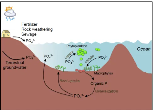
Figure 1.1| World distribution of coastal lagoons (De Wit 2011). Black areas represent coastal lagoons. ... 32 Figure 1.2| Geomorphic types of coastal lagoons (chocked, restricted and leaky) based on water exchange with the coastal ocean (Kjerfve 1994; Duck and Silva 2012). In this thesis, a choked (La Palme) and a restricted (Salses-Leucate) lagoons were studied.33 Figure 1.3| Coastal lagoon with associated ecological characters and potential environmental impacts (Adapted from SUPAGRO 2016). ... 36 Figure 1.4| Diagram summarizing the major N cycle pathways in coastal lagoon ... 43 Figure 1.5| Diagram summarizing the major P cycle pathways in coastal lagoons ... 47 Figure 1.6| Conceptual model (not to scale) of silicate flux in a coastal surface
water-groundwater system. The average and standard deviation of dissolved silica (in μM), salinity and number of samples are shown for each compartment. F1: terrestrial groundwater, F2: groundwater entering the ocean, F3: recirculation and F4: the flux to the ocean (Sospedra et al. 2018). ... 48 Figure 1.7| Relationship between pCO2 and 222Rn (natural groundwater tracer) in March
and May 2012 in a coastal floodplain creek in South Wales, Australia (Atkins et al. 2013). ... 49 Figure 1.8| Diagram summarizing the major C cycle pathways in coastal lagoons. Based on Alin et al. (2012). ... 50 Figure 1.9| Relations between Chl-a (primary production proxy) and 223Ra (a natural
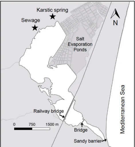
groundwater tracer). Dashed line represents the best linear fit to the data (Rodellas et al. 2014b). ... 51 Figure 1.10| Geographical situation of the French Mediterranean coastal lagoons (Le Fur et al. 2019). ... 53 Figure 1.11| Map of La Palme lagoon. Locations of sewage treatment plant and groundwater springs are shown. ... 56 Figure 1.12| Map of Salses-Leucate lagoon. Locations of sewage treatment plant and groundwater springs are shown. ... 59 Figure 2.1| Study site (La Palme lagoon) location on the French Mediterranean coastline. Sampling locations for endmembers (karstic spring, sewage effluent and seawater) and porewaters (piezometer) are shown, as well as the position of monitoring stations from the “Parc Naturel Régional de la Narbonaisse en Méditerranée” (PN station) and the site where the current meter was installed. ... 66
Figure 2.2| Sampling campaign in La Palme lagoon. (a) Porewater sampling using a direct-push, shielded-screen well-point piezometer, (b) radon and salinity mapping, (c) two RAD7 monitors connected in parallel, (d) karstic groundwater spring, (e) radon sampling in the lagoon with submersible pump, and (f) counting of radon samples. . 68
Figure 2.3| Precipitation surface water level and salinity in La Palme lagoon during 2016 and 2017 (Precipitation data from “Météo France”; surface water depth and salinity data from the three monitoring stations of PNRNM, see Fig. 2.1). Periods of the surveys are indicated. ... 70 Figure 2.4| Depth profiles (in cm below the sediment-water interface) of salinity and radon concentration in porewater for the three piezometers collected at each campaign. Reported values at a depth of 0 cm corresponds to the samples collected in surface waters (~10 cm above the sediment-water interface). The gray area represents radon concentration in equilibrium with sediments estimated from equilibration experiments. ... 72 Figure 2.5| Depth profiles (in cm below the sediment-water interface) of dissolved inorganic nutrient (NO3-, NH4+ and PO43-) concentrations in porewater for the three
piezometers collected at each campaign. Reported values at a depth of 0 cm corresponds to the samples collected in surface waters (~10 cm above the sediment-water interface). Note that nutrient samples at Pz1 were not analyzed for the April 2017 survey. ... 73 Figure 2.6| Seasonal distribution of radon and salinity and water levels in the northern basin of La Palme lagoon. Points used to derive the interpolation for salinity and radon grids are shown. The main karstic spring is indicated with a black star. ... 75 Figure 2.7| Dissolved inorganic nutrient (NO3-, NH4+ and PO43-) concentrations in lagoon
waters, the karstic spring, the sewage effluent and seawater endmembers, as a function of water salinity. The gray area represents the range of nutrient concentrations and salinities covering 66% of porewater samples (it extends to a salinity of 61 and to a NH4+ concentration of 180 µmol L-1). ... 78
Figure 2.8| Evolution of water depths in the northern basin of La Palme lagoon in April and June 2017. Average changes in lagoon water level over time derived from linear regressions (-0.0034 and -0.0054 m d-1 for April and June 2017, respectively) were
used to estimate ∂VN ∂t for April 2017 and June 2017 campaigns. The short-term variations on water depth are likely produced by rapidly changing wind conditions and are expected to have a minor influence on the water mass balance. ... 80 Figure 2.9| Concentration of NH4+ and PO43- plotted against radon concentrations in
porewaters, arranged by piezometer and sampling campaign. ... 90 Figure 2.10| Fluxes of dissolved inorganic nutrients to the northern basin of La Palme lagoon driven by terrestrial groundwater discharge, lagoon water recirculation, diffusion, inputs from the sewage treatment plant and atmospheric deposition estimated for the different surveys. Boxes cover the range between minimum and maximum estimates (negative values not included), and black lines represent the average value. Inputs from atmospheric deposition on NO3- and NH4+ panels refer to
total DIN fluxes. ... 93 Figure 3.1| Sampling locations overlaid on the surface salinity distribution (June 2016) in (a) La Palme and (b) Salses-Leucate lagoons (modified from Rodellas et al 2018). Locations of sewage treatment plants (STP) and groundwater springs are shown. 105
Figure 3.2| (a) Reduction / diffusion method for measurement of the δ15N of NO3- and
DIN, (b) macrophyte samples in karstic spring, (c) grounded macrophyte samples for stable isotope analyses and (d) stable isotope analyses on elemental analyzer mass spectrometer Integra CN Sercon. ... 107 Figure 3.3| (a, b) Variation of NO3-, (c, d) NH4+ concentrations and (e, f) the stoichiometric
ratios of DIN:DIP along the salinity gradient in La Palme and Salses-Leucate lagoons, respectively. The dashed lines represent the DIN:DIP Redfield ratio of 16:1. Endmembers indicate the average NO3- and NH4+ concentrations and the DIN:DIP
ratios in the sewage effluents (black triangle), springs (red circle) and seawater (orange diamond). NO3- and NH4+ concentrations and DIN:DIP data in the lagoons
(green diamond) and the creeks (blue square) are not differentiated for the four sampling campaigns. Note the scale differences on the y-axes and the axis breaks. 108 Figure 3.4| (a) The δ15N of nitrogen (δ15N-NO3- for sewage and groundwater samples;
δ15N-DIN for porewater samples) and (b) the δ13C of DIC sources measured in La
Palme and Salses-Leucate lagoons compared with nitrogen sources in literature. The isotopic signatures of the nitrogen sources (sewage, porewater and springs) and carbon sources (sewage, groundwater and seawater in equilibrium with the atmospheric CO2) measured in this study are in good agreement with values reported
in the literature (Atekwana and Krishnamurthy 1998; Chanton and Lewis 1999; Cole et al. 2005; Kendall et al. 2007; Yang et al. 2008; Barros et al. 2010). ... 111 Figure 3.5| δ13
C of DIC in water along the salinity gradient in (a) La Palme and (b) Salses-Leucate lagoons. Endmembers indicate the average δ13C-DIC in the sewage effluents
(black triangle), springs (red circle) and seawater (orange diamond). δ13C-DIC
samples are not differentiated for the four sampling campaigns. The black lines represent the conservative binary isotopic mixing line between δ13C-DIC in karstic
groundwater and seawater endmembers, derived using the DIC concentrations in groundwater (5900 ± 800 µmol L-1) and in seawater (2300 ± 200 µmol L-1) (C.
Monnin, unpublished data) (Chanton and Lewis 1999). ... 112 Figure 3.6| The δ15N of (a, b) macrophytes and (c, d) POM along the salinity gradient in La
Palme and Salses-Leucate lagoons, respectively. Endmembers indicate the average δ15N of primary producers sampled close to the sewage outlet (black triangle),
springs (red circle) and seawater (orange diamond). The δ15N data from primary
producers are shown together for the four sampling campaigns. ... 113 Figure 3.7| The δ13C of (a, b) macrophytes and (c, d) POM along the salinity gradient in La
Palme and Salses-Leucate lagoons, respectively. Endmembers indicate the average δ13C of primary producers in the sewage effluents (black triangle), springs (red
circle) and seawater (orange diamond). The shown δ13C data from primary
producers are shown together for the four sampling campaigns. Note the scale difference for the y-axes. ... 114 Figure 3.8| The δ15N of macrophytes and POM (phytoplankton) in (a) La Palme and (b)
Salses-Leucate lagoons, together with the isotopic signatures measured in inorganic nitrogen dissolved in water from the three identified sources. The nitrogen isotopic signatures are measured values and thus are not corrected for fractionation. ... 122
Figure 3.9| The δ13C of Macrophytes (a, b) and POM (c, d) versus δ13C-DIC in lagoon water
from La Palme and Salses-Leucate lagoons, respectively. Endmembers indicate the average δ13C of primary producers in the sewage effluents (black triangle), springs
(red circle) and seawater (orange diamond). δ13C data from primary producers in the
lagoons (green diamond) and the creeks (blue square) are shown together for the four sampling campaigns. Note the scale difference on the y-axes. ... 127 Figure 4.1| Salses-Leucate lagoon location on the French Mediterranean coastline. The groundwater-influenced sites (Font Dame and Font Estramar) and control site (Port Fitou) are shown, as well as the groundwater springs and the meteorological station. ... 132 Figure 4.2| (a) Mussels collected from the lagoon, (b) calcein marking, (c) cage installation and (d) cage with CTD loggers. ... 134 Figure 4.3| (a) Mussel section along the maximum growth axis, (b), section mounted on glass slide showing the shell length (Lt = L + L∆t), (c) shell under natural light showing the calcein marking and (d) the shell under fluorescent light showing growth increments. ... 137 Figure 4.4| (a) Mean (± SD) condition indices and (b) growth rate in
groundwater-influenced sites (FDS: Font Dame Surface, FDD: Font Dame Deep, FES: Font Estramar Surface and FED: Font Estramar Deep) and the control site (PF: Port Fitou) in Salses-Leucate lagoon. The asterisk indicates that p is less than 0.05 for the Student’s t-test between groundwater-influenced sites and control site (condition index: groundwater influenced-sites n=119, control site n=30, t-test, t=5.93, p<0.05; growth rate: groundwater influenced-sites n=74, control site n=8, t-test, t=5.24, p<0.05). . 140 Figure 4.5| Von Bertalanffy growth curves of Mytilus galloprovincialis from the groundwater-influenced sites and the control site in Salses-Leucate lagoon and from other coastal systems in the Mediterranean region with 1: groundwater-influenced sites in this study (K=0.54, L∞=75.0); 2: control site in this study (K=0.46, L∞=63.9); 3: semi-enclosed basin in Italy (K=0.09, L∞=62.1, Posa and Tursi 1991); 4: coastal basin in Italy (K=0.10, L∞=58.7, Posa and Tursi 1991); 5: coastal bay in Italy (K=0.03, L∞=51.3, Sarà et al. 2012); 6: coastal bay in Spain (K=0.76, L∞=85.0, Ramón et al. 2007), 7: coastal lagoon in Italy (K=0.66, L∞=85.9, Ceccherelli and Rossi 1984) and 8: coastal area in Algeria (K=0.31, L∞=64.0, Abada-Boujemaa Y. M. 1996). Shaded areas represent the standard deviations of data obtained in the present study. ... 142 Figure 4.6| Left panel: increment number from the calcein mark (right side) to the collection (left side) for three representative Mytilus galloprovincialis shells S1 (FDS0118-3), S2 (FDD0118-4) and S3 (PF0118-3) between June 2017 and January 2018. Right panel: Fast Fourier Transform showing the periodicities of the increment width. ... 144 Figure 4.7| Temporal variations between October 2016 and January 2018 in (a) precipitation, (b) wind speed, (c) water depth, (d) temperature and (e) salinity in Salses-Leucate lagoon: Font Dame Surface (FDS), Font Dame Deep (FDD), Font Estramar Surface (FES), Font Estramar Deep (FED) and Port Fitou (PF). The salinity
data shows large variability and presents similar seasonal pattern for surface and bottom cages. For clarity, we present the surface water salinity only. ... 147 Figure 4.8| (a, b, c) Fast Fourier Transformations of the temperature, (d, e, f) salinity and (g, h, i) water depth at Font Dame (FD), Font Estramar (FE) and Port Fitou (PF), and (j) the wind speed at the study. Arrows indicate peaks of the power spectrum. ... 149
List of tables
Table 1.1| Dissolved nitrogen (NO3- + NH4+) concentrations in groundwater and surface
seawater in coastal systems. ... 43 Table 2.1| Definition of the terms and values used in the mass balances for water and radon based on Equations 2.1 and 2.2. The terms estimated from the mass balance are highlighted in bold. ... 76 Table 2.2| Summary of the approaches used to estimate values and uncertainties of all the terms used on Equations 2.1-2.4. ... 84 Table 2.3| Water flows, endmember nutrient concentrations and nutrient fluxes from karstic groundwater and lagoon water recirculation to the northern basin of La Palme lagoon for the different surveys. The recirculation nutrient endmember refers to weighted-average excess nutrient concentrations (samples collected at 5 cm below the sediment-water interface at each piezometer) for each survey. ... 86 Table 4.1| The shell length mean (Mean ± SD) and range (Min-Max), and the number (n) of mussels installed / collected from the cages with collection date from the different stations in Salses-Leucate lagoon: FDS: Font Dame Surface, FDD: Font Dame Deep, FES: Font Estramar Surface, FED: Font Estramar Deep and PF: Port Fitou. ... 135 Table 4.2| The Von Bertalanffy growth parameters and the growth performance indices values of M. galloprovincialis from this study and other coastal systems in the Mediterranean region. ... 143
PREFACE
Coastal lagoons are highly dynamic transitional (brackish) water bodies, which are controlled by physical processes of both marine and terrestrial origin. They are among the most productive ecosystems on Earth, and support a wide range of ecosystem services that are relied upon by coastal communities, including aquaculture, fishery, tourism and others. Their high ecological value is recognized by European legislation through the application of the EU Habitats Directive and Natura 2000 network (Loureiro et al. 2006; De Wit 2011; Brito et al. 2012). Because of their restricted exchange with the ocean and terrestrial influence, there is an important accumulation of compounds (e.g. nutrients) in coastal lagoons, which supports high primary production. Due to their high primary productivity, they provide habitats and serve as nursery areas and feeding grounds for many fish, crustaceans, invertebrates, macrophytes, seagrass and birds (Kennish and Paerl 2010; Pérez-Ruzafa et al. 2011).
Whilst coastal lagoons are ecologically and economically important for coastal communities, their strong terrestrial influence makes these ecosystems vulnerable to anthropogenic and climate change impacts, and they are considered as among the most heavily impacted aquatic ecosystems (Kennish and Paerl 2010). Most of the anthropogenic pressures are related to rapid population growth and intensification of urbanization. Harbor and marine development, recreational and commercial fishing, aquaculture, and agriculture are among the anthropogenic activities threatening coastal lagoons. Well-known consequences of climate change in coastal ecosystems include sea level rise, increase in water temperature, and changes in precipitation intensity and volume (Brochier and Ramieri 2001). Nutrient loading from agricultural activities and sewage effluents are major issues in coastal lagoons and often cause eutrophication (Anthony et al. 2009; Pérez-Ruzafa et al. 2011). While the importance of surface water discharge as source of human-induced pollution to coastal ecosystems has been well documented for decades, the role of groundwater discharge is often overlooked.
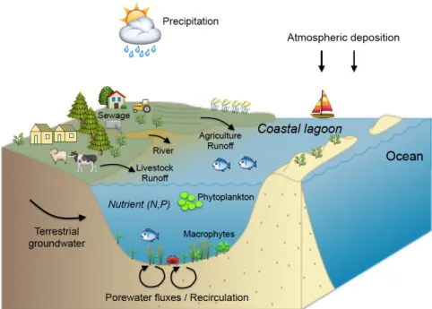
Over the past decades, groundwater discharge and porewater fluxes (recirculation), have been recognized as an important source of nutrient to coastal
ecosystems (Burnett et al. 2003; Slomp and Van Cappellen 2004; Kroeger et al. 2007). Inputs of nutrients associated with groundwater discharge and porewater fluxes can sometimes rival those fluxes supplied by rivers (Dorsett et al. 2011; Cyronak et al. 2013; Tovar-Sánchez et al. 2014). A considerable and a growing body of evidence suggests important ecological implications linked to groundwater discharge and porewater fluxes in coastal systems e.g. eutrophication, algal blooms, hypoxia events (e.g. Valiela et al. 1992; Wang et al. 2016). Most of these studies are based on indirect evidence, i.e. by measuring nutrient fluxes to coastal sites and subsequent inference that these nutrients are taken up by primary producers. Indeed, to date, only a comparatively small number of studies have directly addressed the transfer of dissolved nutrients originated from groundwater discharge and porewater fluxes into primary producers (Herrera-Silveira 1998; McClelland and Valiela 1998; Hwang et al. 2005).
The ecological implications of groundwater discharge to coastal ecosystems are not limited to nutrient loading, and thus primary production. In some regions with substantial groundwater loading, organisms may respond to changes in salinity, light penetration into water column, pH and turbulence (Short and Burdick 1996; Troccoli-Ghinaglia et al. 2010; Lee et al. 2017). Groundwater input has been demonstrated to increase meiofauna diversity in Olhos de Agua beach in Portugal (Encarnação et al. 2015) and enhance species richness, abundance and biomass of fishes and invertebrates in Japanese coastal waters, where high groundwater-borne nutrient concentrations have been reported (Hata et al. 2016; Utsunomiya et al. 2017). Despite these very few studies, there is limited information on the effects of groundwater discharge on animals at higher trophic levels such as oyster and mussels, particularly in coastal lagoons (Miller and Ullman 2004; Utsunomiya et al. 2017).
The ANR (French National Research Agency) @RAction chair MedLOC project “Rethinking Land-Ocean Connectivity – an Integrated Approach to Understanding the Effects of Groundwater on Coastal Ecosystems” (project leader T Stieglitz) aimed at closing the gap of fundamental understanding of the role groundwater flows play in the functioning and vulnerability of the French Mediterranean coastal lagoonal ecosystems. While a great amount of works has been and continuous to
be undertaken on many aspects of ecosystem functioning, anthropogenic and climate impacts on these French Mediterranean coastal lagoons, the role groundwater plays in the ecosystem functioning has not been investigated to date. Coastal lagoon ecology is traditionally biological disciplines, while groundwater studies are traditionally geological and hydrological disciplines. Hence, coupling hydrology and ecology crosses well established disciplinary borders, often resulting in studies lacking either the hydrological inputs or the ecological response (Zalewski 2002). Thus, there is a need to link physical and ecological processes in these coastal lagoonal ecosystems.
As part of this ANR project, my PhD research focuses on the ecological impacts of groundwater discharge in two French Mediterranean coastal lagoons (La Palme and Salses-Leucate lagoons). La Palme lagoon is a reference lagoon for the European Framework Directive for Water Quality Protection and Salses-Leucate lagoon is characterized by large groundwater inputs. The main objectives of this thesis were to:
i) Identify groundwater sources and quantification of groundwater-borne nutrients fluxes.
ii) Assess the role of groundwater discharge in supporting primary production in coastal lagoons.
iii) Quantify groundwater effects on the growth of Mediterranean mussels in a coastal lagoon.
To address these objectives, my PhD thesis is structured in 5 chapters:
Chapter 1 is an introduction to coastal lagoons, groundwater processes and the
study site. This chapter includes a detailed overview of coastal lagoons, including the definition, classification, and the ecological and biogeochemical characteristics of lagoons. A general description of terrestrial groundwater and porewater fluxes (recirculation), their quantification techniques, and their biogeochemical and ecological implications in coastal lagoons are presented. This chapter includes also a description of French Mediterranean coastal lagoons and the two studied lagoons: La Palme and Salses-Leucate lagoons.
In Chapter 2, groundwater-driven nutrient inputs to coastal lagoons are quantified, and the relevance of lagoon water recirculation as a conveyor of dissolved nutrients discussed. Nutrient fluxes driven by terrestrial groundwater discharge are contrasted against those of lagoon water recirculation through sediments, sewage input and other sources, using concurrent water and radon mass balances in La Palme lagoon. The recirculation through sediments is shown to be the main source of dissolved inorganic nitrogen and phosphorus to the lagoon. This study highlights the important role of groundwater processes as a major conveyor of dissolved nutrients to coastal lagoons and their possible ecological implications to lagoonal ecosystems. This chapter is published in:
(1) Valentí Rodellas, Thomas C Stieglitz, Aladin Andrisoa, Peter G Cook, Patrick Raimbault, Joseph J Tamborski, Pieter Van Beek, Olivier Radakovitch (2018). Groundwater-driven nutrient inputs to coastal lagoons: the relevance of lagoon water recirculation as a conveyor of dissolved nutrients. Science of the
Total Environment 642, 764-780.
In Chapter 3, the uptake of these nutrients delivered by groundwater discharge and porewater fluxes (recirculation) by primary producers is investigated using nitrogen (δ15N) and carbon isotopes signatures (δ13C). We demonstrate a direct
impact on lagoon ecological processes by documenting the transfer of groundwater and porewater derived nutrients into primary producers, thereby linking physical (nutrient delivery) and ecological (nutrient uptake) processes in
La Palme and Salses-Leucate lagoons. The δ15N signatures in primary producers
reflect predominantly the δ15N signatures of the terrestrial (karstic) groundwater
and porewater source, indicating the important role of these sources in fuelling primary production. The δ13C signatures also show the contribution of karstic
groundwater discharge and porewater fluxes as a significant source of dissolved inorganic carbon to primary producers. One publication related to this chapter is: (2) Aladin Andrisoa, Thomas C. Stieglitz, Valentí Rodellas, Patrick Raimbault.
Primary production in coastal lagoons supported by groundwater discharge and porewater fluxes inferred from nitrogen and carbon isotope signatures.
Marine Chemistry 210, 48-60.
In Chapter 4, the influence of fresh (terrestrial) groundwater discharge on the growth of the Mediterranean mussel Mytilus galloprovincialis in Salses-Leucate lagoon is investigated. Variations in growth rate and condition index (ratio between the tissue dry weight and shell weight) of mussels growing in and outside groundwater influence are examined, and the role of environmental parameters in mussel growth in this natural environment is investigated. Mussels from the groundwater-influenced sites have higher growth rate and condition index compared to those from the control site, as consequence of both the higher winter temperatures and the groundwater-driven nutrient supply that increase the food availability to support mussel growth. Importantly, growth rates from groundwater-influenced sites are amongst the highest rates recorded in the
(3) Aladin Andrisoa, Franck Lartaud, Ingrid Neveu, Valentí Rodellas, Thomas C. Stieglitz. Enhanced growth rates of the Mediterranean mussels in a coastal lagoon driven by groundwater inflow. Accepted in Frontiers in Marine Science, Special Issue ‘Submarine Groundwater Discharge: Impacts on Coastal Ecosystem by Hidden Water and Dissolved Materials’. In Chapter 5, the conclusions of this PhD thesis are summarized, and some future research perspectives are explored. Additional publications that this thesis is not directly based on but to which I have contributed as a co-author are:
(4) P G Cook, V Rodellas, A Andrisoa, TC Stieglitz (2018). Exchange across the sediment-water interface quantified from porewater radon profiles. Journal of
Hydrology 559, 873-883.
(5) Joseph Tamborski, Simon Bejannin, Jordi Garcia-Orellana, Marc Souhaut, Céline Charbonnier, Pierre Anschutz, Mireille Pujo-Pay, Pascal Conan, Olivier Crispi, Christophe Monnin, Thomas Stieglitz, Valentí Rodellas, Aladin Andrisoa, Christelle Claude, Pieter van Beek (2018). A comparison between water recirculation and terrestrially-driven dissolved silica fluxes to the Mediterranean Sea traced using radium isotopes. Geochimica et Cosmochimica
(6) Valentí Rodellas, Peter G. Cook, Aladin Andrisoa, Samuel Meulé, Thomas C. Stieglitz. Porewater fluxes into a coastal lagoon driven by wind waves and water level oscillations. Submitted in Journal of Hydrology. My contributions to the three papers forming a chapter in this thesis were: Chapter 2: Contributing to sample collection, sample analysis and the writing of the manuscript. Chapter 3: Contributing to the design of the study, leading the field investigations
in La Palme and Salses-Leucate lagoons and the sample analyses at the Mediterranean Institute of Oceanography (France), and taking the lead in writing the manuscript.
Chapter 4: Contributing to the design of the study, leading the field investigations
in Salses-Leucate lagoon and the sample analyses at the Observatoire Oceanologique de Banyuls-sur-Mer (France), co-supervision an M2 student and taking the lead in writing the manuscript.
1 Chapter 1: Introduction
– Chapter 1 –
Introduction
1.1 Coastal lagoons
1.1.1 General characteristics
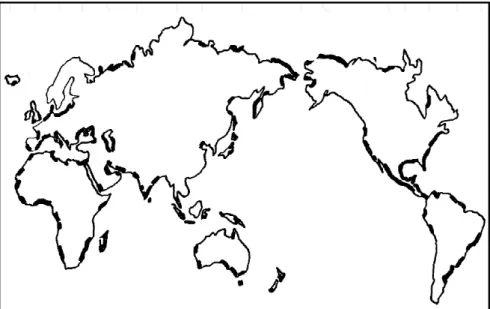
Coastal lagoons are shallow coastal water bodies separated from the ocean by a barrier, connected at least intermittently to the ocean by one or more restricted inlets (Kjerfve 1994). They are a particular type of estuary where seawater mixes with freshwater from their catchments (De Wit 2011). Coastal lagoons occupy about 13% of the world coastlines and are present on almost every continent (Fig. 1.1). They are most extensive along the African coast (17.9%) and the coasts of North America (17.6%), and less along the coasts of Asia (13.3%), South America (12.2%), Australia (11.4%), and Europe (5.3%) (Kennish and Paerl 2010). The most extensive stretch of coastal lagoons is along the Atlantic and Gulf coasts of the United States, covering 2800 km of shorelines (Miththapala 2013). Coastal lagoons can have different sizes ranging from 2 to 900.000 ha such as the Lagoa dos Patos in Brazil (Kennish and Paerl 2010). They differ significantly in hydrological and morphology characteristics.
Mediterranean coastal lagoons are relatively young ecosystems mostly formed during the Holocene (5000 - 1000 years ago) as a result of sea level rise (Cataudella et al. 2015). The Mediterranean region hosts around 400 coastal lagoons, covering a surface of about 641.000 ha (Kennish and Paerl 2010). For instance, in Italy alone, there are at least 194 coastal lagoons covering 168.000 ha. In France, there are 35 coastal lagoons, which cover a total surface area of 52.164 ha (Pérez-Ruzafa et al. 2011; IFREMER 2014). Mediterranean coastal lagoons greatly vary in size, ranging from 2 ha (e.g. the Chalikiopoulou lagoon, Greece) to 78 000 ha (Manzala lake, Egypt) (Cataudella et al. 2015). Like in many coastal areas, land use and land reclamation for agriculture, industry, and urban development have greatly contributed to the contraction of the overall coastal lagoon surface in Mediterranean region.
Figure 1.1| World distribution of coastal lagoons (De Wit 2011). Black areas represent coastal lagoons.
1.1.2 Classification
Coastal lagoons can be classified according to different parameters. A common classification is based on their salinity. Lagoons with salinities below 5 are oligohalines, mesohaline lagoons have salinity between 5 and 18, polyhaline lagoons have salinity ranging from 18 to 30 and lagoons with salinity above 30 are mixoeuhaline (De Wit 2011). However, several coastal lagoons exhibit considerable variations of salinity during the year, which may prevent their classification in one of these salinity-dependent categories.
Coastal lagoons can also be classified according their geomorphology and the water exchange with the coastal ocean (Fig. 1.2) (Kjerfve 1994; Kennish and Paerl 2010; Duck and da Silva 2012):
i) Choked lagoons
Choked lagoons usually have narrow channel connected to the ocean and are often located along coasts with high wave energy and important littoral drift (Niencheski et al. 2007; Bruno and Acha 2015). Although the lagoons may experience tidal fluctuations, the narrow channel inhibits the tide from entering the lagoon and prevents the variations of water level. Tidal fluctuations in choked lagoons are often reduced to 5% compared to adjacent coastal tide (Kjerfve 1994). Due to
limited exchange with the open ocean and high evaporation, choked lagoons in arid or semi-arid areas are often permanently or temporary hypersaline.
ii) Restricted lagoons
Restricted lagoons are connected to the ocean by multiple channels, which temporarily restrict the exchange between lagoon and ocean (e.g. Lakhdar et al. 2006). However, they usually have efficient water exchange and are generally influenced by tidal variations. Restricted coastal lagoons are often affected by winds and thus vertically well mixed. Salinity is highly variable ranging from brackish to saline water. The water residence time is usually shorter than in choked lagoons.
iii) Leaky lagoons
Leaky lagoons have wide channels to the open ocean, allowing water exchange between lagoon and the sea (Kjerfve 1994; Duck and da Silva 2012). They are often strongly influenced by tides and have salinity close to that of the adjacent sea. Figure 1.2| Geomorphic types of coastal lagoons (chocked, restricted and leaky) based on water exchange with the coastal ocean (Kjerfve 1994; Duck and Silva 2012). In this thesis, a choked (La Palme) and a restricted (Salses-Leucate) lagoons were studied.