Detrital Muscovite Thermochronology in Two Drainage Basins in Western Bhutan
by
Peldon Tshering
B. Eng. Civil and Environmental Engineering (1998) Cranfield University
Submitted to the Department of Earth, Atmospheric and Planetary Sciences in Partial Fulfillment of the Requirements for the Degree of Master of Science in Earth, Atmospheric and Planetary
Sciences at the
Massachusetts Institute of Technology January 2007
@2007 Peldon Tshering. All rights reserved.
The author hereby grants to MIT permission to reproduce and to distribute publicly paper and electronic copies of this thesis document in whole or in part in any medium now known or
hereafter created.
Signature of Author:
Department of Earth, Atmospheric and Planetary Sciences January 19, 2007 Certified by: Kip V. Hodges Professor of Geology Thesis Supervisor Accepted by: -Maria T. Zuber MASSACHUS-rS INSTrT'TWIE
OF TECHNOLOGY E.A. Griswold Professor of Geophysics
Head, Department of Earth, Atmospheric & Planetary Sciences I _ ! A r r A dLhflin I
BIL RARIES
Acknowledgement
This thesis and my studies here at the Massachusetts Institute of Technology have been possible because of the immense support that I have received from so many.
My gratitude to the Royal Government of Bhutan without whose financial support I would not have had the resources to pursue my graduate studies. It is only because of the importance the Royal Government attaches to education that I was able to pursue this opportunity. I would also like to thank the Honorable Deputy Minister of Environment, Dasho Nado Rinchhen for his understanding and support and all my colleagues at the National Environment Commission who have always encouraged me.
I am deeply indebted to my advisor, Professor Kip Hodges, for making it possible for me to be here at MIT under his supervision. For his complete support and overall guidance throughout my stay. I could not possibly have conceived or completed this thesis without his wide knowledge and comments, and his invaluable inputs.
I would also like to express my sincere thanks to:
Professor Michael Hawley, who first introduced me to MIT and made it possible for me to have had this incredible experience. For his support and friendship, and being an
Malcolm Pringle - for all the invaluable laboratory work that he put in for my thesis, his constant presence, stimulating discussions, and excellent teaching that helped me
understand so much more.
Katharine Huntingdon - for all her time and understanding and help with both studies as well as settling into a college life. Her unfailing patience, advice and help in innumerable ways have provided me with much encouragement in my work.
Will Ouimet - for the immense help with the GIS and other analysis that he provided.
All the professors and friends I have had the opportunity to associate with who have always extended a helping hand, taught me so many things and provided invaluable suggestions.
The fine staff here at the Earth, Atmospheric and Planetary Sciences department -my warm thanks for always having been so ready to help with any little problem and made life so much more pleasant.
My family - for having given me the strength and the encouragement in my studies. I would like to thank them for their sacrifices, unfailing support and their patience for seeing me through this long absence from home.
My daughter - who has had to put up with me through all the difficult times.
This opportunity has enabled me to fulfill a dream to undertake higher education where I have gained knowledge in a completely new subject that covers a most fascinating field. It has been a great privilege to know all the people mentioned above and the others I have met during this time. My sincere gratitude to all who have made this possible for me.
Detrital Muscovite Thermochronology in Two Drainage Basins in Western Bhutan
Sby
Peldon Tshering
Submitted to the Department of Earth, Atmospheric and Planetary Sciences on January 19, 2007 in Partial Fulfillment of the
Requirements for the Degree of Master of Science in Earth, Atmospheric and Planetary Sciences
Abstract
New reconnaissance data for a poorly characterized area in the western Bhutan Himalaya show distinction between the 40Ar/39Ar cooling age distributions of detrital minerals in the two river catchments of the Punatsang chu and the Wang chu. Muscovites from five
samples of Wang chu river sands yield ages (corresponding roughly to the time of bedrock cooling through a temperature of ca.350°C) between 9.37± 0.08 Ma and 13.98 ± 0.08 Ma. The
majority of ages are less than 13 Ma, and the data for all samples have a unimodal distribution with an average age of ca. 11.4 ± 1.5 Ma. In contrast, muscovites from 14 Punatsang chu
samples yield ages with nearly the same total range but with a distinctively multi-modal distribution. Two modes predominate in the Punatsang chu data: one at ca. 11.4 Ma, which is statistically indistinguishable from the single mode of the Wang chu data, and one at ca. 14.5 Ma.
The full explanation for this distribution must await further bedrock and detrital dating studies, but one hypothesis is that the out-of-sequence Kakhtang thrust fault system - which is thought to transect the upper reaches of the river catchments - has juxtaposed two bedrock terrains with different cooling histories. A second possibility is that the younger mode of cooling ages is related to uplift of the footwall of the Chomolhari fault system, which includes the major bounding structures of the Yadong-Gulu rift northwest of the catchments. Exactly why the older mode of ages is not found in the Wang chu dataset is unclear. If the first of the above hypotheses is correct, the lack of an older mode in the Wang chu dataset may mean that the muscovites in the Wang chu fluvial sediments were derived exclusively from the Kakhtang thrust system hanging wall. If the second hypothesis is correct, the muscovites may have been derived exclusively from the Chomolhari fault system footwall. However, since we do not know the actual distribution of muscovites in the Wang chu catchment and we do not know that modern erosion is uniform in the catchment, it is also possible that the older mode is simply missing as an artifact not-uniform sampling. Again, more studies are needed to evaluate these alternative explanations.
Thesis supervisor: Kip V. Hodges Title: Professor of Geology
Table of Contents
ACKNOW LEDGEM E NT ... 2
A B S T R A C T ... ... 4
C HAPTER 1: INTRO DUCTIO N ... .. 7
1.1 CONCEPTS OF THERMOCHRONOLOGY ... 8
1.2 G EOLOGIC SETTING ... ... 10
1.3 MOTIVATIONS FOR STUDY AND DEFINITION OF THE STUDY AREA ... 12
CHAPTER 2: APPROACH ... 15
2.1 SAMPLE COLLECTION ... ... 15
2.2 ANALYTICAL METHODS ... ... 16
2.2.1 Sample preparation and analysis ... ... 16
2.2.2 Assumptions in age calculations ... ... 19
2.3 STATISTICAL ANALYSES... ... 20
2.3. 1 Synoptic probability density function ... 20
2.3.2. Estimating erosion rates... 21
CHAPTER 3: RESULTS AND OBSERVATIONS ... 22
3.1 W ANG CHU DATA ... 22
3.2 PUNATSANG CHU DATA ... .. 22
4.1 PRECIPITATION AND CHANNEL MORPHOLOGY ... 25
4.2 NON-UNIFORM DISTRIBUTION OF MUSCOVITE ... 26
4.3 POSSIBLE CAUSES FOR THE YOUNG AGE MODE ... 27
4.3. 1 Exhumation of the STF Footwall ... 28
4.3.2 Uplift of the Eastern Flank of the Yadong-Gulu Rift... 29
4.3.3 Hanging Wall Uplift of the Kakhtang Thrust System... 30
CHAPTER 5: CONCLUSIONS ... 31
R E F E R E N C E S ... 34
FIG U R E C A PT IO N S ... ... 39 A P P E N D IC ES ... ... 4 1
CHAPTER 1: Introduction
Detrital mineral thermochronology is a powerful way to determine the
temperature-time history and erosion rates of catchments in active orogens (Hodges, 2003; Reiners et al., 2005). Although several geochronometers have been applied to detrital samples, the 40Ar/39Ar technique is, at present, the most precise and accurate
tool for the study of late Cenozoic samples (Ivanov et al., 2002).
This thesis is the result of an application of the 40Ar/39Ar dating method to infer
cooling ages to the source regions of the detrital mineral samples from two river
catchments in Bhutan. Ultimately, my intention was to explore the exhumation history of these areas with an eye toward understanding the impact of various known
deformational structures on that history.
Bhutan is a small kingdom located between longitude 88g45' and 92°10 ' E and
latitudes 26-40' and 28015' N in the Eastern Himalaya, one of the least well-known segments of the Himalayan-Tibetan orogenic system. Bounded by India to the south and the Tibetan Autonomous Region of China to the North, the country displays a range of elevations from 100m along the Indian border to the 7,554m Kula Gangri peak on the Tibetan border. These two extremes frame a landscape which stretches from sub-tropical to alpine conditions over a lateral distance of only about 150 km.
1.1 Concepts of thermochronology
Many minerals contain elements that have one or more radioactive isotopes. Geochronology is based on the fact that the natural radioactive decay of these "parent"
isotopes to radiogenic "daughter" isotopes occurs at constant rates over geologic time, such that measurements of the relative amounts of parent and daughter isotopes can be used to calculate a "date" (Faure, 1986). If the mineral is a closed system with respect to the gain or loss of parent or daughter isotope, the date that is calculated can be interpreted as the crystallization age of the mineral. However, many radiogenic daughter isotopes diffuse relatively rapidly out of the mineral structure at elevated temperatures, such that the radiometric "clock" does not start until the mineral cools below some threshold temperature range when it becomes an effectively closed system. Since diffusion rate is strongly temperature dependent, this temperature range is relatively narrow and it has become common practice to refer simply to the "closure temperature" of a mineral-isotopic system (Dodson, 1973).
Dodson's formula to calculate the bulk closure temperature (Tcb) of a crystal can be represented as:
E
R1n(eGavRDTc/ a2 E(dT/dt))
where E is activation energy of the process, R is the gas constant, Di is the diffusivity at infinite temperature, a is the diffusion dimension (often assumed to be half of the crystal's physical grain size), and dT/dt is the cooling rate (Hodges, 2003). In this equation, Gav is dependent on the assumed geometry of diffusion: 4.00660 for radial
diffusion in a sphere, 3.29506 for radial diffusion in a cylinder, and 2.15821 for diffusion across a plane sheet (Dodson, 1986; Hodges, 2003).
With time, rocks from depth are brought upward towards the surface as a result of erosion or tectonic unroofing of the overlying material. Since temperature is known to increase with depth in the continental crust, the mineral grains pass through their closure temperatures and cooling ages are recorded to reflect the change in the rock's position in time with respect to the surface (Huntington and Hodges, 2006; Braun et at., 2006). The ability to date cooling through a specific closure temperature allows the reconstruction of the cooling history of the unit, since different mineral-isotopic systems have different closure temperatures (Stuart, 2002).
Although most thermochronologic studies focus on bedrock cooling ages, the research described here focused on detrital mineral grains in modern river sediments. Detrital mineral thermochronology has become a popular way to explore both the general exhumation history of the exposed bedrock within a river's catchment area and, where this history is known relatively well a priori, to establish variations in erosion rate within a catchment. One of the most effective tools for such studies is the
40Ar/39
Ar muscovite thermochronometer, which yields ages corresponding to the timing of latest cooling of detrital muscovite grains through Tcb of ca.3500C (Hodges, 2003; Hodges et al., 2005). Muscovites are relatively resistant to grain-size diminution and alteration during erosion and transport. They are preferable to biotites or phlogopites which frequently contain excess 40Ar, are more susceptible to alteration, and often form
The 40Ar/39Ar method itself is a variant of the K-Ar technique, which is predicated on the natural decay of 40K to 40Ar. In 40Ar/39Ar dating, samples are irradiated with fast
neutrons to stimulate the formation of synthetic 39Ar by a neutron-capture,
proton-emission reaction:
39K + n-Y Ar + P
19 18
The abundance of 39Ar produced in this way is proportional to the abundance of 3 9K in the sample, so that it is possible to calculate the equivalent of a K-Ar age from a
measurement of the 40Ar/39Ar ratio in evolved Ar from an irradiated sample. Additional
details of this technique can be found in McDougall and Harrison (1988).
1.2 Geologic Setting
As noted by Hodges (2000), the geology of the Himalaya is often described in terms of tectonostratigraphic packages separated by major fault systems. In Bhutan, all of the major tectonostratigraphic packages have been identified, as have the faults separating them. Bhutan is bounded on its northern border by the north-dipping, east-striking, low-angle brittle normal faults of the South Tibetan Fault (STF) system (Burchfiel et al, 1992; Hodges, et al.,1998; Hodges, 2000; Daniel et al., 2003). Farther south lies a series of subparallel, generally east-striking, north-dipping thrust fault systems: the Main Central Thrust (MCT), Main Boundary Thrust (MBT) and the Main Frontal Thrust (MFT) systems. Another major thrust system in Bhutan, interpreted as an out-of-sequence feature lying between the STF and MCT systems, is the Kakhtang
Thrust (KT) system. It is believed to postdate both the STF and the MCT systems (Gansser, 1983; Grujic et al., 1996; Hollister and Grujic, 2006).
In the northern part of Bhutan, the predominant rock types are weakly metamorphosed (greenschist facies) units of the Tibetan Sedimentary Sequence. They are separated from underlying high-grade (amphibolite facies) metasedimentary rocks of the Greater Himalayan Sequence (GHS) by structures of the STF system. South of their main outcrop belt, Tibetan sequence rocks also occur as klippen overlying GHS units in the Lingzhi and Tang chu basins (Gansser, 1983; Grujic, 2002). GHS schists and gneisses dominate a major part of the geology of Bhutan. Two major units have been identified within this sequence: orthogneisses of the Thimphu Formation and metacarbonates, amphibolites, and schists the Paro Formation (Gansser, 1 983;Tobgay, 2005). The Paro Formation also hosts large volumes of leucogranite which are interpreted as locally derived anatecic melts.
Structurally beneath the GHS - and separated from it by the MCT system - lies
the Lesser Himalayan Sequence (LHS). As described by Gansser (1983) and Tobgay (2005), it includes low-grade to unmetamorphosed metasedimentary rocks of the Jaishidanda Formation (mainly garnetiferous schists), the Shumar Formation (interlayered quartzites and chloritic schists), and the Buxa Formation (mainly metacarbonate rocks). The lower boundary of the LHS corresponds to the MBT system of faults. Across that boundary, the Subhimalayan Zone of Hodges (2000) includes sedimentary rocks of the Siwalik molasse. At the margin of the Gangetic foreland basin
farther south, these molasse deposits are thrust over the foreland deposits along the
MFT system.
Five east-west trending physiographic transitions- PT1, PT 2a, PT2b, PT2c and PT 3 and a north-south physiographic transition, PT4, have been identified in Bhutan (Tobgay, 2005). PT1 is said to be the delineation between the main Himalayan ranges and the Tibetan Plateau, and PT2, occurring south of the range crest is described as a separation of the southern slopes of the high peaks from the lower foothill regions (cf.,
Hodges, 2001). In Bhutan, divisions of PT2 occur as PT2a, PT2b and PT2c based on changes in stream morphology (Tobgay, 2005). PT 3 separates the Himalayan foothills from the foreland basin near the Indian border. Eastern and western Bhutan are separated by another physiographic transition (PT4). As initially suggested by Hodges et al. (2001) for the central Himalaya, PT1 and PT3 in the Bhutan Himalaya may correspond to active traces of the STF and MFT systems. Tobgay (2005) suggested that PT2a, PT2b and PT2c, as well as PT4, may also correspond to active fault traces, though these transitions have not been studied in detail.
1.3 Motivations for Study and Definition of the Study Area
Compared to other Himalayan nations, the geology of Bhutan is less well known. Although numerous 40Ar/39Ar studies have been undertaken elsewhere in the Himalaya
in order to constrain erosional histories, no systematic studies have been done in Bhutan and only a very few 40Ar/39Ar ages have been published at all for the kingdom
(e.g., StOwe and Foster, 1991). The present reconnaissance study was designed to improve our basic knowledge of the thermal evolution of the Bhutan Himalaya by concentrating on detrital muscovites collected from two major river systems in northwestern Bhutan. The data presented here constitute the first steps toward constraining erosional and bedrock uplift histories in this region.
The two rivers studied are the Wang chu and the Punatsang chu. Sediments collected from the Wang chu catchment represent the Thimphu dzogkhag (district), while the Punatsang chu samples were eroded mainly from three dzongkhags: Gasa, Punakha and Wangdi Phodrang. Both rivers have their sources in the high mountainous regions of Bhutan and some of their tributaries are fed by glacial lakes. Both rivers flow south to join the Brahmaputra in India. Baillie and Norbu (2002) described the dissection histories and longitudinal profiles of these rivers. Thimphu valley is at a much higher elevation than the Punakha valley at 2,200 meters above sea level. The temperatures in Thimphu range from approximately 150 C to 260 C during the summer monsoon season
of June through September, but drop to between about -41 C and 160 C in winter.
Thimphu experiences dry winter months and wet summers due to the monsoons. Punakha, on the other hand, is at a lower elevation (approximately 1300m) with an almost subtropical climate of hot summers - temperatures ranging between 220C to
320C - and pleasant winters with temperatures between 40C to 150 C.
The catchment area above the sampling points on the Wang chu is considerably smaller than that of the Punatsang chu above its sampling points. The Wang chu
includes drainage from the Lingzhi basin down through the Thimphu valley, and the main trunk stream is joined by only a few minor tributaries along that reach. In contrast, the lower Punatsang chu trunk stream is formed by the confluence of two major rivers, the Pho chu and the Mo chu, just below Punakha dzong. Further downstream, another tributary, the Dang chu, makes a major contribution to the Punatsang chu outflow. The Mo chu tributary drains the high peaks of Masagang as well as the Lingzhi basin, while the Pho chu drains the Lunana basin and other areas of northeastern Bhutan. The Dang chu drains the large glacial valley of Phobjikha down through the Wangdi Phodrang
dzongkhag.
In 1994, glacial lake Lugge tso experienced an outburst event that released 20x106 m3 of water down the Pho chu channel (Watanabe and Rotacher,1994). Many more glacial lakes occur in this region and there is evidence for frequent outbursts of their restraining dams (landslides and moraines) in the past. As a consequence, there has been increased interest in learning more about the geologic hazards of this remote region in recent years.
CHAPTER 2: Approach
2.1 Sample collection
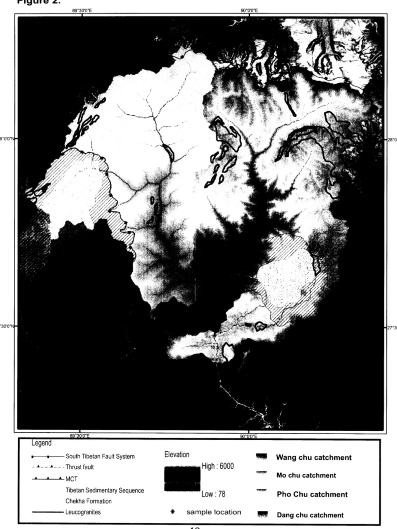
Sample collection along the catchments were carried out in November 2005. Most of the locations are fairly close to the motorable roads. Samples were collected from either side of the river banks depending on accessibility. Two to four handsful of sand were collected at each sampling point. The locations of sampling locations were determined by handheld GPS receivers and are mapped in Figure 2.
The Wang chu forms a relatively narrow valley and its bed is confined by steep walls. Five samples were collected from the Wang chu from a point about 50 meters above the Chari Monastery foot bridge to a point just upstream of the confluence of the Wang chu with the Pa chu. The four sampling points to the north (WC-1 through WC-4) lie between the STF and Physiographic Transition 2a. The southernmost point (WC-5) lies between PT2a and PT2b. The catchment above this sampling point has a total area of approximately 992 km2 , with elevations ranging from 2330 m to 5768 m. The Wang
chu samples were noted to have a larger number of biotites than muscovites, and the river sands contained many small red crystals of garnet.
Fourteen samples were collected in the Punatsang chu drainage between PT2a and PT2b. The entire catchment area above the same, collected farthest downstream
samples (PC-1 through PC-5) were taken from the Mo chu drainage above its confluence with the Pho chu. Seven (PC-6 through PC-12) were taken from the Punatsang chu trunk stream between the Mo chu-Pho chu confluence and the mouth of the Dang chu tributary. Finally, two samples (PC-13 and PC-14) were collected below the Punatsang chu-Dang chu confluence.
Most of the sampled reach flows through a broad, largely alluviated valley. Widespread sand deposits along some segments of the Mo chu and Punatsang chu imply past landslide damming and subsequent outbursts. Some segments, on the other hand, were almost free of riverbank sand and the principal shoreline alluvium was a mixture of cobbles and fine silt. In these cases, sand for analysis was collected underwater, directly from the active river bed. The Punatsang chu samples were found to contain considerably greater concentrations of muscovites than the Wang chu samples.
2.2 Analytical methods
2.2.1 Sample preparation and analysis
The samples were washed, cleaned of debris, and sieved to between 500 and 1000 microns. Smaller grain sizes were discarded because of the potential health hazard of working with fine-grained radioactive samples and because grains sizes of < 0.2 mm may loose 39Ar though recoil during irradiation (Hodges et al., 2005). Larger
sizes may also hamper analyses by resisting homogeneous heating to give erroneous results (Vasconcelos et al, 2002). The retained sand grains were washed again in water and dried. Muscovites were separated from other unwanted minerals by paper shaking. The mica was then washed in acetone, ethanol and distilled water. Vermeesh (2004) proposed that, in order to achieve a required level of statistical adequacy of 95% confidence level to include at least 95% of the total population of the sample, at least 117 grains should be dated from a detrital sample. In light of this, I picked about 150 to 200 muscovite grains from each sand sample under a binocular. These picked grains were packed into aluminum foil packets and loaded into fused silica vials for irradiation.
The samples were irradiated at the McMaster University Nuclear Reactor in Canada for 6 hours at a power level of 3 MW in the C5 position. Afterwards, the samples were unpackaged and individual micas were loaded into 2 mm diameter, 3 mm deep holes on a 100-hole Cu planchette in the Massachusetts Institute of Technology (MIT) noble gas laboratory. The planchette was then loaded into a UHV sample chamber with a glass view-port, and baked out at ca. 3200 C for 8 hours in preparation for analysis.
Noble gasses were extracted from each grain by single-step melting with a laser. Detrital mineral 40Ar/39Ar studies sometimes employ a multi-step, incremental heating
protocol for gas extraction, principally to minimize the impact of alteration and excess
40Ar contamination. However, previous studies of muscovites from bedrock studies
or excessive alteration and we simply liberated all noble gasses in one fusion step, thereby substantially decreasing the duration of each experiment. For this study, each crystal was heated with an 810 nm diode laser beam focused to a ca. 1.5 mm spot size, ramping from 0 to 15 W over two minutes and then held at 15W for 15 seconds. The slow heating rate and defocused laser beam minimizes the amount of crystal movement during heating, a problem encountered probably significantly more than is typically reported for automated mica laser fusion studies. With the laser protocol adopted here, muscovite typically begins to fuse at 4 W, and complete fusion to a refractory glass ball nearly always occurs. Note that mica crystals were not degassed with the laser beam before analysis as is often the case with CO2 laser-based detrital mica studies. We feel
that the significantly higher bake out temperatures possible with glass compared to special mid-infrared view-ports necessary for the CO02 laser significantly reduces the need for such a cleaning step. The results presented here support that assertion- only 3 of the 1039 muscovite analyses reported below had radiogenic 40Ar contents less than 40%, and fully 95% of the analyses had radiogenic 40Ar contents over 78%.
After fusion, the released gases were purified for 10 minutes with a SAES glass-encased 10 I/sec St101 getter operated at ca. 650 deg, and a second, all metal, SAES 50 I/sec St101 getter operated ca. 3500C. The purified gases were then admitted to an MAP 215-50 mass spectrometer for Ar isotopic analysis using a Johnson MM-1 electronic multiplier operated at a gain of about 10,000.
The conversion efficiency of 39K to 39Ar was monitored using sanidine from the
Taylor Creek rhyolite (TCR-2a) assuming an age of 28.34 Ma (Renne et al., 1998), and is known to better than 0.2 % (2a). Corrections for neutron-induced interferences, previously determined for this reactor facility using Fe-doped kalsilite glass and optical CaF2, were 0.025 for 40Ar/39ArK, 0.000672 for 39Ar/37Arca, and 0.00028 for 36Ar/37Arca.
Final data reduction was conducted with the program ArArCalc version 2 (Koppers, 2002). The output of this measurement for all samples is attached in Appendix 1 and 2.
2.2.2 Assumptions in age calculations
McDougal and Harrison (1998) and Hodges (2003) have emphasized some primary assumptions that need to be fulfilled in order to constrain geologically meaningful detrital mineral cooling ages from the quantitative estimates of closure temperatures. These may be summarized as follows:
1) The decay rate of the parent nuclide, 40K must be independent of its
physical state and is not affected by differences in pressure or temperature. 2) The 40 K/39K ratio in nature remains constant. This is because 40K is not
measured directly. In the 40Ar/39Ar technique, it is derived from the measured 39Ar
3) All radiogenic argon measured in the sample comes from the decay of the
40K since time of crystallization, and no gain or loss of parent or daughter
isotopes have occurred since this closure.
4) The isotopic composition of atmospheric argon 40Ar/36Ar ratio = 295.5, as
measured by Nier (1950), such that measured 40Ar can be corrected for its
non-radiogenic "atmospheric" component.
5) Volume diffusion is the principle mode of daughter isotope loss.
2.3 Statistical analyses
2.3.1 Synoptic probability density function
To allow comparison, the cooling age signal from the ArArCALC data for each
grain, comprising the calculated age tm and the analytical uncertainty in that age "'- is
defined as a probability density function (PDF) of age (t). The PDF is calculated (Silverman,1986; Ruhl and Hodges, 2005) as follows:
1
2 at Me
PDF= O am
Where "'- is the calculated uncertainty in that age, tm is the calculated age.
The distribution of probability as a function of apparent age within the sample of
the area under the curve normalized to one. This gives the synoptic probability density function (SPDF):
In
S• •PDF(i)
SPDF = n =
A final plot is made using the apparent cooling age with lo uncertainty and assuming a Gaussian distribution for each analysis ( Figure 3 and Figure 4).
2.3.2. Estimating erosion rates
Ruhl and Hodges (2005) demonstrated how detrital thermochronologic data can be used to constrain catchment-wide bedrock erosion rates assuming steady-state topography and uniform erosion. The method involves comparing a non-dimensionalized hypsometric curve for the catchment region above the sampling point to a non-dimensionalized Cumulative SPDF curve for the sample. If steady-state and uniform erosion conditions are met, these two curves should have the same form and the erosion rate can be estimated simply as the catchment relief divided by the detrital mineral cooling age range.
CHAPTER 3: Results and Observations
Although the Wang chu and Punatsang chu are not very far apart, the detrital muscovite 40Ar/39Ar ages for the two drainage systems have very different frequency
distributions.
3.1 Wang chu Data
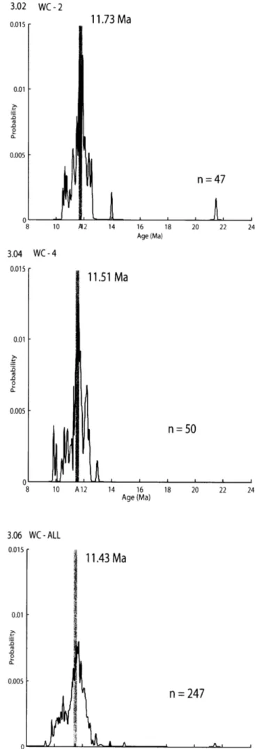
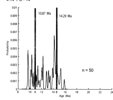
Figure 3 shows the 40Ar/39Ar cooling age synoptic probability density function
plots for each Wang chu sample. All show essentially the same unimodal pattern with means between ca.10.6 ± 1.2 Ma to ca.11.7 ± 1.4 Ma (Table 1). Most of the 247 analyzed grains yield ages between 13.98 ± 0.08 Ma and 9.37 ± 0.08 Ma, but two
outliers were identified: a 21 Ma grain in WC-2 and a 15 Ma grain in WC-5. It is not possible to ascertain whether these anomalous ages reflect true heterogeneity or imply either excess 40Ar or sample contamination, but the paucity of such older ages in the
dataset led me to disregard these values in subsequent data interpretation. When these outliers are excluded, the Wang chu dates collectively yield a mean age of ca.11.4 ± 1.5 Ma.
3.2 Punatsang chu Data
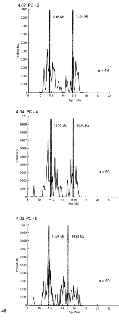
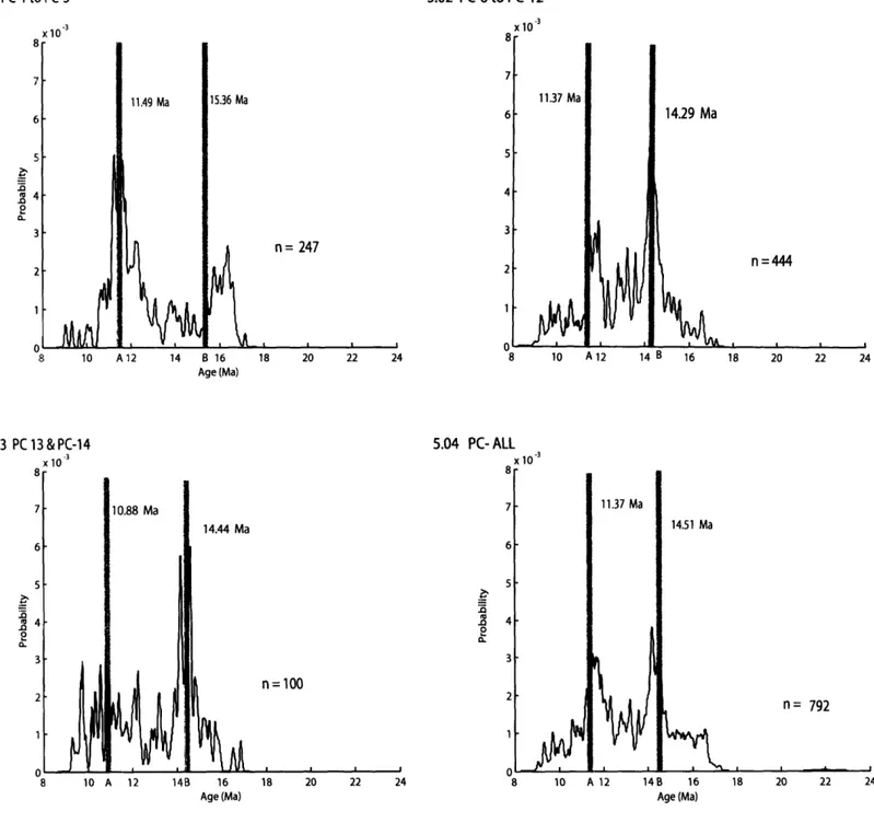
In general, the 40Ar/39Ar age probability density functions for the Punatsang chu
muscovites in samples collected above the Mo chu-Po chu confluence range from 17.16
± 0.09 Ma to 9.03 ± 0.08 Ma, with one ca. 22 Ma outlier detected in PC-1. Unlike all Wang chu samples, these five samples yielded distinctively multi-modal SPDFs. The seven samples collected between the Mo chu-Po chu confluence and the Punatsang chu-Dang chu confluence yielded similar results, with ages ranging from 17.25 ± 0.09
Ma to 9.04 ± 0.17 Ma. Finally, the southernmost samples (PC-13 and PC-14) had ages ranging from 16.85 ± 0.10 Ma to 9.29 a 0.10 Ma.
Although the datasets for all three reaches along this drainage differed in detail, all fourteen samples collectively yield a multimodal SPDF with two predominate age
modes. I used a program developed by Jose M. Hurtado, Jr to implement the
multicomponent analysis as described in Sambridge and Compston, (1994) in order to better quantify these modes as having ages of ca. 11.4 Ma and ca. 14.5 Ma (Figure 5). The dominant mode in the PC-1 through PC-5 samples is statistically indistinguishable from the weighted mean age of samples from the Wang chu drainage. However, samples collected farther downstream display an increasing contribution from the older (ca. 14.5 Ma) mode. This systematic variation is illustrated in Figure 5. The simplest interpretation of these results is that the Po chu tributary, in particular, contributes many of the older age muscovites identified in this study.
Chapter 4. Data Analysis and Interpretation
The Wang chu data are relatively straightforward, and the unimodal nature of the
SPDFs for these samples encouraged me to try using the approach described by Ruhl and Hodges (2005) to extract catchment-wide erosion rates from the data. Unfortunately, non-dimensionalized hypsometric curves and cumulative probability density curves for the muscovite ages showed very different morphologies (Figure 6), suggesting that one or more of the assumptions critical to the technique was incorrect. The multimodal nature of the Punatsang chu data suggested that these samples were also unlikely to be useful for erosion rate estimates, and a rigorous application of the approach of Ruhl and Hodges (2005) indicated that this was indeed correct.
Even though the Wang chu and Punatsang chu data are not useful for explicit erosion rate estimates, they indicate relatively rapid uplift of bedrock through the ca. 3500C closure isotherm for 40Ar/39Ar muscovite in Miocene time. In general, the detrital
mineral age ranges obtained for the Bhutan samples are substantially older than those obtained in other studies from rivers in central Nepal (Wobus et al., 2003; Ruhl and
Hodges, 2005; Wobus et al., 2006). This implies a late Miocene-Pliocene rejuvenation of exhumation of the Greater Himalayan Sequence in central Nepal that apparently did not occur in western Bhutan. The single Wang chu mode of ages, as well as the young Punatsang chu mode, are comparable to two of the four 40Ar/39Ar bedrock muscovite
eastern Bhutan: 11.6 and 11.3 Ma. (The other two muscovite ages reported by those authors were c. 14 and 14.7 Ma.) However, the distinction between the detrital mineral age signals in two adjacent drainage basins in western Bhutan requires further explanation. In the following paragraphs, I explore some of the potential causes.
4.1 Precipitation and Channel Morphology
One possibility for the discrepancy is that modern erosion rates are substantially different in the two catchments and perhaps distinctive in the different sub catchments studied in the Punatsang chu basin. The two principal drivers for erosion are precipitation and bedrock uplift, so we can explore this possibility by examining precipitation patterns and channel morphology (as a proxy for bedrock uplift rate; Kirby et al., 2003).
Most precipitation in the region of interest in Bhutan comes in the form of monsoon rain. Mean annual precipitation varies from ca. 4.5 m/year at the southern front to ca. 0.6 m/year around the northwestern parts of Bhutan (9 to 15 years data obtained from the Metrology. Dept. of Bhutan). At lower elevations, the two catchments receive similar rainfall each year. However, higher elevations of the Punatsang chu catchment receive an average of 1.1 m/yr as opposed to 0.8 m/yr at similar elevations in the Wang chu catchment. It is plausible, therefore, that the presence of older ages in the Punatsang chu dataset may partially reflect higher erosion rates at higher elevations (which would, in principle, yield older ages).
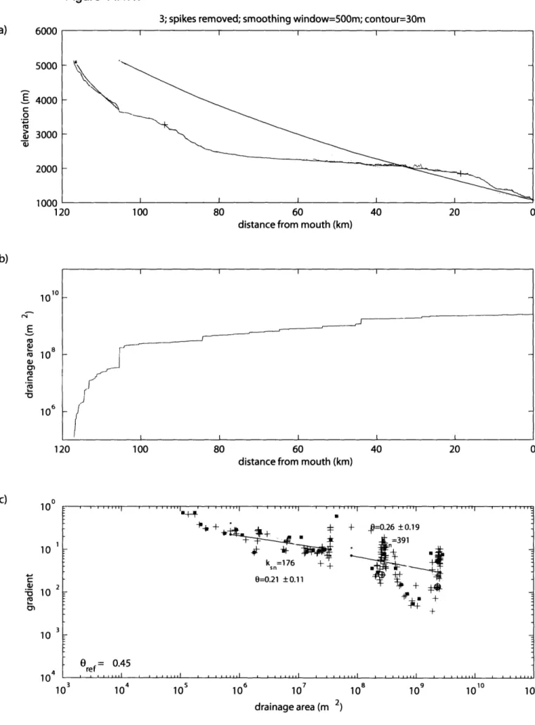
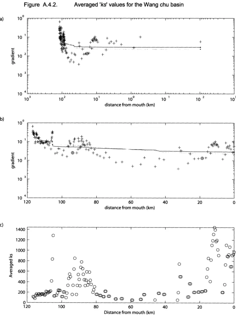
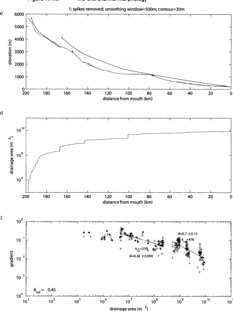
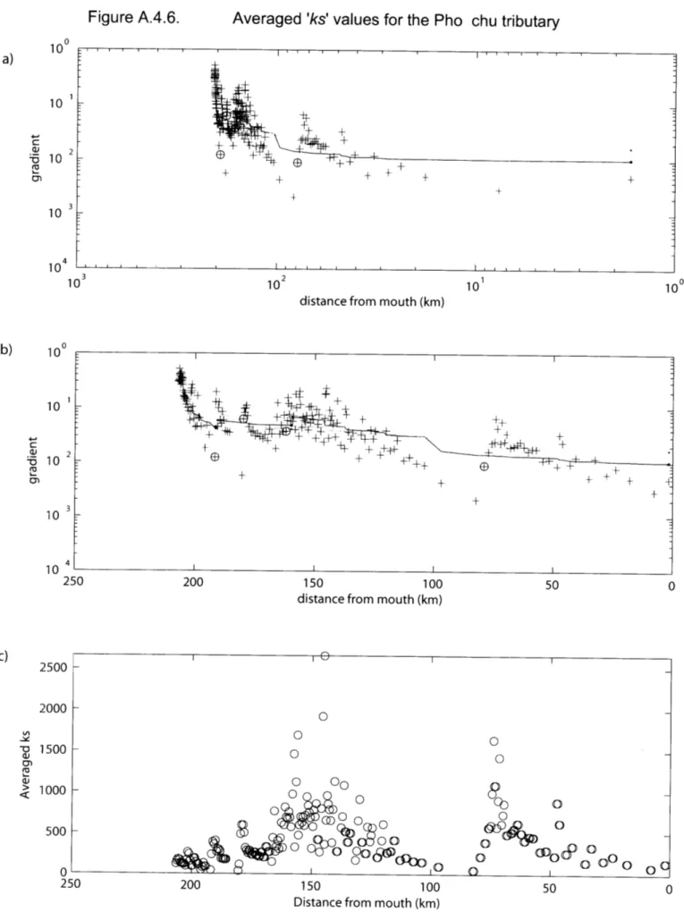
Since river channel steepness is thought to correlate with rock uplift rate in many instances (Kirby et al., 2003; Hodges et al, 2004), I compared the channel steepness indices for 89 individual streams in northwestern part of Bhutan. A normalized channel steepness index (CSI) was calculated from the regression intercept 'ks 'for all channels using a fixed concavity (regression slope (0)) = -0.45, which effectively removes the dependence on profile concavity and enable comparison of channel steepness (Kirby et al, 2003).
In general, the Wang chu, has very few areas of high CSI values and generally remains at relatively lower steepness values for most of its length. On the other hand, the Pho chu and the Mo chu both are characterized by steep main channels and relatively lower tributary CSI. In the far northern reaches of these drainages, the CSI
values are low, probably due to glaciations. (In glaciated regions, the relationship between channel steepness and rock uplift rate no longer holds). Again, this exercise suggests that some of the older age signal from the Punatsang chu drainage may reflect higher erosion rates at high elevations.
4.2 Non-Uniform Distribution of Muscovite
A second plausible reason for the difference in muscovite cooling age distributions in the two catchments is that muscovite is non-uniformly distributed in the Wang chu basin. If, for example, the bedrock in the upper parts of the catchment
contained little or no muscovite, downstream sediments may contain none of the ca. 14.5 Ma signal that is so dominant in the Punatsang chu data.
Unfortunately, there has not been much bedrock mapping in the study area in recent years and it is not clear from previous descriptions of the lithologies in the area (mainly from Gansser, 1983 and 1964) whether or not muscovite is a common mineral in the upper Wang chu catchment. It is perhaps noteworthy that the uppermost parts of the catchment drain lower Paleozoic Tibetan Sedimentary Sequence hanging wall units of the STF system according to existing maps (Gansser, 1983). Elsewhere in the Himalaya, these rocks are predominately unmetamorphosed and contain little muscovite (Gaetani and Garzanti, 1991). Clearly, more bedrock mapping and thermochronology studies are needed in this part of Bhutan.
4.3 Possible Causes for the Young Age Mode
If the narrow range of muscovite ages in the Wang chu sediments does not reflect localized (rather than catchment-wide) erosion and there is, in fact, a more-or-less uniform distribution of muscovites in the catchment, then bedrock in the catchment over an elevation range of more than 3 kilometers cooled through the ca. 3500C isotherm in less than four million years. The simplest explanation for this is a rapid exhumation event in Middle to Late Miocene (Serravallian-Tortonian) time. If this interpretation is correct, the prominence of the same young age mode in the Mo chu muscovites implies that the same event also affected the upper reaches of the Punatsang chu catchment. Below I discuss three possible tectonic scenarios that might result in accelerated exhumation during the Middle to Late Miocene time frame.
4.3.1 Exhumation of the STF Footwall
The upper Wang chu and Mo chu catchments include substantial bedrock terrain that lies in the footwall of the South Tibetan fault system. Generally speaking, for a region that erodes uniformly during more or less vertical uplift, detrital muscovites eroded from rocks at
higher elevations should be older than those eroded from rocks at lower elevations. However, tectonic denudation by slip on rooted detachments can lead to a younging of footwall cooling ages toward the detachment surface (Stockli, 2005). In the study area, this might be manifested as a narrow range of Serravallian-Tortonian muscovite ages preferentially sampled from the STF footwall. If this hypothesis is correct, the age of major STF slip in the study region should be Middle-Late Miocene.
Unfortunately, there are no direct constraints on the age of STF slip in northwestern Bhutan. The closest such constraints come from the Khula Kangri area of Tibet, north of eastern Bhutan (Edwards and Harrison, 1997). Edwards and Harrison presented ca. 12.5 Ma Th-Pb dates for monazites from a granite in that area, suggesting STF slip at sometime shortly after that date. Both the weighted-mean cooling ages for the Wang chu detrital muscovites and the young mode for the Punatsang chu detrital muscovites are consistent with the interpretation that slip on the STF system was responsible for rapid exhumation of the Wang chu and Mo chu headwaters.
4.3.2 Uplift of the Eastern Flank of the Yadong-Gulu Rift
The headwaters of the Wang chu and the Mo chu tributary of the Punatsang chu also lie within a mountain range that forms the southeastern boundary of a segment of the longest rift system in southern Tibet, the N30'E-trending Yadong-Gulu rift (Armijo et al., 1986; Wu et al, 1998). The northwestern front of this range is marked by west-dipping, en echelon, normal and right-lateral structures of the Chomolhari fault zone (or "Yadong cross structure"). According to Wu et al. (1998) and Cogan et al. (1998),
cumulative slip on the Yadong cross structure resulted in a ca. 70 km right-lateral offset of the Himalayan range crest and the STF system. More recently, Hodges (2006) has suggested that the Chomolhari fault zone may instead be a tear fault in the STF system.
In any case, the elevation difference between the rift valley and the southeastern rift flank implies substantial rift flank uplift along the Chomolhari fault zone, and it is
possible that the young muscovite ages that dominate the Wang chu sediment samples
- as well as samples from the upper Mo chu catchment (PC-1 through PC-5) - reflect
rift flank uplift in Serravallian-Tortonian time.
Although the Chomolhari fault zone is seismically active today, there are no independent constraints on the initiation age of the fault zone that might help test the hypothesis that early slip on it is responsible for the young muscovite ages. Wu et al. (1998) argued that the Yadong cross structure offset the STF system in such a way that different down-dip sections of the STF system were exposed at the surface west and east of the cross structure. Based on the Edwards and Harrison (1997) work in the
Khula Kangri area, the Yadong cross structure must have initiated sometime after 12.5 Ma. Edwards and Harrison themselves suggested an initiation age of 10-8 Ma for the Yadong cross structure, but that interpretation was based largely on assumptions regarding a relationship between rifting in southern Tibet and 10-8 Ma gravitational collapse of the Tibetan Plateau (Harrison et al, 1992). If they are correct, rift flank uplift on the Chomolhari fault zone would have been too young to explain the Serravallian-Tortonian detrital muscovite ages, but the lack of firm independent constraints on the initiation age permits rift-flank uplift to remain a viable explanation until further work is done.
4.3.3 Hanging Wall Uplift of the Kakhtang Thrust System
A final hypothesis derives from the interpretation by Grujic et al. (2002) that the out-of-sequence Kakhtang thrust system was active over the 14 -10 Ma age range in Bhutan. This range is consistent with the idea that hanging wall uplift on these structures may have forced focused erosion in northern Bhutan during the Serravallian-Tortonian interval. This hypothesis is difficult to test because the Kakhtang thrust system has been identified and mapped thus far only in eastern Bhutan and not in my study area. Future work, may help evaluate the role of the Kakhtang thrust system in
CHAPTER 5: Conclusions
Detrital muscovites collected from two major river systems in western Bhutan yield Early to Late Miocene 40Ar/39Ar cooling ages. With the exception of two outliers thought to be without geologic significance, all single-grain muscovite ages from Wang chu sediment samples range between ca. 9.37±0.08 Ma and ca.13.98 _ 0.08 Ma, and individual sand samples yield mean muscovite ages between ca.10.6 ± 1.2 Ma and
ca.11.7 ± 1.4 Ma. There are two plausible explanations for this persistent and narrow age signal: 1) the detrital muscovites are sourced from only a very small range of elevations in the Wang chu catchment; or 2) the entire Wang chu catchment above the lowermost sampling locality experienced rapid Serravallian-Tortonian uplift. The first explanation may be correct if erosion was decidedly non-uniform in the Wang chu catchment, or if muscovite only occurs in bedrock units exposed over a narrow range of elevations. Unfortunately, the state of geologic mapping in the Wang chu headwaters is not very advanced, and we do not know the true distribution of muscovite in the catchment. Precipitation patterns are relatively uniform across the catchment, and there is no evidence in the channel profiles for the Wang chu and its tributaries that would suggest differential uplift of the bedrock consistent with focused erosion at some elevations in the catchment. I tentatively interpret the Serravallian-Tortonian signal as indicative of rapid bedrock uplift over that interval.
In contrast to the Wang chu samples, the Punatsang chu samples yield complex, multimodal detrital muscovite age distributions ranging between ca. 9.03 ± 0.08 Ma and
ca.17.25 ± 0.09 Ma (disregarding a single outlier). Modal analysis of these data indicate the presence of two dominant modes at ca. 11.4 Ma and ca. 14.5 Ma. The uppermost samples collected in this catchment, along the Mo chu drainage, contained a relatively high percentage of muscovites with Serravallian-Tortonian ages, whereas downstream samples contained an increasing abundance of micas with pre-Serravallian ages. This suggests that the Pho chu tributary contributes a large proportion of observed older ages.
The younger age mode in the Punatsang chu samples is statistically indistinguishable from the single mode found in the Wang chu samples, providing further evidence of an important Serravallian-Tortonian exhumation event in western Bhutan. If this event was related to tectonic activity, three alternative explanations are plausible. First, it is plausible that the micas with young cooling ages were sourced from the footwall of the extensional South Tibetan fault system and their young ages reflect a tectonic denudation event. Second, it is possible that these micas were derived principally from the southeastern flank of the Yadong-Gulu rift and that their young ages reflect erosional exhumation associated with rift-flank uplift. Finally, it is possible that they represent hanging wall units of the Kakhtang thrust system that were preferentially eroded as a consequence of hanging wall uplift related to out-of-sequence thrusting. Given the present state of geologic mapping in this part of Bhutan, it is not possible to determine which one of these alternatives might be the most plausible. However, all make testable predictions regarding the relationship between the position of major
deformational structures in western Bhutan and the distribution of bedrock cooling ages. Hopefully, future studies will shed more light on the issue.
References
Armijo, R., Tapponier, P., Mercier, J.L., and Han, T., 1986, Quaternary extension in
Southern Tibet: Field observations and tectonic implication, J. GeoPhysical
Edwards, M. A., and Harrison, T. M., 1997, When did the roof collapse? Late Miocene
north-south extension in the high Himalaya revealed by Th-Pb monazite dating of the Khula Kangri granite: Geology, vol. 25, p. 543-546.
Faure, G., 1986, Principles of Isotope Geology: New York, John Wiley and Sons, p. 589.
Fielding, E.J., Isacks, B.L., Barazangi, M. and Duncan,C., 1994, How flat is Tibet? Geology, vol. 22, p 163-167.
Gaetani, M., and Garzanti, E., 1991, Multicyclic history of the northern India continental margin (Northwestern Himalaya,: Bulletin of the American
Association of Petroleum Geologists, v. 75, p. 1427-1446.
Gansser, A., 1964, Geology of the Himalayas, Interscience Publisher, New York. Gansser, A., 1983, Geology of Bhutan Himalaya, Birkhauser Verlag Basel,
Switzerland.
Grujic, D., Casey, M., Davidson, C. ,Hollister, L., Kunding, R. & Pavlis. & Schmid, S.,1996, Ductile Extrusion of the Higher Himalayan Crystalline in Bhutan: evidence from quartz microfabrics, Tectonophysics, vol. 260, pp21-43
Grujic, D., Hollister, L.S., Parrish, R.R., 2002, Himalayan metamorphic sequence as
an Orogenic channel: Insight from Bhutan, Earth and Planetary Science Letters ,
vol. 198, p177-191.
Harrison, T. M., Copeland, P., Kidd, W. S. F., and Yin, A., 1992, Raising Tibet. Science, vol. 255, p. 1663-1670.
Hodges, K.V., Bowring, S., Davidek, K., David, H., Krol, M., 1998, Evidence for Rapid
displacement on Himalayan normal faults and the importance of tectonic denudation in the evolution of mountain ranges, Geology, vol. 26 (6) , p. 483- 486.
Hodges, K.V., 2000, Tectonics of the Himalaya and Southern Tibet from Two
Hodges, K.V., Hurtado, J.M., Whipple, K.X., 2001, Southward extrusion of Tibetan
crust and its effect on Himalayan tectonics, Tectonics, vol. 20, pp 799-809. Hodges, K.V., 2003, Geochronology and Thermochronology in Orogenic Systems, in
Rudnick, R.L., ed., The Crust, , Treatise on Geochemistry: Amsterdam, Elsevier Science, vol. 3, p.263-292.
Hodges, K.V., Cameron, W., Ruhl, K.W., Schildgen, T., Whipple, K., 2004,
Quaternary deformation, river steepening, and heavy precipitation at the front of the Higher Himalayan ranges, Earth and Planetary Science Letters, vol. 220, p.
379-389.
Hodges, K.V., Ruhl, K.W., Wobus, C. W., and Pringle, M.S., 2005, 40Ar/39Ar
Geochronology of Detrital Minerals, Thermochronology, Mineralogical Society
of America-RiMG.
Hodges, K. V., 2006, A synthesis of the Channel Flow-Extrusion hypothesis as
developed for the Himalayan-Tibetan orogenic system, in Law, R., Searle, M.,
and Godin, L., eds., Channel Flow, Ductile Extrusion, and Exhumation of Lower-Middle Crust in Continental Collision Zones: London, Geological Society Special Publication 268, p. 71-90.
Hollister L.S., Grujic, D., 2006, Pulsed channel flow in Bhutan, Geological Society,
London, Special Publications, vol. 268, pp 415-423.
Huntington, K.W. and Hodges, K.V., 2006, A comparative study of detrital mineral
and bedrock age-elevation methods for estimating erosion rate, Journal of
Geophysical Research, v 11, F03011, doi: 10. 1029/2005JF000454.
Ivanov A. V., Boven A. A., Brandt S. B., Brandt I. S., Rasskazov S. V., 2002,
Achievements and Limitations of the K-Ar and 40Ar/39Ar Methods: What's in It
for Dating the Quaternary Sedimentary Deposits? International Symposium
Kirby, E., Whipple, K., Tang, W., Chen, Z., 2003, Distribution of active uplift along the
eastern margin of the Tibetan Plateau: Inferences from bedrock channel longitudinal profiles, Journal of Geophysical Research, vol. 108 (B4), p 2217
Koppers, A.A.P., 2002, ArArCALC software for 40Ar/39Ar age calculations, Computers & Geosciences, vol. 28, p. 605-619.
McDougall and Harrison, 1988, Geochronology and Thermochronology by the
40Ar/39Ar method, Oxford University Press, New York.
Nier A. 0. ,1950, A re-determination of the relative abundances of isotopes of carbon,
nitrogen, oxygen, argon, and potassium, Phys. Rev. vol. 77, 789-793.
Reiners, Peter W., Ehlers, Todd A., Zeitler, Peter K., 2005, Past, Present, and Future
of Thermochronology: Reviews in Mineralogy & Geochemistry, Vol. 58, pp.
1-18.
Renne, P.R., Swisher, C.C., Deino, A.L., Karner, D.B., Owens,T.L., DePaolo, D.J., 1998. Intercalibration of standards, absolute ages and uncertainties in
40Ar/39Ar dating, Chemical Geology, vol. 145, 117-152.
Ruhl, K. W. and Hodges, K.V., 2005, The use of detrital mineral cooling ages to
evaluate steady state assumptions in active orogens: An example from the central Nepalese Himalaya, Tectonics, vol. 24, p TC4015.
Sambridge, M.S., and Compston, W.,1994, Mixture modeling of multicomponent
datasets with application to ion probe zircon ages, Earth and Planetary
Science Letters, vol. 128, pp. 373-390
Silverman, B.W., 1986, Density Estimation for Statistics and Data Analysis, CRC
Press.
Stockli, D., 2005, Application of low-temperature thermochronometry to extensional tectonic settings, in Low-Temperature Thermochronology: Techniques, Interpretations, ad Applications: Washington, DC, Mineralogical Society of
Stuart, F.M., 2002, The exhumation history of Orogenic belts from 40Ar/P9Ar ages of
detrital micas, The Mineralogical Society, vol. 66(1), pp 121-135.
Stijwe, K., and Foster, D., 2001, 40ArP9Ar, pressure,, temperature, and fission track
constraints on the age and nature of metamorphism around the Main Central thrust in eastern Bhutan Himalaya, Journal of Asian Earth Sciences, vol. 19, p.
85-95.
Tobgay, T., 2005, Unique topography of the Bhutan Himalaya: Implications for Active
tectonics: (M.Sc. Thesis), University of Texas at El Paso
Vasconcelos, P.M., Onoe, A.T., Kawashita, K., Soares,A. J., and Wilson, T., 2002,
40ArP9Ar geochronology at the Instituto de Geociencias, USP: instrumentation,
analytical procedures, and calibration: An. Acad. Bras. Ci~nc. vol. 74 n.2 Rio
de Janeiro.
Vermeesh, P., 2004, How many grains are needed for a provenance study? Earth and Planetary Science Letters, vol.224, Pages 441-451
Watanabe, T & Rothacher, D., 1994, The 1994 Lugge Tsho glacial lake outburst flood,
Bhutan Himalaya, Mountain Research & Development, vol. 16, p. 77 - 81.
Wobus, C.W., Hodges, K.V., and Whipple, K.X., 2003, Has focused denudation
sustained active thrusting at the Himalayan topographic front?, Geology, vol.
31, pp 861-864.
Wobus, C.W., Whipple, K.W., Kirby, E., Snyder, N.P., Johnson, J., Spyropolou, K., Crosby, B.T., and Sheehan, D., 2006, Tectonics from topography:
Proceedures, promise, and pitfalls, in Willett, S.D., Hovius, N., Brandon,
M.T., and Fisher, D., eds., Tectonics, Climate, and Landscape Evolution, Geological Society of America Special Paper 398, p. 55-74.
Wu, C., Nelson, K.D., Wortman,G., Samson, S.D.,Yue, Y., Li, J., Kidd, W.S.F., and Edwards, M.A., 1998, Yadong cross structure and the South Tibetan
Detachment in the east central Himalaya (89-90 E), Tectonics, vol. 17 (1), p
Figure Captions
Table 1: Summary of sample data for Wang chu.
Table 2: Summary of sample data for Punatsang chu.
Figure 1: Simplified geologic map of the study area (after Gansser, 1983)
superimposed on 90 m digital elevation data. (For description of the dataset see Fielding et al., 1994).
Figure 2: Map of the catchment areas for Punatsang chu and the Wang chu with the
sampling points. The different color shadings indicate the individual catchments of the Wang chu, the Mo chu, Pho chu and the Dang chu. Figure 3: 3.01 - 3.06 : Plot of 40Ar/39 Ar cooling age SPDFs for Wang chu (WC)
samples at the different sampling locations. Area under each curve is normalized to one. Values labeled n correspond to the number of individual analyses defining each SPDF. Labeled gray bars indicate mean ages for each distribution.
Figure 4: 4.01 - 4.14: Plot of 40Ar/39 Ar cooling age SPDFs for each Punatsang chu
(PC) sample, showing the multiple modal frequency distribution mode of ages on all the samples. Area under each curve is normalized to one. Values labeled n correspond to the number of individual analyses defining each SPDF. Labeled gray bars indicate modeled ages for modes of a bimodal distribution as derived using the Sambridge and Compston (1994)
method.
Figure 5: Plot of 40Ar/39 Ar cooling age SPDFs for each group of Punatsang chu
samples differentiated by the three major contributing catchments of the Pho chu, the Mo chu and the Dang chu (5.01- 5.03:) and for all Punatsang chu samples collectively (5.04). Area under each curve is normalized to one. Values labeled n correspond to the number of individual analyses defining each SPDF. Labeled gray bars indicate modeled ages for modes of a bimodal distribution as derived using the Sambridge and Compston (1994) method.
Figure 6: 6.01-6.05: Comparison of non-dimensionalized cumulative hypsometric
curves (CSPDFz.) and cumulative probability density curves for the
muscovite ages of the Wang chu basin (CSPDF t.). The blue curves
each catchment from n points randomly selected from the hypsometric curve where n is the number of grains analyzed .
Appendices Appendix A.1: Appendix A.2: Appendix A.3: Appendix A.4: A.4.1 a to c:
Detrital muscovite 40Ar/39Ar data with 2o analytical uncertainties for
the Wang chu samples.
Detrital muscovite 40Ar/39Ar data with 2o analytical uncertainties for
the Punatsang chu samples.
Map of the distribution of precipitation over the study area.
Channel morphology plots obtained for the four individual river channels. Codes and methods for slope/Area/ks analysis outlined in Wobus et al., 2006.
Wang chu channel morphology.
A.4.2. a to c: Estimated channel steepness index 'ks'values for the Wang chu.
A.4.3 a to c: Mo chu channel morphology.
A.4.4. a to c: Estimated channel steepness index 'ks' values for the Mo chu. A.4.5 a to c: Pho chu channel morphology.
A.4.6. a to c: Estimated channel steepness index 'ks' values for the Pho chu. A.4.7 a to c:
A.4.8. a to c:
Dang chu channel morphology.
Appendix A.5:
Appendix A.6:
Loaded fused silica vials A and B of packed samples (in Aluminum foil) and Taylor Creek sanidine standards (in copper foil) that were prepared for irradiation.
Neutron flux monitor, J, versus height in each vial. Individual values shown are the weighted mean of ca. 5 laser total-fusion analyses of the flux monitor standard Taylor Creek sanidine assuming an age of 28.34 Ma (Renne et al.,1998). J values for each sample unknown are interpolated using a quadratic fit of the measured standard values from each vial. Errors are reported as 2 s.d. of analytical precision, and are known to better than 0.2% at any given position.
L L E 0u c
Cm
cE
y o _E•a x =cm
a 0 a@ .0 Ea) moy a) C0 6 +1 (0 +1 0) U? 00 I'*o6
co C~ C-C\J CO C)lCV IC) 00 CY) Co co C\J 0) CON Cv (0 L6 Co 0 C\j CV I-+1 a (5 0) CO (0 oI C CO co o co Co 0CYJ C\J 0I +1 0÷l (0V C\j C0 LO CL V -I) C; TVo CY) co S00 co co co 0 C\Vj 6 +1 -l O oC)+1 0o Co C\J LO) co Co co C\jT-LO C) CV CY) o, oo cyj co 0 OV~ +1 LO o +1 00 o) 0) C) Co Co C(Y CCj C) L6 o Co 0 co 10 O cL) CUr U) CU CL) CU ka
c 0 0 10 :2 C IE 0 0C
x
E m Dacc
E 4- 2(A --I CI " E E lm 0 S. b (It *0) Q.) a) co co 04 co LO u.o 0 10 o6 r"I 10 a) 100 N CYo CIO 0 Coj 5 3D (0 05 Co Co Co L6 05 0 NT Cr, C; (C) 00 0) a) 05 Cr-N~ 0) Co co L,, L6 Nt (D 10cr, Cr, 10 CF) Cfo 10 Cl Y) Ca) LO 100 06 10 co LD Cr. 100 100 10 Co Coj CF) 00 (6 Ca) 05 Cr, N~ Co LID (0 CY) Coj 0) 16 0) CY 0Y) Eo CO 10 0) 00 CO, 10 Cr, N~ 10 00 0O 10 t'-100 a) 0) Co 00 0 C) N C\ aO 0CYt 00 3D CO D 10 Cf, Cr, C) C6i 0 co It C,, i4.. 0) Co 0) N C'i 00 "r-c; N Co aY) 0 CIO af) 05 Cl 'T--C; r" •N CD a) 16 0 aY) c3i 3D 05 Cr, 10 05 C\i Cr, 0 Sl Cl Co 05 r0 aY) 00 16 CO 0 0) 0 LO N (6ai LO 05 ) 00 C\i Cr, a) Cr, 10 aY) 10 a) Ca) a6 10 a) aY) 0 N ~Co Cf, 00 c; L6 co CY, CY, CO LO Cr, a) a) L) aY) 00 Cr, aY) 0. N r-05j N Ce) C,4 Cf) aY) 10 CF) aY) aY) 100 Cr, Co5 a) 06 Cr, 10 r-N~ 00 00 140 Cr, 'T--CID a) T-. aY) a) a') 16 Cr, a) Cy) aY) 00 C6 10 a) 00 (6 C\j 0 r, N CD. C5 0 C) N: 0O a) 10 C6 Cj CYO Co 0o L6 Cr, 10 a) 05 N-N~ t Cl)C 0. nFioure 1. 28o0'0"r 27'30'0"t 27o0'0"N 45 Legend
- South Tibetan Fault System Elevation
- Thrust fault meter
Kh C'-T
High : 6000 Tibetan Sedimentary Sequence
Chekha Formation
Low
Leucogranites: -I Leucog3ran ites
Figure 2. 89* \ /d · / 90'O"E 1/i ~
/·
LegenaV-- --- South Tibetan Fault System
- -- - -Thrust fault A•-- L MCT
Tibetan Sedimentary Sequence Chekha Formation Leucogranites Elevation High: 6000 ... 7tn LOW (: 10 * sample location
Wang chu catchment Mo chu catchment
Pho Chu catchment
R Dang chu catchment 416 2870'0"N 27'30'0"N oO'O"N
/1
30'O"NFigure .3. 3.01 WC - 1 3.02 WC - 2 0.015 0.01 0 a. 0.005 0 n =50 8 10 A12 14 16 18 20 22 24 11 71 Mn n=47 Age (Ma) 3.04 WC- 4 0.015 0.01 0.005 n=50 8 10 Age (Ma) 3.05 WC- 5 11.51 Ma n = 50 18 20 22 24 14 16 Age (Ma) 3.06 WC- ALL U.U I 0.0 .0 0.001 n=50 11.43 Ma n = 247 8 10 A12 14 18 20 22 24 Age (MVla) 11 r1 AA-, 0.01 0.0 -. .0 0.00• 3.03 VWC - 3 11.74 Ma u.u I 0.0 0 o. 0.00 10.57 Ma u.u I 0.0 .00 0.00 I, "~ 4 -- -4 r E E 4 4 -- --Age (Ma)
Figure 4. 4.01 PC-1I 8 10 A 12 14 B 16 Age (Ma) a u.uI 0.009 0.008 0.007 0.006 2 0.005 0.004 0.003 0.002 0.001 0 20 22 24 11.69 Ma 10 A12 14 B16 Age (Ma) 11.26 '1 8 10 A 12