Collaborative Adaptive Management in Practice:
Case Studies from Arizona and New Mexico
By Jenna Kay
B.A. in Earth and Environmental Sciences Wesleyan University, 2005
Submitted to the Department of Urban Studies and Planning
in partial fulfillment of the requirements for the degree of
ARCHVS
Master in City Planning N IAISAIGuirS YT
at the
JUN 2 02
MASSACHUSETTS INSTITUTE OF TECHNOLOGY L
U7R"ARIES June 2012
C 2012 Jenna Kay. All rights reserved.
The author here by grants to MIT the permission to reproduce and to distribute publicly paper and electronic copies of the thesis document in whole or in part
in any medium now known or hereafter created.
Author_
epartment of Urban Studies and Planning j /'
IMay 17,2012
Certified by
Professor Lawrence Susskind Ford Professor of Urban and Environmental Planning Thesis Supervisor
Accepted by
Collaborative Adaptive Management in Practice:
Case Studies from Arizona and New Mexico
Jenna Kay
Submitted to the Department of Urban Studies and Planning on May 17, 2012 in partial fulfillment of the requirements for the degree of Master in City Planning
ABSTRACT
Collaborative adaptive management (CAM) is a natural resource management approach in which a diverse group of stakeholders iteratively plan, implement, monitor, evaluate and adjust management actions to reduce uncertainty and improve decisions over time. In practice, few examples of successful CAM have been identified. This study examines three efforts in the southwestern United States: the Las Cienegas Adaptive Management Program and two projects in the Malpai Borderlands - Prescribed Fire Planning in the Peloncillo Mountains and the McKinney Flats Project. Three questions are addressed: 1) What does CAM look like in practice'? 2) Are my cases actually examples of CAM? Why or why not'? 3) If so, what enables CAM to happen in these efforts?
To be successful, CAM structures need to be able to withstand the length of time and dynamic nature of a CAM process. The three cases each demonstrate effective ways to design and implement many aspects of CAM, but, processes have faltered when key elements were absent. Specific tools, such as the use of a trained mediator and joint fact-finding, were introduced in the cases to address process deficiencies interfering with the group's ability to collaborate or test management strategies. Factors such as effective long-term leadership, committed and enthusiastic participants, and strong organizational partnerships have also promoted the implementation of these programs. Recommendations for implementing a durable, flexible and wise CAM process are included.
Thesis Supervisor: Lawrence Susskind
TABLE OF CONTENTS
ABSTRACT 3
TABLE OF CONTENTS 5
LIST OF FIGURES 7
LIST OF TABLES AND APPENDICES 8
CHAPTER 1: INTRODUCTION 9
A hypothetical story 9
What is adaptive management? 10
What is collaborative adaptive management 12
Finding cases: CAM in practice 16
Research questions and methodology 18
Road map 20
CHAPTER 2: COLLABORATIVE RESOURCE MANAGEMENT IN THE SONOITA
VALLEY 21
What are the Las Cienegas National Conservation Area and the Sonoita Valley
Acquisition Planning District'? 21
Development of a CAM approach 25
The Las Cienegas Adaptive Management Program (CASE 1) 27
Summary of Case 1 36
CHAPTER 3: COMMUNITY-BASED CONSERVATION IN THE MALPAI
BORDERLANDS 39
What are the Malpai Borderlands? 39
What is the Malpai Borderlands Group? 41
Development of the Malpai Science Program 43
Prescribed Fires in the Peloncillo Mountains (CASE 2) 47
Summary of Case 2 54
The McKinney Flats Project (CASE 3) 56
Summary of Case 3 61
CHAPTER 4: DISCUSSION OF RESEARCH QUESTIONS
Questions 1 and 2 63
Question 3: What promotes or enables CAM to continue over time? 64
Summary of findings 67
CHAPTER 5: IMPLICATIONS FOR CURRENT AND FUTURE CAM
PRACTITIONERS 69
What are the implications of these findings? 69
Recommendations for current and future CAM practitioners involved in
REFERENCES 77
LIST OF FIGURES
Figure 1: A simple diagram of adaptive management 11
Figure 2: Location of case study areas 18
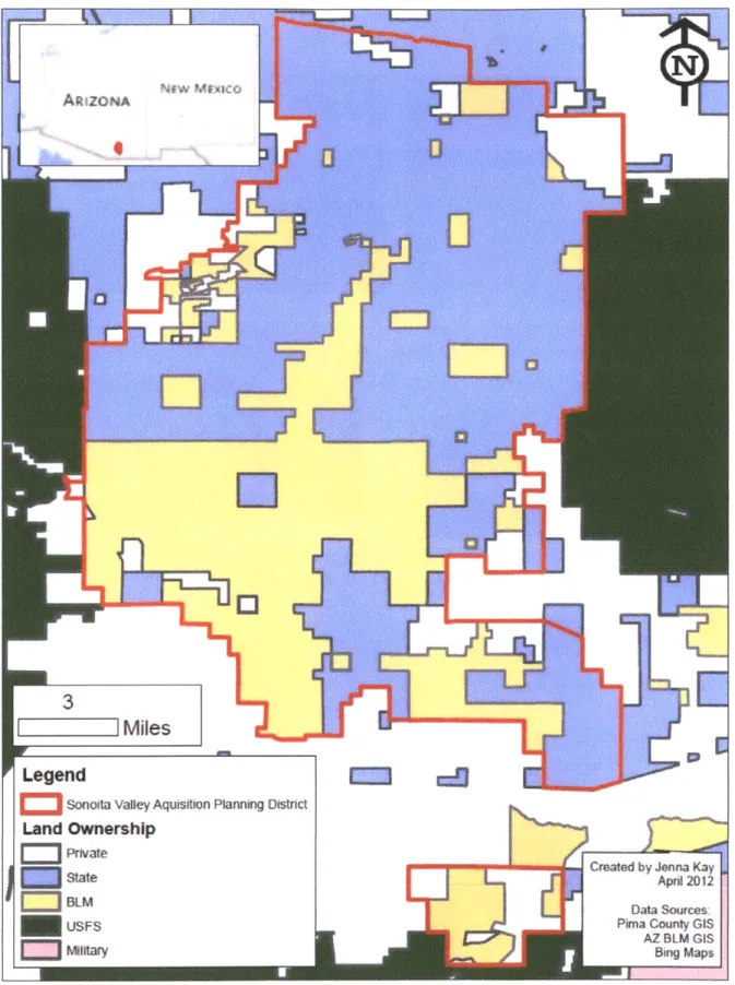
Figure 3: Map of the Las Cienegas NCA and SVAPD 22
Figure 4: Map of land ownership in the Sonoita Valley 23
Figure 5: Images of the Sonoita Valley 24
Figure 6: Endangered species in the Sonoita Valley 24
Figure 7: A simple state-and-transition model 30
Figure 8: Map of land ownership in the Malpai Borderlands region 40
Figure 9: Images of the Malpai Borderlands 41
Figure 10: Images of four endangered Borderlands species 41 Figure 11: Brown and Curtin's framework of driving variables in the Borderlands 46 Figure 12: Model of the Borderlands ecosystem and monitoring plot locations 47
Figure 13: Map of fires in the Malpai Borderlands 48
Figure 14: Images of McKinney Flats 56
Figure 15: Experimental design for the McKinney Flats Project 57
Figure 16: Relief map of the Madrean Sky Islands 86
Figure 17: Water cycle in a semi-arid region 91
Figure 18: Diagram of the Las Cienegas Adaptive Management Framework 96 Figure 19: Diagram of the Las Cienegas Biological Planning Process 97
LIST OF TABLES AND APPENDICES
Table 1: Key elements of CAM, blank 19
Table 2: BLM Las Cienegas Resource Management Plan goals 26 Table 3: Key elements of CAM, Las Cienegas Adaptive Management Program 37 Table 4: Key elements of CAM, Prescribed Fires in the Peloncillo Mountains 55
Table 5: Key elements of CAM, McKinney Flats Project 62
Table 6: Cases considered for this project 83
Table 7: More possible CAM efforts 83
Appendix A: Cases considered for this project 83
Appendix B: Interview questions 84
Appendix C: Resource management in the Sky Island region 86 Appendix D: Parties involved in Las Cienegas Adaptive Management 95 Appendix E: Las Cienegas Adaptive Management Framework and Biological Planning
Process Diagrams 96
Appendix F: Federal and state agency attitudes about the Las Cienegas Adaptive
Management Program 98
CHAPTER 1: INTRODUCTION A hypothetical story
Imagine a group of ranchers, environmentalists, recreation enthusiasts, public agency scientists and land managers working together to manage a semiarid grassland ecosystem in southern Arizona. This group of people with multiple interests and perspectives negotiate with each other and build consensus regarding grassland management decisions. They may
collectively decide, for instance, if, when and where to implement a prescribed fire. When the group feels like it needs more information, like the impact a fire will have on a specific plant species, they seek to find answers to their questions by integrating management decisions with science experiments. They might, for example, implement a few prescribed burns in a controlled and replicated fashion and collect data over the course of a decade on the impact the fires have on the species of interest. The group then incorporates this information into subsequent fire management plans and experiments.
The stories I am going to describe in this thesis are not very different from this
hypothetical account. Groups of people with a broad range of interests have collaboratively tried to address natural resource management issues when it has been unclear about how to proceed, and they have made an effort to link scientifically-based hypothesis-testing with actual
ecosystem management decisions. Natural resource managers and academics call the
combination of such collective and experimental management processes collaborative adaptive management, or CAM.
how and why collaborative decision-making became connected to this resource management approach, 3) my case-selection process, research questions and methodology, and 4) a road map of what you can expect in the rest of this document.
What is adaptive management?
For most of the 2 0th century, environmental management policies established a fixed set
of actions designed for stable economic and environmental conditions (Holling 1978).
Environmental assessments assumed descriptive "state of the system" surveys were a good way to evaluate environmental conditions that and that separately describing each part of an
ecosystem could lead to understanding the system as a whole (Holling 1978). These approaches, however, led to inflexible, unfocused and arbitrary environmental management and assessment
strategies (Holling 1978).
Adaptive management is a resource management approach that aims to address these chronic environmental management and assessment problems. In 1978, ecologist C.S. Holling and colleagues at the University of British Columbia formally introduced the term "adaptive management" as an alternative to conventional natural resource management and science. Holling drew on ideas in systems theory and argued that ecosystems are dynamic and complex,
humans do not fully understand how natural systems work, how human behaviors affect natural systems, and much of what we know is wrong. Despite these uncertainties, management and policy decisions need to be made. Holling proposed bringing scientists, agency managers and policy makers together in a series of workshops to develop models of how they currently think the system of interest works. The group would then conduct experiments - some long-term and
some integrated into actual management activities -to learn and adjust their models as understanding improved. By testing hypotheses about the impact of human interventions on
complex natural systems, place-based research conducted in conjunction with management actions could produce relevant information that could then be applied to improve future
management decisions. This approach would permit a way to "learn by doing," allow for large-scale experimentation as opposed to small-plot experiments, and had the potential to improve communication between decision makers and scientists. (Holling 1978)
In theory, by using an iterative approach of planning, implementing, monitoring, evaluating and adjusting management actions, we can learn about natural systems, gradually reduce uncertainty, and improve management decisions and policies over time (Figure 1)
(Holling 1978, Walters 1986, Lee 1993).
Figure 1: A simple diagram of adaptive management (from DOI 2010).
(active adaptive management) instead of just monitoring whatever happens to be going on in the area of interest (passive adaptive management). Repeated hypothesis-tests would provide a deliberate way to increase knowledge and decrease uncertainty through management
interventions. Walters also emphasized that long-term monitoring would be needed if policies were to be designed in a way that incorporated ecological feedback. More recently, Allen and Gunderson (2011) emphasized the need to test competing hypotheses about management strategies in order to compare results and determine the best way to proceed.
What is collaborative adaptive management?
CAM theory proposes 1) that treating management interventions as experiments will help people improve their understanding of ecosystem functions and their impact on them, 2) by adjusting decisions based on what is learned, policies can change and improve in response to new information, and 3) by involving a broad range of people in an AM process, trust will improve between the various parties and the group will find a way to agree on how to proceed, despite their contending interests.
The "collaborative" in collaborative adaptive management stems from Kai Lee's (1993) work and refers to collaboration in the sense that all stakeholders affected by a natural resource management decision should be at the planning table and involved in implementation. Lee added "social learning" to the discourse of AM. He defined social learning as a combination of adaptive management and political change and viewed multi-party negotiations and guided conflict
resolution as an integral way of making social learning happen. Lee argued that social learning would develop from the knowledge within a network of organizations, conflict between
large ecosystems where complex systems (multiple jurisdictions, multiple uses, interdependence of people, uses and ecosystem services), contentious interests, and many people were affected.
Lee also advocated that the public should be involved in designing experimental protocol and in data collection so that 1) the community could foster and sustain learning over time, 2) experimental policies would be viewed as legitimate in the eyes of the public, and 3) the political costs of being wrong would be less than if the public were not included. A broad range of
stakeholders representing the full range of interests affected by the management decisions under discussion would need to be integrated into an AM process. It would not, however, be enough for a diverse group of stakeholders to just be present at meetings; to be meaningfully involved in a public decision-making process, stakeholders would need to actively engage in seeking
consensus with the other parties at the negotiation table (Lee 1993, Brandenburg 2005). By having key interests represented and engaged in collaborative problem-solving, the resulting decisions would likely be more fair (in the eyes of those affected), efficient (in terms of creating solutions with more value), stable (over time), and wise (according to the information available at the time), than would otherwise result from a less inclusive or engaging process (Susskind and Cruikshank 1987).
CAM not only requires the meaningful involvement of a diverse range of stakeholders, the collaboration also needs to withstand the length of time it takes to complete a CAM process, which can last several years or decades. Ongoing collaborative efforts typically take the form of informal or formal networks of public, private and not-for-profit organizations and/or
individuals, that develop and implement management plans (Sabatier et al. 2005, Mandell 1999). To be successful, a long-term collaborative requires roles and responsibilities that are different
1999, Sabatier et al. 2005). Ongoing leadership, staffing, and data collection need to be coupled with the ongoing commitment of stakeholders and their organizations (Margerum 2011). To accomplish this feat, there need to be incentives in place that encourage participants to maintain their involvement over time (Margerum 2011).
In order to assess whether CAM is taking place or not, it needs to be explicitly defined. I describe 14 key aspects of a CAM process that have emerged out of more than 30 years of theory building and attempts at implementing AM and CAM. This list has been modified from Levine (2004) and integrates ideas found in Allen and Gunderson (2011), Doremus et al. (2011), Susskind (2011) and Margerum (2011).
1. Convene a working group that includes representatives of all key interests: Anyone can initiate a CAM process. The working group, however, should include representatives of all key interests such that no one has been identified as missing from the group, there have been no complaints of exclusion, and anyone who could potentially block or stall implementation of agreements has been invited to join. Public agencies necessary for political action should be involved.
2. Define problem(s): The working group identifies specific problem(s) about what is not working. needs to change, or is unknown about the system of interest. Divergent perspectives on issues are fine (and expected).
3. Decide if CAM is an appropriate tool: The working group needs to decide if CAM is an appropriate approach for addressing the problem(s) of concern. CAM is appropriate if
management interventions are controllable and the outcome of possible actions are unknown. If outcomes are well known, there is no need to invest in CAM; best management practices can be implemented instead. If management interventions cannot affect the main problem, such as climate change, then tools such as scenario planning may be more appropriate than CAM. CAM is also not appropriate if the proposed management strategies can cause irreparable harm, such as killing several species, or if the ecosystem function(s) of interest cannot be measured.
4. Develop a process agreement: If the working group decides CAM is an appropriate choice, the group needs to collectively create an agreement on how the process will work. Roles and responsibilities should be clearly defined including who is managing the process and how decisions will be made. Specific tools that will help create organizational structure need to be identified; this may include regular stakeholder meetings and a system for clear and
consistent communication in between meetings (such as creating a website and email list to circulate agendas, meeting notes and other relevant information). A neutral facilitator is
another possible tool that may be used to help foster public participation, collaborative problem solving, and mediation of conflicts.
5. Create ecologically based goals and objectives: The working group develops unanimously supported goals and objectives that are specific enough to determine whether they have been accomplished or not. Objectives should be designed in a way to measure progress towards the identified goals and should be time-bound.
6. Specify a conceptual model: The working group designs a model or uses a pre-existing one that conveys the collective understanding of how the system in question functions, identifies key uncertainties regarding the system, and addresses influential variables that are outside of the system. Since the group develops the model, it should be credible in the eyes of everyone involved in the process.
7. Develop hypotheses: The working group develops hypotheses about the impact that possible management actions will have on the system of interest. Multiple hypotheses can be tested and not everyone will necessarily agree with each hypothesis, however, there is group agreement about what will be tested.
8. Design management experiments/interventions to test hypotheses: The working group develops an experimental design that includes controls of variables of interest and replication of hypothesis tests. Hypothesis tests and management activities are integrated. Unanimous agreement is sought in the experimental design.
9. Design a monitoring plan: The working group develops and agrees on monitoring protocol designed to detect the ecological changes of interest and measure the impact(s) of the management interventions.
10. Implement management interventions: The working group, a subset of the working group, or an agreed upon additional party implements management interventions according to plan. Minor hiccups can be expected, but intentional disregard or obstruction of plan
implementation is unacceptable.
11. Implement monitoring plan: The working group, a subset of the working group, or an agreed upon additional party implements monitoring protocol according to plan. Minor hiccups can be expected, but intentional disregard or obstruction of plan implementation is unacceptable.
12. Evaluate results of experiment: The working group deliberates over the interpretation of the data that has been collected and its implications on management goals and objectives. Significant findings and surprising information are not ignored. Not everyone will agree on the meaning of the data or what should happen in response to it.
is sought in making these decisions.
14. Cycle is continuously repeated: The working group continues using this process until the problem has been solved or uncertainties are no longer a concern. Stakeholder group representatives consistently attend meetings over time. Funding is sufficient over time to implement the desired experiments, data analysis, and group meetings. If an individual leaves the working group, another representative of the same stakeholder group replaces him or her. If additional people or interest groups are identified as missing or would like to join the working group, they are invited to do so.
Finding cases: CAM in practice
Before embarking on this project, I was having a hard time grasping what CAM might look like in practice. How would a group of people work together over the course of several decades to do AM? Could this kind of an approach ever be implemented well'? When I raised the idea of doing a project about CAM to my advisor, he essentially said, "that's an interesting idea, good luck finding cases to study." At the time I did not quite realize how difficult it would be to find existing CAM projects that have been going on long enough that I could research what they have done. It was also unclear what exactly should be considered CAM since few projects are explicitly labeled as such. And yet, groups of people have been resolving science intensive disputes and collaboratively managing natural resources for decades (Innes and Booher 2010, Wondolleck and Yaffee 2000, Susskind et al. 2011, Margerum 2011). There just had to be
groups of people effectively collaborating with each other and integrating experimentation and monitoring into ecosystem management decisions. They may not be calling it CAM, but there
were probably groups of people somewhere doing something like it.
To select the three cases used in this study, I conducted informational interviews with several academics, consultants and practitioners who study or use CAM and I asked them for examples of natural resource management efforts in which they thought a diverse range of
stakeholders were genuinely collaborating with each other and in which active scientific
experimentation and/or monitoring was used to inform management decisions. After compiling a list of possible cases (see Appendix A), I looked for programs in which implementation of CAM
had been ongoing for at least ten years and at least two iterations of experimentation had been completed. As I conducted cursory research into each of the cases, I found myself eliminating programs as candidates for this project either because they were obviously missing key elements of CAM, or because they were not far enough underway to study. For instance, the Platte River Recovery Implementation Program has a promising collaborative organizational structure and clear plan to implement AM, but experiments have not yet begun. The Glen Canyon Dam Adaptive Management Program has a collaborative working group and more than 15 years of data collected through water flow experiments, but, despite the data indicating that dam
management should change to improve Colorado River riparian ecosystems, no adjustments to management decisions have been made and AM is not happening (Susskind et al. 2011).
My case selection process was by no means a comprehensive endeavor, but it certainly indicates the challenge of finding examples of CAM in practice. I ended up choosing two programs (and 3 specific cases within these programs) that represent different organizational structures, and, for logistical ease, are located within the same geographic region in the United States. This study examines: the Las Cienegas Adaptive Management Program, and two projects affiliated with the Malpai Borderlands Group -- Prescribed fire planning in the Peloncillo
Mountains and the McKinney Flats Project (Figure 2). All three cases are located within the Sky Island region of the southwestern U.S. in which a complex of short mountain range "islands" of cooler and wetter ecosystems rise above a "sea" of grasslands and desert (read more about the
Figure 2: Location of case study areas: 1) Las Cienegas National Conservation Area (photo credit: Jenna Kay), 2) Prescribed fires in the Malpai Borderlands (photo from Malpai
Borderlands Group 2012), 3) McKinney Flats Project in the Malpai Borderlands (photo from Curtin 2005).
Research questions and methodology
This study aims to answer three questions: (1) What does CAM look like in practice'? (2) Are my cases actually examples of CAM? Why or why not? (3) If so, what is promoting or
enabling CAM to happen in these efforts?
I used semi-structured interviews with individuals involved in the implementation of the three projects. The interviews were intended to gather information about program structure, design and activities, and the opinions of participants and observers involved or affected by each natural resource management effort (see Appendix B for a copy of interview questions).
I interviewed 21 natural resource managers and scientists, public agency representatives, community members, environmental advocates and academics (see Appendices D and G). 7-14
people were interviewed about each site area. A snowball sampling technique was used to select interviewees, asking each person that I contacted for recommendations of other people with whom I should speak.
I assume that CAM has happened if all the key elements of CAM outlined earlier in this chapter have taken place (Table 1). 1 will fill in this grid as I discuss each case.
Table 1: Key elements of CAM. I will fill in this table as I discuss each case using the following key: = element is consistently present, C = element is sometimes present,
O=element
is absent.Convene a working group that includes representatives of all key
mnterests
Define problem(s)
Decide if CAM is an appropriate tool
Develop a process agreement Create ecologically based goals and objectives
Specify a conceptual model Develop hypotheses
Design management
experiments/interventions to test hypotheses
Design a monitoring plan Implement management interventions
Implement monitoring plan Evaluate results of experiments Reassess and adjust the problem
statement, goals/objectives, process, conceptual model, interventions, and monitoring plan
Road map
In chapters 2 and 3, 1 present my two cases. Chapter 4 analyzes my findings across all three cases and Chapter 5 discusses the implications of my findings for current and future CAM practitioners.
CHAPTER 2: COLLABORATIVE RESOURCE MANAGEMENT IN THE SONOITA VALLEY
What are the Las Cienegas National Conservation Area and the Sonoita Valley Acquisition Planning District?
The Las Cienegas National Conservation Area (NCA) is 47,279 acres of Bureau of Land Management (BLM) land in southeastern Arizona, on the outskirts of the Tucson metropolitan area (Figure 3). The Sonoita Valley Acquisition Planning District (SVAPD) is an additional 95,609 acres of state, private and BLM lands adjacent to the NCA (Figures 3 and 4). Together they make up 142,888 acres of planning area in the Sonoita Valley. The NCA and SVAPD support five of the rarest ecosystems in the American Southwest: cottonwood-willow riparian forest, cienega marshland, sacaton grass floodplain, mesquite bosque, and semi-desert grassland; are home to hundreds of species of birds, mammals, amphibians, reptiles and fish; house seven endangered species including the Gila topminnow, Mexican garter snake, and Western yellow-billed cuckoo; and have two eligible wild and scenic river segments (Figures 5 and 6). The Las Cienegas Adaptive Management Program aims to improve the ecological health of the planning area while managing it for multiple uses including livestock grazing, recreation, and cultural heritage.
Figure 3: Map of the Las Cienegas NCA and SVAPD.
Oro
Valley
u e 77TuTson
X e a ,i n .3,Green
Valley
&rt 83 Maurit Huachuc CtSierra Vista
p
Movnt~4~ LegendSonoita Valley Aquisition Planning Distnct
] Miles Las Cienegas National Conservation Area
Crested by Jenna Kay Apr 2012
Data sources: Pima County GIS
AZ BLM GIS Bng Maps rrita~ 85 Rio Rico 9,3
Nogaies
20 7a r Nat4 onFigure 5: Images of the Sonoita Valley (clockwise from top left): semi-desert grassland (photo credit: Jenna Kay); cattle grazing in the NCA (photo credit: Jenna Kay); riparian area along Cienega Creek with the endangered Gila topminnow in forefront (photo from Bodner et al.
2007); view across the upper Cienega Creek watershed (photo from Simms et al. 2006).
Figure 6: Endangered species of the Sonoita Valley (from Pima County, in Simms et al. 2010).
Iestern
flycatcher
Western yellow-billed cuckoo Gila topminnow
luachuca water umbel
Gila chub
-aWy -Ause of P-s C-Aej 3DCP
Development of a CAM approach
In 1988, the BLM acquired a piece of land on the outskirts of Tucson, AZ and embarked on a conventional planning process. As a result of unclear plans, lack of public participation, and exclusion of key stakeholders, the planning process reached an impasse. In response to the conflict, the BLM convened a group of stakeholders to develop an alternative plan. Karen Simms, an ecosystem planner for the BLM Tucson field office, served as the lead for "re-doing" the land management plan using a more collaborative approach this time.
Karen led an internal BLM team that managed and prepared official documentation for the plan and she convened a large stakeholder group, called the Sonoita Valley Planning Partnership (SVPP). The SVPP was a voluntary association of about 20 federal, state and local agencies, organizations and private citizens who worked together to develop solutions regarding public land in the Sonoita Valley/upper Cienega Creek watershed. Environmental, recreation, ranching, and small-scale mining interests were represented. Agency involvement included representatives from BLM, Coronado National Forest, Natural Resource Conservation Service (NRCS), U.S. Geological Survey (USGS), Arizona Game and Fish Department (AGFD), Arizona State Land Department (ASLD), Pima and Santa Cruz Counties. A neutral facilitator initially helped the group use a consensus-based process to make decisions. Karen Simms, however, ended up facilitating most of the negotiations. The discussions were open; anyone could join and anyone could leave at any time.
After six years of monthly meetings, the SVPP came to an agreement that was adopted by the BLM as a resource management plan (RMP) for the Las Cienegas NCA and SVAPD. The RMP outlines ten broad goals for the planning area (Table 2), ecologically based objectives for
achieving each goal, and specific management actions describing how to accomplish the objectives.
Table 2: List of the goals for the Sonoita Valley, developed by the Sonoita Valley Planning Partnership and adopted as the goals for the BLM Las Cienegas Resource Management Plan. This list does not include specifics details outlined under some of the goals (BLM 2003, 4-5)
1. Maintain and improve watershed health
2. Maintain and improve native wildlife habitats and populations 3. Maintain and restore native plant diversity and abundance 4. Protect water quality
5. Protect water quantity
6. Assure sustainability and a complementary relationship of mineral resources to the protection of water quality and quantity
7. Maintain the region's scenic beauty and open space
8. Sustain compatible traditional, current, and future use of land
9. Promote stewardship of the resources to accommodate current and future opportunities and demands
10. Manage the cultural resources in the planning area in a manner that provides for their preservation and protection and also avails selected properties for scientific, public, and sociocultural uses
While the SVPP stakeholders could agree on overarching goals and objectives, they could not agree on whether grazing was good or bad (more than 90% of the planning area is open to cattle grazing) and there was much discussion within the group about how to go about reaching the agreed-upon goals. Therefore, the SVPP decided to base future decisions on monitoring data rather than conflicting ideologies. The RMP states that SVPP collaboration will continue during plan implementation and that an AM approach will be used to adjust and improve management actions over time. The group also successfully petitioned Congress to designate the piece of BLM land as a National Conservation Area.
The Las Cienegas Adaptive Management Program and collaborative implementation process officially began with the approval of the RMP in 2003, and, according to Lynn Scarlett (2011), "The Las Cienegas NCA is the first major BLM-administered land area to
simultaneously engage community-based planning and community-based implementation of the adopted plan through adaptive and outcome-based practices" (8).
The Las Cienegas Adaptive Management Program
Program structure
The BLM leads the collaborative and adaptive management process associated with RMP implementation and hosts two meetings each year, called biological planning meetings. These events are open to anyone who would like to participate and are largely made up of
representatives of the same organizations involved in the initial planning process. Approximately 30 people typically attend. The meetings tend to have an interactive agenda in which monitoring data is shared. field trips are taken to see different parts of the planning area so everyone can
"see" what the data looks like, and facilitators lead discussions on the implications of the data and how it can inform future management decisions.
Stakeholders attending biological planning meetings are not a formal federal advisory committee or legislatively enacted body. Therefore, the group has the flexibility to structure its decision-making process to meet its needs. The group's informal status also means it cannot officially make recommendations to the BLM and the BLM is not obligated to use outcomes resulting from group meetings. Instead, the stakeholders give feedback to the BLM who then strongly considers the group's suggestions in its official decisions.
In addition to the biannual biological planning meetings, there are four technical teams, or sub groups, within the biological planning process: the uplands team focuses on grasslands, the riparian-aquatic group focuses on those areas, the landscape team connects Sonoita Valley planning efforts to regional concerns and impacts, and the heritage team focuses on cultural and recreation resources. The four subgroups meet several times throughout the year to analyze monitoring data in more detail than is done at the larger biological planning meetings. There is also a fifth group, the coordinating team, made up of the conveners of the four working groups. The coordinating team meets periodically throughout the year and serves as a way to improve communication and coordination between the technical teams (Robertson 2012). For a diagram of the Las Cienegas Adaptive Management Framework and Biological Planning Process, see Appendix E.
Both the program structure and culture of meetings has shifted over time. A few years into plan implementation, for instance, the stakeholder group was struggling to collaborate; tension was growing between participants and within the BLM (Simms 2012). (Read more about
this in Appendix F.) The group was also interested in broadening the scope of how they were using adaptive management (Simms 2012). Karen was familiar with the U.S. Institute for
Environmental Conflict Resolution (USIECR) and asked the Institute for help improving collaboration within the biological planning/adaptive management process. The BLM entered into an inter-agency agreement with the USIECR, developed a scope of work, and used a
competitive application process to select a mediator. Tahnee Robertson was hired by USIECR in 2009 and has been supporting the adaptive management program since then.
Tahnee was originally hired to determine potential improvements for the biological planning process, such as suggesting an appropriate framework and sideboards, clarifying the
role of stakeholders and BLM staff, and facilitating meetings. She also created and manages the group website and is in the process of conducting a stakeholder analysis. At this point, several members of the group find it hard to imagine what it would be like working without a mediator. Overall direction of the group, meeting management, tone and comfort of participants, ability to address fairly sensitive issues, and documentation of meetings has improved as a result of Tahnee's involvement in the biological planning process (Kay 2012).
Design of management interventions and monitoring protocol
The RMP outlines goals, objectives, management actions and monitoring strategies. The SVPP based objectives on a land health standard defined for each habitat-type (based on NRCS Ecological Site Descriptions and Arizona Standards for Rangeland Health). Objectives are time-bound and specify what is trying to be accomplished. For example, one objective is to maintain or achieve <30% exposed soil surface (bare ground) in 80% or more of grassland ecological sites in the planning area by 2015 (BLM 2003). Another objective is to maintain or achieve a high similarity index (>50%, by weight) to historic climax plant communities in 80% or more of the ecological sites in the planning area by 2015 (BLM 2003).
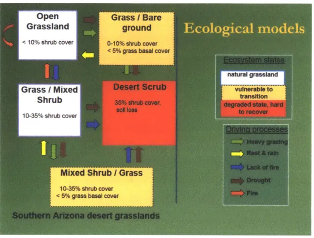
Once the group identified the desired conditions for each habitat-type, they used state-and-transition models to highlight the major driving forces of change that impact the conditions of an ecological site (Figure 7). They also used the models to identify appropriate management strategies for moving a site with undesired conditions towards a more desired state and
Figure 7: A simple state-and-transition model of desert grasslands in Southern Arizona (from Simms et al. 2010).
No hypothesis-testing experiments with controls and replications were written into the RMP. Instead, CAM at Las Cienegas was based on a passive adaptive management design (Walters 1986) to test management hypotheses using descriptive monitoring techniques. A few University of Arizona researchers have designed experimental projects in the planning area. One research project tested the effects of grassland restoration efforts on birds in the NCA and another project involved examining various vegetative treatments, such as prescribed fire and manual mesquite removal, to better explain what was happening in response to certain invasive species management decisions. It seems like the Las Cienegas Adaptive Management Program could benefit from more of these types of scientific experiments, to learn about the impact of
management strategies faster than they may otherwise be able to accomplish just through monitoring. (The Audubon Society's Appleton-Whittell Research Ranch Sanctuary, located within the planning area, has been cattle free since 1968 and is used as a comparative reference site to other parts of the planning area. More recently, several cattle exclosures have been added throughout the NCA. While these comparative sites may help distinguish between the impacts of cattle grazing and other factors such as climate, the sites have not been set up as a rigorous place-based experiment.)
Implementation of management interventions and monitoring protocol
BLM staff, grazing allotment lessees, volunteers, and additional partners implement the RMP management actions. A few hundred thousand dollars are spent each year on management interventions and this number varies depending on grants and other available funding sources.
Projects completed so far include managing livestock flexibly (which is an ongoing effort); Ian Tomlinson, owner of the Vera Earl Ranch. manages approximately 1000 head of cattle on BLM
land and presents and discusses his grazing plans during biological planning meetings. Several fences have been built to keep cattle out of riparian and other sensitive areas. More than 12,000 acres of vegetation have been treated to control invasive plants using chemical and mechanical brush removal techniques and prescribed fires. Black-tailed prairie dogs have been reintroduced to the planning area. Several erosion control structures have been built.
While most management interventions have been implemented according to plan, the University of Arizona invasive species experiment ran into problems during implementation when a BLM fire manager did not alter the prescribed burn plan for the year to accommodate the
More than 40 grassland-monitoring plots are located in the planning area. There are also several fish sampling locations, riparian vegetation and channel morphology measurement locations, and fire effects monitoring locations. Data collection takes place two times per year and is conducted by a few biologists, range experts and a handful of volunteers. It takes approximately 10-days of fieldwork to collect all of the desired measurements. Additional monitoring plots are set up to measure the before and after effects of specific management actions, to assess whether a vegetation treatment, for example, is actually getting the group closer towards achieving its objectives. When prescribed fires, manual brush removal, or
chemical applications are used to remove invasive species, data is collected to measure how fast the undesired species returns to the area after its removal.
In 2004, the BLM signed a cost-share agreement with The Nature Conservancy (TNC) to help improve the monitoring program for Las Cienegas. The goal of this effort was to ensure that
1) the data being collected was measuring the ecologically based objectives in the RMP, 2) the sampling and measurement techniques would detect ecosystem changes resulting from
management actions, and 3) a solid foundation of information was being provided to BLM managers and the stakeholder group that was useful for informing future decisions. Several changes were made as a result of TNC involvement. For instance, the RMP recognizes that shrub encroachment is a problem for grasslands habitat, but it was not being monitored. Thus, shrub coverage is now monitored in all grassland areas. TNC also recommended to increase the sampling intensity for certain measurements to better detect change (instead of collecting a few hundred data points in a sampling plot approximately 1000 measurements are now collected). The more refined data collection methods have shown changes that would not have been detected with the old system. (Bodner 2012, Simms 2012)
Evaluation offindings
When a stakeholder shows up to a biological planning meeting, s/he can expect to engage in discussion about the information being presented to the group. This culture of discussion, however, has not always been present. For the first few years of biological planning meetings,
the group struggled to really use the gatherings as a place to deliberate over the interpretation of monitoring data and its application to management decisions. Gita Bodner of T NC explains: "stakeholders and staff would look at [the synthesized data produced by the TNC]... and say, 'okay, thank you"' (Bodner 2012). There was little to no discussion of it. Gita continues: "And then the grazing permittee would describe his proposed grazing rotations and number of cattle for the year and everybody would say 'yes."' (Bodner 2012). So, there was a mechanism for looping new information into decision-making, but it was not entirely effective (Bodner 2012). Karen, Gita and a few others worked to shift the expectations of the group to be more actively involved in data interpretation and decision-making.
The Las Cienegas monitoring program is designed to measure whether conditions in the Sonoita Valley are progressing towards the management objectives or not. Data shows that some management strategies have been particularly effective at achieving RMP objectives, some strategies have not, and, some data is just hard to decipher. In 2011, the desired ground cover objectives had been met (more than 80% of sites designated as grassland communities had less than 30% of exposed soil surface). This was not a linear trajectory, however, and between 2004 and 2011, the percent of monitoring sites meeting this objective varied between 100% and 24%. During years with less rain, fewer monitoring areas met this objective, indicating that
assessing ecological progress. Another objective in the RMP is to have perennial grass basal cover in more than 10% of all grassland areas. In 2004, 54% of sites monitored met this objective; in 2011, 34% met the criteria. This negative trend suggests that either management activities have not led to desired ecological outcomes, or that other factors besides management activities are determining the changes in ecological conditions.
Adjustments
A handful of management interventions have been adjusted incrementally as a result of the stakeholder group reviewing and discussing data together. One example took place when the ranching lessee was surprised to find out that what he thought looked like good fodder for his cattle was not. Monitoring data showed that the perennial grasses that died over the winter were overgrown by annual plants during the summer. There was concern by a few range scientist experts that if the permittee carried out his original grazing plan, it would damage the land and his bottom line because there would not be enough food for the cows, since annual grasses would not last as long as perennial grasses. The group agreed that the permittee should not graze as many cattle on that particular allotment as he had proposed. (Kay 2012)
Another specific management change that may result from data analysis and discussion has to do with restoration of the Cienega Creek riparian area. Livestock were fenced out of a riparian area with the hopes that it would help the ecosystem regain some of its natural functions. The vegetation grew back much faster than anticipated and the population of the endangered Gila topminnow living in the stream rapidly declined in response to the increase in shade. Karen Simms reflected, "we probably would have implemented taking the cattle off in more of a
staggered way so that we had more diversity of habitats." The RMP outlines the possibility of reintroducing beaver to riparian areas in Las Cienegas and Karen explains:
Now we're saying maybe now's a good time to talk about putting the beaver out there because they would help reduce some of that tree cover, open systems up and might benefit the native fish. On the other hand, there are people that don't agree with that because they are concerned about the beavers creating big pools that would attract bullfrogs, which is an exotic species for us and would be detrimental. If we do put the beaver out there, we will set it up with monitoring. If we see that it's causing more of a problem than a benefit, well, then we can make the decision to take the beaver back out if we want to.
By building possible options into the RMP, the group has promoted opportunities for flexible management.
While there are several instances of small management changes resulting from data collection, analysis, and group discussion, few dramatic changes have resulted from biological planning meetings (Kay 2012). One interviewee explained that it is not always clear what to do in response to the data. This raises the question: if the group is open to change but does not make adjustments, is AM happening? (Read about federal and state agency responses to this question in Appendix F).
Continuation of the CAM cycle and concerns about future implementation
The Las Cienegas Adaptive Management Program has been ongoing for nearly ten years and has greatly benefited from having an enthusiastic stakeholder group involved at meetings at least two times per year, the continuous leadership of Karen Simms, and the assistance of a neutral facilitator.
be addressed with AM. Several people interviewed mentioned that the BLM is not well set up with a succession plan for Karen Simms. Interviewees also expressed their concern about some stakeholders no longer attending meetings. Others were concerned that there is currently a missing stakeholder, the Arizona State Land Department, the largest landowner in the planning area. Figuring out how to keep people coming back will be key to sustaining a long-term collaborative effort in the Sonoita Valley. Issues such as climate change, Tucson's groundwater
depletion, and water contamination from nearby mining operations are largely beyond the control of activities at Las Cienegas, but will/do severely impact ecosystem health there. The stakeholder group has decided to add a new tool into their management strategy and will use scenario planning to address climate change concerns.
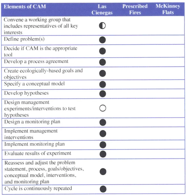
Summary of Case 1
Las Cienegas has benefitted from a group of diverse stakeholders who have become committed to a long term resource management project and are open to implementing a flexible resource management plan, learning, and adjusting their management decisions over time. While the group working at Las Cienegas feel like they have muddled their way along, figuring out how to do CAM as they go, they are continuously collaborating and are open to adjusting their management strategies. Nearly all of the key elements of CAM are present in the Las Cienegas Adaptive Management Program, and yet, the three weakest aspects of Las Cienegas CAM are 1) the absence of a key stakeholder and 2) designing experiments to test specific hypotheses (Table 3).
00
Table 3: Key elements of CAM. 0= element is consistently present, = element is sometimes present, = element is absent.
Convene a working group that includes representatives of all key interests
Define problem(s)
Decide if CAM is the appropriate tool
Develop a process agreement Create ecologically-based goals and objectives
Specify a conceptual model Develop hypotheses
Design management
experiments/interventions to test
O
hypothesesDesign a monitoring plan Implement management interventions
Implement monitoring plan Evaluate results of experiment Reassess and adjust the problem statement, process, goals/objectives, conceptual model, interventions, and monitoring plan
Cycle is continuously repeated
The currently missing representative from the Arizona State Land Department has not yet caused a problem for the stakeholder group, but as the largest land owner in the planning area, with a state mandated mission to sell land for money, this missing participant could be
in their data. First, socio-ecological dynamics in Las Cienegas are complex and take several years of data collection to identify statistically significant trends. Second, since monitoring does not provide controls for certain variables such as climate, it is difficult to know why perennial
grasses are not growing in a certain area - it could be a result of livestock grazing, climate, or something else. This lack of clarity makes it challenging for the group to know what to do with their data or make significant adjustments to management activities.
CHAPTER 3: COMMUNITY-BASED CONSERVATION IN THE MALPAI BORDERLANDS
What are the Malpai Borderlands?
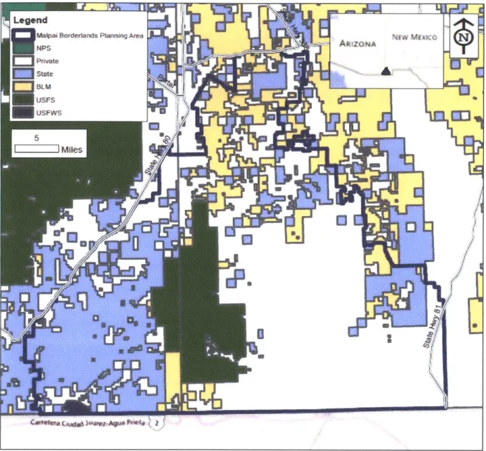
On the border of southern Arizona and New Mexico, there are approximately 800,000 acres (1,250 square miles) of continuous open space known as the Malpai Borderlands (Figure 8). The roughly triangular area is delineated by two highways and the U.S.-Mexico border and spans the Animas Mountains along the continental divide. The area also encompasses the Peloncillo Mountains and parts of the San Bernardino, Upper San Simon and Animas valleys. Watersheds flow north into the San Simon Valley and eventually into the Gila River or south into the Rio Yaqui system. Elevations range from approximately 3,800 to 8,500 feet.
Seven ecosystems converge in the Borderlands, making the area incredibly rich in biodiversity. The Sonoran and Chihuahuan Deserts, Desert Grasslands, Plains Grassland,
Interior Chaparral, Madrean Evergreen Woodland, and Montane Coniferous Forest provide home to many species of reptiles, amphibians, rodents and birds (Figure 9). At least 15 threatened and six endangered species live here including the jaguar (Panthera onca), chiricahua leopard frog
(Rana chiricahuensis), lesser long-nosed bat (Leptonycteris yerbabuenae) and New Mexico
Ridge-nose rattlesnake (Crotalus willardi obscurus) (Figure 10).
Land ownership forms an intricate mosaic made up of 53% private land, 23% Arizona or New Mexico state land, and 17% federal land (Figure 8). Fewer than 100 human families live in the area and most privately owned lands are working ranches.
Figure 8: Map of land ownership in the Malpai Borderlands region.
Created by Jenna Kay
ApA 2012
Data Sources: AZ BLM Spatial Data NM BLM Spatial Data Jornada Arid Land Research Programs, Malpai Borderlands Portal Bing Maps
Figure 9: Images of the Malpai Borderlands (clockwise from top-left): Baker 2 burn (photo from Malpai Borderlands Group 2012), grassland (photo from Malpai Borderlands Group 2012), mesquite tree (photo credit: Jenna Kay), and rancher with cattle (photo from Malpai Borderlands Group 2012).
Figure 10: Images of four endangered borderlands species (left to right): Jaguar (photo credit: Arizona Game and Fish Department), Lesser Long-nosed Bat (photo credit: T. Beth Kinsey), Chiricahua leopard frog (photo credit: Jeff Servos), and New Mexico Ridge-nosed rattlesnake (photo credit: Jim Rorabaugh, USFWS).
What is the Malpai Borderlands Group?
order to make a living. They were also frustrated with the Forest Service fire management strategy that seemed to embrace putting out wildfires as quickly as possible. Several of the ranchers thought occasional burning of the land was good for it and fire suppression might be the cause for trees and shrub encroachment into grassland areas. Also of concern was the increasing subdivision of ranchlands that meant less open range.
After several meetings with their ranching neighbors, federal and state agency
representatives, environmentalists, and science experts, in 1994, the ranchers formalized into a not-for-profit organization called the Malpai Borderlands Group (also referred to as the Malpai or Group from now on). The Group's mission statement says:
Our goal is to restore and maintain the natural processes that create and protect a healthy, unfragmented landscape to support a diverse, flourishing community of human, plant and animal life in our Borderlands region. Together, we will accomplish this by working to encourage profitable ranching and other traditional livelihoods which will sustain the open space nature of our land for generations to come.
The Malpai's approach is: "the group would never do anything to its neighbors, only with them
at their request, and whatever actions the group did take would be driven by good science, contain a strong conservation ethic, be economically feasible, and be initiated and led by the private sector, with public agencies coming in as our partners rather than with us as their clients" (McDonald 1994 in Wolfe 2001, 11). Today there are approximately 30 ranching families involved in the Group.
By the mid-I 990s, more than ten state and federal government resource and land management agencies were cooperating with the Malpai on projects aiming to preserve open space, reintroduce natural processes such as fire into the landscape, and prove that the Malpai style of ranching did not harm the land. New and unprecedented positions were created in both
the local Natural Resource Conservation Service (NRCS) and Coronado National Forest field offices in which individual agency representatives were to coordinate projects with the Malpai. The Nature Conservancy (TNC) had also become integrally involved with the Group. Additional
partners included University of Arizona and New Mexico researchers.
Malpai projects cover a wide range, from funding scientific research to implementing erosion control projects, and developing fire plans with the Forest Service. The group has also developed an innovative grassbanking system, in which ranchers can use grass on someone else's land in exchange for conservation work on their own. 77,000 acres of private land in the Borderlands are under conservation easements held by the Malpai. The Group has also been active in networking and collaborating with other groups who share similar concerns and problems as them such as the Massai.
Five part-time staff members handle the Malpai's administrative work and serve as the Group's nucleus. The board is made up of 12 ranchers and two retired Forest Service scientists; they meet several times throughout the year. A Scientific Advisory Committee consisting of experts in a variety of science fields meets annually and is consulted on Malpai monitoring and research projects. Agency representatives working with the Malpai on their prqjects all meet together each year as well. The board creates annual work plans and projects are pursued on a funding-available basis. The not-for-profit's money largely comes from donations and grants. The organization operates out of its office at Wendy and Warner Glenn's ranch near Douglas, AZ.
Development of the Malpai Science Program
A 10-year grant
Early on, the Malpai decided that good science would be necessary for resolving several of the uncertainties about resource management issues in the Borderlands. The Group wanted to use rigorous science as the basis for its decisions. According to rancher and Malpai Borderlands Group Executive Director, Bill McDonald: "[We] wanted the best and most credible scientists in the U.S. working with us... If the information and research is honest and unbiased, we'll let the chips fall where they may" (from Cook 2001 in Wolf 2001).
Rather than seek out rangeland experts, the Group looked for scientists with no
connections to ranching. They also decided that experimental science should take priority over observational science and that experiments should take place at a large scale so that the results would be meaningful to management decisions.
In 1994, the Forest Service Rocky Mountain Research Station received a 4 million dollar National Ecosystem Management Grant for the Southwestern Borderlands Ecosystem
Management Research Project (SBEM) in which $400,000 would be annually available for ten years. Representatives from several agencies, university researchers, and the Malpai put the proposal together. SBEM's goal was to use science to inform the development and
implementation of a comprehensive ecosystem management plan for the Malpai Borderlands. The project had three objectives: 1) summarize and synthesize existing information, 2) develop a comprehensive landscape inventory and monitoring system to serve research and management needs, and 3) identify specific research studies to fill priority knowledge gaps.
Several research projects were central to filling knowledge gaps. I only examine a few of them': 1) Prescribed burns were conducted in the Peloncillo Mountains to examine the effects of fire on vegetation and wildlife species, hydrology and sedimentology, and, 2) The McKinney Flats Project attempted to understand the interactions between fire, cattle grazing, climate and wildlife.
A model on which to base experiments
The location and purpose of Malpai experiments and monitoring efforts are connected to conceptual ecological models of the Borderlands ecosystem. Dr. Jim Brown, an ecologist at the University of New Mexico and one of his former post-doctoral students, Dr. Charles Curtin, a zoologist working at the Santa Fe Institute at the time, developed a framework for thinking about the primary forces that shape existing ecosystems in the Borderlands (Figure 11). These forces, or driving variables, can be thought of as the primary drivers of change in Borderlands
ecosystems. People can manipulate two of the driving variables: fire and grazing. The Malpai ranchers had already identified these as two areas that they thought were important to monitor and research in further detail, but Brown and Curtin's analysis independently validated the rancher's observations. (Curtin 2005)
Figure 11: Brown and Curtin's framework of driving variables in the Borderlands (from Curtin 2005,240).
The framework was used to develop a model of the different Borderlands ecosystems (Figure 12, left). The model was used to identify the placement of monitoring sites within each ecosystem and along border areas between different ecosystem types. Approximately 250
monitoring sites have been set up throughout the Borderlands to track vegetation changes (Figure 12, right). These were intended to provide baseline information for ecological status and changes in the area. Professional scientists are hired to annually collect data from the monitoring sites. This has not happened in the past few years due to funding constraints. More intensive efforts would take place near ecosystem boundaries, where systems were more complex and the most responsive to change (Curtin 2005). The McKinney Hats project (discussed later in this chapter) was such an effort located on the border of grassland and shrubland systems.
Figure 12: (Left) Model of the Borderlands ecosystem. The green line indicates the hypothesized direction of savanna ecosystem change in response to high grazing intensity and fire suppression (from Curtin 2005, 246). (Right) Monitoring plot locations in the Borderlands (from Curtin 2005, 241).
natura procss tomaintining Grassland at.Tevso a oocetaeasre fbrsi
4,4'
Suof-.Xn Fc tr 3 yeMC M"O o~trgp'Prot
Prescribed Fires in the Peloncillo Mountains
The Malpai wanted to restore a more natural fire regime to the Borderlands. To do this, the Group wanted to conduct large prescribed fires to test their assumption that fire was a key natural process to maintaining grassland health. The vision was to orchestrate a series of burns in the Peloncillo Mountains with before and after vegetation monitoring to assess the impact of burning on grass and brush species, hydrology and sedimentology. In 1993, a Memorandum of Understanding was created among the Malpai and nine federal, state, and county agencies establishing new fire management policies that would allow prescribed natural fire or wildland fire use for resource benefit. Five large prescribed fires have taken place in the Borderlands since
Bum (2008) (Figure 13). The prescribed fires have provided information that has been used to inform the construction of fire management plans throughout the region.
The prescribed fires exemplify 1) how treating a specific management action as an experiment can provide learning opportunities and help inform future management plans, and 2) through the use of a collaborative planning process made up of private stakeholders and
government agencies, risky management actions were tested that would not otherwise have been possible without widespread support.