HAL Id: hal-00081251
https://hal.archives-ouvertes.fr/hal-00081251
Submitted on 22 Jun 2006HAL is a multi-disciplinary open access archive for the deposit and dissemination of sci-entific research documents, whether they are pub-lished or not. The documents may come from teaching and research institutions in France or abroad, or from public or private research centers.
L’archive ouverte pluridisciplinaire HAL, est destinée au dépôt et à la diffusion de documents scientifiques de niveau recherche, publiés ou non, émanant des établissements d’enseignement et de recherche français ou étrangers, des laboratoires publics ou privés.
Using Ground-Penetrating Radar in the Southwestern
Egyptian Desert: Implications for Mars Shallow
Sounding
Essam Heggy, Philippe Paillou
To cite this version:
Essam Heggy, Philippe Paillou. Probing Structural Elements of Small Buried Craters Using Ground-Penetrating Radar in the Southwestern Egyptian Desert: Implications for Mars Shallow Sounding. Geophysical Research Letters, American Geophysical Union, 2006, 33, pp.L05202. �hal-00081251�
Probing Structural Elements of Small Buried Craters Using Ground-Penetrating Radar
in the Southwestern Egyptian Desert: Implications for Mars Shallow Sounding
Essam Heggy
Lunar and Planetary Institute, Houston, TX, 77058-1113, USA
Philippe Paillou
Observatoire de Bordeaux, UMR 5804, Floirac, 33270, France
We report results from a field survey performed on a recently discovered impact field in the southwestern Egyptian desert, using a 270 MHz Ground-Penetrating Radar (GPR). This hyperarid region has significant similarities to the Martian heavily eroded mid-latitude cratered terrains in terms of crater density, size, and geomorphology. Profiles across small-buried craters revealed a coherent sequence of tilted layers constituting the cratonic infill resulting from aeolian deposits. In the intercrater areas the radargram revealed a poorly-defined subsurface stratigraphy and the presence of shallow structural elements associated with potential evidences of the consequences of the shock effects, i.e., faulting, fractures, and chaotic bedrock. The radar-penetration depth varied from 2 to 15 m, depending mainly on the amplitude of the volume and multiple scattering in the subsurface, caused by fractures and debris created by the impacts. We conclude that mid-frequency GPR onboard future Martian rovers can successfully perform similar structural mapping.
Index Terms: (0933) Remote sensing, (5420) Impact phenomena, (6022, 8136) Cratering,
(5494) Instruments and techniques
1. Introduction
Mars exhibits heavily cratered terrains in its southern hemisphere and potentially buried craters in its northern hemisphere [Buczkowski et al., 2005], Its shallow subsurface is therefore likely fractured and brecciated, and heterogeneities caused by the impacts are more probably still present. Such context is very challenging for both deep and shallow radar sounding as volume and multiple scattering could dominate the attenuation in the backscattered signal [Grimm et al., 2005]. While the resolution of Mars Orbital Camera (MOC) images and Mars Orbiter Laser Altimeter (MOLA) data permits the identification of larger craters and hence estimation of the potential radar clutter [Orosei et al., 2003], a significant number of smaller craters, likely to be covered by the Martian superficial dust layer, may remain below the detection capability of the ongoing missions. Furthermore, high densities of small kilometer-sized craters are likely to cover a large portion of the Martian surface [Plaut, 2000]. Such crater population may be associated with consistent heterogeneities and fractures to a depth and horizontal extent on the order of the craters diameters, producing a layer of fractured and chaotic materials that may dominate the Martian shallow subsurface in the first tens of meters, even in areas originally assumed to be crater-free and favorable for shallow probing.
We hypothesize that such layers may significantly impact the ability of subsurface geophysical methods as GPR to penetrate the subsurface and distinguish the potential presence of deeper stratigraphy. On the other hand, based on the recent observations at the Schiaparelli
basin, it seems possible that cratonic infill could be evenly layered and amenable to geophysical profiling. Our objective therefore was to obtain profiles of analog areas on Earth to evaluate if such layering exists, and whether it can be probed using GPR. Our purpose is to explore the potential use of GPR on Mars as a method to probe the structural element of those small impact craters and reveal information on their filling; such an approach could provide a tool to assess some of the environmental history in Mars cratered terrain.
Ground-penetrating radar has been suggested as a prominent technique for exploring the stratigraphy of the first tens of meters of the Martian subsurface [Grant et al., 2003]. Current analog geophysical studies on Earth have considered sites that include well-stratified environments with a relatively simple geological context, such as glaciers, sand dunes, and fluvial deposits. In such a relatively simple geological context, the penetration is mainly a function of the soil permittivity and conductivity at the frequency used [Paillou et al., 2003;
Grant et al., 2004]. Nevertheless, the use of radar sounding on cratered terrain has undergone
very limited investigation [cf. Greeley et al., 1987; Garvin et al., 1989; Grant et al., 1995], although this is likely to be the most common environment on Mars. Hence, understanding the GPR response for cratered terrain is crucial to our ability to interpret several types of data from ongoing and future Mars radar experiments.
In order to address those issues, field studies are essential. Unfortunately, very few impact fields still survive on Earth, and most of the accessible ones fall within wet, vegetation-covered and/or near-urban environments with high radio noise. Such a context is unsuitable for radar sounding and is far from being an ideal analog to Mars. The Gilf Kebir Crater Field (GKCF), recently discovered in the southwestern Egyptian desert [Paillou et al., 2004], provides a better site to study the effects of a cratered environment on radar penetration depth. The site is
hyperarid with no measurable annual precipitation, no vegetation cover, and no significant presence of brines or clays. As it also experiences very low radio noise, this area presents optimal conditions for conducting radar-sounding experiments.
2. Site Characteristics
Using orbital images from the JERS-1 synthetic aperture radar and the SPOT-4 optical sensor, we identified a large number of craters in the southwestern Egyptian desert, close to the Gilf Kebir plateau (cf. Figure 1). Field exploration allowed the observation of numerous shatter cones and breccias levels on the crater rims. Most of the rocks sampled at the site also present quartz grains with planar fractures, suggesting an impact origin for the structures [Paillou et
al., 2004]. The exposed rocks in the region mainly belong to the Albian-aged Sabaya
Formation, consisting of medium- to coarse-grained fluvial sandstone interbedded with shale-enriched paleosoil horizons. The area is partially covered with Quaternary aeolian sand deposits up to 12 m thick. Although we only visited 62 craters during the field exploration, the strewn field is estimated to contain hundreds of craters covering several thousands of square kilometers. The largest crater identified on satellite images has a diameter of 2500 m, while the smallest that could be resolved from orbital images was nearly 40 m. The field survey has shown a significant population of small craters with diameters between 20 and 40 m that could not be identified in either set of satellite images. Two main parameters contribute to the invisibility of those structures from orbital sensors: their small size compared to the orbital image resolution, and the fact that they are heavily eroded and partially to entirely covered by superficial sand sheets. This is likely to be similar to the case of Mars, where high-resolution images do not yet cover an appreciable fraction of the planet’s surface, while dust deposits do.
Most of the larger Gilf Kebir craters are filled with Quaternary deposits. The ratio between the height of the outcropping portion and the diameter of the visited craters ranged between 0.05 and 0.1, with the smallest craters (diameter less than 30 m) having a very steep inward-dipping rim (up to 60°). Crater rims are made of tilted sandstone layers of the Sabaya Formation covered by breccia ejectas; some are also covered by paleosoil layers. The typical landscape and crater morphology we observed on the field bear a striking similarity to the Martian environment as imaged by the two rovers Spirit and Opportunity (cf. Figure 2). Considering the paleogeographic evolution of Egypt during the Cretaceous and Paleogene periods combined with the observations in the field, the most likely age of the Egyptian crater structures could be Cenomanian, i.e., between 94 and 100 Ma.
3. GPR Survey Setup and Results
Radar soundings were performed using pulse repetition GPR. The system was operated with a monostatic shielded antenna configuration with a central frequency of 270 MHz and a 3 dB frequency band from ~ 220 to 320 MHz. This frequency band was selected in order to provide the best compromise between penetration depth and vertical resolution. The antenna was coupled to the flat-sand-covered surface during data acquisition in continuous mode, and we recorded using trace stacking (32/second) to increase the signal-to-noise ratio. In the dry sand deposits forming the main geological unit, the maximum penetration depth was ~15 m (for a dynamic range of 80 dB) with a vertical resolution of ~0.2 m. We profiled four small buried craters in the form of a 3 × 3 profiles grid where we crossed the investigated structures in orthogonal directions in 30-meters-long profiles. The survey also covered an intercrater area with 900-m-long profiles in order to evaluate the horizontal extension of subsurface fractures and Grady-Kipp fragments away from the craters. During data processing we applied
frequency and horizontal filters to the backscattered echoes to remove coherent instrument noise. The net nominal radiated power output at 270 MHz was 800 mW, consistent with the power constraints of several suggested radar experiments for Mars exploration [Berthelier et
al., 2000; Grant et al., 2003].
Our profiles (Fig. 3b) confirmed the morphology of small buried craters partially outcropping at the surface, as shown in Figure 3a. On the 30-m-long radar transect crossing the GKCF28 crater (Fig. 3a), we can clearly distinguish the crater curvature, with its nearly flat bottom (due to the presence of breccias) being located 4 m deep, about one-tenth its diameter. This typical ratio has been observed on all four of the small craters covered by the GPR study. Figure 3b shows layered deposits (in yellow) in the crater filling. They are horizontal on the left, progressively being tilted to the right, due to deposition of the aeolian material in the downwind direction. A predominant feature on the radargram near the bottom of the crater is the fractured and brecciated bedrock that diffuses and scatters the radar signal, giving rise to the purple hyperbolic-like forms observed at 6 m depth. The sounded structures match closely the geomorphology of a simple crater as shown in Figure 3c. All four GPR profiles obtained for the buried craters revealed the same subsurface morphology: a perturbed hemispherical structure buried under sediments. Radar was unable to resolve any structure under the craters, due to the strong volume and multiple scattering in the bedrock. Figure 3c presents the interpretation of the crater structure inferred from the GPR data.
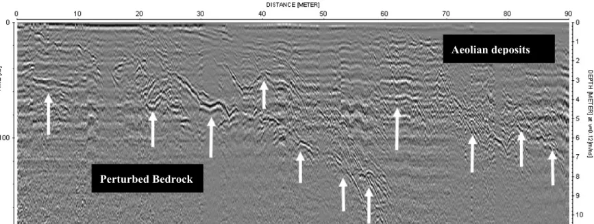
In the flat intercrater area, the 900-m-long profile (Fig. 1) showed shallow structural elements associated with potential evidences of the consequences of the shock effects in the bedrock, i.e., faulting, fractures, and chaotic bedrock (Fig. 4). While orbital and field observations in the intercrater area showed a very smooth surface, radargrams showed that
there was a significant lack of stratigraphy in the first 10 m of the subsurface over the entire study area: fractured bedrock has been observed as shown in Figure 4, a 90-m-long GPR segment extracted from the 900-m intercrater profile identified in Figure 1. The investigated depth was limited to a maximum of 10 m, which is lower than the instrument’s nominal performance for sandy soils, due to significant losses associated with scattering. We can clearly identify the perturbed and fractured bedrock, which is covered by a few-meter-thick layer of aeolian deposits. In particular, we can observe scatters with a typical hyperbolic shape, a characteristic of diffraction mechanisms that occur in the presence of fractures and heterogeneities with dimensions comparable to the radar wavelength in the ground. Data migration suggests that the observed diffraction patterns are from fractures and brecciated bedrock.
4. Implications for Sounding Radar on Mars
Our results suggest two major implications for shallow subsurface sounding in Martian cratered terrains at our frequency range. The first is the ability of GPR to identify small buried craters, as they play a fundamental role in dating surfaces and determining the environmental and chronological evolution of Mars [Plescia, 2005]. The 270 MHz GPR successfully probed the structural elements for the buried craters to a depth of more than 10 m and allowed to resolve the layering sequence constituting the crater filling. Both tasks can be easily achieved from a rover-mounted GPR. Therefore the lithology of the deposits that fill the craters can provide information about the climatic evolution of the study area. Tilted layering in the fill could be interpreted as aeolian sediments while parallel layers, if observed, can be associated with a fluvial filling process. Such sedimentation is already observed in high-resolution MOC
images in several mid-latitude Martian craters as previously mentioned for the impact crater (located at 0.9°S, 346.2°W) in the northwestern Schiaparelli Basin [Crane and Albin; 2002], which exhibits a clear view of layered, sedimentary deposit. Another interesting observation we made in the GKCF is the significant difference between the number of surface outcropping craters and buried craters identified using GPR profiles: In such an arid environment, wind erosion and sand deposits tend to lower the exposed crater rims and bury them under the surface, both of which processes are representative of the Martian environment. The GKCF then provides a unique analog site to evaluate the response of radar instruments in cratered terrains.
The second major result is the limitation of penetration depth caused by volume and multiple scattering due to the structural heterogeneity of the craters and their immediate surroundings. Despite the fact that the geoelectrical properties of the ground at Gilf Kebir are favorable to radar penetration (laboratory measured complex permittivity of 3.6 and a loss tangent of 0.004), we observed that the fractured and chaotic bedrock, a consequence of impacts, produces strong multiple and volume scattering that increases the signal attenuation and then reduces significantly the penetration depth to below the instrument’s nominal value. In the heavily cratered terrain of Mars, as well as other terrain that may contain buried craters, it is clear that volume and multiple scattering in the first few tens of meters will prove to be one of the most challenging issues for high and mid-frequency radar investigations. Future work will consider further multiple frequencies soundings with different survey geometries (truck mounted and airborne) to assess a realistic understanding of the performance of future radar experiments and potentially better interpret data from cratered terrains.
Acknowledgements. The authors would like to express their gratitude to GSSI and
EXI-Austin for providing the experimental radar system. This work has been supported through the NASA-MARSIS grant (provided through the participation of Dr. Stephen Clifford to this study), LPI2005-CAN, and the French ACI for Earth Observation. This paper is LPI contribution number 1277.
References
Berthelier, J. J., R. Ney, V. Ciarletti, A. Reineix, B. Martinat, M. Hamelin, F. Costard, et al. (2003), GPR, a ground-penetrating radar for the Netlander mission, Journal of Geophysical
Research (Planets), 108 (E4), pp. GDS 8-1, Cite ID 8027, DOI 10.1029/2002JE001866.
Buczkowski, D. L., H. V. Frey, J. H. Roark, and G. E. McGill (2005), Buried impact craters: A topographic analysis of quasi-circular depressions, Utopia Basin, Mars, Journal of
Geophysical Research, 110 (E3), Cite ID E03007, DOI 10.1029/2004JE002324.
Crane, A. N. and Albin, E. F. (2002), Distribution, Morphology, and origin of Layered Deposits within Schiaparelli Basin, Mars, DPS Meeting #34, American Astronomical Society, Vol. 34, p.866,
Garvin, J. B., B. A. Campbell, S. H. Zisk, G. G. Schaber, and C. Evans (1989), Radar scattering mechanisms within the meteor crater ejecta blanket: Geologic implications and relevance to Venus, In Lunar and Planetary Inst., Abstracts for the Venus Geoscience Tutorial and Venus Geologic Mapping Workshop p 19-20.
Grant, J. A., P. H. Schultz, and J. O. Campos-Enriquez (1995), Definition of shallow subsurface structure around the Chicxulub impact crater using Ground Penetrating Radar, Abstracts of the Lunar and Planetary Science Conference, volume 26, page 495.
Grant, J. A., C. J. Leuschen, A. E. Schutz and B. A. Campbell (2003), Ground-penetrating radar as a tool for probing the shallow subsurface of Mars, Journal of Geophysical
Research (Planets), 108 (E4), pp. GDS 5-1, Cite ID 8024, DOI 10.1029/2002JE001856.
Grant, J. A., T. A. Maxwell, A. K. Johnston, A. Kilani, and K. K. Williams (2004), Documenting drainage evolution in Bir Kiseiba, southern Egypt: constraints from ground penetrating radar and implications for Mars, Journal of Geophysical Research, 109(E9), Cite ID E09002, 10.1029/2003JE002232.
Greeley, R., P. R. Christensen, and J. McHone (1987), Radar characteristics of small craters — Implications for Venus, Earth Moon Planets, 37, 89–111.
Grimm, R., E. Heggy, S. Clifford, C. Dinwiddie (2005), Scattering Limits to Depth of Radar Investigation: Lessons from the Bishop Tuff, Workshop on Radar Investigations of Planetary and Terrestrial Environments, Houston, Texas, abstract no.6025.
Orosei, R., R. Bianchi, A. Coradini, S. Espinasse, C. Federico, A. Ferriccioni, A. I. Gavrishin (2003), Self-affine behavior of Martian topography at kilometer scale from Mars Orbiter Laser Altimeter data, Journal of Geophysical Research (Planets), 108 (E4), pp. GDS 4-1, Cite ID 8023, DOI 10.1029/2002JE001883.
Paillou, Ph., G. Grandjean, N. Baghdadi, E. Heggy, T. August-Bernex, and J. Achache (2003), Sub-surface imaging in central-southern Egypt using low frequency radar: Bir Safsaf revisited, IEEE Trans. Geos. Rem. Sens., 41, 1672.
Paillou, Ph., A. El Barkooky, A. Barakat, J.-M. Malézieux, B. Reynard, J. Dejax, and E. Heggy (2004), Discovery of the largest crater field on Earth in the Gilf Kebir region, Egypt, C. R.
Plaut, J. J. (2000), Small crater populations on Mars: Studies of MOC images, 31st Annual Lunar and Planetary Science Conference, Houston, Texas, abstract no. 2060.
Plescia, J. B. (2005), Small-diameter Martian craters: Applicability for chronology, 36th Annual Lunar and Planetary Science Conference, in League City, Texas, abstract no.2171
E. Heggy, Lunar and Planetary Institute, Houston, 3600 Bay Area Boulevard, 77058-1113, Texas, USA. (e-mail: [email protected])
P. Paillou, Observatoire Astronomique de Bordeaux, 2 rue de l'Observatoire, BP 89, 33270 Floirac, France.
Figure 1. A 10-m-resolution SPOT 4 mosaic of part of the Gilf Kebir Crater Field (GKCF).
The black arrow locates of the small-buried crater profiled in Figure 3. The 900 meters-long black line indicates the intercrater GPR profile location where a 90-m extracted portion is presented in Figure 4.
Figure 2. Comparison between the geomorphology of small Egyptian crater GKCF07 (upper)
and the Bonneville crater observed on Mars by the Spirit rover (lower; credit NASA/JPL). Both craters are comparable in size (85 m for GKCF07 and 190 m for the Bonneville crater) and are filled with aeolian sediments.
Figure 3. (a) Surface view of the outcropping portion of the GKCF28 crater. (b) The 270-MHz
GPR profile performed across the structure. (c) Idealized cross-sections of the structure of the small simple crater structure (modified from Koeberl and Sharpton, LPI Contribution No. 1083).
Figure 4. Extract of a radar-sounding profile along 90 m in the intercrater area. The white
arrows indicate hyperbolic diffraction patterns indicating the ground heterogeneities and fractures.
(a)
(b)
(c)
Figure 4
Perturbed Bedrock