.APPROACHES TO AIRPORT SITE LOCATION THROUGH STANDARD METHODOLOGIES AND APPLIED
DECISION ANALYSIS
by
Wayne Wesley Hill B.Arch., University
(1970)
of Oklahoma
SUBMITTED IN PARTIAL FULFILLMENT OF THE REQUIREMENTS FOR THE DEGREE OF
MASTERS OF ARCHITECTURE IN ADVANCED STUDIES
at the
MASSACHUSETTS INSTITUTE OF TECHNOLOGY June, 1972
Signature of Author...
Certified by....
Accepted by...
*0... 0...0000. ** ...
Departmpnt of /Architecture Environmental Design Program May 12, 1972
.. . . . ... Thesis
Sabervisor
Chailman, iepartmental Committee of ROtchGraduate Students
I. s LN T. rEC
DEC 1 2 1972
ABSTRACT
Transportation planning constitutes a comprehensive effort not only to formulate decisions to resolve existing transportation problems but also conditions that are to
arise at a latter date. Assuming that there no longer exists a set of monblithic techniques to be applied to the planning of a major transportation project; this thesis
offers a supportive argument for the use of applied decision analysis in airport site selection.
The urgent need of well planned airports capable of accommodating an ever increasing volume of annual aircraft operations has compelled several large urban centers to instigate searches for a second airport site and thereby
consider the air traffic node in regional terms. Methodologies most often employed in this type of investigation are reviewed with a summary of the report produced in search of a second major airport site for the Boston Metropolitan Area. This 1970 study relied upon what is termed in this thesis as the
standard methodologies in reaching the final recommendation. The second major part of the thesis is devoted to the explanation of decision theory basics. An example of an
airport site investigation using principles of applied decision analysis is presented here.
A discussion of the advantages, disadvantages and byproducts of the use of applied decision analysis in major transportation planning projects composes the concluding remarks.
ACKNOWLEDGEMENTS
I wish to thank the group of MIT faculty members that contributed in making the writing of this thesis something other than a required research venture. Developing this work has remained stimulating due to the challenging topic
and the generous giving of time and constructive criticisms from the faculty group.
I thank Professor Ralph L. Keeney of the Department of Civil Engineering whose work with applied decision
analysis has acted as a basis for my research. His
Mexico City Airport Study which is included in this work has been of special importance to the author through its indication of a more responsive look at transportation planning.
My appreciation is extended also to Professors Richard C. Larson and Ralph A Gakenhiemer, both of the Department of Urban Studies and Planning,for their time
and suggestions.
Professor Nigel Wilson of the Department of Civil Engineering has played a very important role in the
[3]
sharing with me the "growing pains" of my working with transportation planning for the past two years, he has become to the author both a highly respected critic and friend. To him I am deeply indebted.
To Professor Julian Beinart, Department of Architecture, I express special appreciation for his effort in the
execution of this work. His ability to provoke new directions and paths of investigation on this topic was helpful throughout the writing of this thesis, and his optimism aided the author in some of the more vexing periods of research.
A constant focus of my indebtedness has been my
editorial assistant, B. L. Naifeh, whose encouragement will continue to amaze the author.
TABLE OF CONTENTS TITLE PAGE ACKNOWLEDGEMENTS TABLE OF CONTENTS LIST OF FIGURES PREFACE
Chapter One: THE STANDARD METHODOLOGIES
1.0. Introduction...11
1.1. Definition of the Designer...12
1.2. Task of the Designer... ... 13
2.0. Presentation of the Problem...-15
2.1. The Growth and Effects of the Airport. ... 16
2.2. Point of Departure ... 17
3.0. Survey of Techniques and Methodologies...18
3.1. Inventory of Existing Conditions ... 20
3.1.1. Survey of Physical Conditions...20
3.1.1.1. Land Use Inventory...21
3.1.1.2.
Population Inventory...233.1.1.3. Inventory of Transportation Facilities. .26 3.1.2. Survey of Area Dynamics...29
3.1.2.1. Trip Generation...29
3.1.2.2. Inventory of Available Monetary Conditions .. ... .34
3.2. Estimates of Future Urban Area Growth... 35
3.2.1. Population Forecasts ...
35
[53
,3.2.2. Future Economic Activity... 3.2.3. Future Land Use... 4.0. Example of Airport Study Using the Standard
Methodologies... Figure I-B...
Chapter Two: APPLIED DECISION ANALYSIS 5.0 Introduction...
5.1. Application toThesis... 5.2. Preface to Decision Analysis Review.. 6.0. Survey of Decision Analysis Components...
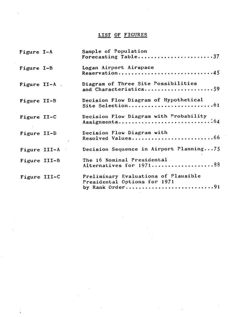
6.1. Utility Theory... Figure II-A. ... 6.2. Decision Flow Diagrams... Figure II-B. ... 6.3. Probability Assignment...
Figure II-C. ...
Figure II-D. ...
Chapter Three: DECISION ANALYSIS APPLIED TO AIRPORT DEVELOPMENT
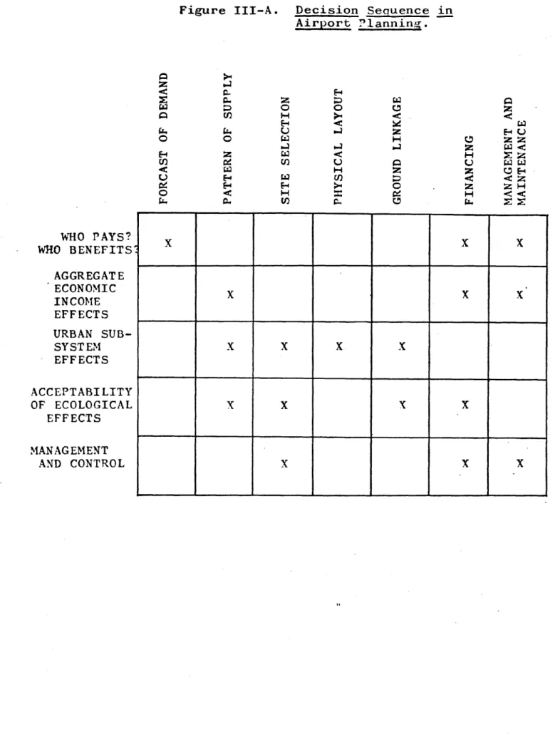
7.0. Decision Analysis and Large-Scale Planning. 8.0. Analytic Models and Airport Planning... 8.1. Related Airport Planning Issues... Figure III-A. ... 8.2. Example of Decision Analysis as Used
Airport Site Location... 8.2.1. The Problem... 8.2.2. The Situation... 8.2.2.1. Physical... 8.2.2.2. Institutional... 8.2.3. The Analytic Approach... 8.2.4. The Static Model...
... 38
...
40
... ... 42...
45
.49
.50
.51
.52
.56
.59
.58
.61
.62
.64
.66
... 67 72 72 ...75
0
r...
76
...
77
...
78
...
.78
...
80
...
82
...
82
f.
.
.
-....
....
8.2.5. Results of the Static Model...85
8.2.6. The Dynamic Model...86
Figure III-B. ... 88
Figure III-C. ... 91
Chapter Four: IMPLICATIONS OF DECISION ANALYSIS USE 9.0. The Future of Airport Site Selection Studies...93
9.1. The Changing Role of Methodologies...94
9.2. Expected Gains from Decision Analysis Use..95
10.0. Limitations of Decision Analysis...99
11.0. Redefinition of the Designer...103
12.0. Concluding Remarks...107
[7]
LIST OF FIGURES Figure I-A Figure I-B Figure II-A Figure II-B Figure II-C Figure II-D Figure Figure III-A III-B Figure III-C Sample of Population Forecasting Table... Logan Airport AirspaceReservation... Diagram of Three Site Possibilities and Characteristics... Decision Flow Diagram of Hypothetical Site Selection... Decision Flow Diagram with Probability Assignments... Decision Flow Diagram with
Resolved Values... Decision Sequence in Airport Planning.. The 16 Nominal Presidental
Alternatives for 1971... Preliminary Evaluations of Plausible Presidental Options for 1971
by Rank Order...
.37
.45
.59
.61
.64
.66
.75
.88
.91design phase. Dependent upon this initial approach taken is both the responsiveness of the planning solution to present conditions as well as its ultimate success in the accommodation of future demands. The designer has a
difficult job involving his familiarization with present needs, which support the designing of a transportation
improvement, and working with time factors, which represent a gap between the designing stage and actual time of
implementation. In viewing this situation, the author has pursued an answer to the question: In a densely settled urban environment with established patterns of movement such as those now existing in the Boston area, how are effective changes in urban transportation decided upon and how do they get implemented?
Part of the answer to this question has been found in the capabilities of the methodologies available to the
designer. To further the answering of this first question, the author attempts through this thesis to answer another
[9]
question pertaining to the approach that may be assumed by the transportation designer. The issue to be confronted
in this work is based on the examination of whether a planner's design becomes more responsive, more corrective toward the apparent need through an approach which includes basic decision theory analysis components than with a
package of monolithic prediction techniques alone.
The posing of this issue was made after the author
had worked with the most commonly used prediction techniques which shall be referred to throughout this work as the
standard methodologies. In the study of these methodologies an incongrous characteristic between the formal methods of predictions and the growth and change of the urban
environment became apparent. With the products resulting from these techniques came a large investment of the design
input dealing with prediction from one point in time with little mention of sequential or continuing design. Large scale
facilities are designed at one point and years later, after construction, implementation occurs to respond to the
expected shift in demand. The shift in demand, future demand, having been calculated in the design stage. This approach to transportation planning seems very limited as
-it usually is executed, and -it is often proven to be so by transportation facilities being obsolete upon their implementation.
As a result, this thesis represents a foundation to an arguement,for a more contingent planning approach to transportation planning through review of the benefits of decision analysis.
[i1
APPROACHES TO AIRPORT SITE SELECTION THROUGH STANDARD METHODOLOGIES AND APPLIED
DECISION ANALYSIS
Chapter One: The Standard Methodologies
1.0 Examination of the complexities of the design and implementation of any proposed major transportation
facility to be inserted into the urban environment has to begin with the definition of the roles of the
maker and the set of tools available to him in his decision-making process. The set of available- tools or methodologies fall within two broad categories; 1) the standard methodologies which include assessment of existing conditions and the
formal prediction of future demand , and 2) innovative techniques which would include applied decision analysis. Both of these categories will be reviewed in this work with discussion of their basic concepts, examples of their use and finally conclusions as to their use in airport planning. Planning or comprehensive airport strategy will be considered a flexible process here with the contributions of various methodologies due to alter and vary with each separate airport study. Also, definition of the decision maker will be presented in light of the methodologies used.
Successful design of a major activity node such as an airport is greatly dependent upon the study of the urban system from a comprehensive viewpoint. It is the
understanding of the over-all workings of movement patterns, analysis of surrounding land use and the like that presents the greatest challenge to the decision maker. This
challenge is considered by the author to be increasing in magnitude and it will be the purpose of this thesis to give
insight into the methods of examining the urban system that are now available by use of the standard methodologies and applied decision analysis.
1.1 Deciding who is the principle decision maker is an uncertain issue in urban planning today. The desire for a solution based upon comprehensive research into the
workings of the urban environment has led to the inclusion of a small set of professionals from varying backgrounds,
among these engineers, architects, and planners. While each of these roles can be justified as valid contributors to the shaping of the urban environment, specific areas of airport site selection are restricted from one or more of these assorted professionals due to their background. For example, architects, who usually work at a smaller
[13]
scale than the transportation engineer, lack the expertise to deal with trip generation studies. The issues involved in an airport study are so complex and numerous that total contribution of all these differing professionals cannot be accommodated by the investigative methodologies most
commonly used. However, it would be to the benefit of a solution that none of these disciplines be excluded from the design team. In order to avoid favoring one of these disciplines over another, the decision maker referred to in this thesis will be termed "designer." The designer will represent a person or persons organized into a team or
council who addresses an urban problem and is responsible for the evaluation of data in order to produce a recommendation.
1.2 The designer holds the two-purpose position of evaluator and prescriber of environmental changes which may result from the implementation of a new transportation
facility. The evaluations of the designer are a function of his methods of data collection and interpretations, and lay the foundations for his predictions. The quality of the product of his study is the. result of the sophistication
and use of his methodologies and prediction techniques which illustrate his approach to the solution of an urban
transportation problem. It remains his task to consider such issues as for whom is the facility being designed; what are the goals and objectives of the area; what are the effects of his solution; what is the ranking of the
differing alternatives; and how reliable are his techniques. In addition, other related social, economic, and environ-mental factors should be dealt with through the designer's study techniques. As these factors tend to increase in number and importance, his means to evaluate these factors, as affected by the proposed airport, should respond. There
are limitations of the methodologies used- Therefore, it also becomes the task of the designer to improve the
techniques he employs in his design approach to accommodate the changing number and character of the related factors.
The designer will also assume the task of making
recommendations and site selections which will be tested in the future. In addition to dealing with an array of peripheral
factors and multiple objectives, he is compelled to look ahead to the conditions of a future time in his design process. The use and interpretation of his techniques will determine the accuracy of his prediction of uncertain
[15]
recommendation.
The job of the designer changes in respect to the
changing issues surrounding the formulation of an airport
strategy and the success of his solution becomes dependent
upon the products of the methods used. Ways in which the
designer can meet the altering of his techniques through
incorporation of decision analysis will be suggested in
later text.
2.0
The design of a major transportation facility
affects many of the components of the urban environment.
The contribution of the facility to the resolution of the
study region's transportation problems is dependent upon
economic, social and physical features as well as
institutional influences. The corresponding measure of
effectiveness of the new facility is gauged from the
efficiency of movement in and around the urban domain
that it provides. An example of a transportation facility
that generates far-reaching effects is the urban airport.
This type of transportation facility was chosen to be
reviewed in this thesis because:
1) it represents a large
activity node occurring at the point of interchange of
ground and air transit and 2) since it is a point situation
and would require one site rather than a continuing space,
such as with a highway, it was thought to lend itself to the short time period (four months) of the development of this thesis.
2.1 It is evident that with the development of air travel a new dimension to travel has become available to increasing numbers of users while at the same time
affecting, through location and operational functions, an increasing number of non-users. Air travel has the advantage of reducing travel time, but it has brought with it a new set of problems for urban life. Today, air travel, from airport to airport, is far more advanced in speed and comfort than ground travel to and from the airport. It is the air terminal that acts as the principle point of interchange between air transportation and
ground transportation. The efficiency of the interchange is, in part, determined by the location of the airport in relation to the urban area it serves.
The airport has been considered both a desirable and undesirable part of the urban environment because it makes a good neighbor to a very limited set of land uses. Airports have not only grown in size since the days when an airport required a small field on which to operate, but it
[17]
has grown in intensity of use to a point where it is an active urban sub-system--a city within a city. The changing character of the airport has brought greater difficulty in selection of its site. Usually, the
airport is already well-established in the city; its site having been selected at a past time when airport site location was a relatively simple matter. However, due to increased use of air travel, many of these airports
are reaching capacity calling for the establishment of a revised airport planning strategy. This usually includes search for a new airport site.
2.2 The study of optimal airport location is in itself a broad and complex topic. It may include considerations relevant to varying types of air transportation, such as general aviation (private planes), military aviation, and long-haul air transport. This thesis will focus upon the challenge of investigating site possibilities for a
second major airport in an urban area.- This type of investigation has recently become more widespread as major metropolitan areas launch inventories of possible sites for a second major airport in their regions as the demand upon their present airport facility reaches its
maximum capacity.
Airport site selection requires the comparison of the associated advantages and disadvantages arising from the selection of one site from a range of possible sites. The search for asecond major site location becomes a particularly complicated problem since there rarely exists a site that will not cause some degree of disruption to urban life through
displacement or noise. At the same time, the designer must locate the new airport as close as possible to the potential market area of the region.
3.0
The techniques and methodologies used in transportation design increase in complexity and scope as each responds to the transportation problems' urgency. The standardmethodologies used in transportation design,such as those that will be later reviewed, tend to examine and formulate
recommendations from a comprehensive systems approach with careful study of existing conditions employed as a
background for speculation as to the design's success. Each transportation study has developed its own pattern of examination in order to produce its own package of design recommendation. Proof of one technique being superior to others remains unestablished to date. Brian Martin remarks on the condition of the differing design studies by saying;
[191
"The urgency of the problem has left little time for objective evaluations of the techniques presently available, since each
new study creates new sets of principles and techniques."' The field of formulating design models to respond to the
problems in urban transportation today remains and open-ended one with refinements in the process of problem definition and solution still being contributed. As is usually the case, each transportation study acquires an individualism through the specific sets of conditions and differences of the characteristics of the area examine, but most studies use as a foundation one or several of the
techniques relied upon by previous designers. In this first section a review of this group of techniques is examined to act as a foundation to the approach of the specific problem of urban airport location dealt with in
this thesis. This review will not attempt to be all-inclusive of the latest developments in transportation design
techniques, but rather it is presented here to provide a rudimentary insight into the principles and techniques most commonly found in specific transportation studies of future airport location.
1 Brian V. Martin, Frederick W. Memmott, and Alexander J. Bone, Principles and Techniques of Predicting Future Demand
for Urban Area Transportation, M. I. T.Report No.
3
3.1 By recommending transportation improvements that can
only be evaluated in the future, the designer has found
value in a careful examination of past and present conditions of the area being studies. Conditions of the region such as land use and topography are necessary in the establishment of one location over another. Further study of existing
conditions would include the dynamics of the land, specifically, the trip generation properties and existing networks of
movement patterns. Familiarization of these existing
conditions is sought in order to provide the designer with a frame of reference in which he might better formulate his design projections.
3.1.1 In a study of airport location, the establishment of the physical conditions of a group of site possibilities has great importance in matching the design requirements of an airport to the existing conditions. Through study of such physical conditions as land use, population, and inventory of existing transportation facilities the
designer can construct a procedure of ranking one site over another through a comparative study of displacement,
development costs and potential conflicts in the operation of the airport.
[21]
3.1.1.1
An inventory of land use can provide the
designer with a means of measuring the relationship of land
use to trip generation. Ideally, the airport should be
located in an area of compatible land use and have a good
relationship to center of trip generation. That is,
interacting relationships between travel characteristics
and the surrounding environment. Because the new airport
will create large impacts on existing conditions, the
decision to build and, to a like extent, the possibility of
an airport being built in the area cannot help but alter not
only the specific land parcel used for the airport but
surrounding parcels as well.
It becomes very important
to develop a strategy to locate the airport on a site
which makes the most positive contribution to the urban
life
by being located in an area of compatible land use and
which is in prime relation to sources of trip generation.
A comprehensive land use inventory would include breakdowns
of the sites, kinds of activities, intensity of useage, and
properties of accessibility. Land use surveys have become
important tools in the prescription of the location of
future establishments.
The procedure of making an inventory of site activities consists of a division of the region of possible airport location. This would include the site itself as well as a share of the surrounding properties. The region is broken down into zones whose incremental size varies with each study. A classification of activities is developed which might include categories of residential, industrial,
and other uses. Each zone is then distinguished from
others through the identification of the'existing category of activity. The product is a diagramatic mapping
showing the juxtaposition of the varying types of
activities in the study region. The mapping is important to airport location because industrial areas have proven to be compatible neighbors to the airport providing an
efficient cluster activity of air transport to certain manufacturing and distribution concerns. In addition, the
location of the airport site in relation to residential activities has become crucially important since it is not the intent of the designer to force out this land use from
the region. The site activity inventory acts as an
important input in the selection of the airport site since it can give indication that the future development of the
[231
study region is more apt to follow a certain path of development, say residential, without the development of
an airport. This gives the designer some indication that the building of the airport could bring about potential conflicts in land use.
The intensity of urban land useages is an important companion to the land use inventory since the relative intensities of land useage do not appear on the first mapping. Intensity of land useage provides the designer with indications of sources of trip generation since high intensity of useage is associated.with origin and destination points of trip generation. The land use intensity study
uses the mapping system of the land use inventory as well as the activity categories. Exacting measurement is
made through the comparison of either total building floor area to the site area or the total zonal floor area to the zonal land area. Transportation studies for improvements other than airports such as highways or mass transportation routes rely heavily upon the matching of the improvement with determined points of high trip generation. This is not the case in an airport location study. Building an airport in the nearest area of high intensity land use,
such as the CBD, is not always possible and rarely considered feasible. Several designs have been developed, however,
which put the airport near the CBD. The obvious advantage
of having the facility so close to a source of high intensity--therefore, and important node of trip generation--has often
been dismissed. It is not an optimal situation due to the high development cost such as of floating airports, the compounding of congestion and environmental characteristics in the urban hub and the insoluble conflicts the operation of an "in-town" airport might raise with existing airports in operation. Conversely, the intensity map is useful to the airport designer as a means of determining accessibility and spatial relationships to the proposed airport site.
The determination of land use patterns is the third
part of the inventorying of existing physical conditions that aids the designer in his selection of the preferred airport location. While the two previously performed mapping
studies could be described as being a fine-grain illustration of existing conditions, the land use patterns study is a
coarse-grain illustration of the structuring of the surrounding land around the point of hishest intensity, the CBD.
[25]
Land use patterns, having origins in the historical development of the urban area, and growth, having been determined by developed routes of the movement network,
give the designer a chronological picture of the development of the region. This picture of past development is important in the selection of the most appropriate airport location through the delineation of the major movement arteries in the region. The success of the second airport's location is
judged, in part, by its accessibility to users. Accessibility, in this case, usually is a function of the efficiency of
ground travel to the airport. The land use patterns indicate to the designer the degrees of accessibility of each site under consideration.
3.1.1.2 Population inventory of the study area accounts for another means for the designer to weigh the advantages of one site over another for purposes of airport location.
Unlike the results of population inventories taken for transportation studies other than that concerned with airport location, the airport designer employs the results of such an inventory for purposes of estimating the numbers of persons who would actually be displaced by an airport
pro-perties. In studies involved with highway design, population inventories act as the first stem in the estimation of
residential trip generation. This contrasts with the
purposes of the inventory for the airport designer,since it is not the residential trip generations in and around the study area that constitute the area of market potential of the airport. In terms of displacement, the population inventory would be recorded in terms of numbers of persons
residing per unit area such as net or gross area, etc. Population patterns show degrees of intensity inversely
proportional to the distance from the CBD.
3.1.1.3 The past methods of investigation have made it possible for the designer to familiarize himself with the set of properties that each site has. Consider the
product of these past inventories as a descriptive map upon which is to be superimposed the fabric of the area's
transportation system. This network represents the
supply side of the picture with the previous inventories giving indication of an emerging demand. The capacity of the study region to supply a means to allieviate the
transportation situation can be determined through an inventory of its existing transportation facilities.
[271
Existing transportation facilities that could be directly incorporated into the area's air transportation system are established as possible sites. These are usually found to be existing military air fields or general aviation fields which could possibly be expanded to adapt to the use of a
second major airport in the region. With major movement patterns delineated in the land use pattern inventory, locations of
existing mass transit facilities are important to locate in order to study the possibility of points of modal change, i. e. air to ground transportation. Such studies are essential in the estimation of the development costs at each site, since it is usually necessary to improve through construction or alteration of the connecting links--highways and/or mass transit routes, to provide better accessibility between the airport and points within the potential market area. This is particularly important in the establishment of an efficient connector between the airport and the CBD. In the formulation of the design of improvements of
existing ground transportation facilities, capacity is
determined through the ability of the existing arterials and expressways to carry vehicles expressed by quantitative
measure. Capacity is here studied in two cases; basic capacity, which is a theoretical number of vehicles that
can pass a point under the prevailing roadway and traffic conditions, and practical capacity, which is less than possible capacity and is intended to introduce a "quality of service" into the definition of capacity. It is these studies of ground transportation capacity, especially automotive travel, that will indicate development costs necessary to provide access to each site. Since this type of improvement represents a large sector of the
development budget, it is an important means of judging one site over another.
An inventory of existing mass transit facilities includes notation of equipment used, and schedules and routes of all forms of public transportation used in the area. Extensions of existing public transportation systems to accomodate the demand brought about by the building of an airport
contributes another consideration in the total development budget. In the case of rapid transit, extension of routes represents an enormous expenditure of millions of dollars per mile extended. Advantages of a site near or along the existing route of the public transportation system would give basis for its selection over those further away and less associated with the existing transportation facilities.
[291
Examination of the existing transportation facilities is
paramount in the use of the systems approach to the question
of airport location.
3.1.2
The study of the dynamics of the area is necessary
for the completion of the investigation of existing
characteristics present in the area under study. With the
data concerned with the physical components of the available
sites (as produced from the previous techniques discussed),
the study of the area dynamics helps complete the range of
information required to assess the present and potential
movement patterns. Included also as a dynamic aspect is the
availability of monetary sources.
3.1.2.1
Trip generation is the study of the interacting
relationships between travel characteristics and the
surrounding urban environment. As such it represents an
important means for the designer to familiarize himself with
the existing nature and pattern of the study region's
movement system. The trip generation study is one of
several processes used by the designer as he faces the
problem of predicting travel movement in the area under
generation is usually found to be the first step in
the travel forecasting process to be followed by studies of modal split, trip distribution, calculation of volume/capacity ratio, and others. As the initial step in travel-forecasting, trip generation represents a major input into the design
process and eventual site selection, since it is his task to present arguements for his preferred site in respect
to the expected patterns of movement in the urban environment. Determination of trip generation is most simply an
approach through a geographical-representation of trip
origins and destinations. This, in turn, becomes a graphic summary of the major points which define the movement pattern.
Taking the established points which represent the origin and destination of the trips in the region, a
connecting line is drawn representing the route between the origin and destination pairs. Known as the disire line
plot, the straight lines (airline distances) map out the maze of movement in the urban area. Zones are established in the diagram as means of consolodating trip volumes at origins and destinations. "The number of trips generated and attracted by each zone are calculated and, in
[31]1
from travel conditions or the price of travel and with empirical observations of existing trip-generation rates being used."2 The information provided from this simple geographical representation is by itself too general to be of great use by the designer. One of the major way in which this method limits itself is by having the connecting line between points of origin and destination expressed by a straight line disregarding actual ground routes, i. e. streets. "Stratification of travel provides a better means for representing and studying the effect which different social, economic, and physical factors have on person and vehicular travel." Elements producing the
categorical breakdown of the area's travel, the stratification, include family income, vehicle ownership, trip length, land use density, time of day, and others. These are, in fact, variables providing circumstances which affect the number and nature of those trips found in the study region.
Some of the variables incorporated in the trip
generation study may be categorized as social characteristics of the region's travel. For example, trip purpose may be considered a social characteristic of travel and is the most
2 Martin Wohl and Brian V. Martin, Traffic Systems Analysis for Fngineers and Planners (New York, N.Y.: McGraw-Hill, 1967), p. 128.
often recognized stratifier of travel. In addition,
family income stratifies travel and reveals increasing
family income leading to greater trip production. Also,
the social characteristic of vehicle ownership is influenced
by factors such as family income, population density, and
distance from the CBD.
"Increasing vehicle ownership
increases trip generation." 4
The land use surveys described previously play an
important part in the study of physical characteristics
of travel. Land use becomes a means to classify and study
trip generation activities and is of particular importance
in resolving a correlation of residential densities and
the number of person and vehicle trips per dwelling unit.
As produced from studies of land use at origin, increasing
residential density decreases the number of person and
vehicular trips per dwelling unit. This type of
information is useful to the designer by noteing the
potential market area for the second airport and showing
the type and number of trips in the region. This information
is expanded through the continued study of other physical
characteristics, such as distance from the CBD, length of
trip, mode of travel, automobile occupancy, and land use
[331
destination.
Often the information derived from these variables is
difficult to correlate in the production of a conclusion
that would describe to the designer actual trends or
characteristics in the region's travel pattern. In this
case, mathematical devices are used to produce correlation
coefficients which lead to the determination of those
variables which are independent or are acting together.
Other means of estimating resident trip generation may be used.
A series of trip generation relationships (either
algebraic equations or graphical plots), with one
relationship for each possible combination of the...
variables, would be necessary to cover all possibilities
...This represents trip generation sufficiently detailed
and refined for obtaining a precise answer, while
retaining simplicity necessary in the practical
application to the transportation planning process.
Estimation of future trip generation characteristics
can provide the designer with yet another criterion, since
it would be to the advantage of the airport to found
strong relationships to principle point of trip generation.
This is important at a city scale in the serving of the identified
area of
market potential--also at a regional scale with
the
service
of regional air transport needs by the second
airport location.
3.1.2.2
Fiscal resourses related to development of a
second urban airport represent influential factors in
terms of the actual implementation and scope of the
proposed sirport. It is the expected task of this survey
to determine the total capital currently available for
expenditure on the research and development of the second
air facility. "Arriving at an estimate of capital resources
to be made available in the future usually causes assumptions
to be made that would predict that current tax rates will be
raised, construction costs will iicrease, no change in the
availability or apportioning of federal aid will occur and
no increased borrowing will be contemplated."
6The
allowable development costs of the second airport which
would include expenditures on reinforcing paths of access
to the airport site by highway or mass transit is defined by
the restrictions of available monetary resources. This line
of thinking is bound to point out certain advantages of one
site over the others. Investigation into future available
fiscal resources indicates the allowable expansion of the
airport in the future and the capacity of a site to
accommodate this future expansion would act as a strong
point of comparison with the capacity of the other sites.
[351
3.2
To this point, the designer has been concerned with
collection of data that describes to him the conditions that
presently exist. This data is useful as a tool to show
growth and development of the study region from the past up
to the present point in time. It also notates specific
physical and dynamic conditions that will aid him in his
study of each examined site and ultimately lead to his final
site selection. Studies of future urban growth have as
prerequisites the previously collected data on existing
conditions. In fact, they act as a foundation for the
projections made by the designer.
Ideally, the proposed
airport will be congruent to the urban environment, not only
at the time it goes into operation, but also in future times.
Antiscipation of these future conditions is founded in
methodologies dealing with population forecasts, future economic
activity and future land use.
3.2.1
Growth in population determines "the growth in
urban area economic activity, the requirements for additional
or new land uses, and the future levels of transportation
demand. 7 Since population does not grow consistently and
evenly in the study region, it is important to find the areas
of the most likely increase in population. This becomes particularly important to the airport location by giving an
idea of any potential conflict in land use and intensity which may lead to the effects the airport might have in the
future on the normal pattern of urban development. One method of population forecasting is through examination of known estimates for specified years of population of large political jurisdictions, or census
reports on standard metropolitan areas. These are usually found to be the most accurate. From this data a table can be constructed listing years in chronological order with matching population counts (Figure I-A). To this table, is
added official estimates of future population for--ideally matching--specified years. From the table, an incremental unit of population growth is interpolated by calculating
the past ratio of growth and prediction of a future ratio between the unknown unit population estimate and the next larger population unit. This method can be applied to
several scales; national, state, and city. The construction of a means to approxiamte the quantity and location of the
area most likely to grow in population is important to the selection of the airport location since the site possibilities usually lie outside the CBD in the suburban areas which are
Historical Population Growth for the U.S., State(Illinois), Metropolitan Area (Cook, DuPage, Kane Lake, and Will Counties in Illinois, Lake County in Indiana), Transportatioy Study Area (Chicago Area Transportation Study), and Central City (Chico)
U.S. State Metropolitan Area(Cook, Transportation Study Central City (Contin- (Illin- Kane Lake, and Will Area(Chicago Area (Chicago) Year ental) ois) Counties in Illinois, Transportation Study)
(000) (000) Lake County in Indiana
Popula- Percent of Popula- Percent of Next Popula Percent of Ne, tion(oo)) Next Larger t-ion Larger Popula- tion Larger Popula.
Population Ur it (000) tion Unit (000) tion Unit
19T .75995 4,822 2,092 43.4 1,699
1910
91,972
5,639
2,753
48.8
2,185
1920 105,71i 6,485 3,522 54.3 2,702 1930 122,775 7,631 4,676 61.3 4,086 87.4 3,376 82.6 1940 131,669 7,897 4,826 61.1 4,175 86.5 3,397 81.4 1950 150,669 8,712 5,495 63.1 4,677 85.1 3,621 77.4 1960 179,226 10,000 1970 212,910 11,6021980
259,081 13,775
9,500
69.0
7,802
82.1
3,650
46.8
GrowthRate
72.0%
58.1%
72.9%
66.8%
0.8%
1950-1980ISee
Chicago Area Transportation Study, Final Report, Data Projections, (July 1960), pp. 113-14.Vol. II: ct '* 0
l
(A 0. C11apt to show the most marked increase in population. There exists a degree of uncertainty in forecasting future
population growth. The uncertainty,stemming largely from the interpolation performed, as well as from unforseen future affects upon the population of an area,is offset by the long implementation time characteristic of a
transportation facility. Construction rates may be retarded or advanced according to the experienced rates of population increase. This would imply that sequential planning may be affected, and modifications made to the transportation facility plans,during-later years, as deemed necessary by urban population growth.8
Population forecasts represent an effort to coordinate the development and expansion of the airport with the
number and points of location of future population growth.
3.2.2 Forecasting the growth of economic activity in the study area aids the transportation planner in the determination of the future urban land requirements and indicates future trip generation characteristics. The forecast acts as an indication of the effects that will occur within the study region brought on by the expected
[391
increase in wealth of the urban area and. the consummer. In respect to airport site location, such a forecast could provide insight into the stability of the region which is
expected to provide the airport with its major sector of market potential. The forecast will also give an indication to the location of future market potential areas. It is
essential that estimates of future employment and per capita incomes be included in the forecast which would produce
insight as to the changing requirements and production patterns among industries, industrial and commercial employment and productivity.
There are several methods which can be employed to
produce a forecast of future economic activity, the simplest being the establishment of a ratio between future employment
and population. This ratio is produced from figures representing present employment and population. One of the most
accepted mthod of constructing this type of forecast is the input-output model which distinquishes three forces initiating change. These are growth in population and
productivity and changes in the urban area's trade with the outside economy. Future trade is projected on the basis of the trade estimates for the past years. With the
employment estimates for the future determination by the designer of future residential and industrial development
are produced. This would be important in the assessment of the advantages of one possible airport site over others
since it would benefit the airport to locate in close relation to industrial centers and avoid location near projected areas of residential use.
3.2.3 Forecasting future land use is intended to provide a representation of the composition of the future urban environment. It is necessary in the production of such a forecast that the kind of activity in the area, intensity of site useage, and location of future land use be considered. Preparation of the forecast would require a complete and accurate inventory of present land uses, estimates of future population, and estimates of urban area growth. Four main forces affect land development patterns. They are: 1) topography, 2) population, 3) building costs and, 4) the level (quality) of service that .will be supplied by the future transportation network. These four factors apply directly to airport location since they represent prime points of judgement of one site over another. Topography would affect development costs and indicate suitability of a site for the second airport development.
[411
Population would define future land use conflicts, such as the airport as neighbor to future residential locations.
Accessibility is important in determining future land use. Several formulae have been devised to describe
accessibility in relation to future land use. A simple assessment of accessibility is provided in the study of measurements of interzonal distance in the urban area with distance being measured in terms of airline distance,
ground distance or time. A more comprehensive index of
accessibility is found in the use-of the ratio of population over distance. In the examination of the expected changes in the future land use several factors that mold the
changes have become evident and are to be considered in the forecast. Statistically based tools such as
population forecasts and land use inventories should be included in the construction of the future land use study along with prediction of future economic activity, future trip generation, and land policy decisions. Since the future land use study includes predictions of future movement within the composition of the study region, it acts as a basis of the airport site selection criteria.
4.0 A study under the Boston Metropolitan Area
Planning Council was executed in the summer of 1970. The Council addressed the problem of the establishment of a
criteria for Boston's future air system development and concentrated upon the formulation of a development
strategy for the twenty-year period, 1970-1990. Being forced into making an effort to examine how the local air system could expand by the single major air site, Logan Airport, fast reaching maximum capacity, the
Council began an investigation for an appropriate site, as well as a justification for, a second airport in the Boston metropolitan area. "The Technical Committee agreed and recommended that it is now the time for the Commonwealth of Massachusetts to identify and reserve an appropriate second airport site to serve the eastern Massachusetts region."?9
The study, as executed, is an example of the use of a highly technical methodology, since the data collected stemmed from the methodologies previously discussed.
There were several factors that led to the study. The situation existing in Boston had indicated that some plan for airport development was required to
accommodate the predicted growth in aircraft operations
9 Metropolitan Area Planning Council, Staff Report Boston Metropolitan Airport System 1970-1990, (Boston Massachusetts: July, 1969), p. 56.
[43
J
during the 1970-1990 time span. These conditions were summarized as being:
1) Logan cannot be modified to accomodate an annual aircraft volume in excess of 300,000 operations,
2) No new competitive transportation system (e.g. VSTOL or high speed ground transport) would be developed for passenger use in the
forecast period,
3)
General aviation will grow at Logan without economic and/or regulatory inhibition.At the outset of the study, the Council established a site selection criteria to be applied to the six sites that were under review. The criteria was used to evaluate the transportation, economic, and social feasibility of the various sites. Points of their criteria were:
1) Market potential realization (maximum service to the air market and accessibility),
2) Air traffic control (air space compatibility),
3)
Social impact (compatible land use). 4) Engineering design and development costsThe six sites under review were presented as
likely candidates for second airport use. These were: 1) Dover, 2) Hopkinton-East,
3)
Otis Air Force Base, 4) Plymouth,5)
Sharon-East, and 6) Uxbridge-Douglas.None of these sites are located in the air reservation space of Logan (Figure I-B). The area confined within the
rectangle covering the area of densest settlement in Boston represented the air space required for the aircraft operation of Logan. Any site located within this rectangle was not considered since a second airport located in such close proximity to the existing major airport would cause operational conflicts as mentioned in the second point of the site selection criteria.
The first point of the criteria, market potential, was examined in terms of air trip origins. Here, trip
generation studies were used to determine the center of the air travel market in eastern Massachusetts. Trip purpose
studies concluded that the maximum market potential area fell within Route 128, with potential market growth
happening in southwest, south, and southeast sectors beyond Route 128. Exacting definitions of the
[451
Figure I-B.
/
Logan Airport Airspace Reservation. -/ B 0 S T 0
K
* . Hopkinton Dover \ V Sharon - Uxbridge Plymouth 0 5 10 scale in milesI- LOGAN AIRSPACE RESERVATION
9
a
evaluation of each site in terms of marketability. "Marketability and accessibility defines the volume of potential users of a new major air carrier facility and determines the degree to which the facility can financially support the capital and operating costs that would be
incurred."1 0 The air travel original destination studies gave considerations of ground access travel time and distance traveled between the proposed airport and air traveler
origin and destination. This was a particularly
critical establishment of expected volume of total airline passenger trips. Data collected from the trip generation
studies were illustrative in prediction of cost of access to the sites. This prediction represented the cost of the
right-of-way and construction from the regional highway facilities to the airport boundary. It was considered as
a direct cost applicable to the capital outlay of the airport. Air traffic control is a measure of the capability of a site to accommodate a specified level of aircraft
operation in an operationally safe and efficient manner within the context of an area's total airport system.
Location of the second airport should avoid aircraft operational conflict with other important existing, or
[47]
planned, airports within the total system. To produce an indication of each site's air traffic control potential, the FAA investigated all of the sites from an air
traffic point of view by employing an analysis based upon accommodating the maximum number of aircraft operations with minimum intervals between aircraft arrival and aircraft departures.
Land use studies were used to estimate the social impact of the airport's implementation. Social impacts, as gauged by land use activities, were considered in terms of the large land areas that would be consumed and the effect of the noise on existing land uses such as
residential and educational. The Council was aware of "the possible human hardships that would be implicit in the acquisition of dwelling units, institutions and
business firms and relocation of persons, activities and jobs that would be required."1 Social impact of the second airport was studied through cost/benefit analysis with cost being expressed in terms of land acquisition, access highways, rapid transit extentions and other costs relating to physical development of the airport. Benefit was primarily translated into terms of minimum displacement.
Familiarization with future land use patterns, future economic activity, and available monetary resources produced various strategies for development of the airport. Observations were made in view of rapidly
disappearing undeveloped land located within a reasonable ground travel distance from the CBD; the rapid growth of air transportation itself and the long lead-times
required to design, construct and finance the airport. The concept of a land band where land could be set aside for
the future airport development in advance of detailed planning was a serious consideration by the Council. Acquiring land in advance could allow integrated planning and development with the projected land uses. In this way, a more harmon-ious integration of the airport and its environment was hoped to be accomplished.
Recommendations resulting from the information secured by the technical methodologies led to no further consider-ation of Dover, Sharon-East and the Uxbridge area. Hopkinton, Plymouth and Otis Air Force Base were kept as sites which
showed characteristics which most closely met the points of the site analysis criteria.
[491
Chapter Two: Applied Decision Analysis
5.0 As the issues surrounding the formulation of an airport strategy grow in importance and number, the methodologies used by the designer should grow to
accommodate them. Limitations in methodologies have
produced inaccurate solutions to the needs of transportation. As a result, conditions exist which might be summarized as being:
-- many transportational improvements are simply
unsuccessful at meeting a need or checking its urgency, -- many improvements are obsolete before their actual implementation thereby only addressing a fraction of the need,
-- often, improvements have limited expansion or
alternative expansion patterns which produce a failure to correlate with both the dynamics of transportation and the resulting dynamics of urban growth.
The alieviation of these conditions is in part dependent upon the upgrading of the related technologies of design. One means to supplement the approach taken by the designer is to include a decision analysis framework along with the
5.1 Chapter one reveals airport planning for an urban area as a highly complex topic subject to a varying set of considerations. Such factors as accessibility, physical components of the site and the operational characteristics of the airport are-found to be necessary points of investi-gation in airport location studies. The methods by which these factors can be determined and contrasted between varying sites have been discussed in Chapter One. The methodologies included there should not, however, be considered all-inclusive. Each airport study undertaken becomes so individualistic that with each study a different approach is produced. Usually, these individualistic studies will include one or several of the methods discussed in the first chapter. Those included should be seen as major tools that have been used most frequently by designers and those that appear to the designer upon entering into air
investigation of an appropriate second urban airport location. For example, trip generation and land use inventories are
mentioned as factors which define the orientation of the designer. Use and variation of these methodologies are
[511
determined by the designer thereby making each study, to some extent, individual. There is little evidence that there is in airport planning a standard method for
determinning site location.
5.2 Urban planning, like other professions, is not static. New means of examining large-scale urban problems are continually being developed. Decision analysis applied to large-scale planning projects is in an embryonic state today but promises to be an important tool to the designer in the approach to many urban planning projects. Not having been actually tested in the real
world, applied decision analysis has been considered by some as merely an academic exercise. Chapter Two is
intended to review crucial aspects of decision theory and applied decision analysis as they might apply to airport planning in order to suggest that the oenefits that the
designer might achieve from their use need not be considered only academic. Employment of decision analysis techniques in airport planning does not supersede the orthodox
techniques discussed in Chapter One since inputs into the decision analysis format relys heavily upon the inventories produced from these methodologies. In the use of a
decision analysis approach to a planning problem such as airport location, the designer is required to acknowledge the existence of variables and a group of alternative design solutions which are affected by externalities such as political conditions and time. Methods of analysis included in decision theory are strategic to airport planning, since the implementation of the airport is contingent upon several random variables such as time of development, future tangential developments, etc.
Chapter Two will attempt to clarify what decision analysis is, what can be considered as its basic concepts, and what might be accomplished through its use. A recent example of its application to airport planning is included.
6.0 The designer approaching a large-scale planning
project such as a suitable site location for a second urban airport addresses a situation which includes three pertinent questions:
1) What are the existing site conditions of the site under examination?
The answer to this question is largely produced from the
materials collected through use of the standard methodologies discussed in Chapter One. Such studies of land use inventories
[53]
and trip generation studies are required to allow the designer an understanding of the existing conditions,
thereby equipping himself to answer this first question in his site selection.
2) What will be the unforseen components in the airport Is implementation?
The establishment of a successful airport operating
within the urban environment .is dependent upon many factors which may not exist at the time of study but may at a
future date. An example of this antiscipated development which is likely to make one site preferred over another is the planned development or improvement of a highway
system which would provide an increased ground accessibility to the airport. Expected improvements which are depended upon by the future airport yet whose actual development is uncertain may indicate a prime site which is different from the site chosen on the basis of existing inventories and land characteristics. Potential improvements planned for one area could outweigh the existing conditions of another site. Anticipation of future events and their effects upon the operation of the airport leads to the third question: