HAL Id: hal-03143089
https://hal.archives-ouvertes.fr/hal-03143089
Submitted on 16 Feb 2021
HAL is a multi-disciplinary open access
archive for the deposit and dissemination of
sci-entific research documents, whether they are
pub-lished or not. The documents may come from
teaching and research institutions in France or
abroad, or from public or private research centers.
L’archive ouverte pluridisciplinaire HAL, est
destinée au dépôt et à la diffusion de documents
scientifiques de niveau recherche, publiés ou non,
émanant des établissements d’enseignement et de
recherche français ou étrangers, des laboratoires
publics ou privés.
USING VIRTUAL AND AUGMENTED REALITY
FOR PLANETARY SURFACES INVESTIGATIONS -A
CASE STUDY ON MARS AND THE MOON
Stéphane Le Mouélic, Gwénaël Caravaca, Nicolas Mangold, Jack Wright,
Cristian Carli, Francesca Altieri, Francesca Zambon, C.H. van der Bogert,
Riccardo Pozzobon, M Massironi, et al.
To cite this version:
Stéphane Le Mouélic, Gwénaël Caravaca, Nicolas Mangold, Jack Wright, Cristian Carli, et al.. USING
VIRTUAL AND AUGMENTED REALITY FOR PLANETARY SURFACES INVESTIGATIONS -A
CASE STUDY ON MARS AND THE MOON. 52nd Lunar and Planetary Science Conference, Lunar
and Planetary Institute, Mar 2021, The Woodlands, United States. �hal-03143089�
USING VIRTUAL AND AUGMENTED REALITY FOR PLANETARY SURFACES INVESTIGATIONS – A CASE STUDY ON MARS AND THE MOON. S. Le Mouélic1, G Caravaca1, N. Mangold1, J. Wright2, C. Carli3,
F. Altieri3, F. Zambon3, C. H. van der Bogert4, R. Pozzobon5, M. Massironi5, B. De Toffoli5, A. P. Rossi6. 1 LPG,
CNRS UMR6112, Univ.Nantes, France. 2 School of Physical Sciences, The Open University, Milton Keynes, MK7
6AA, UK; 3 INAF-IAPS, Romae, Italy; 4Institut für Planetologie, Westfälische Wilhelms-Universität, Münster,
Ger-many; 5 University of Padova, Dipartimento di Geoscienze, Padova, Italy; 6 Department of Physics and Earth Sciences,
Jacobs University Bremen, Germany.
Introduction: Virtual Reality (VR) and Augmented Reality (AR) coupled with 3D terrain reconstructions are increasingly used for science, education and out-reach applications. These techniques [1, 2] are becom-ing more widespread thanks to the release since 2016 of reliable, versatile and cost-effective hardware solutions accessible to the general public. In the field of planetol-ogy, VR and AR theoretically allow the possibility to simulate field trips to remote places that are otherwise inaccessible to humans. Using high-resolution imaging, coupled with spectral or morphological data gathered by robotic explorers (orbiters, landers, rovers), we can cre-ate integrcre-ated virtual environments that accurcre-ately rep-resent the surface of planetary bodies and allow visual-ization and charactervisual-ization of different datasets. These virtual environments provide the possibility to navigate on a global scale using orbital data, and move down to the surface when in situ data are available to explore and analyze local outcrops. This is particularly useful in the cases of the Moon and Mars, where both extensive or-bital and in situ data are available [3, 4, 5].
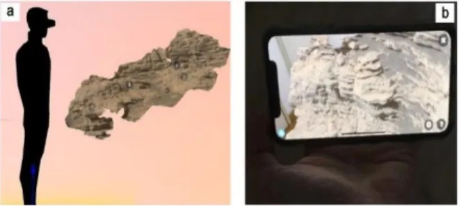
Online Resources: The VR and/or AR rendering of simple orbital and/or ground-based 3D models can be first performed using a web-based solution such as Sketchfab. This offers the possibility to easily visualize, interact, and share medium-resolution 3D models de-rived either from photogrammetric or stereoscopic re-constructions (e.g. https://sketchfab.com/LPG-3D or https://sketchfab.com/planmap.eu, Fig. 1 and 2).
Fig. 1: Use of the Sketchfab online plateform to visualize
dig-ital outcrop models derived from Curiosity imaging data using a Virtual Reality headset (left), or using Augmented Reality with a smartphone (right).
Fig. 2: Example of a structural analysis on sulfate vein net-works in Gale crater described in [6] and viewable directly online on Sketchfab.
Stand-alone applications: We are also investigating how the information from various sources can be inte-grated into a single comprehensive way to display, ma-nipulate, analyze and share both analytical data and re-sults. The use of a more powerful and versatile solution based on a game engine [7] allows the development of such more complex solutions. An application has been developed to recreate common geological measurments tools in VR on the Kimberley area in Gale crater (Mars), allowing the detailed quantitative investigation of a lay-ered outcrop of sedimentary origin (Fig. 3, see also [8]).
Fig. 3: Use of dedicated VR geological measurement tools on
the Kimberley area.
On a second application, we have created an experience integrating visible high-resolution imagery, digital ele-vation and outcrop models, geomorphological maps and compositional maps derived from spectroscopic meas-urements on several test sites such as the Copernicus crater and Apollo 17 landing sites on the Moon, the Crommelin crater, Kimberley area (Gale crater), Jezero
1514.pdf 52nd Lunar and Planetary Science Conference 2021 (LPI Contrib. No. 2548)
crater and Oxia Planum on Mars, and the Hokusai quad-rangle area on Mercury (Fig. 4 and 5). For each of these cases, the use of a VR headset helps to better understand the environment, the scales, and the relationships be-tween different morphological units.
In terms of hardware solutions, when high levels of details and significant data volumes are required, the VR headset has to be coupled to a high-end computer embarking a gaming-rated GPU to process the virtual environment. In the case of more optimized or focused application, a wireless headset such as the Oculus Quest might be powerful-enough to provide a comprehensive experience.
Fig. 4: The integration of orthoimages drapped on a digital el-evation model into a VR environnement allows the user to freely explore and observe the structures from any point of view, without the deformations induced by reprojections on a traditional computer screen.
Conclusion and perspectives: These VR approaches offer new possibilities in terms of data exploration, anal-ysis, and applications for research, education and out-reach simulating “virtual planetary field-trips”. One of
the challenges in the forthcoming years will be to achieve a semi-automated integration and fusion of data sets reprensenting several Terabytes both of orbital and ground based images and digital elevation models, into the constantly evolving VR and AR hardwares. For or-biters and rovers, this integration possibly relies on the use of SPICE kernels to automatically register and inte-grate data taken from orbit and on the ground at scales up to few mm.
Acknowledgments: This project has received funding from the European Union’s Horizon 2020 research and innovation programme under grant agreement No 776276 (PLANMAP). We also thank VR2Planets for the VR tools on Kimberley.
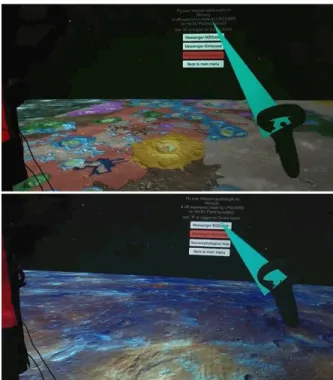
Fig. 5: Integration in VR of Messenger false color mosaics with a geomorphological map on the Hokusai region on Mer-cury.
Bibliography: [1] McGreevy (1993), M.W. Virtual reality and planetary exploration. In Virtual Reality; Elsevier: Am-sterdam, The Netherlands,; pp. 163–197, ISBN 0-12-745045-9. [2] Favalli, M. et al. (2012), Comput. Geosci. 2012, 44, 168–176. [3] Ostwald, A. and Hurtado, J., Proc. of the 48th LPSC, The Woodlands, TX, USA, 2017. LPI Contribution No. 1964, id.1787. [4] Caravaca, G. et al. (2020) Planet Space Sci, 182, 104808, DOI: 10.1016/j.pss.2019.104808. [5] Le Moué-lic, S. et al. (2020) Remote Sensing, 12 (11), DOI: 10.3390/rs12111900. [6] De Toffoli et al. (2020), J. Str. Geol., 137. [7] Nesbit, P.R et al. (2020), GSA Today, vol. 30, 4–10. DOI: 10.1130/GSATG425A.1. [8] Caravaca et al., This issue.
1514.pdf 52nd Lunar and Planetary Science Conference 2021 (LPI Contrib. No. 2548)
![[PDF] Tutoriel Arduino display LCD en pdf | Cours Arduino](data:image/gif;base64,R0lGODlhAQABAIAAAP///wAAACH5BAEAAAAALAAAAAABAAEAAAICRAEAOw==)