HAL Id: hal-02753016
https://hal.inrae.fr/hal-02753016
Submitted on 3 Jun 2020HAL is a multi-disciplinary open access
archive for the deposit and dissemination of sci-entific research documents, whether they are pub-lished or not. The documents may come from teaching and research institutions in France or abroad, or from public or private research centers.
L’archive ouverte pluridisciplinaire HAL, est destinée au dépôt et à la diffusion de documents scientifiques de niveau recherche, publiés ou non, émanant des établissements d’enseignement et de recherche français ou étrangers, des laboratoires publics ou privés.
Distributed hydrological modelling of farmed
catchments (MHYDAS) : assessing the impact of
man-made structures on hydrological processes
Roger Moussa, François Colin, Cécile Dagès, Jean-Christophe Fabre, Philippe
Lagacherie, Xavier Louchart, Michael Rabotin, Damien Raclot, Marc Voltz
To cite this version:
Roger Moussa, François Colin, Cécile Dagès, Jean-Christophe Fabre, Philippe Lagacherie, et al.. Dis-tributed hydrological modelling of farmed catchments (MHYDAS) : assessing the impact of man-made structures on hydrological processes. International Conference on Integrative Landscape Modelling, Feb 2010, Montpellier, France. �hal-02753016�
Distributed hydrological modelling of farmed
catchments (MHYDAS) : assessing the impact
of man-made structures on hydrological
processes
Moussa, R. (1); Colin, F. (2); Dagès, C. (1); Fabre, J.-C. (1); Lagacherie,
P. (1); Louchart, X. (1); Rabotin, M. (1); Raclot, D. (2); Voltz, M. (1)
(1) INRA, UMR LISAH, 2 Place Viala, 34060 Montpellier, France,
[email protected]
(2) SupAgro, UMR LISAH, 2 Place Viala, 34060 Montpellier, France
(3) IRD, UMR LISAH, 2 Place Viala, 34060 Montpellier, France
Abstract: Management of water resources of agricultural catchments has emerged as an environmental priority due to the effects of anthropogenic discontinuities or activities such as the field limits, embankments, drains, ditches, and agricultural practices on runoff, erosion and pollutant transport. MHYDAS, a physically based distributed hydrological model, was especially developed to model water, pollutant and erosion transport, taking into account these discontinuities and practices. A modular approach was undertaken using the platform OpenFLUID, which enables the user to build his own version of MHYDAS by combining various processes (interception, runoff, channel routing, infiltration, transfer in the soil, pollutant fate and transfer, erosion transfer) as a function of the objective of the study and the availability and the accuracy of the data. Application cases are shown and compared in various agro-hydro-climatic conditions in order to study the impact on water and pollutant transfer of tillage practices in the vineyard, stem-flow in tropical volcanic zone and drains in drained catchments. Finally, the model was applied to simulate the impact of various land-use scenarios.
Keywords: Hydrological modelling; Farmed catchments; Land-use scenarios
LANDMOD2010 – Montpellier – February 3-5, 2010 www.symposcience.org
Introduction
Management of land and water resources of agricultural catchments has emerged as an environmental priority due to the effects of land use on runoff, pollutant transport and erosion (De Walle and Pionke, 1994; Gallart et al., 1994; Zhu et al., 1997; Voltz et al., 1998). As compared to natural catchments (e.g. Quinn et al., 1991; Robinson et al., 1995), hydrological processes in agricultural catchments differ since the agricultural land use, the division of the landscape in fields and the ditch network, are significant man-made hydrologic discontinuities in controlling flood generation, pollutant transport and erosion. Man-made structures modify the natural pass of storm water flow across the land surface. Agricultural operations like tillage have an important influence on local surface runoff (De Walle and Pionke, 1994; Pionke and De Walle, 1994) infiltration, and surface storage by altering soil hydrologic properties and soil surface roughness (Mwendera and Feyen, 1993, 1994; Ahuja et al., 1998; Léonard and Andrieux, 1998). Also, the networks of ditches and drains influence the water transfer from the fields to the catchment outlet and the flow exchange between the surface and groundwater since the ditches don’t necessarily follow the steepest slope of the catchment surface topography (Moench et al., 1974; Sharma and Murthy, 1992; Marofi, 1999; Dagès, 2005; Dagès et al., 2008).
To predict the effects of land use change in agricultural catchments, one needs physically-based distributed hydrological models (Bowles and O’Connell, 1991). Although it was once sufficient to model catchment outflow, it is now necessary to estimate distributed surface and groundwater flow characteristics, such as flow depth, flow velocity and water table level. These flow characteristics are the driving mechanisms for sediment and nutrient transport in landscapes and unless they can be predicted reasonably well, water quality models cannot be expected to adequately simulate sediment and nutrient transport. Spatially distributed models using physically realistic, process-based equations are one method of simulating and predicting the hydrologic behaviour of flow processes within catchments (Abbott et al., 1988). In the literature, various models were developed and applied on natural basins (e.g. Abbott et al., 1988; Beven, 1989), however very few take into account the specificities of farmed basins.
MHYDAS (Modélisation HYdrologique Distribuée des AgroSystèmes / Distributed Hydrological Modelling of AgroSystems; Moussa et al., 2002) was especially developed by the LISAH to model hydrological processes taking into account hydrological discontinuities. MHYDAS enables to help the modeller in understanding hydrological processes in farmed systems, and to simulate the impact of various land-use scenarios. A modular approach was undertaken using the platform OpenFLUID (Fabre et al., 2009) which enables the user to build his own version of MHYDAS by combining various processes as a function of the objective of the study and the availability and the accuracy of the data. This paper is structured in three section. First, we present the structure of MHYDAS, then we present the Roujan experimental basin used as a study case in the applications and finally we present application cases in various agro-hydro-climatic conditions.
LANDMOD2010 – Montpellier – February 3-5, 2010 www.symposcience.org
1. Model description
1.1. General structure
MHYDAS is a physically based rainfall-runoff model that was mainly used in farmed contexts (Chahinian, 2004; Tiemeyer, 2007; Charlier, 2007; Ghesquière, 2008). Full details on the model description are available in Moussa et al. (2002).
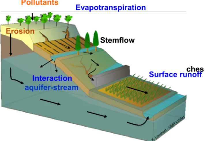
The model consists of a series of interconnected hydrological units, each representing a specific portion of the area of the entire catchment. The interconnection between the hydrological units form a treelike structure which reflects the main drainage pattern and the topography of the basin. Each hydrological unit may be connected to and be receiving channel runoff from upstream units, but it is connected and drains to only one downstream unit (figure 1). Hydrological units differ in the size, topographic features and soil properties of the area units represented by them. Surface runoff is routed on hillslopes and through the channel network taking into account the interaction between the channel network and the aquifer. The program starts with the upstream exterior cells, and proceeds to the downstream cells. A modular approach was undertaken using the platform OpenFLUID (Fabre et al., 2009), which enables the user to build his own version of the model as a function of the objective of the study. The next sections present the procedure developed to subdivide the catchment into hydrological units and the model hydrological components.
Other cultivations Untilled vineyard Tilled vineyard
LANDMOD2010 – Montpellier – February 3-5, 2010 www.symposcience.org
Figure 1. Main processes and hydrological discontinuities represented in MHYDAS.
1.2. Subdivision of the catchment into hydrological units
MHYDAS considers a subdivision of the catchment into irregularly sized and shaped surface and linear topographically-connected hydrological units which allows to take into account a great number of natural and man-made hydrological discontinuities that can be encountered in farmed catchments. Geo-MHYDAS, the GIS tool that help users of MHYDAS - and possible similar models – enables to perform this complex landscape subdivision prior to running the model (Lagacherie et al., 2010). This landscape subdivision has the following characteristics:
- take into account both natural and man-made landscape features of various sizes e.g. subcatchments, soil units, land use units but also ditches network, field boundaries;
- provide both linear and polygonal hydrological units by a specific selective cleaning procedure that performs a user-controlled filtering of the small and/or badly-shaped units; - build a topology that connects all the surface and linear hydrological units along an oriented tree to enable the routing of the simulated flows;
- enable multiple subdivisions for sensitivity analysis of geographical input data through a full automatic subdivision process.
Geo-MHYDAS can be compared to GIS tools that were developed by hydrological model editors to help users in running the models, e.g. geoWEPP (Renschler, 2003) AVSWAT (Di Luzio et al, 2004) or AGWA (Miller et al, 2007). These tools include a landscape subdivision based on DEM-derived subcatchments only. The specificity of Geo-MHYDAS is to implement a more complex subdivision by handling a great variety of landscape features that are not all ordered along the slope. Geo-MHYDAS has been developed under GRASS version 6.3 (GRASS Development Team, 2008) with both Shell and Perl scripts. GRASS was selected because of its large amount of functionalities, both in the raster and in vector mode and because of its ability to be widely distributable as an open source software.
1.3. The model hydrological components
Over each hydrological unit, MHYDAS incorporates the main processes of water, pollutant and erosion transfer (figure 1). The model simulates infiltration-runoff partition as an Hortonian process. The determination of infiltration rate is based on the Morel-Seytoux’s (1982) equations. This model is applied on each hydrological unit to calculate the rainfall excess under variable rain. It depends on the saturated hydraulic conductivity, which is a function of soil surface features. Surface features vary in space and in time as a function of tillage practices. It depends also on the mean initial water content at the soil surface, which is time dependent. It is assumed that its value is measured or calculated independently by a soil water balance calculation. The other parameters are the hydraulic properties of the
LANDMOD2010 – Montpellier – February 3-5, 2010 www.symposcience.org
hydrological units such the saturated hydraulic conductivity, the water content at saturation and the residual water content.
The rainfall excess function for each unit is converted to a surface runoff hydrograph by routing it to the proper outlet of the unit. The operation of converting excess rainfall into surface outflow is carried out by a numerical convolution involving a unit hydrograph derived as a Hayami response function (Moussa, 1996). This procedure is function of the topographic data available from DEMs, such as the mean distance between the centre of gravity of the hydrological unit and the ditch network, the mean slope of the unit, and the Manning roughness.
Once in the network, considered as a set of linear reaches, water is routed to the catchment outlet using the diffusive wave equation (Moussa and Bocquillon, 1996). Over each reach, the parameters of the diffusive wave model are calculated using topographic data such as the length of the reach, its slope, the Manning coefficient of roughness and the cross-sectional shape. The routing function needs also topographical parameters such as the connectivity and the distances between units (surface-surface, surface-linear or linear-linear).
Groundwater is considered as a compartment which get water infiltrated from surface units. Water can also be exchanged between the channel network and the groundwater according to the difference of water levels computed inside these compartments. The used equation has a Darcyan form which needs the saturated hydraulic conductivity of the bottom of each reach of the channel network.
A pollutant transfer module (Louchart, 1999; Louchart et al., 2001) and erosion module (Gumiere, 2009) were also developed. Both pollutant and erosion transfer processes are coupled to surface runoff processes on hillslopes and through the channel network.
2. The study site
2.1. General description
The elementary basin of Roujan is located in the Hérault valley Southern France, about 60 km west of Montpellier (figure 2). It is mainly covered by the vineyards and has a surface area of 91 ha between 75 m and 125 m above sea level. Silty clay loam forms the top soil of the catchment. Four geomorphologic and topographic domains were distinguished within the catchment area : central depression, glacis, terraces and plateau. Soils and geological outcrops differ markedly between these topographical domains. Terraces are usually about 1m high and 10m wide, and have a man made containing wall of limestone (Andrieux et al., 1993). The drainage network is formed by man made ditches and generally follows agricultural field limits.
The climate is Mediterranean with a mean annual precipitation of nearly 700 mm, showing a bimodal distribution with two rainfall peaks one in spring and the other in autumn. The precipitation is usually of high intensity and short duration. The mean annual temperature is about 14°C and mean annual Penman evapotranspiration of 1090 mm.
LANDMOD2010 – Montpellier – February 3-5, 2010 www.symposcience.org
Figure 2. Example of land use and agricultural practices on the Roujan catchment (0.91 km²) in June 1993: non-tilled vineyards (0.53 km²), tilled vineyard (0.18 km²) and other land uses (0.2 km²).
The major runoff events are usually caused by high-intensity, short-duration storms, and the hydrologic response is dominated by Hortonian style runoff with sub-surfaces processes being relatively unimportant. Rainfall intensity and the initial soil moisture state are the main factors affecting runoff production. The proportion of base flow is relatively small in each flood event.
2.2. MHYDAS parameterisation on the Roujan catchment
MHYDAS requires the knowledge of the spatial distribution of parameters of the hydrological units, reaches, and groundwater units. In this application, three kinds of parameters can be distinguished: those extracted from DEMs, those obtained from field observations and those from the analysis of hydrological data at the field scale.
Geometrical characteristics, such as the area, the mean slope and the distance to another unit or to the reach for a given hydrological unit, the length and the mean slope for a given reach, were automatically extracted using Geo-MHYDAS. The following input data were used on the Roujan catchment: A 2x2 m resolution Digital Elevation Model (DEM) derived from low altitude aerial photographs, the delineation of the 237 fields included in the catchment, the delineation of the 11.2 km reach network of the catchment including 257 elementary reaches and a simplified soil map.
Embankments, ditches Interaction aquifer-stream Erosion Stemflow Pollutants Evapotranspiration Surface runoff surface
LANDMOD2010 – Montpellier – February 3-5, 2010 www.symposcience.org
The parameters measured or observed in the field were geometrical characteristics of the ditch network (Lagacherie et al., 2006) such as the reach depth, the reach width, the Manning roughness, together with soil water properties and aquifer geometry. Soil properties, such as the residual water content and the water content at natural saturation were calculated from field observations and considered as mean values over the whole catchment, respectively 0.02 m3/m3 and 0.39 m3/m3. Initial water contents at the soil
surface were estimated separately for each of the four geomorphologic domains: depression, glacis, terraces, and plateau by using field measurements (Hébrard, 2004; Hébrard et al., 2006). The groundwater level at the beginning of the flood event was also obtained from field measurements.
The parameters to be calculated from hydrological data analysis at the field scale are the hydraulic conductivity at natural saturation Ks. As Ks depends essentially on tillage
practices, hydrological units can be grouped for different classes of the hydraulic conductivity. To this aim, we considered three classes of land use corresponding to the three major land uses on the Roujan catchment: non-tilled vineyards, tilled vineyards and other land uses, mainly fallow land and scrubland. Chahinian et al. (2005, 2006a) had used the Morel-Seytoux model coupled to the Hayami unit hydrograph in order to simulate 28 flood hydrographs on a non-tilled experimental field (1200 m²) on the Roujan catchment. The results shows that Ks = 5 mm/h which is quite similar to the infiltrability values
measured on the same field, at a 1 m² scale, by Léonard and Andrieux (1998). A similar approach was also applied by Chahinian et al. (2006b) on a tilled experimental field (3200 m²) on the Roujan catchment. Results shows that the values of Ks decrease from 30 mm/h
just after tillage in spring to 5 to 10 mm/h at the end of summer, and are consistent with the infiltrability values measured by rainfall simulations (Andrieux et al., 2002). For the “other land uses” type, as no observed runoff data at the field scale was available, the value of the hydraulic conductivity Ks was taken equal to 30 mm/h, which is the average of the values
of infiltrability (25 mm/h to 35 mm/h) measured by rainfall simulation on fallow and scrubland. Note that the infiltrability of fallow and scrubland is high all year round because the vegetation is permanent and has a dense root system, which creates large macro-porosity in the surface layers.
3. Applications of MHYDAS
Application cases are shown on farmed catchments in various agro-hydro-climatic conditions : on the Roujan catchment in the vineyard zone southern France (Chahinian, 2004; Ghesquière, 2008), on banana cover in tropical volcanic zone in Guadeloupe (Charlier, 2008), and in artificially drained lowland catchments in temperate zone northern Germany (Tiemeyer, 2007). These applications aim first to study the impact of tillage practices (Chahinian, 2004), stem-flow (Charlier, 2008), drains (Tiemeyer, 2007), erosion (Gumiere, 2009) or to define new indicators of pollution (Wohlfahrt, 2008), and then to apply MHYDAS to quantify the impact of various land-use scenarios.
LANDMOD2010 – Montpellier – February 3-5, 2010 www.symposcience.org
3.1. Impact of tillage practices and ditch network structure
The simulations on the Roujan experimental catchment (Chahinian, 2004; Ghesquière, 2008) showed the sensitivity of MHYDAS and the impact of both tillage practices and ditch network structure on hydrological processes. Soil treatment has an important incidence on simulated runoff volumes at both the field and the catchment scale. Calibration on field runoff data indicated that tillage decreases runoff coefficients and increases infiltration, which agrees with field observations made by Léonard and Andrieux (1998). The most sensitive parameter of MHYDAS is the saturated hydraulic conductivity, which varies in space and in time according to tillage practices. These results point out that it is essential to take into account the influence of soil treatment when simulating hydrological processes at the scale of farmed catchments.
The ditch network constitutes also a man-made linear elements in the landscape, and appears to serve various purposes with regard to water flow. The ditch network accelerates runoff by concentrating flow and avoiding natural obstacles and influence the flow exchange between surface and groundwater. Simulations agree with observations made on natural catchments by Sharma and Murthy (1992); in effect, when the water table is below the ditches’ bed, most of the runoff produced at the field scale infiltrates through the ditch network (Dagès, 2005; Dagès et al., 2008). The exchange coefficients between the ditches and the groundwater depend on infiltration properties of the ditch network, which are generally unknown, and should be measured at different locations of the ditch network. The Manning roughness coefficient can vary in space and time due to the evolution of the vegetation cover in the ditch network.
3.2. Specific case studies
The modular structure of MHYDAS using the platform OpenFLUID enables the modeller to develop his own version of the model as a function of the objective of the study and the available data. Herein some examples of the applications of the model.
MHYDAS was first applied on the Roujan vineyard Mediterranean catchment (Roujan, France) for flood prediction and simulation. The model was applied to simulate surface runoff processes at both the plot (1000 – 3000 m²) and the catchment scales (1 km²). A module to simulate over-bank flow during extreme flood events was developed (Ghesquière, 2008), and more recently a module for erosion transfer (Gumiere, 2009). A framework for sensitivity analysis was proposed by Cheviron et al. (2010), and a spatial parameterisation strategy and multi-criteria approaches were also analysed and compared by Chahinian (2004) and Moussa and Chahinian (2009). Results show that the most sensitive parameters of MHYDAS are the hydraulic conductivity at natural saturation, the Manning roughness coefficient and the coefficients used to simulate the exchange between the channel network and the aquifer.
A second application of MHYDAS was the development of a ‘stem-flow’ module accounting for rainfall partitioning by vegetation in the case of plants concentrating rainwater at the plant foot and promoting stem-flow. The stem-flow function divided the plot into two compartments: one compartment including stem-flow and the related water pathways and one compartment for the rest of the plot. This stem-flow function was
LANDMOD2010 – Montpellier – February 3-5, 2010 www.symposcience.org
coupled with the MHYDAS production function and applied on the Féfé experimental catchment in Guadeloupe (Charlier, 2007; Charlier et al., 2008; 2009). Modelling results showed that the stem-flow function improved the calibration of hydrographs particularly when low flows were observed during residual rainfall.
A third application of MHYDAS was to represent the processes of flow transfer in an artificial drainage system such as tile and ditch drain (Tiemeyer, 2007). It was hypothesised that the tile drain discharge is composed of two components accounting for preferential flow and matrix flow. The fast flow component is modelled by a transfer function approach while the slow drainage discharge is calculated by the Hooghoudt equation. The model was then applied to a small experimental catchment in the lowland area of North-Eastern Germany. Modelled flow volumes, discharge rates and groundwater levels agreed reasonably well with measured (Tiemeyer et al., 2007).
3.3. Impact of land use change
Finally, MHYDAS was used to study the impact of virtual scenarios of land use change. An example is shown for the case of the flood event of 5 June 1997 on the Roujan catchment. Two virtual scenarios named A and B were compared (figure 3) to the observed scenario (figure 2). In both scenarios A and B, we have the same proportion of areas of the three land use classes : tilled vineyard, non-tilled vineyard, other cultivations. Only differs the spatial location of plots within the catchment. In scenario A, the tilled vineyard plots are located in the central depression near the outlet, while the non-tilled vineyard plots are located on the plateau. In the scenario B, we exchange the location of non-tilled and tilled plots.
LANDMOD2010 – Montpellier – February 3-5, 2010 www.symposcience.org
9
Other cultivations
Vineyard with no tillage and total chemical weeding
Vineyard with inter-row tillage and chemical weeding on the rows
Scenario B
Scenario A
Figure 3. Scenarios of land use change : A with the non-tilled plots on the plateau and B with the tilled plots in the depression.
Calculated discharge
0 150 300 05:00 09:00 13:00 5 June 1997 D ischar ge (l/s) Scenario A Scenario BFigure 4. Example of the impact of scenarios of land use change A and B on the simulated hydrograph on the Roujan catchment.
LANDMOD2010 – Montpellier – February 3-5, 2010 www.symposcience.org
The model parameters calibrated for the reference observed hydrograph were applied for both scenarios A and B. Figure 4 shows the impact of spatial land use distribution on the hydrograph shape. We observe that the scenario B reduces the total volume and the peak flow of the hydrograph because the non-tilled fields which produce high runoff coefficients are located far from the outlet, and consequently fluxes re-infiltrates through the channel network.
Conclusions
Hydrological processes on cultivated catchments vary in time and space due to the interaction between agricultural land use (such as fields, terraces, embankments, roads, ditches, etc.) and climatic conditions. These elements constitute hydrological discontinuities that influence runoff contributing areas and pathways for surface runoff. The aim of this paper was to study the role of these hydrological discontinuities. For that, the spatially distributed hydrological model MHYDAS, which is adapted to take into account the specificities of agricultural catchments, was developed and applied to analyse the impact of different land use scenarios.
The modular structure of MHYDAS using the platform OpenFLUID enables the modeller to develop his own version of the model as a function of the objective of the study, the available data and the main hydrological and chemical processes (interception, runoff, channel routing, infiltration, transfer in the soil, pollutant fate and transfer, erosion transfer). Application cases are shown on farmed catchments in various agro-hydro-climatic conditions : on the Roujan catchment in the vineyard zone southern France, on banana cover in tropical volcanic zone in Guadeloupe, and in artificially drained lowland catchments in temperate zone northern Germany. These applications aim first to study the impact of tillage practices, stem-flow, drains, erosion or to define new indicators of pollution. These simulations show that, in farmed catchments, the main hydrological processes during flood events are controlled by man-made hydrological discontinuities, especially tillage practices and ditch network. Tillage is the major factor that influences runoff at the field scale while flow exchange between groundwater and ditches is the major process when routing hydrograph through the ditch network.
Finally, the simulation of various scenarios of land use enable the decision-maker to compare different land use configurations and to propose country-planning schemes. The methodology proposed herein is useful for simulating both sensitivity analysis of distributed hydrological models on farmed catchments, and the long-term geomorphologic evolution of agricultural fields especially after land use changes.
References
Abbott M.B., Bathurst J.C., Cunge J.A., O'Connell P.E., Rassmussen, J., 1988. An introduction to the European Hydrologic System-Système Hydrologique Européen, SHE, Journal of Hydrology, 87, p. 45-59 and 61-77.
Andrieux P., Bouzigues R., Joseph C., Voltz M., Lagacherie P., Bourlet, M., 1993. Le bassin versant de Roujan: caractéristiques générales du milieu. Report of the INRA, Montpellier, 35 pp.
LANDMOD2010 – Montpellier – February 3-5, 2010 www.symposcience.org
Andrieux P., Voltz M., Louchart X., 2002. Temporal evolution of soil infiltration under natural rainfall on tilled and untilled Mediterranean vineyards, COST Symposium, Münchebreg, Germany, 10–12th October 2002.
Ahuja L.R., Fiedler F., Dunn G.H., Benjamin, J.G., Garrison A., 1988. Changes in soil water retention curves due to tillage and natural reconsolidation, Soil Science Society of America Journal, 62, p. 1228-1233.
Beven K.J., 1989. Changing ideas in hydrology - the case of physically-based models, Journal of Hydrology, 105, p. 157-172.
Bowles D.S., O’Connell P.E., 1991. Recent advances in the modeling of hydrologic system, NATO ASI Series C: Mathematical and Physical Sciences, Vol 345, 667 p.
Chahinian N., 2004. Paramétrisation multi-critère et multi-échelle d’un modèle hydrologique spatialisé de crue en milieu agricole, PhD thesis, University of Montpellier II, 238 p.
Chahinian N., Moussa R., Andrieux P., Voltz M., 2005. Comparison of infiltration models to simulate flood events at the field scale, Journal of Hydrology, 306, p. 191-214.
Chahinian N., Voltz M., Moussa R., Trotoux G., 2006a. Assessing the impact of hydraulic properties of a crusted soil on overland flow modelling at the field scale, Hydrological Processes, 20, p.1701-1722.
Chahinian N., Moussa R., Andrieux P., Voltz M., 2006b. Accounting for temporal variation in soil hydrological properties when simulating surface runoff on tilled plots, Journal of Hydrology, 326, p. 135-152.
Charlier J.B., 2007. Fonctionnement et modélisation hydrologique d’un petit bassin versant cultivé en milieu volcanique tropical. PhD thesis, University of Montpellier II, 246 p.
Charlier J.B., Cattan P., Moussa R., Voltz M., 2008. Behaviour of an hydrologic volcanic system located in a small tropical cultivated catchment, Hydrological Processes, 22, p. 4355-4370.
Charlier J.B., Moussa R., Cattan P., Cabidoche Y.M., Voltz M., 2009. Accounting for local rainfall partitioning improve runoff modelling at the plot scale: a study case of rainfall redistribution by plant canopy, Hydrology and Earth System Sciences, 13, p. 2151-2168.
Cheviron B., Gumiere S.J., Le Bissonnais Y., Moussa R., Raclot D. 2010. A framework for sensitivity analysis of distributed physics based erosion models, Water Resources Research, in press. Di Luzio M., Srinivasan R., Arnold J.G., 2004. A GIS-Coupled Hydrological Model System for the Watershed Assessment of Agricultural Nonpoint and Point Sources of Pollution, Transactions in GIS, 8(1), p. 113-136.
Dagès C., 2005. Analyse et modélisation de l'influence de réseaux de fossés sur les échanges surface-souterrain en bassin versant méditerranéen, PhD thesis SupAgro-Montpellier, 243 p.
Dagès C., Voltz M., Ackerer P., 2008. Parameterization and evaluation of a three-dimensional modelling approach to water table recharge from seepage losses in a ditch, Journal of Hydrology, 348, p. 350-362.
De Walle D.R., Pionke H.B., 1994. Streamflow generation on a small agricultural catchment during autumn recharge: II. Stormflow periods, Journal of Hydrology, 163, p. 23-42.
Fabre J.C., Louchart L. et al., 2009. OpenFLUID : Software Environment for Modelling Fluxes in Landscapes (http://www.umr-lisah.fr/openfluid/).
Gallart F., Llorens P., Latron J., 1994. Studying the role of old agricultural terraces on runoff generation in a small Mediterranean mountainous basin, Journal of Hydrology, 159, p. 291-303. Ghesquière J., 2008. Intégration des mécanismes de débordement dans la modélisation hydrologique spatialisée des crues en milieu agricole, PhD thesis, SupAgro-Montpellier, 214 pp.
LANDMOD2010 – Montpellier – February 3-5, 2010 www.symposcience.org
GRASS Development Team, 2008. Geographic Resources Analysis Support System (GRASS) Software, Open Source Geospatial Foundation Project, http://grass.osgeo.org.
Gumiere S., 2009. Contribution à la modélisation déterministe spatialisée de l’érosion hydrique des sols à l’échelle des petits bassins versants cultivés, PhD thesis SupAgro-Montpellier, 263 pp.
Hébrard O., 2004. Stratégie de paramétrisation des humidités de surface sur un bassin versant agricole en milieu méditerranéen, PhD thesis, University of Montpellier II, 230 pp.
Hébrard O., Voltz M., Andrieux P., Moussa R., 2006. Spatio-temporal distribution of soil surface moisture in a heterogeneously farmed Mediterranean catchment, Journal of Hydrology, 329, p. 110-121.
Lagacherie P., Rabotin M., Colin F., Moussa R., Voltz M., 2010. Geo-MHYDAS: A discretization procedure of Cultivated Landscapes for distributed hydrological modelling, Computer and Geosciences, in press.
Lagacherie P., Diot O., Domange N., Gouy V., Floure C., Kao C., Moussa R., Robbez-Masson J.M., Szleper V., 2006. An indicator approach for describing the spatial variability of artificial stream networks in regard with herbicide pollution in cultivated watersheds, Ecological Indicators, 6, p. 265-279.
Léonard J., Andrieux P., 1998. Infiltration characteristics of soils in Mediterranean vineyards in Southern France, Catena, 32, p. 209-223.
Louchart X., 1999. Transfert de pesticides dans les eaux de surface aux échelles de la parcelle et d'un bassin versant viticole : Etude expérimentale et éléments de modélisation. PhD thesis, University of Montpellier II, 243 pp.
Louchart X., Voltz M., Andrieux P., Moussa R., 2001. Herbicides runoff at field and watershed scales in a mediteranean vineyard area, Journal of Environmental Quality, 30(3), p. 982-991.
Marofi S., 1999. Rôle des échanges nappes-fossés dans le fonctionnement hydrologique d’un bassin versant en milieu méditerranéen cultivé. PhD thesis, Ecole Nationale Supérieure Agronomique de Montpellier, 240 pp.
Miller S.N., Semmens D.J., Goodrich D.C., Hernandez M., Miller R.C., Kepner W.G., Guertin, D.P., 2007. The Automated Geospatial Watershed Assessment Tool, Environmental Modeling and Software, 22, p. 365-377.
Moench A.F., Sauer V.B., Jennings M.E., 1974. Modification of routed streamflow by channel loss and base flow, Water Resources Research, 10, p. 963-968.
Morel-Seytoux H.J., 1982. Analytical results for prediction of variable rainfall infiltration, Journal of Hydrology, 59, p. 209–213.
Moussa R., 1996. Analytical Hayami solution for the diffusive wave flood routing problem with lateral inflow, Hydrological Processes, 10, 1209-1227.
Moussa R., Bocquillon C., 1996. Algorithms for solving the diffusive wave flood routing equation, Hydrological Processes, 10, p. 105-124.
Moussa R., Chahinian N., 2009. Comparison of different multi-objective calibration criteria using a conceptual rainfall-runoff model of flood events, Hydrology and Earth System Sciences, 13, p. 519-535.
Moussa R., Voltz M., Andrieux P., 2002. Effects of the spatial organization of agricultural management on the hydrological behaviour of a farmed catchment during flood events, Hydrological Processes, 16, p. 393-412.
Mwendera E.J., Feyen J., 1993. Predicting tillage effects on infiltration, Soil Science, 155, p. 229-235.
Mwendera, E.J., Feyen J., 1994. Effects of tillage and rainfall on soil surface roughness and properties, Soil Technology, 7, p. 99-103.
LANDMOD2010 – Montpellier – February 3-5, 2010 www.symposcience.org
LANDMOD2010 – Montpellier – February 3-5, 2010 www.symposcience.org
14
Pionke H.B., De Walle D.R., 1994. Streamflow generation on a small agricultural catchment during autumn recharge: I. Nonstormflow periods, Journal of Hydrology, 163, p. 1-22.
Quinn P.F., Beven K.J., Chevallier P., Planchon O., 1991. The prediction of hillslope flow paths for distributed hydrological modelling using digital terrain models, Hydrological Processes, 5, p. 59-79. Renschler C., 2003. Designing geo-spatial interfaces to scale process models: the GeoWEPP approach, Hydrological Processes, 17, p. 1005-1017
Robinson J.S., Sivapalan M., Snell J.D., 1995. On the relative roles of hillslope processes, channel routing, and network geomorphology in the hydrologic response of natural catchments, Water Resources Research, 31(12), p. 3089-3101.
Sharma K.D., Murthy J.S.R., 1992. Hydrologic routing of flow in arid ephemeral channels, Journal of Hydrologic Engineering, ASCE 121(6), p. 466-471.
Tiemeyer B., 2007. Quantitative lowland hydrology of artificially drained catchments- Experimental studies and modelling, PhD thesis, University of Rostock, Germany, 223 p.
Tiemeyer B., Moussa R., Lennartz B., Voltz M., 2007. MHYDAS-DRAIN: A spatially distributed model for small, artificially drained lowland catchments, Ecological Modelling, 209, p. 2-20.
Voltz M., Andrieux P., Bouzigues R., Lennartz B., Louchart X., Moussa R., Ribolzi O., 1998. Transport of water and matter in a farmed sedimentary soil system in the mediterranean environment. In Proceedings of the 16th International Congress of Sol Science, Montpellier, 8 p.
Wohlfahrt J., 2008. Développement d’un indicateur de risque d’exposition des eaux de surface aux pertes de pesticides à l’échelle du bassin versant. PhD thesis, Institut National Polytechnique de Lorraine, 164 p.
Zhu T.X., Cai Q.G., Zeng B.Q., 1997. Runoff generation on a semi-arid agricultural catchment: field and experimental studies, Journal of Hydrology, 196, p. 99-118.