HAL Id: hal-02324089
https://hal.archives-ouvertes.fr/hal-02324089
Submitted on 23 Oct 2019
HAL is a multi-disciplinary open access
archive for the deposit and dissemination of
sci-entific research documents, whether they are
pub-lished or not. The documents may come from
teaching and research institutions in France or
abroad, or from public or private research centers.
L’archive ouverte pluridisciplinaire HAL, est
destinée au dépôt et à la diffusion de documents
scientifiques de niveau recherche, publiés ou non,
émanant des établissements d’enseignement et de
recherche français ou étrangers, des laboratoires
publics ou privés.
Active Inversion Tectonics from Algiers to Sicily
Alain Rabaute, Nicolas Chamot-Rooke
To cite this version:
Alain Rabaute, Nicolas Chamot-Rooke. Active Inversion Tectonics from Algiers to Sicily. N.
Sun-dararajan; M. Eshagh; H. Saibi; M. Meghraoui; M. Al-Garni; B. Giroux. On Significant
Applica-tions of Geophysical Methods, Proceedings of the 1st Conference of the Arabian Journal of
Geo-sciences (CAJG-1), Tunisia 2018, VIII, Springer Nature Switzerland, pp.249-252, 2019, Tectonics,
�10.1007/978-3-030-01656-2_56�. �hal-02324089�
Active inversion tectonics from Algiers to Sicily
1Alain Rabaute1,2 and Nicolas Chamot-Rooke3 2
1 Geosubsight, 119 Avenue de Stalingrad, 91120 Palaiseau, France
3
2 Sorbonne Université, CNRS-INSU, Institut des Sciences de la Terre Paris, ISTeP UMR 7193,
4
F-75005 Paris, France. 5
3 Laboratoire de Géologie, Ecole normale supérieure, PSL Research University, CNRS
6
UMR8538, Paris 75005, France 7
8
Abstract. Using an updated active faults map in the easternmost Western Medi-9
terranean (Algeria to Calabria), plus constraints from geodesy (GPS horizontal 10
motion) and seismology (focal mechanisms) input in a strain model, we discuss 11
how the slow Africa-Eurasia motion (4 mm/yr) is accommodated along this 12
segment of the Mediterranean. The width of the inverted domains is variable, 13
strain being concentrated into narrow belts in northern Algeria and north Sicily 14
while it is distributed in Tunisia and over the Pelagian platform. The style of de-15
formation further evolves from west to east, from pure thrusting in Algeria to 16
distributed strike-slip in Tunisia to transtension in the Pelagian grabens. We 17
suggest that the present-day deformation is best explained in terms of (1) ac-18
commodation of the obliquity following a strain partitioning process with dex-19
tral shear onland and en-échelon thrusts offshore northeastern Algeria, along the 20
past trace of the STEP fault that opened the Miocene Algerian Basin, (2) thrust-21
ing offshore northern Sicily along the same STEP fault that opened the Tyrrhe-22
nian Basin in the Pliocene, (3) increasing thin-skin versus thick-skin in Tunisia 23
as a result of inherited structures, (4) far field Ionian slab pull, strongly active at 24
the Mio-Pliocene initiation of the Pelagian grabens and still remnant today. 25
Keywords: Africa/Eurasia Kinematics, Active Tectonics, Strain Partitioning, 26
Inverted Margin, Slab Pull 27
1
Introduction
28
Slow motion between Africa and Eurasia in the easternmost western Mediterranean is 29
accommodated within belts of variable widths, from relatively narrow in central Alge-30
ria (50-100 km), to wide in Tunisia (>100 km). From western Algeria to Sicily the 31
style of active deformation gradually evolves from pure thrust to a combination of 32
strike-slip and thrust (eastern Algeria and Tunisia), and finally to extension in the 33
Siculo-Tunisian Strait. Both width and style of deformation thus evolve from west to 34
east, in relation with the complex geological history of the African margin, a patch-35
work of mountain building (Tell, Atlas), continental block collages (Kabylia), subduc-36
tion, back-arc opening and closing. Based on a recent seismotectonic map of the area 37
2
[1], we discuss the compatibility of the active tectonics with the known present-day 38
regional plate kinematics and the recent geodynamics of the region. 39
2
Active faults and seismicity
40
The core of the work is the identification of active faults, with special attention to 41
offshore areas, in particular Algerian Basin, Tyrrhenian Basin, Pelagian Sea and Ioni-42
an Sea. The mapping process includes the analysis of seismicity, both instrumental 43
and historical, using epicenter locations and focal mechanisms [2]–[4]. Various 44
sources were homogenized to obtain a comprehensive catalogue of earthquakes in the 45
0-50 km depth range. Satellite images on land and seismic profiles offshore further 46
helped in discriminating active faults. The Geographic Information System (GIS) 47
database includes 94 fault segments with parameters and related bibliography. 48
3
Strain modelling using earthquakes and geodetic constraints
49
50
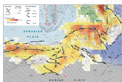
Fig. 1. Strain model based on the style of deformation documented by earthquakes together 51
with GPS constraints. Modelled velocities are shown with respect to Eurasia, together with the 52
effective strain rate (second invariant). Strain-rate axes are shown only in strategic locations. 53
Areas not deforming are colored in green (Tyrrhenian block) and blue (Ionian plain). Structural 54
features are simplified from mapped faults. 55
56
The map is complemented by a strain model based on the style of deformation docu-57
mented by earthquakes together with GPS (Global Positioning System) constraints 58
(Figure 1). Haines & Holt methodology is used to derive a continuous crustal velocity 59
field [5]. The model consists of a finite-element grid, with ~400 grid cells (0.5° by 60
0.5° in dimension) covering the Nubia-Eurasia plate boundary zone between longi-61
tudes 3°E (Algiers) and 18°E (Calabria). To avoid any a priori assumption on the 62
location of the main deformation zones, all cells are allowed to deform, with the ex-63
ception of bottom rows (Nubia) and top rows (Eurasia). 64
The model derives a continuous velocity field by fitting simultaneously observed 65
geodetic velocities and style of deformation (i.e. principal strain axis direction). The 66
continuous velocity gradient tensor field provides estimates of the strain rate tensor 67
(second invariant, dilatational and shear components), rotation rate, interpolated ve-68
locities and rigid plate motions [5]. To put reliable constraints on the far-field velocity 69
boundary condition, the motion of Nubia with respect to Eurasia was prescribed to a 70
global geodetic solution [6]. 71
4
Results
72
Faults map and strain modelling document various patterns of deformation, which are 73
generally attributed to the complex geological history of this segment of the Mediter-74
ranean. The slow convergence (4 mm/yr) is presently accommodated close to the 75
North African margin, at the boundary with the Oligocene to mid-Miocene Algerian 76
Basin and Miocene to Pliocene Tyrrhenian Basin. From Algeria to eastern Sicily, 77
inversion tends to locate close the present-day coastline, which is also the trace of the 78
STEP fault that accompanied the eastward escape of the Ionian slab – resting nowa-79
days below the Tyrrhenian and Calabria – and the successive Algerian and Tyrrhenian 80
openings [7]. In both cases – i.e. northern Algeria and north Sicily – high strain is 81
restricted to a rather narrow belt of thrusts, one of which being responsible for the 82
Boumerdes-Zemmouri earthquake in 2003 [8]. 83
The width of the inverted domain increases eastward with increasing thin-skinned 84
vs thick-skinned deformation [9]. In northeastern Algeria strain is partitioned into 85
strike-slip and reverse faults on land [10], and N80° en-échelon reverse faults offshore 86
[11]. In Tunisia, convergence is accommodated within an area three to four times 87
larger, from the Gafsa fault zone in the south to the northern coast. Obliquity of Afri-88
ca-Eurasia motion is accommodated through a series of E-W trending right-lateral 89
strike-slip faults (Gafsa, Kasserine, Sbiba-Cherichira faults). Conjugate left-lateral 90
strike-slip faults are also active in eastern Tunisia, both onland and offshore (North-91
South axis, Hammamet-Monastir, Sidi Ali Ben Aoun faults). 92
Further east, the Pelagian grabens (Malta, Pantelleria and Linosa) that initiated in 93
the upper Miocene [12] are presently transtensive. Focal mechanisms for the entire 94
Pelagian platform indicate strike-slip [13], while GPS shows that the Pantelleria rift 95
system still accommodates a small extensive component of motion between the Nubia 96
plate and the Apulia-Ionian block [6]. 97
4
5
Conclusions
98
The style of faulting observed from Algeria to Calabria is compatible with Africa-99
Eurasia kinematics but modulated by two effects: structural inheritance of the Atlasic 100
and Alpine phases and a lateral slab pull imposed by the Ionian slab retreat. In north-101
eastern Algeria, the obliquity of convergence is accommodated through a strain parti-102
tioning process, with dextral strike-slip on-land and en-échelon thrusts offshore locat-103
ed at pre-existing sharp boundaries. Strain is accommodated over a larger inverted 104
domain in Tunisia in relation with increased thin-skinned deformation above Triassic 105
salt. Convergence is taken along conjugate strike-slip faults, so that offshore thrusts 106
die out and material is escaping eastward towards the “free” Pelagian side. Pelagian 107
pull was probably stronger in Mio-Pliocene time with the initiation of the Pelagian 108
and Tunisian grabens, retreat of the Ionian slab and last pulse of opening of the Tyr-109
rhenian. Focal mechanisms indicate a progressive stress permutation, from pure 110
thrusting in northern Algeria to strike-slip in Tunisia and finally transtension in the 111
Pelagian grabens, compatible with a moderate but still active pull. 112
References
113
[1] Rabaute, A., Chamot-Rooke, N.: Active Tectonics of the Africa-Eurasia Boundary from 114
Algiers to Calabria, Map at 1:1500000 scale with GIS database, ISBN 978-2-9548197-0-115
9, Geosubsight, Paris (2014). 116
[2] Boschi, E.: A “new generation” earthquake catalogue, Ann. Geofis., 43(4), 1–12 (2000). 117
[3] Guidoboni, E., Ferrari, G., Mariotti, D., Comastri, A., Tarabusi, G., Valensise, G.: 118
CFTI4Med, Catalogue of Strong Earthquakes in Italy (461 B.C.-1997) and Mediterranean 119
Area (760 B.C.-1500) INGV-SGA (2007). 120
[4] Hamdache, M., Pelaez, J. A., Talbi, A., Casado, C. L.: A unified catalog of main earth-121
quakes for northern Algeria from ad 856 to 2008, Seismol. Res. Lett., 81(5), 732–739 122
(2010). 123
[5] Haines, A. J., Holt, W. E.: A procedure for obtaining the complete horizontal motions 124
within zones of distributed deformation from the inversion of strain-rate data, J. Geophys. 125
Res., 98 (B7), 12057–12082 (1993).
126
[6] Pérouse, E., Chamot-Rooke, N., Rabaute, A., Briole, P., Jouanne, F., Georgiev, I., Dimi-127
trov, D.: Bridging onshore and offshore present-day kinematics of central and eastern 128
Mediterranean: Implications for crustal dynamics and mantle flow, Geochem. Geophys. 129
Geosystems, 13(9), 1–25 (2012).
130
[7] Govers, R., Wortel, M. J. R.: Lithosphere tearing at STEP faults: response to edges of 131
subduction zones, Earth Planet. Sci. Lett., 236, 505–523 (2005). 132
[8] Deverchère, J., Yelles, K., Domzig, A., Mercier de Lépinay, B., Bouillin, J.-P., Gaullier, 133
V., Bracène, R., Calais, E., Savoye, B., Kherroubi, A., Le Roy, P., Pauc, H., Dan, G.: Ac-134
tive thrust faulting offshore Boumerdes, Algeria, and its relations to the 2003 Mw 6. 9 135
earthquake, Geophys. Res. Lett., 32(4), 1–5 (2005). 136
[9] Roure, F., Casero, P., Addoum, B.: Alpine inversion of the North African margin and 137
delamination of its continental lithosphere, Tectonics, 31(3), 1–28 (2012). 138
[10] Meghraoui, M., Pondrelli, S.: Active faulting and transpression tectonics along the plate 139
boundary in North Africa, Ann. Geophys., 5, 955–967 (2013). 140
[11] Arab, M., Rabineau, M., Déverchère, J., Bracene, R., Belhaic, D., Roure, F., Marok, A., 141
Bouyahiaoui, B., Granjeon, D., Andriessen, P., Sage, F.: Tectonostratigraphic evolution of 142
the eastern Algerian margin and basin from seismic data and onshore-offshore correlation, 143
Mar. Pet. Geol., 77, 1355–1375 (2016).
144
[12] Argnani, A.: Neogene Basins in the Strait of Sicily (Central Mediterranean): Tectonic 145
settings and geodynamic Implications, in Recent Evolution and Seismicity of the Mediter-146
ranean Region, E. Boschi et al., Springer Netherlands, 173–187 (1993).
147
[13] Soumaya, A., Ben Ayed, N., Delvaux, D., Ghanmi, M.: Spatial variation of present-day 148
stress field and tectonic regime in Tunisia and surroundings from formal inversion of focal 149
mechanisms: Geodynamic implications for central Mediterranean, Tectonics, 34(6), 1154– 150
1180 (2015). 151