HAL Id: tel-01550123
https://tel.archives-ouvertes.fr/tel-01550123
Submitted on 29 Jun 2017HAL is a multi-disciplinary open access archive for the deposit and dissemination of sci-entific research documents, whether they are pub-lished or not. The documents may come from teaching and research institutions in France or abroad, or from public or private research centers.
L’archive ouverte pluridisciplinaire HAL, est destinée au dépôt et à la diffusion de documents scientifiques de niveau recherche, publiés ou non, émanant des établissements d’enseignement et de recherche français ou étrangers, des laboratoires publics ou privés.
suivi d’objets mobiles en environnement routier
Ricardo Omar Chavez Garcia
To cite this version:
Ricardo Omar Chavez Garcia. Fusion multi-capteur pour la détection, classification et suivi d’objets mobiles en environnement routier. Robotique [cs.RO]. Université de Grenoble, 2014. Français. �NNT : 2014GRENM034�. �tel-01550123�
Pour obtenir le grade de
DOCTEUR DE L’UNIVERSITÉ DE GRENOBLE
Spécialité : Mathématique, Informatique (Robotique)Arrêté ministérial :
Présentée par
Ricardo Omar CHAVEZ GARCIA
Thèse dirigée parOlivier AYCARD
préparée au sein Laboratoire d’Informatique de Grenoble
et deMathématiques, Sciences et Technologies de l’Information, Infor-matique
Multiple Sensor Fusion for
Detec-tion, Classification and Tracking of
Moving Objects in Driving
Environ-ments
Thèse soutenue publiquement le25 septembre 2014, devant le jury composé de :
M., Michel DEVY LAAS-CNRS, Rapporteur
M., François CHARPILLET INRIA Nancy, Rapporteur
Mme., Michelle ROMBAUT Gipsa-Lab, Président, Examinatrice M., Yassine RUICHEK
Université de Technologie de Belfort-Montbéliard, Examinateur M., Olivier AYCARD
Classification and Tracking of Moving
Objects in Driving Environments
Advanced driver assistance systems (ADAS) help drivers to perform complex driving tasks and to avoid or mitigate dangerous situations. The vehicle senses the external world using sensors and then builds and updates an internal model of the environment configuration. Vehicle perception consists of establishing the spatial and temporal rela-tionships between the vehicle and the static and moving obstacles in the environment. Vehicle perception is composed of two main tasks: simultaneous localization and map-ping (SLAM) deals with modelling static parts; and detection and tracking moving objects (DATMO) is responsible for modelling moving parts of the environment. The perception output is used to reason and decide which driving actions are the best for specific driving situations. In order to perform a good reasoning and control, the sys-tem has to correctly model the surrounding environment. The accurate detection and classification of moving objects is a critical aspect of a moving object tracking system. Therefore, many sensors are part of a common intelligent vehicle system.
Multiple sensor fusion has been a topic of research since long; the reason is the need to combine information from different views of the environment to obtain a more accurate model. This is achieved by combining redundant and complementary mea-surements of the environment. Fusion can be performed at different levels inside the perception task.
Classification of moving objects is needed to determine the possible behaviour of the objects surrounding the vehicle, and it is usually performed at tracking level. Knowl-edge about the class of moving objects at detection level can help to improve their tracking, reason about their behaviour, and decide what to do according to their na-ture. Most of the current perception solutions consider classification information only as aggregate information for the final perception output. Also, the management of complete information is an important issue in these perception systems. Incomplete in-formation can be originated from sensor-related reasons, such as calibration issues and hardware malfunctions; or from scene perturbations, like occlusions, weather issues and object shifting. It is important to manage these situations by taking into account
The main contributions in this dissertation focus on the DATMO stage of the per-ception problem. Precisely, we believe that including the object’s class as a key element of the object’s representation and managing the uncertainty from multiple sensors de-tections, we can improve the results of the perception task, i.e., a more reliable list of moving objects of interest represented by their dynamic state and appearance informa-tion. Therefore, we address the problems of sensor data association, and sensor fusion for object detection, classification, and tracking at different levels within the DATMO stage. We believe that a richer list of tracked objects can improve future stages of an ADAS and enhance its final results.
Although we focus on a set of three main sensors: radar, lidar, and camera, we pro-pose a modifiable architecture to include other type or number of sensors. First, we define a composite object representation to include class information as a part of the object state from early stages to the final output of the perception task. Second, we propose, implement, and compare two different perception architectures to solve the DATMO problem according to the level where object association, fusion, and classifica-tion informaclassifica-tion is included and performed. Our data fusion approaches are based on the evidential framework, which is used to manage and include the uncertainty from sensor detections and object classifications. Third, we propose an evidential data as-sociation approach to establish a relationship between two sources of evidence from object detections. We apply this approach at tracking level to fuse information from two track representations, and at detection level to find the relations between observa-tions and to fuse their representaobserva-tions. We observe how the class information improves the final result of the DATMO component. Fourth, we integrate the proposed fusion approaches as a part of a real-time vehicle application. This integration has been per-formed in a real vehicle demonstrator from the interactIVe European project.
Finally, we analysed and experimentally evaluated the performance of the pro-posed methods. We compared our evidential fusion approaches against each other and against a state-of-the-art method using real data from different driving scenarios and focusing on the detection, classification and tracking of different moving objects: pedestrian, bike, car and truck. We obtained promising results from our proposed ap-proaches and empirically showed how our composite representation can improve the final result when included at different stages of the perception task.
Key Words: Multiple sensor fusion, intelligent vehicles, perception, DATMO, clas-sification, multiple object detection & tracking, Dempster-Shafer theory
I am highly thankful to my director of thesis and my colleges for all the advices and help.
This work was also supported by the European Commission under interactIVe, a large scale integrating project part of the FP7-ICT for Safety and Energy Efficiency in Mobility. I would like to thank all partners within interactIVe for their cooperation and valuable contribution.
1 Introduction 1
1.1 Perception for intelligent Vehicles . . . 4
1.2 Preprocessing . . . 6
1.2.1 Sensor uncertainty . . . 7
1.3 Simultaneous localization and mapping . . . 8
1.4 Detection, Classification and Tracking of Moving Objects . . . 10
1.4.1 Detection of moving objects . . . 10
1.4.2 Tracking of moving objects . . . 11
1.4.3 Classification . . . 12
1.5 Simultaneous localization, mapping and moving object tracking . . . 13
1.6 Multi-sensor fusion for vehicle perception . . . 13
1.6.1 Requirements of multi-sensor systems . . . 16
1.7 Contributions . . . 16
1.8 Thesis outline . . . 18
2 Intelligent Vehicle Perception 20 2.1 Vehicle perception problem . . . 20
2.2 Simultaneous Localization and Mapping . . . 22
2.2.1 Map representation. . . 24
2.3 Detection and Tracking of Moving Objects. . . 25
2.3.1 Moving Object Detection . . . 26
2.3.2 Tracking of Moving Objects . . . 27
2.3.4 Filtering . . . 30 2.4 Object classification . . . 32 2.4.1 Vehicle classification . . . 34 2.4.2 Pedestrian classification . . . 38 2.5 Multi-sensor fusion . . . 42 2.5.1 Fusion methods . . . 42 2.5.2 Fusion Architectures . . . 53 2.6 Summary . . . 57 3 Methodology overview 59 3.1 interactIVe project . . . 60 3.2 Perception subsystem. . . 63
3.2.1 Perception architecture inside the interactIVe project . . . 64
3.3 Vehicle demonstrator and sensor configuration . . . 64
3.4 Fusion architectures. . . 68
3.5 Sensor data processing . . . 70
3.5.1 Lidar processing . . . 70
3.5.2 Radar targets . . . 77
3.5.3 Camera images . . . 78
3.6 Summary . . . 82
4 Multi-sensor fusion at tracking level 85 4.1 Moving object detection, tracking and classification . . . 87
4.1.1 Lidar sensor . . . 88
4.1.2 Radar sensor . . . 93
4.1.3 Camera Sensor . . . 96
4.2 Multi-sensor fusion at tracking level . . . 99
4.2.1 Instantaneous Combination . . . 100
4.2.2 Dynamic Combination . . . 103
4.4 Summary . . . 107
5 Multi-sensor fusion at detection level 110 5.1 Moving object detection and classification . . . 112
5.1.1 Lidar sensor . . . 113
5.1.2 Radar sensor . . . 114
5.1.3 Camera sensor . . . 115
5.2 Fusion at detection level . . . 116
5.2.1 Data association. . . 117
5.2.2 Moving object tracking. . . 121
5.3 Experimental results . . . 122
5.4 Summary . . . 127
6 Application: Accident Avoidance by Active Intervention for Intelligent Vehi-cles (interactIVe) 129 6.1 Fusion approach integration . . . 130
6.1.1 Modules architecture . . . 130
6.2 Experimental evaluation . . . 139
6.2.1 Real time assessment . . . 140
6.2.2 Qualitative evaluation . . . 140
6.2.3 Quantitative evaluation . . . 142
6.3 Summary . . . 144
7 Conclusion and Perspectives 147 7.1 Conclusions . . . 148
7.2 Perspectives . . . 150
7.2.1 Short-term perspectives . . . 150
7.2.2 Long-term perspectives . . . 151
1.1 Architecture for an autonomous robotic system. . . 5
1.2 Example output of a perception system into a car. Left: image capture of a real urban scenario. Center: Raw measurements from a lidar sen-sor. Right: Environment representation of the real scenario, static and moving objects are highlighted. . . 5
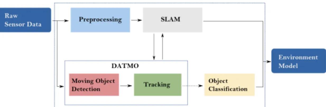
1.3 General architecture of the perception task and its two main compo-nents: simultaneous localization and mapping (SLAM) and detection and tracking of moving objects (DATMO).. . . 6
1.4 Examples of the three main approaches to perform map representation. The representation is based on lidar measurements. . . 9
1.5 Architecture of the proposed approaches for data association and fusion at two different levels: (a) detection level, (b) tracking level. . . 17
2.1 Process diagram for intelligent vehicle perception. . . 21
2.2 Common architecture of a Moving Object Tracking module. . . 28
2.3 Graphical representation of the problem of multiple motion model object tracking (Vu,2009). . . 32
2.4 Results of moving object tracking based on (left) a single motion model and (right) multiple motion models (Wang et al.,2007). . . 32
2.5 Fusion levels within the SLAM and DATMO components interaction. . . 54
3.1 Objectives per vehicle demonstrators involved in the interactIVe project. 61
3.2 Layers inside the system architecture. . . 62
3.3 interactIVe generic architecture. . . 63
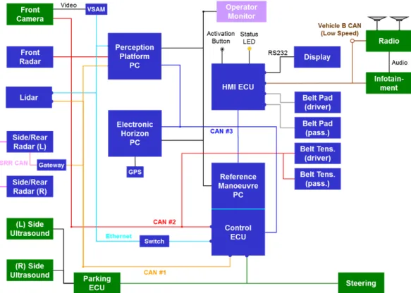
3.5 CRF demonstrator vehicle on Lancia Delta, with location of sensors and driver-interaction channels. Active safety belt is not shown. . . 67
3.6 Architecture of the system modules for the CRF demonstrator vehicle. . 67
3.7 Left: images of the CRF vehicle demonstrator. Right: Field of view of the three frontal sensors used as inputs to gather datasets for our proposed fusion approaches detailed in Chapter 4 and Chapter 5, and for the im-plementation of a real perception application presented in Chapter 6. . . 68
3.8 General overview of our two proposed fusion architectures at tracking (a) and at detection level (b). . . 70
3.9 Sensor model of a laser scanner, the curve models the probability of get-ting at distance d from the lidar position, zmaxrepresents the maximum
range of the scanner (left). Inverse sensor model, this curve models the probability of the presence of an object at different distances for which laser gives the measure zt. (right) . . . 71
3.10 Vehicle motion model P(xt|ut, ˆxt−1) (left). Sampling of vehicle motion
model (right). Vehicle position is considered to be at the center of the vehicle. Blur gray extremes represent the uncertainty in the two compo-nents of control input ut = (νt, ωt). . . 75
3.11 Occupancy grid representation obtained by processing raw lidar data. From left to right: Reference image from camera; static occupancy grid Mt−1 obtained by applying the SLAM solution; current lidar scan
rep-resented in an occupancy grid; detection of the moving objects (green bounding boxes). . . 77
3.12 Informative blocks for each object class detection window, from left to right: pedestrian, car, and truck (for sake of clarity, only some of them are displayed). Histograms of gradients are computed over these sparse blocks and concatenated to form S-HOG descriptors. Average size of the descriptors for pedestrians, cars and trucks are 216, 288 and 288 respec-tively. . . 80
3.13 Examples of successful detection of pedestrians (top) and cars (bottom) from camera images. . . 83
4.1 General architecture of the multi-sensor fusion approach at tracking level. 86
4.2 Architecture of the multi-sensor fusion approach at tracking level for lidar, camera and radar sensors. . . 86
4.3 Fitting model process: fixed object box model (green); L-shape and I-shape segments (red). . . 90
4.4 Output example from pedestrian (top) and vehicle classifiers (down) af-ter being applied over the regions of inaf-terest from lidar moving object detection described in Section 4.1.1. . . 98
4.5 Schematic of the proposed fusion architecture. . . 99
4.6 Results from the proposed fusion approach for moving object classifica-tion in urban scenarios (a,b) . The left side of each image represents the top view representation of the scene (static and moving objects) showed in the right-side image. Bounding shapes and class tags in the right side of each image represent classified moving objects. . . 108
4.7 Results from the proposed fusion approach for moving object classifica-tion in (a,b) highway scenarios. The left side of each image represents the top view representation of the scene (static and moving objects) showed in the right-side image. Bounding shapes and class tags in the right side of each image represent classified moving objects. . . 109
5.1 General architecture of the fusion approach at detection level. . . 111
5.2 General architecture of the fusion approach at detection level for three main sensors: lidar, radar, and camera. . . 111
5.3 Results of the complete DATMO solution for urban areas. Several radar targets are discarded due to lack of support from the other sensor de-tections. The left side of the figure shows the camera image and the identified moving objects. Yellow boxes represent moving objects, green dots represent lidar hits and red circles represent radar detections. The right side of each figure shows the top view of the scene presented in the image. Objects classes are shown by tags close to each object.. . . 123
5.4 Results of the complete DATMO solution for a highway scenario. Ve-hicles at high speeds are detected. The left side of the figure shows the camera image and the identified moving objects. Yellow boxes represent moving objects, green dots represent lidar hits and red circles represent radar detections. The right side of each figure shows the top view of the scene presented in the image. Objects classes are shown by tags close to each object. . . 124
5.5 Results of the complete DATMO solution for urban areas. Several ob-jects of interest are detected. Left side of the figure shows the camera image and the identified moving objects. Yellow boxes represent mov-ing objects, green dots represent lidar hits and red circles represent radar detections. Right side of each figure shows the top view of the scene pre-sented in the image. Objects classes are shown by tags close to each object.125
6.1 Integrated FOP-MOC module architecture. . . 131
6.2 FOP-MOC module output: detection, classification and tracking of cars on test track scenario. The test tracks scenario is part of the CRF facilities. 141
6.3 FOP-MOC module output: detection, classification and tracking of pedes-trians on test track scenario. The test tracks scenario is part of the CRF facilities. . . 141
6.4 FOP-MOC module output: detection, classification and tracking of ob-jects of interest in real scenarios. First case: highway. Second case: urban areas. . . 142
2.1 Feature comparison among the main map representations schemes. . . . 25
3.1 Implemented use cases on the CRF vehicle demonstrator for Continuous Support functions. . . 66
4.1 Number of car/truck miss-classifications from individual lidar and radar tracking modules and from the proposed fusion approach. . . 105
4.2 Number of pedestrian/bikes miss-classifications from individual lidar and radar tracking modules and from the proposed fusion approach.. Highway datasets do not contain any pedestrian or bike. . . 106
5.1 Number of vehicle (car and truck) mis-classifications obtained by the fusion approaches. . . 126
5.2 Number of pedestrian and bike mis-classifications obtained by the fu-sion approaches. Highway datasets do not contain any pedestrian or bike. . . 126
5.3 Number moving objects false detections obtained by the fusion approaches.126
6.1 Quantitative results of the FOP-MOC module for four different scenar-ios: highway, urban area, rural road and test track. Four objects of in-terest are taken into account: (P) pedestrian, (B) bike, (C) car, and (T) truck. . . 145
Introduction
R
OBOTICS is the science of perceiving, modelling, understanding andmanipu-lating the physical world through computer-controlled devices (Thrun,2000). Some examples of robotic systems in use include mobile platforms for plan-etary exploration (Grotzinger et al., 2012), robotic arms used for industrial purposes
(Mason and Salisbury,1985), intelligent vehicles powered by robotics while engaging
in real scenarios (Montemerlo et al.,2006), robotic systems for assisted surgeries (
Ger-hardus,2003) and companion robots assisting humans with many common tasks (
Corade-schi and Saffiotti,2006). Although different, the robotic systems mentioned above have
common applications in the physical world, the ability to perceive their surroundings through sensors, and to manipulate their environment through physical mechanisms.
Intelligent vehicles have moved from being a robotic application of tomorrow to a current area of extensive research and development. Their main objective is to provide safety whilst driving. The most striking characteristic of an intelligent vehicle system (from now on intelligent system), i.e., a system embedded into cars or trucks, is that it has to operate in increasingly unstructured environments, environments that are in-herently uncertain and dynamic.
Safety while driving has been an important issue since the rise of the first auto-motive applications for driving assistance. Systems embedded in intelligent vehicles aim at providing a safe driving experience. These systems are built with the inter-vention of robotics, automotive engineering and sensor design. We can divide them according to the degree of immersion they have. They can focus on environment mon-itoring, to assist the driver with the vehicle navigation and warn him in dangerous scenarios. They can physically intervene to mitigate and avoid collisions or unsafe situations. Ultimately, they can be autonomous and take full control of the vehicle to drive as the user desires. Some of the tasks provided by an intelligent vehicle system
include: automated driving, navigation assistance, moving obstacles detection, traffic signal detection, warning notifications, breaking assistance and automated parking.
The ultimate intelligent vehicle system is one embedded into an autonomous vehi-cle, also known as a driver-less car. We expect to see it soon driving on common city, country or high-speed roads. Some of the tasks we want this vehicle to perform are: transport of people or goods from one point to another without human intervention, sharing the road with other autonomous or human-driven vehicles while following the traffic rules and protecting the safety of the people even in unexpected conditions. Au-tonomous vehicles applications have long been under research since several years ago, in the following we will mention some early milestones achieved in this area.
The Stanford Cart is considered as the first intelligent vehicle, built with some de-gree of autonomy in 1961, its goal was to control a moon rover from Earth using only a video camera (Adams,1961). At that time the vehicle had no on-board computer and was connected to a control console through a long cable and carried a TV camera. By 1971, the vehicle was able to follow a high contrast white line under controlled lighting conditions using video image processing (Schmidt and Rodney, 1971). Another im-provement was made around 1979, when the vehicle used binocular vision to navigate avoiding obstacles in a controlled indoor environment (Moravec, 1980). During the same years, in 1977 Japan’s Tsukuba Mechanical Engineering Lab developed a vehicle capable of driving on a road at a speed of 30 km/h by tracking street markers using only images from a video camera. In 1972, the Artificial Intelligence Center at SRI de-veloped an indoor robotic system equipped with multiple sensors: a TV camera, an optical range finder and tactile sensors.
Limited perception capabilities and underdeveloped processing techniques were a common problem in early intelligent systems. Moreover, they worked only in highly structured indoor environments using specific landmarks or a limited set of obstacle shapes in order to clearly be recognized by the system. However, these works proved that even using limited hardware and software resources, it was still possible to artifi-ciality observe, process and model the world surrounding the system, i.e. to perceive the world, an imperative prerequisite for autonomous navigation.
At the beginning of 1980, using vision techniques along with probabilistic approaches, Dickmanns was able to build cars that could run on empty roads autonomously. His works are regarded as the base of many modern approaches. By 1987, the intelligent vehicle VaMoRs developed by Dickmanns could run at speeds up to 96 km/h and was a strong motivation for the development of the Prometheus project (1987-1995), pro-posed to conduct research for autonomous cars. This project produced two important
events: in 1994, a demonstration of two robot cars (VaMP and VITA-2) driving more than one thousand kilometres on a Paris multi-lane highway in standard heavy traffic at speeds up-to 130 km/h; in 1995, an S-Class Mercedes-Benz car did a round trip from Munich to Copenhagen, driving up-to 175 km/h on the German Autobahn (Dickmanns,
2007). Although the results were impressive and very promising for future research, these cars had many limitations. They could only drive using one lane of the road, this means lane changing and normal high-traffic manoeuvres were not possible. Obstacle detection was limited to vehicles in front of the car and human feedback was a constant input.
Development of new robotic techniques and hardware sensors provided more mo-tivation for the development of intelligent systems for car applications. In 1998, Toyota cars became the first to introduce an Active Cruse Control (ACC) system on a pro-duction vehicle using a laser-based intelligent system. Daimler Chrysler developed a radar-based advance cruise control in 1999 for its high class cars and in 2000 it started to work on vision-based systems for lane departure manoeuvres for heavy trucks.
Later on, a series of DARPA grand challenges, developed by the U.S. government, fostered research and development in the area of autonomous driving. The challenge required an autonomous ground robot to traverse a 200 km course through the Mojave desert in no more than 10 hours. While in 2004, no vehicle travelled more than 5% of the course, five vehicles finished the challenge in 2005. In 2007, the winners were able to complete another challenge by autonomously driving a 96 km long urban track in less than 5 hours. These challenges represent a milestone in the autonomous driving field, however they were able to achieve these goals by using many redundant sensor configurations (Montemerlo et al.,2006).
Recently, there are many research institutes or companies focusing on building autonomous cars. We can mention the driver-less cars from Google Labs1 and from the Free University of Berlin2as modern systems that have set new milestones in au-tonomous vehicle driving. These cars use a sophisticated array of sensors for percep-tion proposes, e.g., 3D lidar scanner, 2D lidar scanners, radar, mono or stereo cameras, among many software resources such that the total cost of sensors and add-ons is su-perior to the cost of the car itself.
Even with their impressive results, the intelligent vehicle systems mentioned above were not capable of dealing with all possible situations that we may encounter while driving in everyday scenarios such as urban areas, rural roads and highways. One of
1http://www.google.com/about/jobs/lifeatgoogle/self-driving-car-test-steve-mahan.html 2http://www.autonomos.inf.fu-berlin.de/
the main reasons is the detailed and precise information required about the environ-ment. This information is delivered by the process of perceiving and processing the data coming from the sensors. One single sensor, due to its limitations and uncertainty, is not capable of providing all necessary information required by intelligent systems. Combining information from several sensors is a current state of the art solution and challenging problem (Vu,2009).
Advance driver assistance systems (ADAS) are a particular kind of intelligent sys-tem. These systems help drivers to perform complex driving tasks to avoid dangerous situations. The main goal of an ADAS is to assist the driver in a safe navigation ex-perience. Assistance tasks include: warning messages when dangerous driving situa-tions are detected (e.g., possible collisions with cars, pedestrians or other obstacles of interest), activation of safety devices to mitigate imminent collisions, autonomous ma-noeuvres to avoid obstacles and attention-less driver warnings. There are three main scenarios of interest for ADAS: highway, countryside and urban areas. Each one of these presents different challenges: high speeds, few landmark indicators, and a clut-tered environment with several types of objects of interest, such as pedestrians, cars, bikes, buses, trucks.
1.1
Perception for intelligent Vehicles
Environment perception is the base of an ADAS. This provides, by processing sensor measurements, information about the environment the vehicle is immersed in. Percep-tion is the first of three main components of an intelligent system and aims at modelling the environment. Reasoning & decision uses the information obtained by perception to decide which actions are more adequate. Finally, the control component executes such actions. In order to obtain good reasoning and control we have to correctly model the surrounding environment. Figure 1.1shows the interaction of the three main compo-nents of a generic intelligent system.
Perception consists of establishing the spatial and temporal relationships among the robot, static and moving objects in the scenario. As Wang summarizes in (Wang et al.,
2007), in order to perceive the environment, first, the vehicle must be able to localize itself in the scenario by establishing its spatial relationships with static objects. Sec-ondly, it has to build a map of the environment by establishing the spatial relationships among static objects. Finally, it has to detect and track the moving objects by establish-ing the spatial and temporal relationships between movestablish-ing objects and the vehicle, and between moving and static objects.
Figure 1.1:Architecture for an autonomous robotic system.
Figure 1.2:Example output of a perception system into a car. Left: image capture of a real urban scenario. Center: Raw measurements from a lidar sensor. Right: Environment representation of the real scenario, static and moving objects are highlighted.
Perceiving the environment involves the selection of different sensors to obtain a detailed description of the environment and an accurate identification of the objects of interest. Due to the uncertain and imprecise nature of the sensors measurements, all the processes involved in the perception task are affected, and have to manage uncertain inputs. Figure 1.2shows an example of an environment representation for a real urban scenario, this figure shows the raw data provided by a lidar sensor and the final rep-resentation of the vehicle’s surroundings obtained using this data. This reprep-resentation should display the static and moving objects in the environment.
Vehicle perception is composed of two main tasks: simultaneous localization and mapping (SLAM) deals with modelling static parts; and detection and tracking of mov-ing objects (DATMO) is responsible for modellmov-ing dynamic parts of the environment. In SLAM, when vehicle location and map are unknown the vehicle generates a map of the environment while simultaneously localizing itself within the map given all the measurements from its sensors. DATMO aims to detect and track the moving objects surrounding the vehicle and predicts their future behaviours. Figure 1.3 shows the
Figure 1.3:General architecture of the perception task and its two main components: simultaneous localization and mapping (SLAM) and detection and track-ing of movtrack-ing objects (DATMO).
main components of the perception task. It takes input sensor measurements and con-trol inputs such as motion measurements, which after the preprocessing or refinement step become the input for SLAM. SLAM and DATMO are considered to be correlated by interactively sharing information (Vu,2009,Wang et al.,2007). The final output is a model of the environment usually composed by the ego-vehicle state, map of static components, and a list of moving objects and their description over time, e.g. position, velocity, type or class.
Management of incomplete information is an important requirement for perception systems. Incomplete information can be originated from sensor-related reasons, such as calibration issues, hardware malfunctions, miss detections, asynchronous scans; or from scene perturbations, like occlusions, weather issues and object shifting. It is im-portant to manage these situations by taking into account the degree of imprecision and uncertainty.
If we are able to obtain reliable results from both SLAM and DATMO in real time, we can use the generated environment model to detect critical situations and warn the driver. Also, we can apply safety protocols automatically, like activating braking systems to avoid collisions, or if it is inevitable, to mitigate damage.
In the next sections we will briefly describe the main components of perception and narrow the domain of our contributions.
1.2
Preprocessing
A sensor is a device that measures and converts a physical magnitude into readable data that can be processed by a computer. Sensors are the input mechanisms of
per-ception systems and the only way to obtain direct information from the environment. Their counterparts are the actuators, which are the output mechanisms that interact with the environment. Usually, a sensor measures a single aspect of the environment; hence, to get information about all the needed aspects of the environment, different sensors are commonly used. This allows the ability to obtain a more accurate and com-plete environment representation. According to their interaction with the environment, sensors can be classified into two categories: passive and active. On one hand, passive sensors only measure the energy emitted by entities in the environment. On the other hand, active sensors emit energy into the environment and then observe the change this energy causes in the state of the environment.
When camera sensors are used to detect moving objects, appearance-based ap-proaches are preferred and moving objects can be detected despite if they are moving or temporally static. If lidar sensors are used, feature approaches are usually preferred and relies on the moving behaviour of the obstacles through time (Wang and Thorpe,
2002).
The decision of which and how many sensors to use highly depends on the re-quirements of the application. For example, when high precision of the position of the objects of interest is needed, a 2D laser scanner is the most common choice, while when object recognition is required camera sensors could be better suited for the task. 3D laser scanners are becoming the most popular option nowadays due to their high precision and ability to extract accurate volumetric information of the objects from the scene. However, processing 3D data requires high computational resources. Besides, 3D laser scanners are not affordable for commercial applications.
1.2.1 Sensor uncertainty
In order to correctly model the behavior of sensors we have to be aware of their un-certain nature. Sensor unun-certainty might come from hardware limitations which allow only to give an estimation of a real physical quantity. Environment noise or technical limitations and failures of the sensors can generate random errors in the sensor mea-surements, and represent another source of uncertainty. Uncertainty can come in a systemic way from calibration issues and from transformation errors from the sensor space to a common representation (Hall and Llinas,1997,Mitchel,2007).
Uncertainty management is an integral part within the perception task, it includes the association of uncertain and imprecise data with partially complete information, and the updating process of confidence factors. A sensor measurement is an approximation
of a real physical quantity. The confidence of a measurement represents a judgment about the validity of the information provided by this measurement. Its imprecision concerns the content of this information and is relative to the value of the measurement while the uncertainty is relative to confidence of the measurement (Dubois and Prade,
1985).
Sensor modeling is the description of the probabilistic relation between the sensor measurement and the actual state of the environment and is used to model its behav-ior (Elfes,1989). Contrary to this concept exists the inverse sensor model which gives the probability of a certain environment configuration given a sensor measurement.
1.3
Simultaneous localization and mapping
Simultaneous localization and mapping (SLAM) allows robots to operate in an un-known environment and then incrementally build a map of the environment using information provided by their sensors; concurrently robots use this map to localize themselves. This map is supposed to be composed only of static elements of the envi-ronment. Moving objects have to be detected and filtered out using this so called static map.
In order to detect and track moving objects surrounding a moving vehicle, precise localization information is required. It is well known that position-based sensors like GPS or DGPS often fail in cluttered areas. Works like the one proposed byWang et al.
(2007), state that this issue is due to the canyon effect, and suggest (showing improve-ments regarding both tasks) a simultaneous relation between SLAM and DATMO.
Prior to detecting moving and static obstacles surrounding the vehicle, we must obtain a map representation of the environment. Three approaches are broadly used by current state of the art mapping applications:
• Direct approach uses raw data measurements to represent the physical envi-ronment without extracting predefined features, e.g. point clouds representa-tions (Lu and Milios,1997).
• Feature-based approach compresses measurement data into predefined features, for example geometric primitives like points, lines, circles (Leonard and
Durrant-Whyte,1991).
• Grid-based approach subdivides the environment into a regular grid of cells, and then a probabilistic or evidential measure of occupancy is estimated for each cell
Figure 1.4:Examples of the three main approaches to perform map representation. The representation is based on lidar measurements.
(Elfes,1989,Moras et al.,2011b).
Despite the advantages of representing any kind of environment, direct approaches are infeasible regarding memory use and are unable to represent the sensors’ uncer-tainty. Feature-based approaches are compact, but cannot properly represent complex environments using simple primitives. The grid-based approach is more suitable for our task because they are able to represent arbitrary features, provide detailed rep-resentations, and take into account sensor characteristics by defining sensor models. Figure 1.4 shows an example of the map representations obtained by the three main approaches mentioned above.
The occupancy grid approach has become the most common choice among map representation methods for outdoor environments due to its advantages over the oth-ers. Its main drawback is the amount of memory needed to represent a large outdoor environment; however, works like the ones presented by Wang and Thorpe(2002)
and Vu(2009) have proposed to overcome this issue, their idea is that since the sen-sor’s range is limited, there is only a need to construct a local grid map limited by the non-measurable regions. Afterwards local maps are assembled to build a global map.
Vu (2009) proposes an interesting solution to solve the SLAM problem which is based on an occupancy grid to represent the vehicle map, and free-form objects to rep-resent moving entities. To correct vehicle location from odometry he introduces a new fast incremental scan matching method that works reliably in dynamic outdoor envi-ronments. After a good vehicle location is estimated, the surrounding map is updated incrementally. The results of his method in real scenarios are promising. Therefore, we decided to use his method as a basis for our perception solution. However, our solution is not focused on the SLAM component but in the DATMO component of the perception problem.
1.4
Detection, Classification and Tracking of Moving Objects
Moving object detection aims at localizing the dynamic objects through different data frames obtained by the sensors in order to estimate their future state. The object’s state has to be updated at each time instance. Moving object localization is not a simple task even with precise localization information. The main problem occurs when in cluttered or urban scenarios because of the wide variety of objects of interest surrounding the vehicle (Baig,2012,Vu,2009,Wang et al.,2007). Two main approaches are used to detect moving objects. Appearance-based approaches are used by camera-based systems and can detect moving objects or temporally stationary objects. Featured-based approaches are used when lidar (laser scanners) sensors are present and rely on the detection of the moving object by their dynamic features. Both approaches rely on prior knowledge of the targets.
Although they become more necessary when in crowded areas, we can define three tasks independent of the scenario to attempt to solve the DATMO problem: detec-tion of moving objects, moving object tracking (involving data associadetec-tion and modetec-tion modelling), and classification.
1.4.1 Detection of moving objects
Detection of moving objects focuses on discriminating moving parts from the static parts of the map. Due to the wide variety and number of targets that can appear in the environment and to their discriminative features, it is infeasible to rely on just one
environment representation to differentiate the moving objects from the static ones: e.g., feature or appearance-based representation. Whilst detecting moving objects, the system has to be aware of noisy measurements that lead to possible false detections of moving objects and mis-detections originated by the same noisy measurements or due to occlusions.
1.4.2 Tracking of moving objects
Once we detect the moving objects, it is necessary to track and predict their behaviour. This information is used afterwards in the decision-making step. Tracking of mov-ing objects is the process of establishmov-ing the spatial and temporal relationship among moving objects, static obstacles and the ego-vehicle. The tracking process uses the motion model of the objects to properly estimate and correct their movement and posi-tion (Thrun et al.,2005). The need of object tracking originates, in part, from the prob-lems of moving object detection, for example, temporary occlusions or mis-detections of an object can be managed by the estimation of its position based on the object’s mo-tion model and momo-tion history. Contrary to the SLAM problem, the DATMO problem does not have information about the moving objects’ motion models and their odom-etry. Usually, this information is partially known and is updated over time; therefore, the motion models of moving objects have to be discovered on-line and the ADAS system has to be aware of the probable change in their dynamic behaviour. Ground moving object tracking presents a challenge due to the changes of motion behaviour of objects of interest. For example, a car can be parked or waiting at a traffic light and after moving at a constant acceleration (Chong et al.,2000).
The basic scenario for a tracking task appears when just one object is being detected and tracked. Hence, in this basic scenario we can assume that each new object detec-tion is associated with the single track we are following. However, this situadetec-tion is far from the real scenarios where intelligent vehicles are deployed. When there are sev-eral moving objects, the tracking process becomes more complex and two main tasks emerge: data association and track management. The data association task is in charge of associating new object detections to existing object tracks whenever possible, whilst tracking management is in charge of maintaining the list of tracks up-to-date by apply-ing operations over the tracks such as: creatapply-ing tracks for new objects, deletapply-ing tracks of unobserved objects, and merging or splitting tracks.
1.4.3 Classification
Knowing the class of objects surrounding the ego-vehicle provides a better understand-ing of drivunderstand-ing situations. Classification is in charge of taggunderstand-ing an object accordunderstand-ing to its type, e.g. car, pedestrian, truck, etc. We consider the class of the objects as an im-portant addition to the perception process output but as well as key information to improve the whole DATMO component. Motion modelling provides preliminary in-formation about the class of moving objects. However, by using appearance-based information we can complement knowledge about the class of objects the intelligent vehicle is dealing with despite the temporal static nature of the objects or partial mis-detections. Although it is seen as a separate task within the DATMO task, classification can help to enrich the detection stage by including information from different sensor views of the environment, e.g. impact points provided by lidar, image patches pro-vided by camera. Evidence about the class of objects can provide hints to discriminate, confirm, or question data association decisions. Moreover, knowing the class of a mov-ing object benefits the motion model learnmov-ing and trackmov-ing which reduces the possible motion models to a class-related set.
An intelligent vehicle can be positioned in several kinds of scenarios. These scenar-ios can contain many kinds of moving objects of interest, such as pedestrians, bicycles, motorcycles, cars, buses and trucks. All these objects can have different appearances, e.g. geometry, textures, intra-class features; and different dynamic behaviour, e.g. ve-locity, acceleration, angular variation. When using laser scanners, the features of mov-ing objects can change significantly from scan to scan. When usmov-ing camera sensors, the quality of visual features can be drastically decreased due to occlusions or weather conditions. As a result, it is very difficult to define features or appearances for detect-ing specific objects usdetect-ing laser scanners. Moreover, a sdetect-ingle sensor is not enough to cover all the objects of interest in a common driving situation. For several decades, the need for assembling arrays of sensors for intelligent vehicle perception has been a requirement to provide robustness for ADAS.
Most of the current DATMO solutions consider classification information only as an aggregate information for the final perception output. Few considerations have been made to include object class information as complementary data for object detection, and use it as a discrimination factor for data association and as feedback information for moving object tracking. We believe that classification information about objects of interest gathered from different sensors can improve their detection and tracking, by reducing false positive detections and mis-classifications. Moreover, a fusion solution for multiple sensor inputs can improve the final object state description.
1.5
Simultaneous localization, mapping and moving object
track-ing
Both SLAM and DATMO have been studied in isolation (Bar-Shalom and Li, 1998,
Blackman, 2004,Civera et al.,2008). However, when driving in highly dynamic
envi-ronments, such as crowded urban environments composed of stationary and moving objects, neither of them is sufficient. Works like the ones reported byWang et al.(2007) and Vu(2009) proposed a solution to the problem of simultaneous localization, map-ping and moving object tracking which aims at solving the SLAM and the DATMO problems at once. Because SLAM provides more accurate pose estimates and a sur-rounding map, a wide variety of moving objects are detected using the sursur-rounding map without using any predefined features or appearances, and tracking is performed reliably with accurate vehicle pose estimates. SLAM can be more accurate because moving objects are filtered out of the SLAM process thanks to the moving object loca-tion predicloca-tion from DATMO. SLAM and DATMO are mutually beneficial.
Vu (2009) proposes a perception solution based on the simultaneous relation be-tween SLAM and DATMO. Although he considers classification information, he uses it as an aggregation to the final output and not as interactive factor to improve the per-ception result. Moreover he uses the class information in a deterministic way which disables the uncertain management and indirectly limits the real-time capabilities of his solution. Although focusing on the DATMO component, our perception solution includes the class information as a distribution of evidence considering uncertainty from the sources of information and transferring this evidence until the final result.
1.6
Multi-sensor fusion for vehicle perception
Although combining information from different senses is a quite natural and effort-less process for human beings, to imitate the same process in robotics systems is an extremely challenging task. Fortunately this task is becoming viable due to the avail-ability of new sensors, advanced processing techniques and algorithms, and improved computer hardware. Recent advances in computing and sensing have provided the capability to emulate and improve the natural perceiving skills and data fusion capa-bilities.
Information fusion consists of combining information inputs from different sources in order to get a more precise (combined) output which is generally used for decision-making tasks. This process includes three main subtasks: data association, which finds
the data correspondence between the different information sources; estimation, com-bines the associated data into an instantaneous value; and updating, which incorpo-rates data from new instances into the already combined information. Improvements in fusion approaches can be made by focusing on the data representation for individ-ual and combined values, the design architecture of the fusion approach, and in the management of uncertain and imprecise data.
Sensors are designed to provide specific data extracted from the environment. For example, lidar provides features like position and shape (lines) of obstacles within its field of view, camera sensors provide visual features that can be used to infer ap-pearance information from obstacles, like class of the objects. Intelligently combin-ing these features from sensors may give a complete view of the objects and the envi-ronment around the intelligent vehicle and it is the objective of a fusion architecture. Multi-sensor fusion has become a necessary approach to overcome the disadvantages of single-sensor perception architecture and to improve the static and dynamic object identification providing a richer description. Improvements in sensor, processor and actuator technologies combined with the trending initiative of the automotive industry and research works have allowed the construction and application of several intelligent systems embedded in modern consumer vehicles.
Real driving scenarios represent different challenges for the perception task: high speeds, few landmark indicators, and a cluttered environment with different types of objects of interest. Several research works have proposed that using information from several sensors may overcome these challenges by obtaining redundant or comple-mentary data. For example, camera sensors can be used to capture the appearance of certain objects or landmarks using features like colors, textures or shapes. Camera data is sensible to frequent changes in the ambiance. Other sensors, like lidar, can provide complementary or redundant information to deliver a set of discrete points of impact on static and moving objects. It is clear that there is no universal sensor hardware capable of sensing all the measurements that an intelligent vehicle needs to precisely perceive every environment. For this reason, we decide to include many sensors as the interface with the environment to complement or verify the information provided by them. However optimally fusing information from these sensors is still a challenge.
Fusion methods applied to the vehicle perception can help to: enrich the represen-tation of the surrounding environment using complementary information; improve the precision of the measurements using redundant information from different sensors or other dynamic evidence sources; and manage uncertainty during the fusion process by identifying and associating imprecise and uncertain data which would help to update
the confidence levels of fused information. Fusion approaches have to take into ac-count the nature of the data provided for each sensor, sensors’ field of view, degree of redundancy or complementation of provided data, synchronization of the inputs, and the frequency of the fusion mechanism.
Although information fusion from different sensors is a challenging task for au-tonomous and even semi-auau-tonomous vehicles, due to new sensor technologies and improvements in data processing algorithms this task is becoming more feasible. Mod-ern computer techniques and hardware have helped current intelligent vehicles sys-tems to fuse information from a wide range of sensor types, e.g. passive sensors like single and stereo cameras, or active sensors like radar or lidar.
Several methods have been proposed to combine information from different sen-sor observations, these can generally be classified by the approach they are based on: Bayesian, Evidential and fuzzy. Most of them are thought to work with raw data, but when data at detection level is available similar approaches can be used (Castellanos
et al., 2001). Methods that use raw information as inputs (e.g. lidar scans) have to
perform the very first stages of the perception process: map building, localization and moving object detection. Sometimes modern sensors just provide information at de-tection level, i.e. a list of detected objects, in this case the fusion process is expected to provide a unique list of objects to improve the individual ones. Our work focuses on fusing objects’ state information at two levels within the DATMO problem. The fusion approaches take into account all the available information from observed and known objects, such as kinetic information (position, velocity) and class information. The purpose of these approaches is to observe the degree of improvement achieved by the inclusion of class information at the detection level and at the tracking level.
Although there are several approaches in the current literature trying to improve the perception output by fusing information from different sensors, few of them con-sider the uncertainty and imprecision from sensors and integrate them into the detec-tion and tracking stages of DATMO task. The transferred belief model (TBM) repre-sents, in a quantified way, beliefs obtained from belief functions. This model is able to explicitly represent uncertainty and inaccuracy of an event. Also, it manages quantita-tive and qualitaquantita-tive data and models the unknown evidence as well as the known evi-dence. Within the intelligent vehicle perception, TBM has been considered as the main technique for sensor fusion, scene interpretation, object detection, object verification, data association and tracking. This model proposes an alternative to Bayesian theory and overcomes some of its limitations by being able to manage uncertainty, transfer belief measures, propose inference mechanisms and to be clearly analogous to human
reasoning process. Our proposed work relies on TBM to represent object class hypothe-ses, perform evidence fusion information and to deal with data association problem at different levels in the perception process.
1.6.1 Requirements of multi-sensor systems
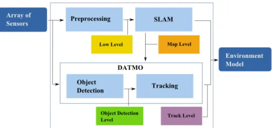
In previous sections we have introduced the problem of single-sensor perception sys-tems and the idea of how multiple sensors can be included inside the perception task. In order to develop a multi-sensor system, we have to propose and implement sev-eral modules. First, sensor data processing takes the raw data from sensors and using sensor-based models, transforms this raw data into useful information. Raw data pro-cessing modules depend on the number and type of sensors installed on the demon-strator. Second, SLAM modules take the processed data to create a map and perform localization. These modules might need to implement data fusion at this stage. Third, preprocessed data and the output from the SLAM component are taken by the DATMO modules to identify, classify and track moving objects. Fusion at this level combines lists of tracks, and in case no data fusion was performed in SLAM component, it must implement fusion of detected objects.
In this dissertation, we propose two multi-sensor fusion approaches at DATMO level. Therefore, we follow the data flow described above. In Chapter2, after the state-of-the-art description, we introduce the data processing modules for lidar, radar and camera which are common to both proposed fusion approaches. Besides, in Chap-ters4and5we describe in detail our different proposed modules inside the two fusion approaches and how the data processing modules take place to construct a whole per-ception solution.
1.7
Contributions
The approach proposed in this dissertation focuses on the DATMO stage of the per-ception problem. Regarding the state of the art approaches, we assume the SLAM stage as a solved task, and focus on the detection, tracking and classification of moving objects. Precisely, we believe that including objects class as a key information along managing the uncertainty from sensor data processing we can improve the results of the perception task, i.e. a more reliable list of moving objects of interest represented by their dynamic state and appearance information. Therefore, we address the problems of sensor data association, sensor fusion for object detection and tracking at different
levels within the DATMO stage. We assume that a richer list of tracked objects can improve future stages of an ADAS and enhance its final application.
(a)
(b)
Figure 1.5:Architecture of the proposed approaches for data association and fusion at two different levels: (a) detection level, (b) tracking level.
Before focusing on our proposed approaches we reviewed the state-of-the-art works regarding the perception task for intelligent vehicle systems, focusing on the auto-motive applications for outdoor environments. This review considers not only the DATMO but the SLAM task to be aware of the closer relation and interaction between them. We follow works regarding sensor data processing, environment representation, moving object dynamics modelling, data association, filtering and fusion techniques. Although we focus on a set of three main sensors: radar, lidar and camera, we propose a modifiable architecture to include other types or number of sensors. A detailed de-scription of the set of sensors and the vehicle architecture is given in Section 3.5. Even though we are describing our contributions in detail later in this dissertation, we can briefly mention them as follows.
First, we define an object representation to include class information as a part of the object state from early stages to the final output of the perception task and not only as an aggregate output value.
Second, we propose, implement and compare two different perception architec-tures to solve DATMO problem according to the level where object association, fusion and classification information is included and performed. Our data fusion approaches are based on the evidential framework and are composed of instantaneous fusion of current measurements and dynamic fusion of previous object states and current evi-dence. Figure 1.5shows the architecture of the two proposed approaches.
Third, we propose an evidential data association approach to establish a relation-ship between two sources of evidence from object detections. We apply this approach at the detection level to fuse information from two sensor detections and at tracking level to find the relations between observations and tracks of known objects. We ob-serve how the class information improves the final result of the DATMO component.
Fourth, we integrate the proposed fusion approaches as a part of a real-time vehicle application. This integration has been performed in the framework of the interactIVe European project. This project pursues the development of an innovative model and platform for enhancing the perception of the traffic situation in the vicinity of the ve-hicle. Precisely, our work takes place in the perception stage and integrates different information sources like raw sensor data, state of the vehicle, and road edge detections as inputs to perform the perception task. Moreover, our implementation provides a list of tracks of moving objects of interest and identifies the static obstacles in the environ-ment. Given the presence of different sources of evidence and uncertainty, we tested our two fusion strategies to include classification information as a key parameter to improve the perception output.
Fifth, we analyse and experimentally evaluate the performance of the proposed methods based on the detection, tracking and classification of multiple objects in dif-ferent driving scenarios. We compare our evidential approaches against each other and against a state-of-the-art work proposed byVu (2009) using real data from a ve-hicle demonstrator of the interactIVe project. This comparison focuses on the detection and classification of moving objects.
1.8
Thesis outline
The organization of the rest of this dissertation is as follows. In Chapter2, we review the state-of-the-art works that solve the perception problem. We start by formally in-troducing the two main components of the intelligent vehicle perception: SLAM and DATMO. Then, we focus on the DATMO component analysing the different work pro-posals for each of its internal subtasks. After analysing the single sensor problem, we review the different methodologies and architectures for multi-sensor solutions that are related to our contributions.
Chapter 3 presents the sensor configuration we use in this dissertation and the sensor processing methods implemented to gather, process, and represent the environ-ment. The methods presented in this chapter are common to our two multi-sensor con-tributions. Also, this chapter presents an overview of the interactIVe European project
highlighting the goals and requirements of the perception system inside. This overview helps us to visualize the structure of the real perception system we will detail in Chap-ter6. In order to give a general perspective of our two fusion architectures, in Chap-ter3, we also introduce an overview of the general architectures that will be detailed in Chapters4and 5.
In Chapter4, we describe the first complete DATMO solution using our fusion ap-proach at tracking level. Here, we follow the common late fusion architecture adding class information to the object representation and using it to improve the final moving object classification. Two main trackers are implemented using lidar and radar data. Preliminary class information is extracted from the three sensors after moving object tracking is performed. Experimental results are presented to verify the improvement of the fusion approach with respect to the single-sensor trackers.
In Chapter5, we describe a second complete DATMO solution using our fusion ap-proach at detection level. Here, we proposed several classification methods based on the early object detections from the three sensors. We propose and build a composite object representation at detection level based on the kinematic and class information of the detected objects. We also propose a data association method to find relations be-tween different lists of moving object detections. Besides, an enhanced version of the moving object tracking presented in Chapter4is described using the aforementioned composite representation. We conduct several experiments to compare the two pro-posed fusion approaches and analyse the improvement of an early consideration of the class information inside the DATMO component.
The description of a real intelligent vehicle application using our composite ob-ject description proposal and a combination of the methodologies inside our fusion approaches is detailed in Chapter 6. This application is built inside the interactIVe Eu-ropean project and tested in on-line and off-line demonstrations. In the same chapter, an experimental set-up, several tests in real driving scenarios and an evaluation section are included to verify the performance of our contributions inside the whole intelligent vehicle solution. Finally, we summarize our conclusions and present some perspectives of future works in Chapter7.
Intelligent Vehicle Perception
P
ERCEPTIONconsists of establishing the spatial and temporal relations betweenthe vehicle and its surrounding environment. In this chapter, we review the state-of-the-art of the main components of vehicle perception problem: SLAM and DATMO. First, we formally present the problem of perception for intelligent vehi-cle systems. Second, we define the component of SLAM and focus on DATMO com-ponent where our contributions are present. Third, we analyse separately the modules inside DATMO to present the main related works. Fourth, we present the problem of multi-sensor fusion and offer a review of the state-of-the-art according to the most used fusion techniques and to the different fusion architectures. Finally, we summa-rize the analysis of the state-of-the-art and highlight the fusion methods and fusion architectures present in our contributions.
2.1
Vehicle perception problem
In Chapter 1, we presented the problem of perception for intelligent vehicles as the process of generating a representation of the environment surrounding the vehicle by interpreting the data from vehicle sensors. This process involves the estimation of ve-hicle position in the environment, the relative positions of static and moving objects around the vehicle, and the tracking of objects of interest. We can see a graphical rep-resentation of the perception problem in Figure2.1. In order to discuss state-of-the-art approaches that have been developed to solve the perception problem, we need to for-mally define this problem. Given a set of sensor observations Ztdefined as:
Zt = {z0, z1, ..., zt}, (2.1.1)
and control inputs Utup to time t defined as:
the perception process is divided in two main components: simultaneous localization and mapping (SLAM) which captures the static part of the environment; and detection and tracking of moving objects (DATMO) which determines and follows the moving entities over time. These components are defined in detail in Sections 2.2 and 2.3
respectively.
Figure 2.1:Process diagram for intelligent vehicle perception.
Vehicle perception provides, up to time t, three main outputs: first, the set of esti-mated vehicle states:
Xt = {x0, x1, ..., xt}, (2.1.3)
usually defined by its position and orientation; second, the set of i static objects in the environment, also known as the map:
Mt= {m0, m1, ..., mK}, (2.1.4)
where K is the total number of objects in the environment, and each mk, with 1≤k≤K, specifies properties and location of each object; finally, the set of J moving object tracks at time t, for 1≤ j≤ J is defined as:
Tt= {o1, o2, ..., oJ}. (2.1.5)
Current literature show that we can define the perception problem as an a posteriori probability calculation:
P(xt, Mt, Tt|Zt, Ut, x0), (2.1.6)
where x0represents the initial state of the vehicle. Moreover, as was mentioned above, we can divide the perception into SLAM:
P(xt, Mt|Zst, Ut, x0), (2.1.7)
and DATMO:
where Ztis decomposed into static Ztsand dynamic observations Ztd:
Zt =Zts+Zdt. (2.1.9)
Usually, state-of-the-art approaches consider SLAM and DATMO as separate prob-lems. However, recent research works have proposed several methods that perform SLAM and DATMO simultaneously. This general problem is known as Simultaneous Localization, Mapping and Moving Object Tracking (SLAMMOT). Several works, such as the ones presented byHähnel et al. (2003) and Montesano et al. (2005), have pro-posed simplified SLAMMOT solutions for indoor environments. Fortunately, recently works like (Wang et al.,2007) and (Vu,2009) have developed real-time applications for outdoor environments which represent the milestone we follow in this dissertation.
In the following sections we describe in detail SLAM and DATMO components; and their interaction as a correlated problem. We present the single sensor solution to solve the perception problem and afterwards we introduce the fusion solutions where our proposed approaches take place. Besides, we present the state-of-the-art approaches focusing on the place their main ideas take part. This allows us to properly position our proposed works and contributions.
2.2
Simultaneous Localization and Mapping
Knowing the current position or the localization of an autonomous robot is a key part of robotic perception. Imagine we put a robot inside an unknown environment. The robot has to be able, by using sensors’ inputs, to generate a map of the environment, but to do so, it has to be aware of its localization inside this unknown environment, and vice versa. The problem becomes challenging due to the paradox inside it: to move precisely, a robot must have an accurate map of the environment; however, to build an accurate map, the robot needs to know its precise location in the map. The strong dependence between these two problems make SLAM one of the hardest problems in robotics. Simultaneous Localization and Mapping (SLAM) is a restatement of the pre-vious problems: a robot placed at an unknown position in an unknown environment has to be able to incrementally build a consistent map of the environment, by using sen-sor inputs, while simultaneously determine its location inside the map. In summary, in a SLAM solution the robot acquires a map of the environment while simultaneously localizing itself within this map given all measurements from odometry and input sen-sors (e.g. camera, radar, lidar).
Initial solutions to solve SLAM can be traced back to the works proposed by Smith
et al.(1987) andLeonard and Durrant-Whyte(1991). In these works, the authors
estab-lish a statistical basis for describing uncertain relationships between landmarks by ma-nipulating geometric uncertainty and measurement uncertainty. Besides, these works discovered that estimates of landmarks observed by the vehicle are correlated because of the common error in vehicle location estimation. Therefore, positions of all land-marks were made part of the state vector and were updated on each observation. Com-putational and storage needs increased while the robot explored the unknown environ-ment looking for new landmarks. In order to limit the resources explosion, many solu-tions establish thresholds or do not consider correlasolu-tions between landmarks (Leonard
and Durrant-Whyte,1991, Thrun, 2000). These works are considered as the basis of
modern SLAM solutions.
Landmarks were the main feature used to represent the environment and powered initial SLAM solutions. However, relying on landmarks to discover a dynamic out-door environment proved not to be enough. Elfes (1989) introduced the occupancy grids (OG) framework for localization and mapping. In this framework the real envi-ronment is divided (discretized) into cells where each cell has a probabilistic estimate of its occupancy state. Usually a high value of cell probability indicates the cell is occu-pied and a low value means the cell is free or empty. Occupancy values are constantly updated with new sensor measures by applying Bayesian methods. It is clear that the computational and storage resources are directly related with the grid resolution. However, several approaches have shown that it is possible to obtain a trade-off be-tween representation power and time processing for real time applications (Baig,2012,
Vu,2009,Wang et al.,2007). Works like the ones proposed byMoras et al.(2011a) and
Pagac et al.(1998) show that occupancy can be represented using Dempster-Shafer
the-ory considering evidence distributions that are able to represent one occupancy state without making assumption about the others. These works offer an interesting solu-tion to make the difference between unknown (no informasolu-tion) and doubt caused by conflicting information gathered incrementally about the cell occupancy. Moreover, occupancy grid approaches establish a common representation which can be used to perform sensor fusion.
A highly used solution for SLAM is the probabilistic SLAM proposed byVu(2009)
and Wang and Thorpe(2002). This solution is based on Bayes’ rule and Markovian