Collaborative Urban Information
Systems:
MASSUT1QTUTEA Web Services approach
OCT 2 7 2004
by
LIBRARIES
Raj R. Singh
AB Economics, Brown University, 1991
Master in City Planning, Massachusetts Institute of Technology, 1996
ROTCH
Submitted to the Department of Urban Studies and Planningin partial fulfillment of the requirements for the degree of Doctor of Philosophy in Urban Information Systems and Planning
at the
Massachusetts Institute of Technology September 2004
( 2004 Raj R. Singh. All rights reserved.
The author hereby grants to MIT permission to reproduce and to distribute publicly paper and electronic copies of this thesis document in whole or in part.
Signature of Author
'Raj R. Singh September 14, 2004
Certified by
Joseph Ferrei , Jr. Professor of Vrban Planning and Operations R6search Head, Urban Information Systems Group
Accepted by
'''rank Levy Daniel Rose Professor of Urban Economics
Collaborative Urban Information Systems: A Web Services approach
by
Raj R. Singh
Submitted to the Department of Urban Studies and Planning in partial fulfillment of the requirements for the degree of Doctor of Philosophy in Information Systems in Planning
Abstract
This thesis examines systemic problems with the way information is managed and processed in planning support systems. We find evidence of these problems when we attempt to: develop an analysis without spending most of the time gathering and organizing data sets; or build an analysis that can be re-run at low cost; or implement systems that interact collaboratively with those of other experts. This research starts with the hypothesis that these problems are related and systemic, and that a new paradigm of information management is needed if we can hope to address them effectively.
The research is divided into two main sections. First, we develop a theory about how information flows within and across planning organizations, and use the MassGIS buildout analysis to understand how physical planning is done in a cross-jurisdictional, real-world setting. We find that modern organizations do are good at creating and disseminating information, but find it difficult to keep users' copies of published
information up-to-date. Furthermore, the technology for building interactive front-ends to analytic models is poorly matched to user needs, and the technology for enabling cross-organization collaborative analysis is non-existent.
In the second part of the thesis, we re-architect the information framework, guided by our new theoretical foundation and findings from practice. This new framework is based on Web services, an emerging technology for connecting information systems
across organizations. It is called the Planning Analysis and Modeling Markup Language framework, or PAMML, consisting of an information processing vocabulary expressed in XML Schema, Web services based on the schema, and guidance on how to best use
the framework to encourage the interconnection of planning and mainstream information technology.
We find that the PAMML framework can lower costs by leveraging mainstream technology, simplify the most basic data sharing activities, yet still allow organizations with different levels of technical sophistication to collaborate. PAMML captures the semantics of spatial planning problems, allowing them to be decomposed into
fundamental information processing operations. Regarding user interfaces, we show that PAMML's structure allows multiple end user applications aimed towards different audiences to be easily built from the same core PAMML document.
Thesis Supervisor: Joseph Ferreira, Jr.
Title: Professor of Urban Planning and Operations Research
Acknowledgements
A piece of work like this is more the culmination of a stage in one's career than a research project, and as such there are quite a few people to thank. First, thanks to Joe Ferreira for his mentorship and fostering my academic growth for more years than I care to mention. To all the folks at MassGIS, with whom I've worked with almost as long, thanks for being a terrific partner in technology innovation. In trying to figure out where we're going with this technology stuff and why, my old friends at Syncline, and the software community at the OpenGIS Consortium, played a key role.
Thanks also go out to those who helped me turn a bunch of interesting ideas into a coherent thesis, professors Lorlene Hoyt, Lew Hopkins and Ceasar McDowell; and
those who helped spur my initial interest in technology in planning, Mike Shiffer and Qing Shen. I'd like to also remember Aaron Fleisher, who was always such a wonderful sounding board for ideas.
Table of contents
Chapter 1. Introduction ... 7
M otivation and Background... 9
Leveraging im portant technology trends... 10
Reflecting on the science of G IS ... 13
A n O rganizational Theory of Planning Support System s... 14
D om inant inform ation m anagem ent paradigm s ... 14
G eographic inform ation sharing research... 16
Positioning PSS in the Theory of the Firm ... 17
Fram ing the Issues from a Firm 's Perspective... ... ... 26
Research Q uestion & M ethods... 30
Thesis O rganization... 31
Chapter 2: Technology Frameworks for Information Sharing ... 35
A n introduction to distributed com puting... 37
W eb Services... 40
X M L and XM L Schem a defined ... 41
W eb services defined ... 43
Som e alternative fram ew orks ... 45
U M L ... 46
W eb O ntology Language ... 47
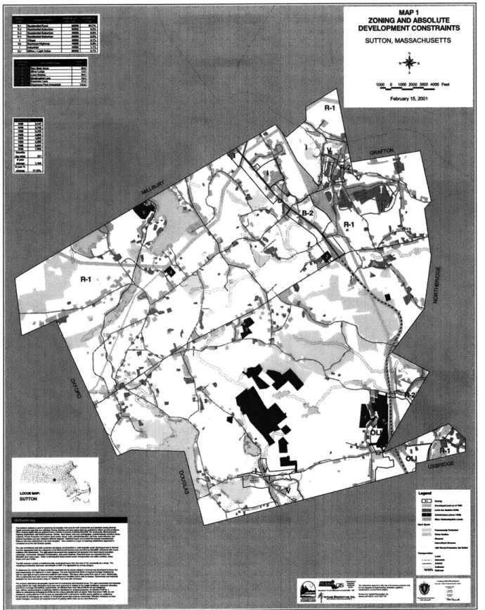
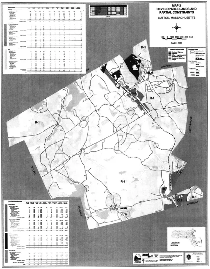
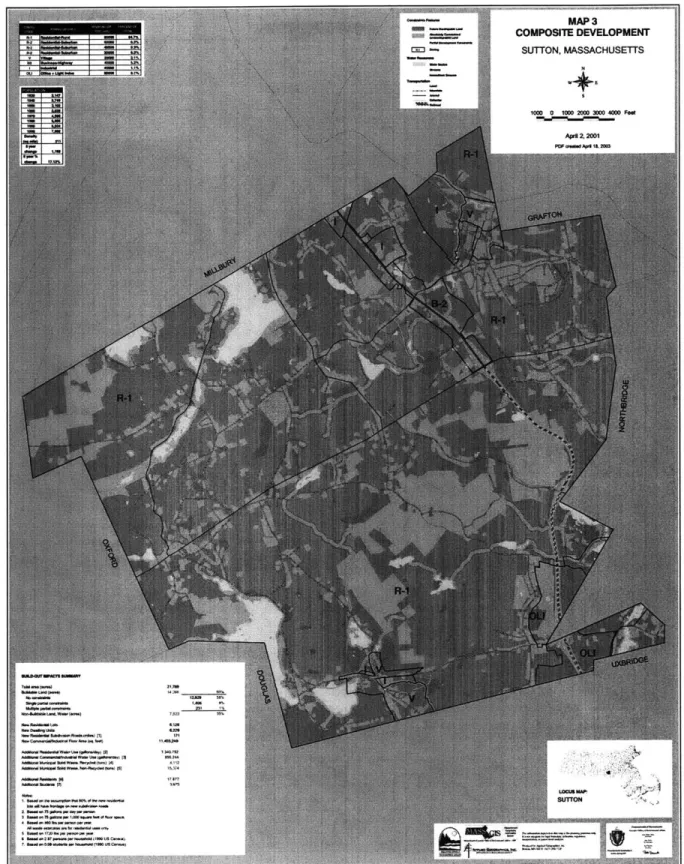
Chapter 3: A Study of Regional Growth Planning: the MassGIS CPI buildout analysis ... 49
Policy Background... 50
Process... 52
The m axim um buildout envelope- Zoning (step 1)... ... ... 53
Current buildout- Land use and Subdivisions (step 2) ... 54
A bsolute constraints to developm ent (step 3)... 55
Partial constraints to development (step 4)... 56
Buildout com putation (step 5) ... 57
The results ... 58
K ey Concepts & System ic Problem s ... 63
Sim ple m ath ... 64
Extensive data requirem ents, from m ultiple agencies ... 65
Zom bie data... 66
Stakeholder participation ... 67
Interactive end-product... 68
N ext steps ... 70
Chapter 4. Sharing D ata through W eb Services... 73
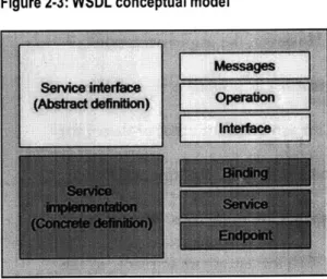
W SD L ... 74
Basic D ata Sharing: one Shapefile ... 75
Professional D ata Sharing... ... 78
M etadata ... 79
Object inheritance, and sharing multiple files through a single service ... 81
Sharing data in m ultiple form ats... 87
Sp atial data typ in g issues ... 89
P erfo rm an ce issu es ... 93
Chapter 5. Web Services for Collaborative Modeling and Decision Making...97
Computing design patterns for distributed W eb services... 97
Supporting legacy, or "black box" systems... 104
Collaborative planning: linking models with decision makers ... 105
Chapter 6. Prototyping the Buildout Analysis ... 109
Z o m b ie d ata ... 10 9 Stakeholder participation ... 116
C ollab o rativ e P lan n ing ... 118
M achine-to-machine interaction... 126
Interactive End Products...128
V isual m o d elin g ... 130
Non-technical user interfaces... 134
Chapter 7. Reflections, Critiques, and Future Directions ... 141
Critiquing the PAM ML vocabulary... 143
Exploring the nature of Web services as contracts... 147
Further implications for the planning profession ... 149
Democratizing urban design...149
Enabling community statistical systems... 151
Appendix A. Planning Analysis and Modeling Markup Language XML Schema ... 155
Appendix B. Glossary... 178
Chapter 1.
Introduction
The way planners gather and analyze information is archaic and extremely expensive. It has been this way for decades, and unlike other industries, it does not seem to be getting cheaper. Until the planning information systems community addresses this problem in a holistic manner, data-based analysis will never fulfill its potential to inform urban planning.
Few ever dispute the common folklore that 80-percent of any analysis effort is spent gathering data, leaving 20-percent of one's resources for the actual work that needs to get done. This is not a new realization. At least ten years ago we believed that the rapid increase in GIS adoption, and the ubiquity of data in electronic form, would lead to lower data sharing costs (Obermeyer and Perloff 1994). However, there is no evidence
that this occurred. In fairness, the quality and quantity of the data brought to bear on a problem has improved dramatically, but the most important factor-the relevance of analysis in the decision making process, leaves much to be desired. The reason is simple. Analysis is not timely. For example, if it takes years to assemble the data for a large
environmental impact study, is it not likely that the analysis will be irrelevant before it is presented? And once this analysis is put in front of decision makers, how extensive is Raj R. Singh Collaborative Urban Information Sjystems: A Web Services Approach page 7
their ability to provide feedback? Can someone propose, for example, an alternative economic strategy based on tourism instead of riverboat gambling and generate a new,
1,000-page report? Or is stakeholder feedback relegated to meetings and minutes, never being explicitly linked to the numbers it discusses?
This thesis argues that our data gathering practices are broken, and are not likely to improve until significant structural changes are made to urban information management
systems. The traditional areas in which we focus our research-data modeling, analysis, and visualization-are developed far beyond the capacity of practitioners to use them. The software that does such a good job with those tasks does little to facilitate basic data acquisition and processing. We have for too long overlooked the medieval data gathering practices common at all levels of government. Corporations have moved into the 21" century with integrated information systems that connect businesses with upstream and downstream trading partners, so that data is no longer re-processed when it moves from one organization to another. The planning community, on the other hand, still operates like traders at a bazaar, making deals, bartering, mixing and matching the data sources that form the foundation of our analytic systems.
Improving the flow of data between and within organizations is the next great challenge for planning support systems (PSS). With the sheer quantity of information
sources available to planners increasing every year, and the dramatic technology
investments made in the late 1990s, this is an especially important time to re-examine the ability of information technology to inform decision making in planning. What we really must do is re-evaluate what it means to be in the practice of creating planning support systems. It does not mean to combine theory, data and a methodology into aplan of
Collaborative Urban Information Systems: A Web Services Approach
action for a specific place and time. It means to create systems that provide stakeholders with the ability to continuously make plans (Hopkins 1999), have them pre-empted by others' actions, and re-plan based on the new conditions. A system that did this would truly aid the decision making process and completely change the debate around how information and specialists are used in the planning process.
Motivation and Background
Over the last ten years, few technologies have captured the interest and energy of information technology professionals like XML1 and Web services. Recently the fruits of this investment have been seen in public-facing applications like new interfaces to the databases of Google and Amazon. But perhaps more important are the XML and Web service-driven applications buried in the corporate back-office IT infrastructure, seamlessly connecting them with their business partners, and allowing them to achieve operational efficiencies that were barely imaginable in the 1980s. This is how Amazon can sell you a used book from a small, independent bookstore in Allentown, PA for two dollars and still make a profit. This is how Wal-Mart can continuously adjust their prices and inventories to meet changing supply and demand and respond to the vagaries of consumer preference. What can planners learn from Amazon? That question is central to this thesis.
'All acronyms are defined in Appendix B.
Collaborative Urban Information Systems: A Web Services Approach
Leveraging important technology trends
The research agenda of this paper is inextricably linked to a number of fundamental changes happening in how government collects, stores and distributes data, and how Internet-aware software is built. While planning cannot adopt corporate technology wholesale, we do not have the financial resources to develop our own basic technologies from scratch, like the military industry. This puts us in the precarious position of
strategically choosing which technologies to adopt from other fields, and which ones we should develop ourselves. I list here some of the trends I believe PSS must follow and adopt to be successful in the next few decades.
An urban information explosion. There is more to solving planning issues than simply obtaining the right data, but it is certainly fair to say that information plays a key role in an effective planning support system. What exactly is this role? How do we conceptualize our information processing requirements? These issues are more
important than ever as we enter an era where almost every device will have the capacity to contribute to the city's information undercurrent. The new standard for Internet addressing, IPv6, was created to greatly increase the number of IP addresses available in response to industry's desire to give unique Internet IDs to devices other than full-fledged computers. This standard is already in place and in use. Wireless Internet access is becoming increasingly common and is beginning to play a role in public sector
computing (Muniwireless 2004). Hardware for wireless Internet access is less than $10 as
of
June,
2004. These three trends taken together make it probable that even low-cost devices such as phones, cameras, buses, watches, traffic sensors, air quality monitors, etc.will be Internet-aware and addressable in the near future, leading to an exponential increase the quantity of information available about the urban landscape.
Geographic data sharing and systems interoperability. Efforts to standardize the way in which we describe geographic features are critical to our ability to share government data between different departments, levels of government, and commercial and educational institutions. For example, if all municipalities called parcels by the same name and used the same terminology-and meaning-for a parcel's attributes, the cost of regional planning and administrative operations would be greatly reduced. In Europe, the problem has been less acute as most data collection occurs at the federal level. Therefore, work in this area is mainly happening in North America, where there is a strong tradition of local independence from federal control. The U.S Federal Geographic Data Committee and ESRI have strong programs in place to promote a common
description of the most basic data sets used in government.
Of equal importance is the ability to locate and ingest another party's data with little or no human intervention in the conversion process. This is systems interoperabiliy. The OpenGIS Consortium's standards for geographic data encoding (GML/Geography Markup Language), geographic data publishing (WFS/Web Feature Service), and map publishing (WMS/Web Mapping Service) are being well received in the industry and provide one of the foundations upon which this work depends.
XML. Arguably the most disruptive technology since the advent of the World Wide Web is Extensible Markup Language, or XML. XML is really nothing by itself. It is simply a framework in which to write highly structured languages for describing things and passing messages between computers. It is also very important that XML languages
Collaborative Urban Information Sptems: A Web Services Approach
are plain text, so that their content is transparent to humans, even in the absence of computer programs that can read and manipulate the XML. This has a profound effect on people's trust in the content and in the ability of the content to be used in almost all current and future computing environments.
Web services. "Web services" is an umbrella term to describe systems that allow applications to communicate between computers using XML as a messaging language. The different communication implementation strategies go by many names (the most well known being SOAP, or Simple Object Access Protocol). However, the
implementation strategies are not important in this context. What is most important is that all Web services strategies use a well-known and widely implemented Internet protocol for communication-HTTP-the foundation upon which all Web sites operate. While some technologists decry the drawbacks of the Web protocol, the advantages are numerous. The most obvious is that most organizations already have a Web infrastructure in place, so implementing Web services can be handled in a familiar way, and the wealth of Web software can be used to develop and run new Web service-based applications. The other important aspect of Web services is that they use XML for passing messages between computers, preserving the transparency that has made XML
so popular and useful (although some implementations, most notably those promoted by Microsoft in their .NET framework, often still hide the actual message content (data) in
a non-human readable format).
Whether or not XML is better than other technologies, the software industry has quickly supported it, building powerful, reliable tools to read XML and develop Web Services on every operating system and application in common use. Perhaps the
Collaborative Urban Information Systems: A Web Services Approach
strongest sign of XML's importance is that Microsoft, which does not have a strong reputation for encouraging interoperability with others' applications, has decided to base their enterprise development software on Web Services, and has changed the native file formats of Office documents to XML.
Reflecting on the science of GIS
How do we explain geographical phenomena through the application of appropriate methods of analysis, and models ofphysical and human processes? Under what circumstances is the scientist willing to trust data that he or she did not collect, and will the increased technological abili to share scientific data over the Internet... change them? Such questions about tools often have their roots in theoretical questions about appropriate representations, operations, and concepts.
-Goodchild, et al., IJGIS 1999
These fundamental questions are posed in a 1999 article co-authored by many of the elder states-people of the field, including Mike Goodchild, Max Egenhofer and Karen Kemp. One might suppose that thirty years into the evolution of GIS these issues would have been discussed in great depth. Yet the article introduces an initiative funded by the National Science Foundation, Project Varenius, which seeks to build the theoretical foundation of geographic information sciences that was neglected during decades of practice-oriented work.
This project, while concretely grounded in a prototype implementation, fits well into the research agenda expressed by Project Varenius. It provides a set of circumstances under which scientists (and engineers and planners) can share data and collaborate on analysis. We do not hope to provide the definitive solution-that will take years of work
Collaborative Urban Information Sjystems: A Web Services Approach
by our community of researchers. The main goal is to encourage the field to step back and address fundamental, broad-based data management problems that must not be left to the fields of management information and computer sciences.
An Organizational Theory of Planning Support Systems
The field of planning support systems is defined as, "a conception of integrated systems of information and software which bring the three components of traditional decision support systems-information, models, and visualization-into the public realm" (Klosterman 1999). While Klosterman's three components have been well researched over the last two decades, work on integration has not received
proper
attention, especially in regard to the organizational setting through which information flows. This section discusses the dominant information management paradigms planners currently use, and the primary ways researchers have attempted to address shortcomings in the effectiveness of collaborative information systems. We see a mismatch betweenthe problems we would like to solve, and the strategies employed to solve them, and we posit that this is why truly effective solutions have proven elusive. To address these systemic problems, it may be necessary to develop a technology strategy based upon a different theory of information sharing across organizations. This section develops such a theory, which informs the technology framework that is the topic of this work.
Dominant information management paradigms
The most basic information management paradigm is the single user system, where everyone manages their own copy of information for their own purposes. This strategy quickly falls apart in organizational settings, where productivity gains can be had by
Collaborative Urban Information Systems: A Web Services Approacb
centralizing data collection and management activities. This leads to a situation where data are in one place, and users are in many other places. This problem has been
addressed using client-server information architectures. The central principle here is that data resides on a server, and multiple, heterogeneous clients all access a particular data set from that server. Over the past few decades this strategy has worked well. It fits (and perhaps has even influenced) the structure of many organizations, who try to centralize specialized activities like information technology in one department. Data producers are able to write, or publish, data into the centralized database server (data entry or
publishing clients), and data users are able to read data out of the centralized system. There is no direct connection between data producers and users in this type of setup.
The client-server strategy is usually only employed within a single organization, because allowing users direct access to one's database is a potential security problem, and the system often requires some training and knowledge on the part of the user. In the
1990s,
Web-based
clients came into vogue. Data was more secure-databaseconnection information was hidden from the user and buried in the Web server, and the database accessed through the Web was usually a duplicate, expendable version. Data usage and interpretation was also made simpler by using the increasingly familiar
metaphor of the Web page for information presentation and manipulation. The security advantages of Web-based systems are clear, but the benefits of Web-based client
software is less so. In the 1990s, when these technologies were being developed, users often had little experience with computing, so the Web strategy made sense. But in the near future, if not today, information users will have a sophisticated understanding of software user interfaces, and feel limited by the simplicity of Web-based clients. So while
Collaborative Urban Information Systems: A Web Services Approach
Web-based clients have taught us a lot about addressing security concerns, Web pages may be reaching the limits of their usefulness as client software. Also, the Web has little
to tell us about collaboration. The client-server paradigm has not changed, so there is no reason to expect the traditional Web server-Web page architecture to lead to
revolutionary advances in information management and collaboration.
Geographic information sharing research
There already exists a strong body of literature in the area of geographic information sharing. The traditional line of inquiry researchers often take is to examine existing organizations and their efforts at collaboration (Evans, 1997) in an attempt to understand why goals are not better met. The most general problem is that
organizational settings are highly complex. When embarking on an information sharing project, many issues may arise, such as reluctance to share GIS files due to a fear of losing autonomy, control over information sources, independence, organizational power, cost, complex inter-organizational interdependencies, and politics (Nedovic-Budic and Pinto, 1999-2, 54). Solutions to these problems usually address the social, political and organizational problems using an existing technology, or at best a new technology within an existing paradigm. On the other hand, research in planning support systems is usually geared towards technology that advances the state of the art in one of Klosterman's three pillars, with no formal attention devoted to how the technology addresses
organizational issues. By considering technology fixed, information sharing researchers are led to false conclusions. For example, it has been found that the information sharing success is found when the parties have aligned interests and work well together. What about those organizations who do not have well-aligned goals; do we expect them to
Collaborative Urban Information Systems: A Web Services Approach
never collaborate successfully? Is this an acceptable situation in planning? If we can only expect to build successful information sharing systems in that type of environment, we can never expect to change the balance of the 80-20 data management-analysis split.
Positioning PSS in the Theory of the Firm
We believe that technology research can do more to aid information sharing than the current dominant information management paradigms allow. Above all other problems, the geographic information sharing research community identifies cost as the main barrier to successful projects. While some people express a desire to collaborate
motivated by altruism and efficient government, the cost in time, resources, and money to one's own organization, in conjunction with the value derived, most often determines participation and long-term success (Nedovic-Budic and Pinto 1999-1). So then if economic concerns drive behavior, then traditional economic theory should have much to offer the urban planning field. From this perspective, we can restate the information sharing problem as one in which the costs of the system must be less than the benefits. We know that the costs of data management and sharing are high enough so that the literature advises us that the benefits must be very high to achieve successful outcomes. The goal of technology work in this area is therefore distilled to a simple principle. The lower the cost of participation in a system, the less an organization must benefit from participation. And as benefits increase, so can cost. A large state organization whose mandate is information delivery can spend a great deal of money to accomplish this goal. However, a small non-profit whose primary mission is economic development and housing has limited time, resources and interest to devote to the issue. Yet both these groups, and many in between, must be accommodated within the same framework if the
Collaborative Urban Information Systems: A Web Services Approach
technology of information sharing is to address the entire community that planners must serve.
Many in our field are uncomfortable with comparing government to corporate operations because of their different goals and motivations. However, they are more similar than different, as private sector firms have information management demands (and standards) at least as high as state and local government. We can learn a great deal from the business literature if we simply agree that both private and public agencies are groups of people organized to accomplish certain tasks in a cost-effective manner. Such is the case whether the tasks performed are part of a beer advertising campaign or a journey-to-work study. This viewpoint is not novel. Our term of art, planning support systems (PSS), is a direct descendant of the corporate term, decision support systems
(DSS), that came into vogue in the 1980s (Klosterman 1999), and most researchers have believed for a long time that GIS should ultimately be part of MIS (Obermeyer and
Pinto 1994). So we have always looked to our larger corporate brethren for guidance on how to use information to our advantage. In upcoming chapters we update that strategy and seek to assimilate PSS into the mainstream of distributed information technology, but here we provide the theoretical foundation needed to choose the right technology.
The theory presented here is built up by first specifying a strict definition of the types of roles information plays in planning support systems. Then, we propose a way to approach the problems conceptually. The only assumption made is that organizational behavior is the lens through which these problems should be viewed. Other issues, such as technology, are secondary to this. By developing an understanding of the nature of planning-related information and the organizational behaviors we must encourage to
Collaborative Urban Information Systems: A Web Services Approach
improve our systems, a framework for PSS information management can then be developed.
PSS from an information processing perspective
Most planning support systems are reticent to admit that their purpose is to quantify planning problems. Instead their proponents hedge, stating that they are no more than a platform for public debate. If the creators of these systems really felt that way, would they put so much thought into their methodology, and effort into data processing? Or is it rather the case that most analyses have such a short shelf life that their cost must be justified in some other way than their ability to provide answers? I would argue that it is the latter, and whether it is called an answer, or a model, or a simplification of a complex system, anyone working in the field of PSS must operate under the assumption that they are creating systems that process data into more easily comprehensible information to help people interpret a complex reality that is beyond the ability of any single individual, corporation or special interest group to understand.
Planning support systems do provide answers through a process that quantifies most inputs, but they are always going to be at an intermediate level. They are no substitute
for decisions. Therefore the PSS primarily exists to process information in ways that make
it easier for people to make decisions-to understand issues and engage in highly informed debate, ideally in a collaborative environment. This is not to say that the analysis and presentation of information is not important, just that those functions are well studied, and advanced far beyond our ability to populate them with useful data (in fact, if this work is successful, someone might be writing ten years from now that PSS should be seen as an information presentation tool, because they will take for granted the Raj R. Singh Collaborative Urban Information Systems: A Web Services Approach page 19
richness of information available for presentation). But no analysis or presentation or public participation can happen without a rich warehouse of information upon which to work.
The complexity of modern cities contributed to the need for the profession of planning, so it should be apparent that the information systems planners use should help
cope with this complexity. Although we are in an, "information rich era in which high volumes of data flow through ubiquitous communication networks (Evans and Ferreira
1995), current practices are not able to make use of it, at least not in a cost-effective manner. In fact, organizations usually resist distributed processing efforts (Meredith 1995), leading to high project costs with little return. This problem will likely become even more noticeable as we try to take advantage of all the environmental sensing equipment embedded in the urban landscape, from security cameras to camera phones and location-tracked transit vehicles, the data sources we can and should incorporate into PSS will increase exponentially in the near future.
It is difficult to argue against the current systems, because the lack of any universal practice or system is more notable than anything else. How do planners manage data? Basically they acquire it, process it in some idiosyncratic way to get it into their database. While there are some standard software packages in use, and plenty of "best practices" available to cite, there are precious few ubiquitous practices. When practices become ubiquitous and generic enough that unrelated organizations can develop connections between their information systems, we have achieved interoperability. And that is the point of this work, to define the general, interoperable, practices that software packages must implement if we are to have any hope of making better use of the information available
Collaborative Urban Information Systems: A Web Services Approach
today, and the immense increase in quantity and disparity of information that will be available tomorrow.
The primary raw material needed to create an analysis product is information. This information could be obtained by developing in-house data gathering capabilities, but the cost of that effort is beyond most organizations. Imagine sending teams of city planners (even if they were graduate students) out into the field to count traffic, go door to door asking people how much money they make, or how much they paid for their house. Why do this when organizations like the assessing department, the US Census Bureau, the Bureau of Labor Statistics, the realtor's Multiple Listing Service, and the actuarial databases of all kinds of insurance companies already have the information? It makes much more sense to form partnerships with these groups, and only develop custom data sets when absolutely necessary. For this reason, theproduction ofplanning analysis depends
upon inputs from multiple, disparate suppliers.
So ultimately, to make use of a large body of data, it will be necessary to work with multiple, disparate suppliers. But it may be easier to start by looking only at the case of a municipal planning effort using solely municipal data sources. What is the private sector analog to a town? Is a town a firm or a conglomerate? This is where things get slightly complicated. Most of a town planner's information providers are other municipal agencies, such as property assessing, building permitting or zoning, so it is tempting to look at municipal government as one firm with different departments that support the development of different products, like tax bills, parking tickets, police officers, drinking water, etc. However, in practice a government bureaucracy operates more like a
multidivisionalfirm than a company in the normal sense.
Collaborative Urban Information Sjystems: A Web Services Approach
Multidivisional, or M-form, firms have many unique characteristics, but for our purposes the critical one is that the reward and decision making systems are constrained within a division, so that there is little incentive for one division to act in the best
interests of another (Carlton and Perloff 1990). Some opportunities are lost this way, but at least the organization does not collapse under its own weight (Ba and Stallaert 2002). At the state and federal level, this probably makes a lot of sense because the information and coordination required to operate such large organizations is overwhelming, but municipalities may be emulating their larger relatives, without much thought paid to the reason. This theory suggests that one solution to this problem (and perhaps to many other problems) could be to institute more hierarchical forms of local and county government so that all divisions operate under a unified risk and reward structure. However, the task at hand is to redesign information systems, not government. So we will work within the given institutional parameters, which suggest that it is best to consider a local government as a multidivisional firm, and that it will stay that way in the future.
So town planners cannot count on other departments to act as partners in the
creation of their product. In other words, the assessing department has little to gain from reducing costs in the planning department. We are left with a situation where, from an ownership perspective (either as a stockholder or taxpayer), we would like to see our government maximize production across all divisions (e.g. assess property values and undertake planning analysis). However, the organizational structure cannot change, and by the definition of a multidivisional firm, the highest levels of the firm are not provided with enough information to tell the divisions exactly what to do. This is a vexing problem,
Collaborative Urban Information Systems: A Web Services Approach
and I believe it provides a good model of reality. In fact, this may be why we have so much trouble developing effective planning support systems-because we believe the government to operate like a single, unified firm.
When faced with the question of how to incorporate property value information into a planning support system, the PSS community has generally addressed the technical issues and assumed away the organizational ones. This would be fine if the
organizational issues could be treated in isolation, but they are intertwined with
technology. For example, since the 1990s, the trend in GIS has been to put data into an "enterprise" warehouse. "Enterprise" means that the data maintained by an organization (enterprise) resides in a centrally maintained database, with clients connecting over a network, and accessing those data sets a database administrator has granted them permission to use. This is fine as an intra-divisional solution, but the M-form theory suggests that enterprise databases find it difficult to cross divisions, and therefore enterprise solutions do little to address information management issues that cross divisional boundaries (Carlton and Perloff 1990). The theory is borne out by recent empirical data such as the following example. In a recent survey of 110 companies with revenue of at least $500 million, only 23% had their entire firm using one instance of ERP (enterprise resource planning) software.2 And in one extreme example, as many as 400 different versions of a single vendor's ERP software were in use at a single, large company (Kock 2004).
2 ERP is a term used to describe the process of managing an organization. The software usually keeps track of
company-wide information regarding employees, facilities, etc. Unlike software used to achieve business objectives (like customer relationship management software), which might naturally be specialized for certain divisions or functions, one would expect enterprise resource planning operations to be easily centralized.
Examining local government from the perspective of an M-form, or multidivisional firm, provides some insight into past information management failings, but remember that a discussion of a municipality's relationship to other organizations was postponed. It is now quite easy to return to that issue, because our theory already considers different divisions as basically acting like different firms. Conceptualizing government as a multidivisional firm makes it easy to incorporate other levels of government, non-governmental entities, and even private firms. And later it will be shown that the theory
suits not only the case when the analyst is a government entity, but the more realistic case when the analyst is a private entity working in loose collaboration with government, their own firm, and the public. There is no change required at the broadest theoretical level, although in practice minor differences will emerge-most likely around tighter data
privacy requirements and perhaps higher costs and information licensing restrictions. While the differences between separate firms and different divisions within the same firm might be important in some ways, for the purposes of looking at how they share and process information, it is most useful to consider their relationship to be that of
trading partners.
The way trading partners exchange information is by executing a contract. This is a
tremendously important point. A contract is a specification of all the rules governing a business transaction between parties. A contract is needed when the parties doing business cannot count on each other to maximize performance without one (this is basically any time when the two parties have different bosses). The contract must anticipate and specify what happens in all possible scenarios, because if you could count
Collaborative Urban Information Systems: A Web Services Approacb
on the parties to behave properly in a situation not covered by the contract, the contract would not have been needed in the first place. While subcontracting and outsourcing continue to be cost-effective ways of doing business, this description of contracts begins to suggest how they can become quite expensive.
The cost of doing business with outside parties is addressed in a number of
organizational behavior theories, most notably "Agency Theory" and "Transaction Cost Theory" (Vibert 2004). These theories help us decide when to outsource and when to keep a function in-house. Transaction costs have been identified as a key factor in geographic information sharing (Nedovic-Budic 1999), and being able to accurately predict these costs, and develop contractual agreements that govern the process, help ensure project success. Overall, cross-organization information sharing can achieve
economies of scale, so planners should continue to outsource their data development needs, but these theories tell us that we still must put contracts in place. Even when
cross-agency cooperation seems strong, tools like Memorandums of Understanding (MOUs) should be employed to ensure good results. What should these MOUs contain? This is where PSS research can inform policy. No treatment ofplanning support systems is
complete without attention paid to the rules by which information is transacted across agencies. Either
this policy work must be done for every PSS proposed, or the PSS must leverage a broader technology framework that has already accounted for these issues. This subtle interplay between technology and policy is a large part of the motivation for this work.
Framing the Issues from a Firm's Perspective
With a basic theory in place about PSS and its place in local government, we can begin to address the problems raised in the introduction. Planning analysis still has Raj R. Singh Collaborative Urban Information Systems: A Web Services Approach page 25
relatively little influence on development when compared to highly deterministic tools like zoning and the transportation manual, which seem to single-handedly (along with developers' interpretation/manipulation of them) shape urban form. But we cannot seek to emulate zoning or engineering manuals. They are different kinds of tools. They are one generation downstream, offering patterns or heuristics to follow. We must operate upstream, providing the guidance by which these heuristics are created, or by which they are accepted or rejected at the time of decision making.
Data, data, data
In real estate, the three most important characteristics of a property are location, location and location. Planning analysts have a similar love affair, but with data. Urban environments have become such incredibly complex organisms that no single person or agency has enough knowledge to make responsible decisions. Instead we rely on a web of specialized disciplines to build and maintain the databases and analytic tools we bring to bear on planning problems. The cost of gathering and processing this data is arguably the most significant cost for planning analysis. In rare cases, one might undertake one's own data collection effort, such as a survey. But this only happens in research
environments. The general case is one where practicing planners build their analysis around data that is readily available, and unless society develops the willingness to fund planning research (like we do in defense), this will continue to be the case. The point here is that planners are not data producers. We operate like traders at a bazaar, making deals, bartering, mixing and matching the data sources that build our analytic systems. I hope I have evoked a mental image of planners shuttling between medieval tents on muddy roads, because that is the state of civic information systems.
Collaborative Urban Information Systems: A Web Services Approach
Information technology has certainly brought significant improvements to the speed and cost of creating and maintaining data, but we are still far from being good at
bringing information to bear on a problem at the precise time when decisions are being made. In most urban information systems data comes from a variety of public and private sources, and can quickly became outdated. In the case of government agencies, whether at the federal, state, or local level, data is usually easy to acquire at any particular point in time, but difficult to keep current at all times. We often try to supplement government data with more current data from the private sector. For example, in urban growth studies, the most up to date source for new construction and land use is the developers building them. But there are no generally accepted best practices for integrating public and private data sources in a PSS, and without policy in place, we
cannot expect anything more than ad hoc participation from the private sector.
Agency theory suggests that the data provision issues can be improved by having the concerned parties execute a contract specifying exactly the rules of engagement. This may sound simple, but this type of contract is rare. Most data sharing agreements do a good job of detailing what will be shared, but not how. This is probably because it is seen as going beyond the boundaries of politeness to tell another agency how to do their job. Yet who will tell them how to do it? In a multidivisional firm, we have learned that the "bosses" are prevented from having enough information to do this, so the
appropriate rules must come out of a negotiation process between the interested parties; in other words, a contract.
So what should the contract say? One could image, for example, a program that could compare an old data set to a new one and make suitable updates. In this case, the
Collaborative Urban Information Systems: A Web Services Approach
contract might say that a new data set will be provided whenever a change is made. If the data are large, however, this could be a very wasteful way of doing things. It would make more sense to write a piece of software that could receive messages telling it to update a particular data set in a particular way. In this case, the contract could specify that the data provider's software send messages to this new, smart piece of software. This puts a burden on the data provider, but the user could compensate them with the money saved from not having to do data updates any more. And the provider would be much more likely to agree if they could re-use the updating system (and the contract) with other users. Now the interplay between technology and policy should be becoming clear. In
order for data users to solve their information management problems, they need to develop detailed, clear relationships with data providers. This clarity must be evident in contractual terms, public policy, and technological execution.
The timing of decision making
Planning support systems, like decision support systems, are tools. Their intent is not to produce maps and figures for annual reports, but to be ready partners in the process of decision making. Fulfilling this role requires that PSS must be operated by stakeholders at
the time when decisions are being made. Current practice is for technicians to operate the
system, and the usefulness of its results is usually tied closely to the time at which the data were acquired, or the analyses were run. In the Buildout analysis, we will see that MassGIS valiantly attempts to address this issue by providing online access to the analysis. This shows that they recognize the problem, but without up-to-date data, the fact that the analysis is available to a larger population does little to inform public debate.
Collaborative Urban Information Systems: A Web Services Approach
At this point in the discussion, many studies of planning information systems tend to dive into the contentious arena of public participation and get diverted by issues of politics, power and class. "Rational," information-based decision making
processes
might be mentioned as a marginalized form of discourse, or even as a tool of the wealthyto erect a fagade of objectivity around questionable decisions. This paper takes a slightly different position, and suggests that people's main motivation to use rational scientific analysis is honest; they genuinely believe in its power to inform good decisions. It is more productive to take the position that our community of information scientists provides the public realm with poor decision making tools. Our analytic methodologies are usually sound, but we have done little to adapt them to realistic decision making
scenarios. Maybe the academic, prototyping environment in which our technologies are developed are to blame, or maybe there is some other cause, but systems that depend upon pre-prepared, static data sets have extremely limited value. And there seems to be a tacit understanding of this, leading to a general dissatisfaction with most urban
information systems. Doing nothing but improving the timing of analysis would
revolutionize the field, but achieving that goal requires the other changes discussed here as well.
The timing of expenditures
A finance expert will tell you that the predictability and non-volatility of an expense is just as important as its actual amount. "Lumpy" expenses are bad, because it is
difficult to budget for them. The preference for stable receipts and payments can be seen in many facets of the economy. This is why companies are willing to pay more to lease equipment, and people can be driven bankrupt by an ill-timed
job
loss. Planners also canCollaborative Urban Information Systems: A Web Services Approach
ill afford lumpy expenses. We may go to our city council or governor and ask for a fourfold budget increase, just for the next couple of years to develop a twenty year master plan, but if conditions change, and in five years that plan is no longer valid, the money will not
be there to re-do the work. A world that changes in complex ways at unpredictable times requires continuous planning and analysis. Yet the nature of public expenditures
demands constancy and predictability. So the cost of performing planning analysis must reconcile these conflicting forces. The Buildout analysis suffers greatly from this
problem. A great deal of good work is obsolete soon after it is complete. While policy may take the lead on this issue, any technology work in the field should also be aware of the importance of timing.
Research Question & Methods
How can planning take advantage of these cutting-edge technologies that are changing the corporate IT landscape? This question motivates the research presented here. Surely there are benefits to be had from the Web services paradigm of information flow, but do the benefits outweigh the costs of adoption? And as mentioned earlier, we must be smart about how much we adopt, and how we adapt technology to fit the needs of government and urban planning.
Proving that the future of urban information systems lies within an XML/Web
Services information paradigm is a difficult task at best-there are few tools or
precedents for proving the value of paradigm shift. Falling short of this, the best strategy is to position the field within a theoretical framework that helps explain why some issues
Collaborative Urban Information Systemns: A Web Services Approach
are successfully handled, and others remain intractable problems. Starting from the theoretical position put forth above, we make a strong case for Web services through hypothetical syllogism (Weston 1992, 51). We do this by showing that government organizational behavior is similar to corporate structures, and therefore that the solutions corporations employed to successfully address information management and
collaboration issues can be employed in planning, which includes both governmental and private sector organizations.
Thesis Organization
This chapter introduced a vexing problem. We seem to be constantly progressing in our ability to capture, store and disseminate data, but our ability to manage and make
efficient use of this information leaves much to be desired. The PSS literature focuses too heavily on the traditional specialties of data management, modeling and visualization,
paying too little attention to their integration, or issues regarding implementation within an organization. On the other hand, the information sharing literature often takes technology as a given, and seeks to address information sharing and collaborative planning issues from an organizational behavior perspective. We propose a blended approach. The major points made here about how organizations collaborate are that
transaction costs and the chain of command are important factors in the ability of
organizations to function effectively. Executive managers must have very good
information about the costs and benefits of different actions and outcomes if they hope to run their agency effectively. If an organization is too large (or inefficient) for
executives to get the information needed to make these decisions, they must cede
Collaborative Urban Information Systems: A Web Services Approach
decision making authority to lower levels. This makes small divisions effective, but magnifies cross-divisional problems-exactly the situation we observe in government today.
In Chapter 2, modern, Internet-centric, distributed information technologies are reviewed with a focus on how they address information management problems. Chapter
3 presents the Massachusetts buildout analysis, an urban growth model developed as part of the Community Preservation Initiative (CPI), an effort to better engage towns in
planning for growth management and open space preservation. The CPI is interesting in itself, and is discussed in more detail elsewhere (Hodges 2004), but here we look only at the buildout analysis in its role as a practical tool with great potential, but limited
usefulness, because it suffers from the problems predicted by the theories put forth in Chapters 1 and 2.
With this background, we are able to design a new framework for urban information management. Chapters 4 and 5 present solutions to common PSS requirements such as data sharing, participatory decision making, and expert collaboration. These solutions are expressed within a Web services framework, which uses a shared, formal, XML-based vocabulary called PAMML (Planning Analysis and Modeling Markup Language). The PAMML framework consists of a language in which abstract data sharing, transformations
(arithmetic operations, format translations) and publicfeedback loops can be expressed, and a suite of Web services that allow organizations to advertise their ability to perform specific tasks, such as the transfer of a particular data set, or the execution of a particular spatial operation. The entire PAMML vocabulary is expressed in the XML Schema language, and is listed in Appendix A.
Collaborative Urban Information Systems: A Web Services Approach
The theoretical argument is strengthened by reference to an example of a real
planning support system being used in Massachusetts. Armed with a theory and an actual system that exhibits shortcomings common to its kind, the thesis presents a solution based on XML and Web Services. As stated, there is no definitive way to unequivocally
prove the system's value, but it is hoped that the preponderance of evidence presented
here should convince the reader that paradigm shift is worthwhile.
Collaborative Urban Information Systems: A Web Services Approach
Chapter 2: Technology Frameworks for Information Sharing
Information-rich analysis efforts are characterized by their struggles with data preparation. This process can take months or years to complete (Waddell 2004), creating a situation where the "dirty little secret" of information analysis is that the majority of the time and effort is spent in data acquisition and formatting. The planning profession has generally ignored this problem, considering it a software issue which will improve with time and progress in the general field of information systems. This point of view seems reasonable, but much evidence suggests otherwise. If that is the case, it would seem that we would have observed significant improvements over the last few decades, but the results are mixed. We are digitizing less data, and using more data in our analyses, yet we continue to duplicate data development efforts, and we rarely implement systems whose data stays relevant from year to year. The problem is exacerbated by the fact that the organizations information moves between have different professional cultures, goals, and skills. Administrative divisions like property assessing have little in common
culturally with the planning department, or a zoning board, or a local watershed
protection group. These communities require their own methodologies for information processing, visualization and dissemination, and any proposal for improving information integration must not put restrictions on any organization's natural operational processes. A well-known concept in decision support is the idea that our systems should help people engage in the transformation of data into information into knowledge. Our current technologies have been good at providing decision support to individuals or
Collaborative Urban Information Systems: A Web Services Approach
small groups using self-contained systems, but when the system is like most planning analyses, having multiple, heterogeneous participants in every area-from the creation of data, to the modeling, to the presentation of results-they break down under the
operational costs of the information transactions.
This situation suggests that the root causes of our data dilemma are not in what information systems or data converters we happen to use, but in defining an overall
framework for processing information. A framework is an extensible structure for
describing a set of concepts, methods, technologies, and cultural changes necessary for a complete product design and manufacturing process (CERN 2004). It is more than a set of software recommendations, or even a new technology proposal, but all those things in conjunction with the cultural and institutional changes necessary to effect real progress. This chapter presents a technology framework in which we can reduce costs, while developing urban information systems that hold up to increasing demands from participants in data input (data), information development (modeling), and knowledge creation (visualization and public participation). First, the concept of a planning support system is positioned generically as a distributed computing environment. This allows planners to leverage the systems that computer scientists have created for distributed information processing instead of inventing our own technology baseline. While there are a few alternative technologies for doing distributed computing, a Web Services
framework is chosen. This decision helps solve the next issue, which is to develop planning-specific decision support systems within the distributed computing
environment. In a Web Services framework, domain-specific information models are
Collaborative Urban Information Systems: A Web Services Approach
developed in a semantic meta-language like RDF or XML. While these tools have various pros and cons, Web Services software available today is designed to use XML,
and the practicality of using RDF has yet to be shown. In the following chapters, we adopt the Web services framework, and use it to prototype a new urban information system based on data and analysis services. This is presented through a series of use cases relating to data publishing, urban modeling, and participatory GIS where case-specific solutions are developed. Finally, a full system is presented in Chapter 7, and the MassGIS buildout analysis is presented in this new framework. The XML vocabulary is
called Planning Anaysis and Modeling Markup Language, or PAMML, and the Web Services
built on it are referred to as PAMML services.
An introduction to distributed computing
A distributed computing environment is one in which information and the
applications that make use of it are physically located on different computers. In order for these computers to know that others of their kind exist, and how to talk to them, computers need a whole host of hardware and software. For the purposes of this work, we will assume that communication occurs via what is commonly called the Internet, which includes Ethernet and TCP/IP.
Collaborative Urban Information Sjystems: A Web Services Approach
Figure 2-2:
Abstract 3-Tier Architecture
Figure 2-2:
Web 3-Tier Architecture
In this environment, an information warehouse is called a
resource, and the system that provides information is generally
called a service. So in this parlance, information, or data, is retrieved from a resource through interaction with a semice. The agent that requests information-for example a person, a computer or a computer program-is called a client. What has just been described is usually called a "three-tier architecture" in computing. This architecture underlies most of the important
systems in use today, including e-mail, instant messaging, and the World Wide Web.
In this architecture, any information store, such as a parcel database or an address book, becomes an abstract concept. The actual data can only be accessed by making a request to a service, which serves as the gatekeeper to the data. PAMML is a language that describes how to build services, so that different services can be expected to reliably interact with one another.
This architecture is quite complex and difficult to implement in practice, so why bother? The best answer is that distributed computing is flexible enough to mirror the organizational situations we encounter in the real world. For example, if everyone was required to have an email server on his or her computer and they could only read their email on that computer, it is doubtful that email would be in widespread use today. In government, our interest centers on the distributed nature of information and domain knowledge. For example, the assessing department uses parcel data more than any other
Collaborative Urban Information Systems: A Web Services Approach Page 38 Ra j R. Singh