HAL Id: insu-00726512
https://hal-insu.archives-ouvertes.fr/insu-00726512
Submitted on 30 Aug 2012
HAL is a multi-disciplinary open access
archive for the deposit and dissemination of
sci-entific research documents, whether they are
pub-lished or not. The documents may come from
teaching and research institutions in France or
abroad, or from public or private research centers.
L’archive ouverte pluridisciplinaire HAL, est
destinée au dépôt et à la diffusion de documents
scientifiques de niveau recherche, publiés ou non,
émanant des établissements d’enseignement et de
recherche français ou étrangers, des laboratoires
publics ou privés.
Arc Deformation and Marginal Basin Opening: Japan
Sea as a Case Study
Laurent Jolivet, Philippe Huchon, Xavier Le Pichon, Nicolas Chamot-Rooke,
Jean-Charles Thomas, Jean-Pierre Brun
To cite this version:
Laurent Jolivet, Philippe Huchon, Xavier Le Pichon, Nicolas Chamot-Rooke, Jean-Charles Thomas,
et al.. Arc Deformation and Marginal Basin Opening: Japan Sea as a Case Study. Journal of
Geophysical Research : Solid Earth, American Geophysical Union, 1991, 96 (B3), pp.4367-4384.
�10.1029/90JB02455�. �insu-00726512�
JOURNAL OF GEOPHYSICAL RESEARCH, VOL. 96, NO. B3, PAGES 4367-4384, MARCH 10, 1991
Arc Deformation and Marginal Basin Opening'
Japan
Sea as a Case Study
LAURENT JOL1VET AND PHlI2PPE HUCHON Ddpartement de Gd, ologie, Ecole normale supdrieure,
JEAN PIERRE BRUN
Laboratoire de Tectonique, Universitd, de Rennes I,
XAVIER LE PICHON, NICOLAS CHAMOT-ROOKE AND JEAN CHARLES THOMAS
Ddpartement de Gdologie, Ecole normale supdrieure,
We discuss the opening mechanism of the Japan Sea in Miocene time using (1) tectonic and published palcomagnetic data along the eastem margin from the north of Hokkaido Island to Sado Island, (2) a
mechanical model which is tested by small-scale physical modeling, and (3) crustal structure and
bathymetric features in the Japan Sea which constrain our kinematic model and preopening
reconstructions. Our main conclusions are the following. The eastern margin of the Japan Sea was, as a whole, a dextral shear zone about 100 km wide. This conclusion is supported by the existence of a ductile dextral shear zone in Central Hokkaido (Hidaka Mountains) and associated brittle deformation in western
Hokkaido and northeastem Honshu. The stress field during the opening (which ended about 12 Ma ago at
the end of the middle Miocene) changes from right-lateral transpression in the north to right-lateral transtension in the south. The western margin, along the Korean peninsula, during the same period, also was an active dextral shear zone. Palcomagnetic results indicate that clockwise rotations occurred in the south during the opening and counterclockwise rotations in the north. We propose a model of right-lateral pull-apart deformation with dockwise rotations of rigid blocks in the southern transtensional domain and counterclockwise rotations in the transpressional one. Small-scale physical models show that the
clockwise rotation in transtension is possible provided that the eastern boundary (Pacific side) is free of
stress. The opening stopped and compression subsequently began about 12 Ma ago. Finally, we show that the dextral shear, which is distributed over the whole Japan Sea area, is accommodated by N-S trending fight4ateral faults and rotation of blocks located between these right-lateral faults.
INTRODUCTION
Whether marginal basin opening occurs by
[Matsuda and Uyeda, 1971; Hilde et al., 1977; Chase, 1978; Uyeda and Kanamori, 1979; Taylor and Karner, 1983; Uyeda, 1986] or by extension induced along transform faults [Hamburger and Isacks, 1988] or by intracontinental deformation [Tapponnier et al., 1982; 1986; Kimura and Tamaki, 1986], it is assumed that the adjacent arc does not behave as a rigid body during the opening but, instead, suffers extensive deformation [Otofuji et al., 1985, Tamaki, 1985]. We propose in this paper a model for the Miocene opening of
we propose for the opening is tested with small-scale experiments. Finally, this model is quantified in terms of
slab retreat kinematic
reconstructions.
We do not discuss
forces
which
led
to the opening. We address the question of how the Japan Sea opened and leave aside the question of why it opened.
BACKGROUND
Two principal methods have been used to study deformation at the scale of the Japan arc. The first method characterizes the deformation where it is localized, i.e., along the major faults,
the
Japan
Sea
(Figures
1 and
2) which
is based
on
our
study
of and
describes
the
stress
and
strain
regime.
This
method
does
the deformation
over the whole
arc and published
not usually
give an estimate
of the magnitude
of the
palcomagnetic
data.
Earlier
Otofuji
et al. [1985]
proposed
that displacements
along
the
faults
because
clear
offset
markers
are
the Japan Sea opened by rotation without significant north-
soum translation of ... SOBLIIWC• tgIll •11L• 11UI
based on paleomagnetic data (see Figure 2, model 1). We oppose this "bar door" opening model for a right-lateral pull- apart model which involves rotations about a nearby pole. The geometry of a typical pull-apart supposes no "spinning" of the displaced blocks [see McKenzie, 1990]. In our model a
usually missing on both sides of the fault zone (it is indeed the case for the Japan arc). The second method uses palcomagnetic measurements within the relatively less strained blocks bounded by the major faults to obtain the amount of rotation and of latitudinal motion. These two approaches are obviously complementary.
Based on a palcomagnetic study, Kawai et a/.[1971] first concluded that Japan had been bent. All the following component of rotation about a nearby pole is added to the N-S
translation
along
the
major
strike-slip
faults.
The
mechanism
paleomagnetic
works
have
confirmed
this
early
conclusion
although significant discrepancies exist. For example, Otofuji et al. [1985] concluded that SW Japan has rotated clockwise
Copyright 1991 by the American Geophysical Union between 15 and 13 Ma by 56 ø about a pole located in the
Tsushima strait (between Kyushu and the Korea peninsula), and Paper number 90JB02455. that NE Japan (the northern part of Japan, north of the
n 148-n'•'•'•/t•, ... .
... /•,,/90JB02455505.00 Tanakura Tectonic line) has rotated rigidlv by 47 ø
4368 JOIXVKF ET AL.: ARC DEFORMATION AND MARGINAL BASIN OPENING
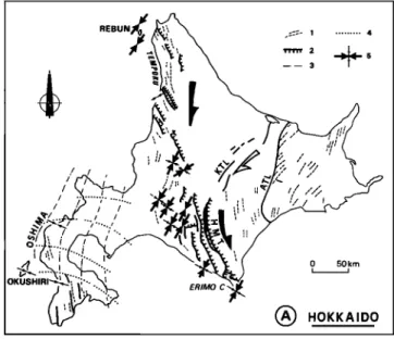
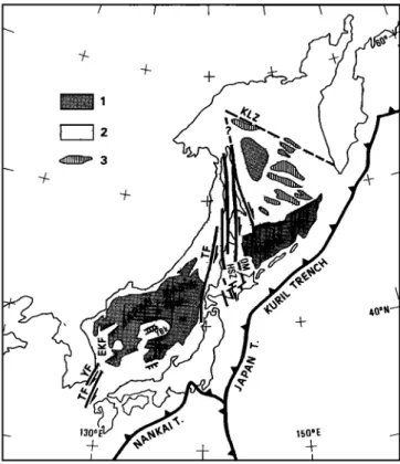
'130 • 150"E
Fig. 1. Simplified structural map of the Japan Sea and Okhotsk Sea area. Key shows (1) oceanic crust, (2) thinned continental crust, (3) outcrops of basement in the Okhotsk Sea. TF is Tartary fault, HSZ is Hidaka Shear Zone, KLZ is Kashevarov Linear Zone, YF is Yangsan fault, TF is Tsushima fault, YBk is
Yamato Bank, YBs is Yamato Basin, OM is Oki-Monbetsu Tectonic Line, and EKF is East Korean Fault.
counterclockwise about a pole located north of Hokkaido during the opening of the Japan Sea (Figure 2). According to Otofuji et a/.[1985], these large rotations were completed within less than 1 Ma about 15 Ma ago. Faure and Lalevde [1987] used correlations of preopening structures to propose a
similar model.
On the other hand, on the basis of observations of the
deformation in northern Japan and compilation of available structural data, Lallemand and Jolivet [1985] and Jolivet et al. [1989] pointed out that major right-lateral faults were active during the opening along the eastern and western margins (Hidaka mountains in Hokkaido and Yangsan Fault in South Korea). These authors proposed a right-lateral, pull-apart opening model (Figure 2). Earlier, Otsuki and Ehiro [1978] had used a similar approach, but with less data available at that time they reached a different conclusion.
There is an obvious conflict between the pull-apart model, which involves N-S translations, and the current interpretation of palcomagnetic data, which implies only rotations about nearby poles. In order to resolve this conflict, we present a threefold approach: (1) We establish better constraints on the deformation of the arc and its timing by characterization of the stress field and study of the behavior of the major faults during the opening. This allows us to propose a general model; (2) We test the mechanical :ealidity of this model using small-scale
analog experiments; (3) We propose preopening
reconstructions of the Japan Sea based on this general mechanism with constraints from the geometry of bathymetric
features.
In the initial paper proposing the pull-apart model
[Lallemand and Jolivet, 1985], the eastern margin of the Japan
Sea was described as a major right-lateral shear zone for two
reasons. First, the offshore structure shows a succession of N-S
trending ridges and troughs bounded by vertical faults in the
Tartary Strait, and right-lateral en 6chelon troughs along the
western coast of Hokkaido and northern Honshu [Antipov et al., 1980; CCOP-IOC, 1980]. Second, a right-lateral shear zone, on land, the Hidaka Shear Zone, was active during the
opening. A similar argument was used for the western margin
along the eastern coast of Korea [Kang, 1981; Reedman and Um, 1975; Schluter and Chun, 1974]. To test this proposal we analyzed the brittle deformation along the eastern margin from Hokkaido and Rebun islands in the Tartary Strait to SW Hokkaido [Jolivet and Huchon, 1989], Oga Peninsula, Nihonkoku region and Sado island (the data collected on Sado
Island are here presented for the fLrst time) using Angelier's [1984] methods. We also considered structural data concerning
the bending of Mesozoic belts in Kyushu [Murata, 1987; Fabbri eta/., 1987].
These data, together with those previously discussed show that (1) the eastern margin of the Japan Sea is a right-lateral shear zone which was active from the Oligocene (?) to Middle Miocene, (2) the stress field evolved in space from a NE-SW
horizontal compression in Hokkaido with simultaneous right- lateral and reverse displacements (right-lateral transpression)
to a NW-SE extension in the south with coexistence of right- lateral and extensional displacements (right-lateral transtension) in agreement with the initial pull-apart model,
and (3) this deformation is contemporaneous with the bending
of SW Japan in the Middle Miocene. These results, considered together with the palcomagnetic data, lead to a pull-apart model with mostly clockwise rotation to the south and
counterclockwise rotations to the north.
Small-scale physical experiments were undertaken to see (1) under which conditions rotations are allowed and (2) what sense of rotation can be expected in a right-lateral shear zone with a pull-apart basin opening . We tested the influence on the opening mechanism of the "free boundary" on the Pacific side: as suggested by Tapponnier and Molnar [1976] and Peltzer and Tapponnier [1988], the horizontal stress induced by subduction of the Pacific plate east of Asia is weak and the
subduction does not resist to the eastward extrusion of
continental blocks. We show that rotations are always clockwise, e.g., right-lateral. Rotations of small dominolike
blocks between major faults and rotation of large blocks
leading to basins opening are both observed. All these manifestations are enhanced by the presence of a free boundary. We conclude that the clockwise rotation of SW
Japan about a pole located in the Tsushima strait is compatible
in terms of mechanics with the pull-apart system. We also
conclude that the counterclockwise rotation of northeast Japan
is the result of the transpressional context there. We then propose a kinematic model which takes into account the geometry of the basins and major faults.
SUMMARY OF TttE BASIN STRUL-q75RE
The structure of the Japan Sea is described in detail by Tamaki [1988]. According to Ludwig et al. [1975], Honza
[1979] and Tamaki [1985], oceanic crust is distributed in three
deep basins (Figure 2). The largest and deepest is the Japan basin which has the shape of a parallelogram. It is located
between
the Eurasian
margin
to the north,
the Korean
margin
to the west, the Yamato Bank to the south, and the western margin of Honshu and Hokkaido to the east. Between the
Yamato bank and the island of Honshu is the 2000-m-deep
Yamato Basin. West of the Oki ridge is the Tsushima basin.
Present-day tectonics involves a nascent underthrusting of the
Japan Sea crust below the NE Japan arc [Fukao and Furumoto, 1975; Nakamura, 1983].
JOLIVET ET AL.: ARC DEFORMATION AND MARGINAL BASIN OPENING 4369 JAPAN Oga Pen. 3 4 5 ,,, • • 9 10 11
Fig. 2. Tectonic map of the Japan Sea (insert: three different models of opening, (l) Otofuji et al. [1985], (2)
Jolivet et al. [1989], (3)Lallemand and Jolivet [1985]. Key shows (1) continental blocks in the Japan Sea after Tamak/ [1986], (2) thinned continental crust, (3) oceanic crust, (4) recent infill of en 6chelon grabens on
the eastern margin of the Japan Sea, (5) onland thrusts, (6) strike of folds axes after Kimura et al. [1983], (7) active offshore thrusts after Tamaki [1988], (8) strike-slip faults, (9) normal faults, (10) subduction of the Pacific plate, (11) subduction of the Philippine Sea plate. BTL is Butsuzo Tectonic Line, HMT is Hidaka Main Thrust, HTSZ is Hidaka Tartary Shear Zone [Lallemand and Jolivet, 1985], IBR is Izu-Bonin Ridge, ISTL is Itoigawa-Shizuoka Tectonic Line, KPR is Kyushu-Palau Ridge, KTL is Kamishiyubetsu Tectonic Line [Kimura et al., 1982], kyb is Kita Yamato Bank, MTL is Median Tectonic Line, nkr is North Korean Ridge, ntb is Nishi-Tsugaru Basin, ob, is Oki Bank, ob is Okushiri Basin, or is Oki Ridge, ot is Oki Through, TF is
Tsushima Fault, 'I'TL is Tanakura Tectonic Line, skr is South Korean Ridge, st is Shiribeshi Trough, yb is Yamato bank, Y-F is Yangsan Fault, and ZR is Zenisu Ridge.
4370 JOL1VET ET AL.: ARC DEFORMATION AND MARGINAL BASIN OPENING
The magnetic structure of the basin is poorly constrained. lsezaki and Uyeda [1973], Kobayashi and lsezaki [1976], and lsezaki [1986] published contoured magnetic anomaly maps of the Japan Sea. The E-W to ENE-WSW strike of the anomalies appears clearly, at least in the Japan basin, but it is impossible to identify the anomalies with confidence. Tamaki [1988] also recognized E-W trending anomalies with a possible east to west propagation of the spreading center along strike, during a recent survey of the northern part of the Japan Sea.
The directions of the anomalies do not fit the fan shape opening of the northern Japan basin proposed by Otofuji et al. [1985] based on paleomagnetic data, which predicts fan-shaped anomalies. Instead, the spreading center seems to abut against the western margin of the Japan arc. We know that the amount of underthrusting along this margin is small [Nakamura, 1983; Tamaki and Honza, 1984], which implies that the anomalies were originaly formed perpendicular to the margin. This implies a component of strike-slip or transform along the margin.
The Yamato Bank, a rifted continental ridge, separates the Yamato and Japan Basins. The Yamato Basin is thought to be slightly younger than the Japan Basin [Hilde and Wageman, 1975]. Bathymetry and seismic profiles show that the center of the ridge is occupied by a graben trending N50øE. Several parallel grabens appear in the morphology of the northern margin of SW Japan and eastern margin of Korea. Along the eastern margin of the Yamato and Japan basins, grabens are also observed trending more northerly (N30øE). Several en •chelon troughs (Figure 2: Shiribeshi trough, Okushiri and Nishi Tsugaru Basins) and the active E-W compression [Fukao and Furumoto, 1975] have been related by Nakamura [1983] to the nascent subduction. They actually are older extensional structures reworked by the recent compression [Tamaki and Honza, 1984; Lallemand et al., 1985]. One of these grabens crops out in the island of Sado (Figure 3). Here the faulting cuts Oligocene to Middle Miocene volcanics and volcanoclastics [Ganzawa, 1982] and is postdated by Late Miocene marine deposits.
A similar tectonic timing is recorded along the whole eastern and southern margins of the Japan Sea. For example, along the eastern coast of Korea, Schluter and Chun [1974] have shown offshore N-S trending faults parallel to the margin. Onland, NE-trending en 6.chelon normal faults cut the Early Miocene deposits of the Yangbug group, and are covered with the Yeonil deposits of Middle Miocene age [Lee and Pouclet, 1988; Lee, 1989]. The extensional deformation thus occurred sometime during Early and Middle Miocene. This timing is in agreement with the conclusions of Tamaki [1986] which are based on heat flow, stratigraphy, and basement depth: the Japan Sea opened during Late Oligocene to Early and Middle Miocene.
Tarnaki [1985] produced a map of the thickness of the crust in the Japan Sea. Oceanic and continental crust and strongly attenuated continental crust are shown from his data in figure 2. This is a useful guide for the preopening reconstructions.
REVIEW OF ONLAND PALEOMAONET•C DATA
SW Japan.
We shall not consider sites older than Early Tertiary in this paper. Still there is considerable argument concerning the interpretation of Early Tertiary paleomagnetic data.
Moreau et a/.[1987] concluded that a strong remagnetization event may have occurred in Miocene time, but Tosha and Hamano [1988] argued against this conclusion. A widespread sampling of Miocene tuffs show easterly declinations in SW Japan [Otofuji and Matsuda, 1983; Otofuji et al., 1983; Otofuji and Matsuda, 1984; Sasajima, 1981; Otofuji et al., 1985; Hayashida, 1986]. Otofufi et al. [1985] proposed a clockwise
rigid rotation 15 Ma ago by 56 ø about a pole located in Tsushima strait. The direction of paleomagnetic vectors are
indeed fairly consistent in the area surveyed by Otofuji et al. [1985], who are in favor of a rigid-body rotation. However the declination progressively becomes more northerly to the east
and northeast [ltoh, 1986; 1988; Itoh and lto, 1988]. Hirooka et al. [1986] proposed that independent rotations of smaller blocks may have occurred. Itoh [1988] concluded that SW
Japan had first rotated clockwise, as claimed by Otofuji et al.,
and that the eastern part of it later rotated counterclockwise to some extent due to bending of the arc along the Itoigawa-
Shizuoka Tectonic Line. Thus the magnitudes of these
rotations cannot be ascertained as we only know the resultant
rotation.
Jolivet et a/.[1989] proposed that these results could be interpreted as due to a rigid rotation of SW Japan with local
rotations due to Miocene internal deformation of the arc along the Median Tectonic Line which is a Cretaceous and Paleogene
left-lateral fault [lchikawa, 1980; Otsuki and Ehiro, 1978]. But
the Early to Middle Miocene deformation along this fault is not
well constrained and further observations are needed to
ascertain this conclusion. We shall see in the following that 30 ø of clockwise rotation of SW Japan is required to close the
basins fitting crustal features. This clockwise rotation is compatible with structural data of Kyushu Island (see below).
More recently, McCabe et al. [1988] showed that Early Miocene sites of South Korea have been rotated clockwise by
20 ø . The latter data either show local rotations east of the
right-lateral Yangsan fault (see later) or reduce the amount of
rotation of SW Japan with respect to the Korea peninsula.
NE Japan
Otofuji et al. [1985] proposed that northeast Japan rotated counterclockwise by 47 ø about a pole located north of Hokkaido 15 Ma ago. Their data were obtained along the eastern coast of the Japan Sea in Oga peninsula and Asahi mountains (Nihonkoku in figure 3). Western Asahi shows an easterly declination while eastern Asahi shows a westerly declination. They concluded that the easterly declination is due to local right-lateral rotations along the Nihonkoku-Miomote shear zone while the westerly declination is due to rigid body rotation of NE Japan. Their conclusions are mainly based on the data obtained in the Oga peninsula where a westerly
declination of rocks older than 14 Ma is observed. When
plotting all the paleomagnetic directions of the Early Miocene sites published by various aukors in NE Japan [figure 4 of Jolivet et al., 1989], these directions are not homogeneous and many sites are not rotated. Tosha [1983] and Tosha and Harnano [1988], after extensive sampling of the Oga peninsula, concluded that a fast rotation of about 20 ø occurred about 15 Ma ago. Figure 8 of their paper shows that the westerly declination decreases when the age of the sample increases. If the data are reliable this is incompatible with a rotation achieved in a single discrete stage. One must assume an early clockwise and a later counterclockwise rotation as suggested by Celaya and McCabe [1987] and Tosha and Harnano [1988] (or, alternatively, a progressive clockwise rotation by 300ø). Thus the exact amount of rotation is poorly known. In this paper we relate the counterclockwise rotation to the transpressional stress field in Hokkaido and show that a total rotation of 20 ø is compatible with the geometry of the opening.
DEFORMATION OF THE ARC DURING THE OPENING
PROCESS, FmLD APmOACI-•
In the following we summarize the smactural data gathered along the eastern margin of the Japan Sea (for detail on the
142 ø 140 ø
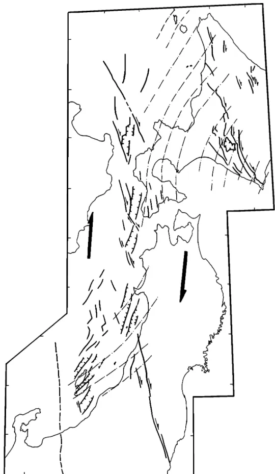
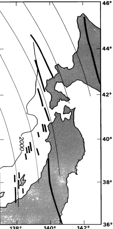
Fig. 3. Bathymetric
map of the eastern
margin
of the Japan
Sea after [Maritime
Safety
Agency
of Japan,
1980a, b) and the main onland tertiary structures [after Jolivet and Huchon, 1989; Yamaft, 1989]. IN is Iwanai nappe. Open arrows: Cretaceous motion along strike-slip faults; solid arrows' Cenozoic motion. KTL is Kamishiyubetsu Tectonic Line, OB is Okushiri Basin, NTB is Nishi Tsugaru Trough, ST is Shiribeshi Trough. Dashed curves show direction of C•Hmax during O!igocene to Middle Miocene; dashed solid curves show fold4372 JOLIVET ET AL.: ARC DEFORMATION AND MARGINAL BASIN OPENrING
deformation in the Hokkaido Central Belt see Jolivet and
Huchon [1989 and references therein]), we review published
data about other areas, and we conclude with a deformation
mechanism at the scale of the arc.
Hold•ido Central Belt
The present-day Hokkaido Central Belt (HCB, Figures 3 and 4) developed during the Cenozoic in two main stages. A major, right-lateral, N-S trending shear zone (Hidaka Mountains) was formed during Oligocene to Middle Miocene. It was followed by an E-W shortening which led to the formation of westward verging thrusts from Late Miocene to Present [Kimura et al., 1982; 1983; Jolivet and Miyashita, 1985; Kimura, 1986; Moriya, 1986; Watanabe, 1988; Jolivet and Huchon, 1989]. This Cenozoic succession of deformation postdates a Mesozoic stacking of nappes in high-pressure, low-temperature metamorphic conditions which is outside of the scope of this paper [lshizuka et al., 1983; Jolivet, 1986b]. The formation of the right-lateral Hidaka Shear Zone was coeval with the eraplacement of the Iwanai nappe [Jolivet and Huchon, 1989]
toward the south and with the formation of en 6chelon folds and
thrusts. These latter features can be followed all along the
Hokkaido Central Belt.
The analysis of the fault sets also reveals the two successive stages of deformation and allows us to date them. The younger sets cuts all the strata including the Pliocene [see Mitani, 1978; Yamagishi and Watanabe, 1986]. The deduced principal compressire stress o 1, following Angelier's [1984] method, strikes E-W. These faults are related to the recent E-W thrusting
event. The older fault set is found in all strata from Middle
Miocene downward. The principal compressive stress strikes
NE-SW which is compatible with the right-lateral shear along
the Hokkaido Central Belt. The Oligocene to Middle Miocene age of the right-lateral shear is also confirmed by the radiometric data obtained by Shibata [1968], Shibata and lshihara [1979] and Shibata et al. [1984] on synkinematic granites and migmatites in the Hidaka Mountains (40 to 17
Ma). The Hidaka Shear Zone is made of high-temperature
metamorphic rocks [Komatsu et al., 1983; Osanai et al., 1986a; b] with a vertical N-S trending foliation. The synmetamorphic strike-slip deformation reworked the original Mesozoic thrust contact between an ophiolite sequence and a granulitic basement [Jolivet, 1986a]. A high PT gradient is observed increasing from west to east [Nakano, 1981; lshizuka, 1981; Miyashita, 1983]. Throughout the zone, the foliation is vertical, except in narrow en •k:helon zones where it flattens toward the west. A conspicuous horizontal
stretching lineation, with consistent evidence of
synmetamorphic right-lateral shear, is observed everywhere. Evidence of Miocene right-lateral ductile shear was also reported by Watanabe and lwata [1985] and Watanabe [ 1988] in the northern Hidaka Belt and also by Uda [1973; 1976] in the southern part of the belt.
Jolivet and Huchon [1989] concluded that the entire Hokkaido Central Belt was a crustal-scale, transpressive, flower structure (a positive flower structure in the sense of Harding 1985] with a narrow (10 km), deep, ductile, strike-slip shear zone and a wide, shallower domain of en 6chelon thrusts and folds during the Oligocene to Middle Miocene.
East Coast of the Japan Sea
Oligocene to Middle Miocene tuffs and lavas (Green Tuffs, Ingle [1975]; Ganzawa [1982; 1983; 1987]; lijima et al., [1988]) are widely exposed along the eastern margin of the Japan Sea and record a deformation contemporaneous with the opening. From Rebun Island to Sado Island (Figures 3 and 4), the Oligocene to Middle Miocene horizontal maximum
Fig. 4. Directions of the main horizontal stresses deduced from fault sets analysis in Hokkaido and Sado. 1, strike of folds axes. Key shows (2) main thrusts, (3) direction of maximum compression [after Yamagishi and Watanabe, 1986] in the Oshima peninsula, (4) direction of minimum compression after the same authors, (5) our own data, large arrows for the main horizontal compression, narrow ones for the other main horizontal stress, compressional in (a) Hokkaido, extensional in (b) Sado, Large numbers (1 and 2) refer to the successive stages recorded in Sado when these have been clearly differentiated. The open arrow along the KTL represents the right-lateral motion active after the end of Middle Miocene. ATL is Abashiri Tectonic Line, KTL is Kamishiyubetsu
JOLIVET ET AL.: ARC DEFORMATION AND MARGINAL BASIN OPENING 4373
compressive stress 03Hmax), deduced from the analysis of
faults sets, trends NE-SW. However, this stress corresponds to the maximum compressive stress C•l in the north where the
stress regime is transpressive, while it corresponds to the intermediate stress c•2 in the south, where the stress field is
transtensive. In the north, thrusts faults and strike-slip faults are associated with folds, whereas in the south normal faults
and strike-slip faults coexist. There is a clear transition from right-lateral transpression to right-lateral transtension from north to south.
Figure 4b shows a summary of the data from Sado Island.
This island is divided in two by a graben. This is one of many grabens which are now below sea level along the eastern
margin of the Japan Sea. The tectonic data on this extensional deformation shed light on the evolution of the entire margin.
The deformation shown in Figure 4b does not affect the Late
Miocene deposits which postdate the formation of the graben.
The outcrops show the association of strike-slip and normal faults and the principal horizontal compressive stress consistently strikes NE-SW. Although the stratigraphic data are not precise enough to conclude two discrete stages, we observed at many outcrops the succession from a strike-slip movement to a normal movement with a strike-slip
component. In some cases, the earlier strike-slip faults
crosscut fiat-lying reverse faults compatible with the same direction of C•Hmax. It seems that the deformation mechanism was first transpressive then transtensive with a larger component of extension with time.
In the Oga peninsula the direction of C•Hmax was determined from a dyke swarm. We observed in several places right-lateral en 6chelon relationships between dykes as well as reverse
faults giving the direction of C•l along the N30 ø to 50øE
direction. These dykes were thus not emplaced in an extensional stress field but in a right-lateral transpressive one. Further to the south, the Cenozoic deformation is concentrated along the Cretaceous Nihonkoku-Miomote shear zone described by Otsuki and Ehiro [1978]. Like other left- lateral Cretaceous shear zones (Tanakura tectonic line) it is reactivated as right-lateral during the Cenozoic [Koshiya, 1986]. Along the coast, the basement of the Cenozoic deposits (Cretaceous granites) is cut by fiat-lying normal faults compatible with the same transtensional stress field as in Sado
Island.
Analysis of the Bathymetric Features along the Eastern Margin of the Japan Sea
Tamaki and Honza [1985], Okada et al. [1985], and Lallemand et a/.[1985] showed that the Shiribeshi trough, Okushiri basin, and Nishi-Tsugaru basin (Figures 3 and 5), presently active as compressional structures, are reactivated
extensional structures. Their en 6chelon relations, and the
tectonic history of Sado Island favor a right-lateral shear zone along the eastern margin from Oligocene to Middle Miocene.
A simple analysis of the bathymetric chart of the eastern margin [Maritime Safety Agency of Japan, 1980a;b] which is reproduced in Figure 3 reveals that two directions of scarps prevail: (1) the direction of the grabens and (2) the direction of linear structures trending NNW-SSE to N-S. Figure 5 gives an interpretation of these structures. The NNW-SSE trending structures correspond to right-lateral transfer faults between the grabens. We shall consider later the implication of the progressive change in strike from north to south for the
transfer faults.
A Right-Lateral Shear Zone
The first observation is the consistency in the strike of C•Hmax from north to south (N30øE as an average) based on the analysis of fault sets as we have shown in a previous section.
This is in good agreement with the results of Otsuki [1989] in NE Honshu, based on the directions of dykes and metalliferous
veins.
The second observation is that this deformation corresponds
to right-lateral transpression to the north coeval with the deformation of the Hidaka Shear Zone, and to right-lateral transtension to the south. This spatial evolution is also
observed in time on Sado Island although more precise
stratigraphic data would be needed to confirm this theory.The
third observation is that the Cretaceous left-lateral shear zones such as the Nihonkoku-Miomote and Tanakura tectonic line are
reactivated as right-lateral faults during the Tertiary.The fourth observation is that this right-lateral shear ended before the Late Miocene. All these characteristics are compatible with the
environment of the margin of a right-lateral pull-apart basin
settled onto a pre-faulted continental basement.
The northern extension of this system can be followed in Sakhalin (Figure 1; Rozhdestvenskiy, 1982; 1986; Kirnura et
al., 1983] as a well developed dextral strike-slip system along
the Okhotsk-Amur plate boundary. Deep narrow basins of the Tartary strait west of Sakhalin [Antipov et al., 1980] have probably been formed in this strike-slip environment. From Hokkaido and northward the right-lateral shear zone is located between two continental blocks. The deformation along this intracontinental boundary is transpressional. South of
Hokkaido the strike-slip shear zone is in a backarc position. During the Early and Middle Miocene the Japan arc faced only the Pacific plate, the Philippine Sea Plate being far to the
south [Jolivet et al., 1989]. This transition from an
intracontinental compressional context to a back-arc setting
explains the transition from transpression to transtension
from N to $.
Review of the Tectonic Data on the Western Margin of the Japan Sea
Sillitoe [1977] quantified the amount of right-lateral displacement along the Yangsan-Tsushima faults. These two faults run NNE-SSW along the eastern coast of Korea and in the
Tsushima strait. S illitoe noticed that one can correlate
metallogenic belts in the Korean peninsula and SW Japan if one considers a right-lateral offset of 200 km (Figure 2). The displacement was achieved during Oligo-Miocene time after the formation of the youngest belt at 42 Ma and before the recent left-lateral motion along the Tsushima fault. This recent motion gives rise to left-lateral en 6chelon compressive structures affecting Tertiary sediments in Tsushima island. Counterclockwise local rotations shown by palcomagnetism [lshikawa and Torii, 1988] occurred after the intrusion of a 14 Ma pluton.
The right-lateral motion is also seen in South Korea by en 6chelon NE-SW trending normal faults in the Miocene deposits of the Pohang basin. Basaltic lavas were extruded during Early Miocene along these NE trending tension gashes [Lee and Pouclet, 1988]. These en 6chelon normal faults are located east to the NNE-SSW trending Yangsan fault. We can also interpret this simple geometry as the result of a right-lateral shear along the Yangsan fault.
The age of the fight-lateral motion is thus bracketed between 42 and 14 Ma. It may have stopped slightly earlier than along the eastern margin of the Japan Sea. The clockwise rotations shown by McCabe et al. [1988] in Early Miocene deposits east of the Yangsan fault in South Korea also favor a right-lateral motion along this fault during Miocene time.
Several workers [Murata, 1987; Fabbri et al., 1987] attempted to relate the obvious bending of the pre-Cenozoic belts of SW Japan in Kyushu with the clockwise rotation deduced from palcomagnetic measurements. They showed that
4374 JOLIVE-'r ET AL.: ARC DEFORMATION AND MARGINAL BASIN OPENING
/
/ /
\\ ß .
/
/ /
. /
'
/./
/
/ .6
Fig. 5. Tectonic interpretation of Figure 3. Dashed curves, direction of Oilmax; small arrows; motion on
JOLIVET ET AL.: ARC DEFORMATION AND MARGINAL BASIN OPENING 4375
the bending also affects the Eocene structures. They described conical folds with steeply dipping axes, on the concave side of the bending (southeastern Kyushu), and Miocene grabens radially disposed on the convex side (northern Kyushu on the Japan Sea side, Figure 2). This supports the idea of a Miocene age for the bending.
Conclusion
The offshore and onland tectonic data along the eastern and western margins of the Japan Sea are compatible with a right- lateral pull-apart opening (Figure 6) during Oligoeene-Middle Miocene time, followed in Late Miocene by the E-W compression, still active at present time.
The opening was also accompanied by a rotation of SW Japan possibly about a pole located in the Tsushima strait and the consequent bending of the arc. Rotations about vertical axes associated with strike-slip faults are already well known [e.g. Ron eta/., 1984; Walcott, 1984; 1987; Hornafius et al., 1986; Jackson, 1987; Lamb, 1988].
Is then the right-lateral pull-apart opening mechanically compatible with the clockwise rotation of SW Japan? The following is an attempt to answer this question using small- scale experiments.
SMALL-SCAI• ANALOG EXPERIMENTS
We have performed the small-scale experiments presented in
the following section to examine the kinematic and mechanical compatibility of clockwise block rotations with
right-lateral pull-apart opening and to determine which type of
boundary conditions favor this development.
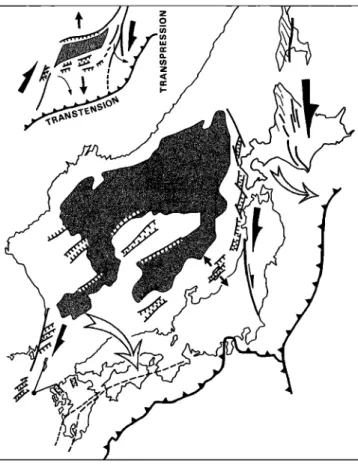
Fig. 6. Simplified opening model with right-lateral pull-apart and dextral rotations in the transtensional domain and sinistral
rotations in the transpressional one. Large solid arrows: motion on the major shear zones; divergent arrows: direction of extension; curved arrows: component of block rotation.
Experimental Procedure
We used the small-scale modeling technique of a brittle- ductile system described by Faug•re and Brun [1984], and Vendeville et al. [1987]. The two-layer models are made of Fontainebleau sand representing the upper brittle crust and silicone (Rhodorsil Rhone Poulenc) representing the lower ductile crust. The layers are added to a rectangular container, the
base of which is made of a fixed plate and a mobile one (Figure 7). The mobile plate, which is displaced at a constant velocity,
has a "dog leg" shaped boundary, which applies pure strike- slip and transtensional displacements to the base of the
silicone. strike -slip boundary velocity discontinuity / basal .... mobile plate
transtensional
boundary
'•'--. free boundary
..,of the sand layer-•-
50cm •...-
sand
Fig. 7. Schematic description of the small-scale experiments
(1 shows velocity discontinuity).
Models are scaled to fit the shear strength profile of the continental crust [Goetze and Evans, 1979]. The sand yields by a Mohr-Coulomb criterion with an internal frictional angle of
30 ø, which may satisfactorily model the frictional behavior of
the upper crust [Byerle,, 1978]. The silicone putty has a
viscosity
of 104 Pa.s at room temperature.
Its shear
strength
depends on displacement velocities. In the experimentspresented here, sand and silicone layers have a thickness of 1
cm. For such a model an appropriate shear strength for the silicone layer is obtained for velocities varying between 0.5 and 10 cmfn (i.e., weak and strong viscous coupling).
Before 12 Ma (i.e. before the beginning of the E-W
compression), the Pacific subduction could be considered a
stress-free boundary (totally free of stress or partly extensional if slab-pull is active) during the Japan Sea opening. To test the
consequences of this lateral boundary condition, most of the
models were constructed such that the sand did not reach the
right wall of the container. Free space between the model and
the lateral wall was filled with silicone. The shape of the free boundary is built identical to that of the basal mobile plate to maintain a constant distance between them. During the building of the sand layer, sand loading creates a flow of the material toward the free space. Even a small amplitude flow near the free boundary is sufficient to create grabens (see Figure
10), so that, strictly speaking, the eastern boundary is not free
of stress but subjected to extension.
Twelve experiments with various displacement velocities and with or without a stress-free lateral boundary have been
4376 JOLIVET ET AL.: ARC DEFORMATION AND MARGINAL BASIN OPENING
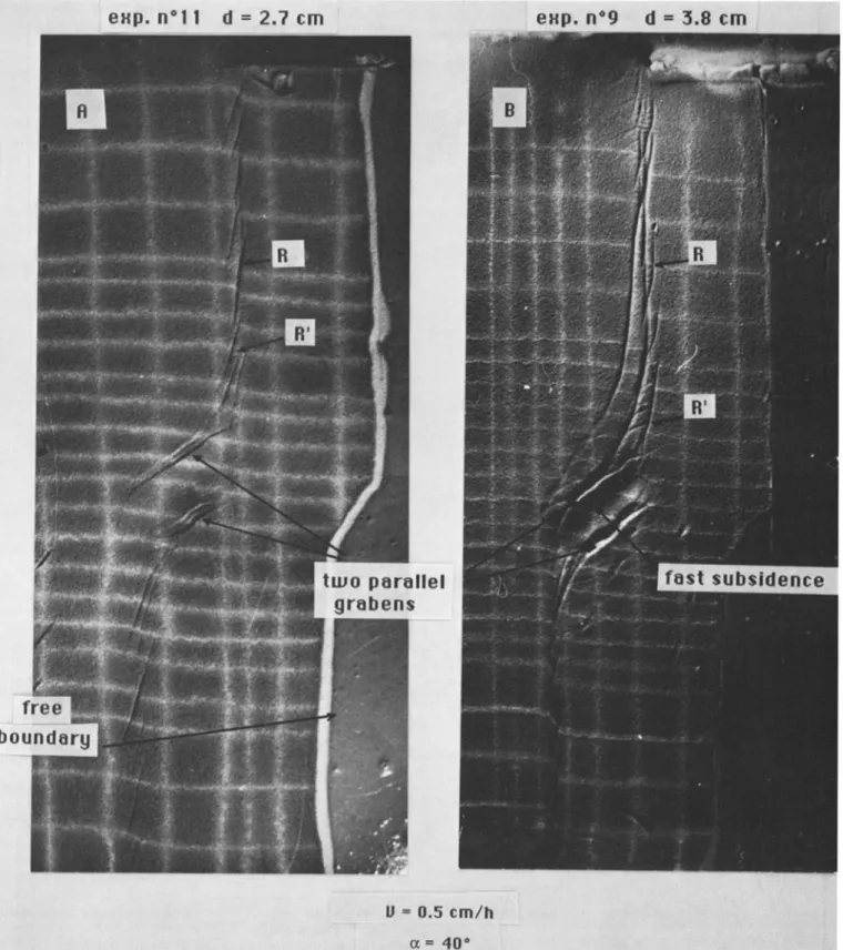
exp n ø'
! 1' d .-.•=
2,7 em
0.5 cm/h
,; .,
•:.:• =: .:40-.o•
fast subsidence :•i
..Fig. 8. Experiments
9 (a) and
11 (b) show
the fault
pattern
with a small
displacement
and
low velocity
(0.5
cm/h)
and
ot = 40
ø. Displacement
are
shown
by the
deformation
of the
whim
grid,
originaly
equally
spaced
(2.5
cm at the center
of the
model
where
most
of the deformation
occurs,
5 cm elsewhere).
At higher
velocities
the
fault pattern
is similar
at the beginning
of the displacement.
Note the R and R' Riedel shears
and the two
parallel
grabens
in the transtensional
area
which
define
a quickly
subsiding
and
rotating
block.
JOLIVET ET AL.: ARC DEFORMATION AND MARGINAL BASIN OPENING 4377
report will be published later. In the following we describe the
general characteristics, similarities and differences of the experiments.
Fault Pattern
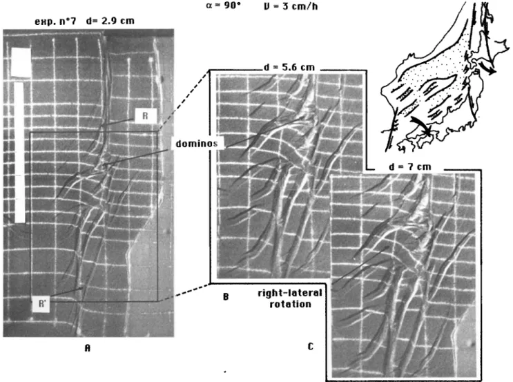
The fault pattern which develops at the onset of deformation combines strike-slip faults above the basal strike-slip boundaries and oblique normal faults above the transtensional boundary. This is well shown by experiments 9 and 11 in Figure 8 with an angle of 40 ø, displacement velocities of 0.5 cm/h, and bulk displacements of 3.8 and 2.7 cm. The transtensional domain is characterized by a large amplitude depression bounded by two parallel grabans. The set of strike- slip faults exhibits well-developed en 6chelon shear, slightly oblique to the main fault direction (R type Riedel shear). In the proximity of the transtensional area the faults curve and antithetic R' type Riedel shears develop. This defines domino- type systems. This general pattern is similar to the one obtained in Mandl's [1987] experiments. At the junction of the transtensional and strike-slip domains the Riedel shears tend to connect with the grabans.
The angle of grabaris on the strike-slip boundary increases with o[ (see Figure 9a where o[ = 90ø). Note also that in this case Riedel shears pass progressively to grabens toward the
transtensional area.
Block Rotations
In the central area, blocks bounded by grabens undergo a rigid dextral rotation during the displacement (Figure 8a). As the displacement increases, the distance between Riedel shears connected to the grabens at the termination of the central area increases. R' type Riedel shears develop creating a system of rotating dominos (Figure 8b). This set of experiments demonstrates that block rotations are enhanced by the existence of a free lateral boundary.
Figure 9 illustrates the progressive rotation of the central block for displacements up to 7 cm. The bulk pattern may be compared with the Japan Sea structure where roughly N-S trending strike-slip faults are connected with NE-SW trending grabens. The central block can be compared with the Yamato bank which separates the two main basins (Japan and Yamato Basins) and suffered a strong subsidence and clockwise rotation (see below) during the opening. We show in a later section that geometrical considerations require a clockwise rotation of the Yamato Bank during the opening. In any case, the rotation must have occurred before 14 Ma [Sayanagi et al., 1987]. The 30 ø of dextral rotation of SW Japan also fits this model well.
Note that the amount of block rotation in the transtensional
domain increases with o•.
Figure 10 illustrates the development of a domino system (also active in Figure 9, but less clear). From the beginning of
exp,
nø7
d
=2,9cm c•=90
ø V=3cm/h
.' .
...
.
...
d 56cm
':? ::•"':.,7-:"::; t::•.:-.:" . .... '" .::.:" :.::.7F:F?•.,:..•?:.::::•L..:.:•.;,5:.::/:•::• • ,• _
:
.:•:
:-.--.
...
%.•:.
•
... •:::•'"';•:'•'•
•..-
rotation •:•..::..::....
Fig. 9. (a) Experiment 7 with o[ = 90 ø, and velocity = 3 cm/h. Center of the model after (b) 5.6 and (c) 7 cm of displacement. Note the domino system and the clockwise rotation of the central block. A simplified sketch of
4378 JOLIVET ET AL.: ARC DEFORMATION AND MARGINAL BASIN OPENING
'c• = 35 'o V :,= 3 cm/h
exp nø3 d = 2..7 cm.:
d.ominos with
ri. ght--:l:at.e'[al rot. al. io:n
Fig. 10. Experiment 3 with oc = 35 ø and velocity = 3 cm/h. It shows very clearly the development of the domino system. Note that the rotation of dominos is accomodated by letft-lateral motion along R' shears and that during the rotation the width of the domino system increases. Note also the grabens which develop along
the free boundary. Displacement (a) 2.7 cm, (b) 5.3 cm, (c) 7.5 cm is shown.
the deformation, R Riedel shears of the strike-slip domain pass
to oblique normal faults in the transtensional domain (Figure 10a). As the displacement increases, they separate and R' left- lateral shears develop between them (Figures 10a and 10b). Subsequent deformation rotates the fault-bounded blocks like dominos. Figures 10b and 10c show that block rotation
decreases and disappears where R' shears are not present. A direct comparison beween these models and the Japan area suggests the occurrence of dextral rotating domino systems
along the eastern margin of the Japan Sea. The "en 6chelon" grabens which exist in this region could be interpreted in this
way.
This deformation pattern with rotation of dominos has been studied by Nut et al. [1986] and Mandl [1987]. Martell et
a/.[1988] and Ron et al. [1984] described field examples of such structures. Martell et al. [1988] explained that the
rotation sense of blocks bounded by cross faults between two
sinistral boundary faults is determined by the component of
movement across these boundary faults: if an extensional component is present the sense of rotation is counterclockwise, if a component of compression is instead present the sense of rotation is clockwise. In Nur et al. [1986] the authors concluded to a rotation in the opposite sense but predetermined the crossfaults in a position which does not correspond to what we observe here. In our experiments the
distance between the two boundary faults increases during the rotation. This is allowed by the extensional component introduced by the free boundary.
Although the comparison of the models with the opening of the Japan Sea (Figure 9, insert) is interesting, the 20 ø of sinistral rotation in northern Japan deduced from paleomagnetic data and also from our reconstructions (see below) still has to be explained. One solution is that the
reverse sense of rotation here is xelated to the dextral
transpressive motion which characterized the northern part of
the basin.
RECONSTRUCTIONS
The reconstructions are made using constraints from the structural and paleomagnetic data and the asymmetric pull-apart mechanism (with a "free boundary") just discussed. The rotations of the different blocks and the right-lateral displacements are constrained by the present structure of the
basin.
Figure 11 shows the right-lateral transfer faults between the en 6chelon graberis along the eastern margin of the Japan Sea. The strikes of these faults progressively change from NW-SE in the north to N-S in the south. Figures 11 and 12a show that these trends fit small circles about a pole located at 35.8øN and
JOLIVET ET AL.: ARC DEFORMATION AND MARGINAL BASIN OPENING 4379 138 o 1400 142 o 460 440 420 400 380 360
Fig. 11. The transfer faults recognized in Figure 3 and 5 (thick
lines) fit small circles about a pole located at 35.8øN and
122øE.
is distributed over the whole width of the dextral shear zone
with a single rotation pole.
We reconstruct the position of the Yamato Bank before the opening taking into account the shape similarity between its northern margin and the corresponding area of the Eurasian maxgin. A fit of these two features gives a pole located at 34øN and 129øE which is very close to the pole of the rotation of SW Japan proposed by Otofuji and Matsuda [1983].
To accommodate the deformation observed along the
Hokkaido Central Belt, one must consider a certain mount of
shortening during the strike-slip movement. Given the direction of the belt, one needs a pole that makes the Okhotsk block move along a roughly north-south direction. Thus the
pole is rather remote. We finally end with three different rotation poles to move the various blocks. The more external the block the more remote the pole. The rotation pole of the
block located between the two master strike-slip faults
(southwestern Japan) is closer than than the pole of the outside
block (northeastern Japan). The crustal structure recognized by
Tamak/ [1986] (Figure 2] in the Japan Sea constrains the total amount of rotation we can use. Figures 12b and 12c show two reconstructions. Figure 12b corresponds to the hypothesis of a single stage opening. The analog experiments show that the simultaneous opening of two depressions (Japan basin and Yamato Basin) with a rotating unstrained block between (Yamato bank) is possible. Figure 12c is a possible preopening reconstruction. The total clockwise rotation of SW Japan is 20 ø. The total counterclockwise rotation of NE Japan
is also 20 ø .
The history of the opening can be summarized as follows (Figure 12d) from Late Oligocene to Middle Miocene (further data axe needed to constrain more precisely the timing): a right- lateral shear was distributed over the whole Japan Arc and Sakhalin region with a transtensional context in the south and a transpressional one in the north. This led to the formation of NE-SW pull-apart basins in the Japan Sea region. The two main grabens evolved and became oceanic basins giving birth to the Yamato and Japan Basins. Within this wide dextral shear zone, tectonic blocks rotated about vertical axes during the basins opening. During this process all the earlier major Mesozoic faults were reactivated. The strike-slip motion stopped about 12 Ma ago and was replaced by an E-W shortening which is now localized along the eastern margin as an active zone of underthrusting.
CONCLUSION
We model the Japan Sea opening as a distributed dextral
shear over a width of about 500 km from E to W. The
deformation proceeds along two N-S trending boundary shear
zones with rotations of blocks between them. The finite
displacement of the eastern margin relative to the western one is comparable to the overall size of the basin (500 km).
The deformation of the island arc has been complex. The
marginal basin opened in a dextral shear context with a
component of extension along the Pacific margin. Only the
northern part of the system (Hokkaido Central Belt and
Sakhalin) has been subjected to a transpressive stress field
leading to counterclockwise rotations there. The
reconstructions shown here are described in terms of rigid blocks rotations although a more complex model with
distributed deformation is more likely.
Distributed deformation across the 80-km-wide area along the New Zealand Alpine fault has been demonstrated by
Walcott [1984;,1987], Jackson [1987], Lamb [1988] on the
basis of a geodetic and paleomagnetic survey. Hamburger and Isacks [1988] have intepreted the opening of the North Fiji basin as a mega pull-apart along the Pacific-Australia plate
boundary. West of the Japan Sea, the Bohai intracontinental basin also opened in a dextral shear zone [Nabelek et al., 1987;
Chen and Nabelek, 1988]. The opening of such basins can no longer be considered to be only caused by trench retreat which
may provide the overall transtensional stress field but not the strike-slip component. The continental collision of India and
Asia is the most likely candidate as a driving phenomenon for
these major N-S dextral faults. Tapponnier et al .[1982, 1986]
emphasized the role played by left-lateral motion along the Red River Fault in the South China Sea opening in the Late Tertiary. Kimura and Tamaki [1986] first proposed that the right-lateral pull-apart opening of the Japan Sea is a
©B 130 ø I
I
I
I
140 ø 40 ø 40 ø 130 ø 140 øFig. 12. Kinematic model and reeonsla'uctions of the Japan Sea opening. (a) Present stage and the small circles about the poles used in the reconstructions (A: 34øN, 129øE, which is used for the rotation of SW Japan and the Yamam Bank inside the pull apart system, B: 35.8, 122øE, used for the southward drift due to the right-lateral pull-apart). (b) Reconstruction during the opening assuming that the Japan basin and Yamam Basins opened almost synchroneously. The arrows represent the displacement vectors necessary to reach the present day position, the dashed curves stand for small circles. Key shows (1) oceanic crust, (2) thinned continental crust, (3) small circles, (4) main strike-slip faults, (5) spreading centers. (c) Possible configuration at the beginning of the opening according to our model. (d) Synthetic figure showing the north-south translation and progressive bending of the are. Dark shading represents the present-day situation, light shading is the pre- opening situation, and the intermediate shading represents a stage during the opening, possibly around 20 Ma.
JOI.IVE-T ET AL.: ARC DEFORMATION AND MARGINAL BASIN OPENING 4381
Fig. 12. (continued)
experiments of continental collision by Cobbold and Davy [1988] and Davy and Cobbold [1988], we proposed [Jolivet et al., 1990] that the right-lateral faults in the Japan Sea and Bohai Gulf regions are N-S trending conjugates of the major NE-SW trending left-lateral faults which guide the motion of continental blocks eastward. This is, however, possible, only if the Pacific subduciton provides the low stress condition along the eastern boundary of the deforming system. The description of the geometry and mechanics of the opening made in the present paper will be used in our future works to
understand the respective parts played by the Pacific
subduction and the extrusion tectonics in terms of kinematics
and, if possible, of forces. One important question is, for instance, the reason of the drastic change from extension to compression in Late Miocene and the resulting inception of a new subduction zone along the eastern margin of the Japan Sea in the Quaternary [Nakamura, 1983; Tamaki, 1988].
Acknowledgments. The authors are indebted to their colleagues in Japan, particularly K. Tamaki for fruitful
4382 JOLIVET ET AL.: ARC DEFORMATION AND MARGINAL BASIN OPENING
discussion. K. Otsuki and T. Ohguchi and S. Miyashita and all
the members
of the Hokkaido
Tectonics
Research
group
were
Of
considerable help for the survey in northern Honshu andHokkaido. Thanks are due to R. McCabe and the second
anonymous reviewer, as well as to R. Davies for useful comments and improvement of the English. Part of this work
was f'manced by the French Ministry of Foreign Affairs.
REFERENCES
Angelier, J., Tectonic analysis of faultslip data sets, J. Geophys. Res., 89, 5835-5848, 1984.
Antipov, M.P., Kovylin, V. M. and V. P. Filat'yev, Sedimentary cover of the deep water basins of Tatar strait and the northern part of the sea of Japan. lnt. Geol. Rev.,
22, 1327-1334, 1980.
Byerlee, J. D., Friction of rocks, Pure Appl. Geophys., 116,
615-626, 1978.
CCOP-IOC, Southwest Japan, Korea peninsula, International decade of ocean exploration ]IDOE) and studies in eastasian tectonics and resources (SEATAR), U. N. ESCAP, CCOP,
Tech. Bull., 123-137, 1980.
Celaya, M. and R. McCabe, Kinematic model for the opening of the Sea of Japan and the bending of the Japanese islands, Geology, 15, 53-57, 1987.
Chase, C. G., Extension behind island arcs and motion relative to hot-spots, J. Geophys. Res., 83, 5385-5387, 1978. Chen, W. P. and J. Nabelek, Seismogenic strike-slip faulting
and the development of the North China basin, Tectonics, 7,
975-989, 1988.
Cobbold, P. R. and P. Davy, Indentation tectonics in nature and experiments, 2, Central Asia, Bull. Geol. lnst. Upsalla, 14, 143-162, 1988.
Davy, P. and P. R. Cobbold. Indentation tectonics in nature and experiments. Experiments scaled for gravity,Bull. Geol. Inst. Upsalla, 14, 129-141, 1988.
Fabbri, O., J. Charvet, and M. Faure, Sur la d6formation
associ6e •t la rotation de Kyushu (Japon SW) au Miocene Moyen, C. R. Acad Sci. Paris, 304, 1207-1212, 1987. Faug•re, E. and J.P. Brun, Mod•lisation exp6rimentale de la
distension continentale, C. R. Acad. Sci. Paris, 299, 365- 370, 1984.
Faure, M. and F. Lalev•e Bent structural trends of Japan, flexural slip folding related to the Neogene opening of the sea of Japan, Geology, 15, 49-52, 1987.
Fukao, Y. and M. Furumoto, Mechanisms of large earthquakes along the eastern margin of the Japan sea, Tectonophysics, 25, 247-266, 1975.
Ganzawa, Y., "Green Tuffs" movement defined by fission-track ages of igneous rocks, 1, Sado Island, J. Geol. Soc. Jpn.,
88, 943-956, 1982.
Ganzawa, Y., "Green Tuffs" movement defined by fission-track ages of igneous rocks, 2, Futimoyama area of Toyama prefecture, central Japan, J. Geol. Soc. Jpn.., 89, 271-286,
1983.
Ganzawa, Y., Fission tracks age of volcanic rocks from Cretaceous to Tertiary in the inner belt of northeast Japan, Okushiri island, Oga peninsula and Asahi mountains, J. Geol. Soc. Jpn., 93, 387-401, 1987.
Goetze, C. and B. Evans, Stress and temperature in the bending lithophere as constrained by experimental rocks mechanics, Geophys. J.R. Astron. Soc., 59, 463-478, 1979.
Hamburger, M.W. and B. L. Isacks, Diffuse back-arc deformation in the southwestern Pacific, Nature, 332,599-
604, 1988.
Harding, T. P., Seismic characteristics and identification of negative flower structures, positive flower structures and positive structural inversions, Am. Ass. Petr. Geol. Bull.,
69, 582-600, 1985.
Hayashida, A., Timing of rotationhal motion of Southwest
Japan inferred from palcomagnetism of the Setouchi Miocene series, J. Geomagn. Geoelectr., 38, 295-310,
1986.
Hilde, T. W. C., S. Uyeda, and L. Kroenke, Evolution of the western Pacific and its margins, Tectonophysics, 38, 145-
165, 1977.
Hilde, T. W. C and J. M. Wageman, Structure and origin of the
Japan sea, in, The Western Pacific, Island Arcs, Marginal
Seas, Geochemistry, edited by P. J. Coleman, University of Western Australia Press, Perth, pp. 123-137, 1975.
Hirooka, K., H. Sakai, T. Takahashi, H. Kinoto, and A. Takeuchi, Tertiary tectonic movement of central Japan inferred from palcomagnetic studies, J. Geomagn. Geoelectr., 38, 311-323, 1986.
Honza, E. (Ed.), Geological investigation of the Japan sea,
April-June 1978 (GH-78-2 cruise), Geol. Surv. Jpn, Cruise R ep.. 13, 99 pp., Geological Survey of Japan, Tsukuba,
1979.
Hornafius , J. S., B. P. Luyendik, R. R. Terres, and M.J. Kamerling, Timing and extent of Neogene tectonic rotation in the Western Transverse Ranges, California, Geol. Soc. Am. Bull., 97, 1476-1487, 1986.
Ichikawa, K., Geohistory of the Median Tectonic Line of Southwest Japan, Mere. Geol. Soc. Jpn, 18, 187-212,
1980.
Iijima, A., R. Tada, and Y. Watanabe, Development of Neogene
sedimentary basins in the northeastern Honshu arc with emphasis on Miocene siliceous deposits, J. Fac. Sci. Univ. Tokyo, 21, 417-446, 1988.
Ingle, J.C., Summary of Late Paleogene Neogene insular stratigraphy, and correlations, Philippine Sea and sea of Japan region, in Initial Report of DSDP, vol. 31, US Government Printing Office, pp. 837-855, Washington
D.C., 1975.
Isezaki, N., A magnetic anomaly map of the Japan sea, J. Geomagn. Geoelectr., 38, 403-410, 1986.
Isezaki, N. and S. Uyeda, S., Geomagnetic anomaly pattern of the Japan sea, Mar. Geophys. Res., 2, 51-59, 1973. Ishikawa, N., and M. Torii, Counterclockwize rotations of the
Tsushima and Goto islands, Southwest margin of the Japan Sea, evidences from palcomagnetism, paper presented at 1988 DELP Tokyo International Symposium, Tokyo Intsitute of Technology, Tokyo, Dec. 13-16, 1988.
Ishizuka, H., Greenstones from the Idonnappu formation along the river Oku-Niikappu in the axial zone of Hokkaido,
Japan, Mere. Fac. Sci., Kochi Univ., 2, 1-22, 1981.
Ishizuka H., M. Imaizumi, N. Gouchi, and S. Banno, The Kamuikotan zone in Hokkaido, Japan, tectonic mixing of
high pressure and low pressure metamorphic rocks, J.
Metamorph. Geol., 1, 263-265, 1983.
Itoh, Y., Differential rotation of norteastern part of southwest
Japan, palcomagnetism of Early to Late Miocene rocks from
Yatsuo area in Chubu district, J. Geomagn. Geoelectr., 38,
325-334, 1986.
Itoh, Y., Differential rotation of the eastern part of southwest Japan inferred from palcomagnetism of Cretaceous and Neogene rocks, J. Geophys. Res., 93, 3401-3411, 1988. Itoh, Y., and H. Ito, Tertiary rotational movement of the
eastern part of southwest Japan, palcomagnetism and fission-track dating of the Futomiyama Group in the Uozu
area, Toyama prefecture, Japan, J. Geol. Soc. Jpn., 94, 11-
18, 1988.
Jackson, J.A., Active continental deformation and regional
metamorphism, Philos. Trans. R. Soc. London., 321, 47-
66, 1987.
Jolivet, L., The Hokkaido Central Belt, the succession of
tectonic stages, Bull. Soc. Gdol. France, 2, 311-327., 1986a.
![Fig. 3. Bathymetric map of the eastern margin of the Japan Sea after [Maritime Safety Agency of Japan, 1980a, b) and the main onland tertiary structures [after Jolivet and Huchon, 1989; Yamaft, 1989]](https://thumb-eu.123doks.com/thumbv2/123doknet/14759510.584294/6.876.156.707.63.1022/bathymetric-eastern-maritime-safety-agency-tertiary-structures-jolivet.webp)