HAL Id: hal-00297373
https://hal.archives-ouvertes.fr/hal-00297373
Submitted on 23 Jan 2006
HAL is a multi-disciplinary open access
archive for the deposit and dissemination of
sci-entific research documents, whether they are
pub-lished or not. The documents may come from
teaching and research institutions in France or
abroad, or from public or private research centers.
L’archive ouverte pluridisciplinaire HAL, est
destinée au dépôt et à la diffusion de documents
scientifiques de niveau recherche, publiés ou non,
émanant des établissements d’enseignement et de
recherche français ou étrangers, des laboratoires
publics ou privés.
The 11?12 December 2003 storm in Southern Italy
S. Federico, C. Bellecci
To cite this version:
S. Federico, C. Bellecci. The 11?12 December 2003 storm in Southern Italy. Advances in Geosciences,
European Geosciences Union, 2006, 7, pp.37-44. �hal-00297373�
Advances in Geosciences, 7, 37–44, 2006 SRef-ID: 1680-7359/adgeo/2006-7-37 European Geosciences Union
© 2006 Author(s). This work is licensed under a Creative Commons License.
Advances in
Geosciences
The 11–12 December 2003 storm in Southern Italy
S. Federico1,2and C. Bellecci1,3
1CRATI Scrl, c/o University of Calabria, 87036 Rende (CS), Italy 2CNR-ISAC, via del Fosso del Calvaliere, 100, 00133 Rome, Italy 3Facolt`a di Ingegneria, Universit`a di “Tor Vergata”, Rome, Italy
Received: 7 October 2005 – Revised: 22 December 2005 – Accepted: 28 December 2005 – Published: 23 January 2006
Abstract. We review an intense and heavy impact storm that occurred over Calabria, southern Italy, during the 11 and 12 December 2003. The event is traced back, at synoptic and planetary scales, up to 5 December 2003 by National Cen-tre for Environmental Prediction/National CenCen-tre for Atmo-spheric Research (NCEP/NCAR) reanalysis fields and back-trajectories.
The role of tropical storm Odette is clearly shown as well as that of the Azores high. Even if non negligible water vapour sources are expected from the Mediterranean sea, un-usually large precipitable water was present over the Atlantic mid-latitudes. It is shown that tropical storm Odette deter-mined large evaporation from Atlantic Tropics and the coop-erative action of synoptic scale and planetary scale pressure centres focused this humidity into a plume and conveyed it into the Mediterranean area.
1 Introduction
The Mediterranean region is often characterized by torrential rainfall and flash floods at different spatial and time scales (Siccardi, 1996) and several cases have been studied, dis-cussed and reported in different countries around the basin.
Unusually intense rainfall occurred on 11–12 December 2003 over Calabria, southern Italy. Calabria climate is rather dry, yet heavy and high impact rainfall are not uncommon (Reale et al., 2001; Federico et al., 2003a, b).
Figure 1 shows Calabria topography averaged over 10 km2 and a subset of raingauges used to analyze precipitation. Figure 2 reports analyzed precipitation cumulated from 23:00 UTC – 10 December 2003 to 23:00 UTC – 12 Decem-ber 2003. More than 250 mm were recorded over a vast area in southern Calabria and one station reported about 660 mm in two days (more than half of the yearly total amount). Ac-cumulated rain is greater over main peaks (mainly over Sila, Serre and Aspromonte) due to the orographic uplift and there Correspondence to: S. Federico
(s.federico@crati.it)
is a partial shielding effect of mountain ranges that leaves more precipitation over Ionian coastal areas. Precipitation fell mainly during 12 December when the storm was more active over southern Calabria. Landfalls were reported in several villages and damages to properties was extensive.
2 Role of the tropical cyclone Odette
The following synoptic analysis is based on data from NCEP/NCAR reanalysis project (Kalnay et al., 1996; Kistler et al., 2001). Data are produced with a data assimilation sys-tem with a T62/28L space resolution global spectrum model and are available on a 2.5◦×2.5◦ longitude-latitude regular
grid.
In this section, synoptic conditions are traced back to 5 December to highlight the role of a tropical storm, named Odette, respect to heavy precipitation recorded in Calabria a week later.
Reanalysis can provide broad information, due to their coarse horizontal resolution, of the tropical storm and fol-lowing development of synoptic patterns.
Odette detailed description can be found in Franklin (2003). It was a rare December tropical storm that made landfall in the Dominican Republic and it was the first De-cember tropical storm on record to form in the Caribbean sea.
Figure 3 shows the best track for this tropical storm. Fig-ures 4a, b and c show, respectively, the sea level pressure, precipitable water and 850 hPa wind fields for 5, 6, 7 De-cember 2003 over the Atlantic. The injection of huge hu-midity amounts into the atmosphere can be easily explained by Odette. The strong winds and convergence in the tropi-cal storm is the responsible of large precipitable water over the Caribbean on 5 and 6 December (Figs. 4a and b). This humid air is then reorganized by a developing cyclone off the US East coasts (Fig. 4c) and then transported toward the Mediterranean basin through the cooperative action of sev-eral centres, as discussed in the next two sections.
38 S. Federico and C. Bellecci: The 11–12 December 2003 storm in Southern Italy
Fig. 1. Topography of Calabria averaged over 10 km2. Main features are also reported. Contours: 100 m, 500 m, 1000 m and 1400 m. Dots show raingauges locations.
Fig. 2. Analyzed rainfall from 23:00 UTC – 10 December 2003 to 23:00 UTC – 12 December 2003. In the objective Cressman analy-sis we use a search radius of 0.15◦. More that 130 raingauges were available for the analysis.
3 Role of the Atlantic anticyclone
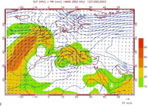
Figures 4d–f show the Atlantic sea level pressure, precip-itable water and 850 hPa wind field for 8 December 2003 – 12:00 UTC, 9 December 2003 – 12:00 UTC and 10 Decem-ber – 00:00 UTC, respectively.
Fig. 3. Tropical storm Odette best track (from Franklin 2003).
Figure 4d shows two humid plumes extending from trop-ical Atlantic to mid-latitudes. The westernmost one is asso-ciated with tropical storm Odette. A deep cyclone is active off the US East coast and the Azores high is well expanded over the Atlantic Ocean. This peculiar baric situation focuses large precipitable water amounts into a plume and clearly demonstrates that the origin of the water vapour is, at least partially, from tropical Atlantic.
The process is still active 24 h later, as shown in Fig. 4e. The deep cyclone moved toward North-East and Azores high retracted. At the same time, a low pressure pattern with a central minimum of 1000 hPa moved from Iceland toward Iberia peninsula. This cyclone is the one that determined the 11th–12th event over Calabria. The Azores high acquired a circular shape and, by cooperative action with other pres-sure centres, conveys high precipitable water amounts into the Mediterranean area.
The process is still active on 00:00 UTC 10 December, as shown in Fig. 4f. At this time the Azores high retreated and moved toward North-East. The cyclone responsible of heavy precipitation over Calabria is now into the Mediter-ranean basin. Eighteen hours later the Azores high expanded (not shown). This shift creates the circulation conditions for interruption of air masses transport from tropical Atlantic to Mediterranean and Europe.
According to the previous analysis, planetary and synop-tic scales acted together to determine the intense and heavy impact processes involved with this event.
4 Synoptic scale analysis
Figures 4g–j show sea level pressure, 850 hPa wind field and precipitable water from 9 to 12 December 2003 – 12:00 UTC. On 9 December, the storm that produced heavy rainfall over Calabria is positioned to the West of the Iberian penin-sula. This shows its Atlantic origin. Precipitable water is greater than 30 g/kg over the Atlantic and it is associated with
S. Federico and C. Bellecci: The 11–12 December 2003 storm in Southern Italy 39
(a)
(b)
40 S. Federico and C. Bellecci: The 11–12 December 2003 storm in Southern Italy
(d)
(e)
S. Federico and C. Bellecci: The 11–12 December 2003 storm in Southern Italy 41
(g)
(h)
42 S. Federico and C. Bellecci: The 11–12 December 2003 storm in Southern Italy
(j)
Fig. 4. (a): Sea level pressure (solid contours), 850 hPa wind field and total precipitable water (shaded contours) for 12:00 UTC – 5 December 2003. (b) As in (a) for 6 December 2003 – 12:00 UTC. (c) As in (a) for 7 December 2003 – 12:00 UTC. (d) As in (a) for 8 December 2003 – 12:00 UTC. (e) As in (a) for 9 December 2003 – 12:00 UTC. (f) As in (a) for 10 December 2003 – 00:00 UTC. (g) As in (a) for 12:00 UTC - 9 December 2003 and for the Mediterranean. (h) As in (g) for 10 December 2003 – 12:00 UTC. (i) As in figure (g) for 12:00 UTC – 11 December 2003. (j) As in figure (g) for 12:00 UTC – 12 December 2003.
planetary scale and synoptic scale action centres discussed in Sects. 2–3. In particular, two humid filaments of high precip-itable water are evident in Fig. 4g over eastern Atlantic. First one is oriented from N-W to S-E and entered the Mediter-ranean basin; the second plume, located at about 30◦W– 20◦N on 9 December – 12:00 UTC, did not play a major role during the storm and is associated with tropical storm Peter. After 24 h, Fig. 4h, the low pressure centre is over Algeria and its action is twofold. First winds over Southern Italy in-crease, second the plume of large water vapour of Atlantic origin is transported into the Mediterranean basin. Sustained winds over the southern Mediterranean area increase latent heat fluxes and add humidity to the overlaying air (Figs. 4i– j).
As a consequence of the storm evolution, winds cross Cal-abria from S-SE and air masses are rather humid. The pe-culiar shape of calabrian orography together with previous discussed synoptic scale processes and in particular the la-tent heat fluxes from the Mediterranean sea determined the heavy rainfall recorded during the event.
Moreover, even if we do not discuss the mesoscale of the storm in this paper, Fig. 2 shows the importance of mesoscale processes as orographic uplift operating within the favourable synoptic scale environment.
5 Trajectory analysis
In this section we adopt a trajectory analysis to better iden-tify the storm air masses origin. This approach was
al-ready applied in Krichak and Alpert (1998, 2004), Stohl and James (2004), Turato et al. (2004) to determine the origin of air moisture in high impact cyclones over Europe and the Mediterranean region.
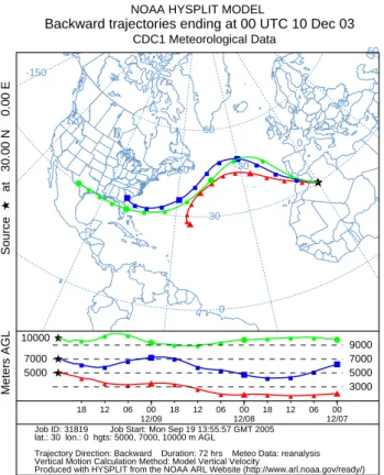
The advanced Hybrid Single Particle Integrated Trajec-tory system (HYSPLIT), of the NOAA/ARL, is applied for a three dimensional trajectory calculation (Draxler and Rolph, 2003). The model uses gridded meteorological data from the reanalysis project. Figure 5a shows backward trajecto-ries for air masses ending at 40◦N–15◦E on 12 December 2003 – 00:00 UTC. Air masses started at 5000 m, 7000 m and 10 000 m above ground level and are representative of air movements at mid and upper troposphere. Figure 5b shows the same integrations for parcels ending at 0◦E–30◦N on 10 December 2003 – 00:00 UTC. These positions were chosen because they are representative of the air masses that reached Calabria during the storm most intense phase and the inte-gration is divided in two parts to better appreciate air move-ments over the Atlantic and over the Mediterranean. More-over, a rough estimate of precipitable water and sea surface pressure can be achieved comparing figures 4 and 5 and con-sidering that marks are reported in Fig. 5 every six hours. From Figs. 5a and b it follows that air masses crossed the Atlantic Ocean during 7–10 December, then entered in the Mediterranean area and went over Calabria, transported by the synoptic scale processes discussed in the previous sec-tion.
S. Federico and C. Bellecci: The 11–12 December 2003 storm in Southern Italy 43 -150 -120 -90 -60 -30 0 30 60 0 30 60 ★ ▲ ▲ ▲ ▲ ▲ ▲ ▲ ▲ ▲ ▲ ▲▲ ★ ■ ■ ■ ■ ■ ■ ■ ■ ■ ■ ■ ■ ★ ● ● ● ● ● ● ● ● ● ● ● ● ★ ▲ ▲ ▲ ▲ ▲ ▲ ▲ ▲ ▲ ▲ ▲ ▲ ★ ■ ■ ■ ■ ■ ■ ■ ■ ■ ■ ■ ■ ★ ● ● ● ● ● ● ● ● ● ● ● ● 3000 5000 7000 9000 5000 7000 10000 18 12 06 00 12/09 18 12 06 00 12/08 18 12 06 00 12/07
NOAA HYSPLIT MODEL
Backward trajectories ending at 00 UTC 10 Dec 03 CDC1 Meteorological Data
Source
★
at 30.00 N 0.00 E
Meters AGL
Job ID: 31819 Job Start: Mon Sep 19 13:55:57 GMT 2005 lat.: 30 lon.: 0 hgts: 5000, 7000, 10000 m AGL
Trajectory Direction: Backward Duration: 72 hrs Meteo Data: reanalysis Vertical Motion Calculation Method: Model Vertical Velocity Produced with HYSPLIT from the NOAA ARL Website (http://www.arl.noaa.gov/ready/)
Fig. 5a. HYSPLIT back-trajectories ending at 0◦E–30◦N on 10 December 2003 – 00:00 UTC.
6 Conclusions
We revisit the 11–12 December 2003 storm that produced extended damages in Calabria, southern Italy, at synoptic and planetary scales using NCEP/NCAR reanalysis data and backtrajectories. Even if local scale and mesoscale processes were certainly important during the storm, our attention is focused on the large amount of precipitable water available over Atlantic mid-latitudes.
We traced back the storm up to 5 December 2003 and demonstrated that tropical storm Odette, active from 4 to 7 December 2003 in the Caribbean, injected large amount of water vapour into the atmosphere. This humidity was then reorganized and focused by the cooperative action of the a) Azores high; b) a deep cyclone developed off the US Atlantic coast; c) the cyclone that determined heavy precipitation over Calabria.
These findings have important implications for severe weather forecast over Central Mediterranean area. First, the tropical storm activity over Atlantic should be carefully mon-itored in order to detect potential risk situations. Second, model domains should consider in their integration area a larger portion of Atlantic Ocean than the one used nowadays. Third, more cases study must be investigated to confirm re-sults discussed above and to better focus on key factors that could be used as precursor of severe storms.
−30 −15 0 15 30 15 30 45 ★ ▲ ▲ ▲ ▲ ▲ ▲ ▲ ▲ ▲ ▲ ▲ ▲ ★ ■ ■ ■ ■ ■ ■ ■ ■ ■ ■ ■ ■ ★ ● ● ● ● ● ● ● ● ● ● ● ● ★ ▲ ▲ ▲ ▲ ▲ ▲ ▲ ▲ ▲ ▲ ▲ ▲ ★ ■ ■ ■ ■ ■ ■ ■ ■ ■ ■ ■ ■ ★ ● ● ● ● ● ● ● ● ● ● ● ● 3000 4500 6000 7500 5000 7000 10000 18 12 06 00 12/11 18 12 06 00 12/10 18 12 06 00 12/09
NOAA HYSPLIT MODEL
Backward trajectories ending at 00 UTC 12 Dec 03
CDC1 Meteorological Data
Source
★
at 40.00 N 15.00 E
Meters AGL
Job ID: 31246 Job Start: Mon Sep 19 13:30:44 GMT 2005 lat.: 40 lon.: 15 hgts: 5000, 7000, 10000 m AGL
Trajectory Direction: Backward Duration: 72 hrs Meteo Data: reanalysis Vertical Motion Calculation Method: Model Vertical Velocity
Produced with HYSPLIT from the NOAA ARL Website (http://www.arl.noaa.gov/ready/)
Fig. 5b. As in Fig. 5a for trajectories ending at 15◦E–40◦N on 12 December 2003 – 00:00 UTC.
We conclude considering that hurricane activity seems to increase during last decade. For instance, during 2003, hur-ricane season saw the development of 16 named storm, well above the 1944–1996 average of 9.8.
Acknowledgements. This work was realized in the framework of the project “SAI – Messa a punto di un Sistema per l’Allerta precoce di Incendi e per la minimizzazione dei falsi allarmi” funded by “Ministero dell’Universit`a e della Ricera Scientifica”. We acknowledge APAT – Dipartimento Tutela delle Acque Interne e Marine for raingauge data. We are grateful to the Italian Air Force and ECMWF for MARS database account. We acknowledge the NOAA/Air Resource Laboratory (ARL) for provision of the HYSPLIT web site and the NOAA National Hurricane Center (NHC) for kindly providing data on tropical storm Odette and for Fig. 3.
Edited by: V. Kotroni and K. Lagouvardos Reviewed by: anonymous referee
References
Draxler, U. and Rolph, G. D.: NOAA ARL HYSPLIT model. NOAA/Air Resource Laboratory, Silver Spring, MD, available online: http://www.arl.noaa.gov/ready/hysplit4.html, 2003. Federico, S., Bellecci, C., and Colacino, M.: Quantitative
precip-itation of the Soverato flood: the role of orography and surface fluxes, Nuov. Cim. C, 26C, 7–22, 2003a.
44 S. Federico and C. Bellecci: The 11–12 December 2003 storm in Southern Italy Federico, S., Bellecci, C., and Colacino, M.: Numerical simulation
of Crotone flood: storm evolution, Nuov. Cim. C, 26C, 357–371, 2003b.
Franklin, J .L. : Tropical storm Odette, available online: http: //www.nhc.noaa.gov/2003odette.shtml, 2003.
Kalnay, E., Kanamitsu, M., Kistler, R., et al.: The NCEP/NCAR 40-Year Reanalysis Project, Bull. Amer. Meteor. Soc., 77, 437–471, 1996.
Kistler, R., Collins, W., Suranjana, S., et al.: The NCEP/NCAR 50-year reanalysis: Monthly means CD-ROM and documentation, Bull. Amer. Meteor. Soc., 82, 247–268, 2001.
Krichak, S. O. and Alpert, P.: Role of large-scale moist dynamics in the November 1–5, 1994, hazardous Mediterranean weather, J. Geophys. Res., 103 (D16), 19 453–19 468, 1998.
Krichak, S. O., Alpert, P., and Melina, D.: The role of atmospheric processes associated with hurricane Olga in the December 2001 floods in Israel, J. Hydrometeor., 5, 1259–1270, 2004.
Reale, O. and Atlas, R.: Tropical cyclone-like vortices in the ex-tratropics: Observational evidence and synoptic analysis, Wea. Forecasting, 16, 7–34, 2001.
Siccardi, F.: Rainstorm hazards and related disasters in the western Mediterranean region, Remote Sens. Rev., 14, 5–21, 1996. Stohl, A. and James, P.: A Lagrangian analysis of the atmospheric
branch of global water cycle. Part 1: Model description, valida-tion, and demonstration for the August 2001 flooding over Eu-rope, J. Hydrometeor., 5, 656–678, 2004.
Turato, B., Reale, O., and Siccardi, F.:Water vapor sources of the October 2000 Piedmont flood, J. Hydrometeor., 5, 693–712, 2004.