Publisher’s version / Version de l'éditeur: Technical Report, 2013-01-01
READ THESE TERMS AND CONDITIONS CAREFULLY BEFORE USING THIS WEBSITE.
https://nrc-publications.canada.ca/eng/copyright
Vous avez des questions? Nous pouvons vous aider. Pour communiquer directement avec un auteur, consultez la première page de la revue dans laquelle son article a été publié afin de trouver ses coordonnées. Si vous n’arrivez pas à les repérer, communiquez avec nous à [email protected].
Questions? Contact the NRC Publications Archive team at
[email protected]. If you wish to email the authors directly, please see the first page of the publication for their contact information.
NRC Publications Archive
Archives des publications du CNRC
For the publisher’s version, please access the DOI link below./ Pour consulter la version de l’éditeur, utilisez le lien DOI ci-dessous.
https://doi.org/10.4224/21270996
Access and use of this website and the material on it are subject to the Terms and Conditions set forth at
Navigation in Greenland waters
Tivy, Adrienne; Frederking, Robert
https://publications-cnrc.canada.ca/fra/droits
L’accès à ce site Web et l’utilisation de son contenu sont assujettis aux conditions présentées dans le site LISEZ CES CONDITIONS ATTENTIVEMENT AVANT D’UTILISER CE SITE WEB.
NRC Publications Record / Notice d'Archives des publications de CNRC: https://nrc-publications.canada.ca/eng/view/object/?id=b5758823-033c-4b71-88b9-e45e4fd85188 https://publications-cnrc.canada.ca/fra/voir/objet/?id=b5758823-033c-4b71-88b9-e45e4fd85188
Page 1 of 15
NATIONAL RESEARCH COUNCIL CANADA OCEAN, COASTAL AND RIVER ENGINEERING
Navigation in Greenland Waters
Technical Report - UNCLASSIFIED
OCRE-TR-2013-002
Adrienne Tivy Robert Frederking
O C R E - G O C F Re port Doc um e nt a t ion Form
Re port N um be r: Proje c t N um be r: Progra m
Arctic Technologies
Se c urit y Cla ssific a t ion
UNCLASSIFIED
Dist ribut ion
UNLIMITED
T it le (a nd/or ot he r t it le )
Navigation in Greenland Waters
Aut hor(s) – Ple a se spe c ify if ne c e ssa ry, c orpora t e a ut hor(s) a nd N on-N RC a ut hor(s)
Adrienne Tivy, Robert Frederking
Clie nt (s)
Bureau Veritas
Public a t ion T ype
Technical Report
La ngua ge
English
K e y Words (5 m a x im um )
ice conditions, Greenland Waters
Pa ge s
10
Confide nt ia lit y Pe riod
N/A
Da t e : REV # De sc ript ion: Pre pa re d by: Che c k by: Approve d by: Click here to enter a date. Click here to enter a date. Click here to enter a date. Click here to enter a date. Click here to enter a date. Click here to enter a date. Click here to enter a date. Click here to enter a date. OCRE-TR-2013-002 A1-002598
National Research Council Conseil national de recherches
Canada Canada
Ocean, Coastal and River Génie océanique, côtier et fluvial Engineering
Navigation in Greenland Waters
Technical Report UNCLASSIFIED OCRE-TR-2013-002 Adrienne Tivy Robert Frederking January 2013
OCRE-TR-2013-002 i
ABSTRACT
Bureau Veritas has an interest in expanding the Guidelines for ‘Ice Reinforcement Selection in Different World Navigation Areas’ to include a chapter on Greenland Waters. This report contains the chapter for the guidelines and includes: 1) typical ice conditions, 2) selection of appropriate ice class, 3) legislation to be followed and 4) additional interesting meteorological parameters. A short supplement is included that provides further detail on source data and methods.
ii OCRE-TR-2013-002
TABLE OF CONTENT
ABSTRACT ... i
1 Greenland chapter ... 1
1.1 Typical ice conditions ... 1
1.2 Selection of the appropriate ice class ... 3
1.3 Legislation to be followed ... 4
1.4 Additional interesting meteorological parameters ... 4
2 References ... 5
OCRE-TR-2013-002 1
NAVIGATION IN GREENLAND WATERS
1 GREENLAND
CHAPTER
1.1 Typical ice conditions
East and West Greenland waters are subdivided into navigation areas (Figure 1) based on general ice conditions.
Figure 1 Navigation areas of East and West Greenland waters
North Greenland Waters (I): The thickest and most heavily deformed sea ice in the Arctic Ocean is found along the northern coast of the Canadian Arctic Archipelago and Greenland (zone I). This is an active area for ridge building; the region is ice covered year-round and the ice is predominantly multi-year sea ice. Multi-year sea ice from the Arctic Ocean is known as “Storis”.
East Greenland Waters (II, III, IV): Storis flows through the Greenland Sea (zone II) year-round. A wide belt of Storis covers the east coast of Greenland most of the year (zones II, III and IV) and traces of Storis can be found as far south as Cape Farewell (zone IV). Seasonal first-year ice is present in East Greenland waters, forming in the fjords and extending out several hundreds of kilometers in some locations.
2 OCRE-TR-2013-002
West Greenland Waters (V and V1): Storis flows through Nares Strait (zone V11) during the summer months when the ice is mobile. The Storis that exists through Nares Strait flows west with the ocean currents and is rarely found along the west coast of Greenland (zone VI). The sea ice in Baffin Bay (zone VI) is seasonal first-year ice known as the “West Ice”. To the south in Davis Strait (zone V), the extent of the West Ice in winter is highly variable but navigation is possible along the coast as far north as Sisimiut (~66.9N).
Two navigation seasons are defined, winter and summer. The definition of the winter and summer seasons differ between the northern and southern navigation areas. For zones I, II, III and VII, summer is August to October and winter is November to July. For zones IV, V and VI, summer is to July to November and winter is December to June.
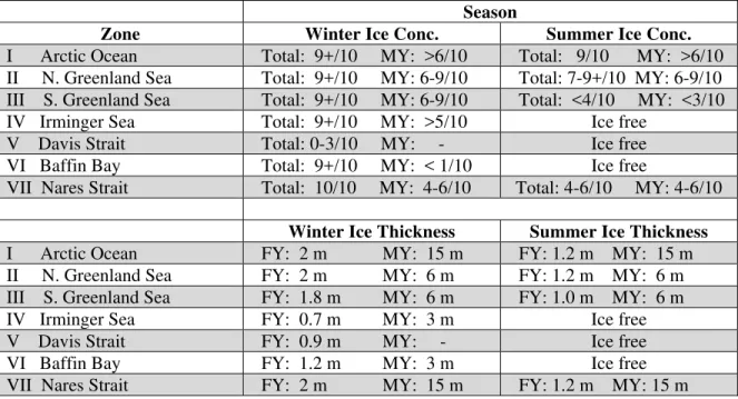
For each navigation area, typical ice concentration and ice thickness values are given in Table 1 for the winter and summer. These data, as well as the definition of summer and winter in each region, are based on ice charts from the Canadian Ice Service [2], the Danish Ice Service [3] and the U.S. National Ice Center [4]. These data represent the average ice conditions and are not intended for design purposes. There is significant variability year to year particularly in zones III through VI.
Table 1 Typical ice concentrations for the total sea ice cover (Total) and multi-year ice (MY) in each navigation area
Season
Zone Winter Ice Conc. Summer Ice Conc.
I Arctic Ocean Total: 9+/10 MY: >6/10 Total: 9/10 MY: >6/10 II N. Greenland Sea Total: 9+/10 MY: 6-9/10 Total: 7-9+/10 MY: 6-9/10 III S. Greenland Sea Total: 9+/10 MY: 6-9/10 Total: <4/10 MY: <3/10 IV Irminger Sea Total: 9+/10 MY: >5/10 Ice free
V Davis Strait Total: 0-3/10 MY: - Ice free
VI Baffin Bay Total: 9+/10 MY: < 1/10 Ice free
VII Nares Strait Total: 10/10 MY: 4-6/10 Total: 4-6/10 MY: 4-6/10
Winter Ice Thickness Summer Ice Thickness
I Arctic Ocean FY: 2 m MY: 15 m FY: 1.2 m MY: 15 m II N. Greenland Sea FY: 2 m MY: 6 m FY: 1.2 m MY: 6 m III S. Greenland Sea FY: 1.8 m MY: 6 m FY: 1.0 m MY: 6 m
IV Irminger Sea FY: 0.7 m MY: 3 m Ice free
V Davis Strait FY: 0.9 m MY: - Ice free
VI Baffin Bay FY: 1.2 m MY: 3 m Ice free
OCRE-TR-2013-002 3
Icebergs are present year-round in Greenland waters, the majority are found in eastern Baffin Bay (zone VI) where 20-25,000 icebergs are calved each year [1]. Source glaciers for icebergs are found in every other navigation area but they are less productive.
1.2 Selection of the appropriate ice class
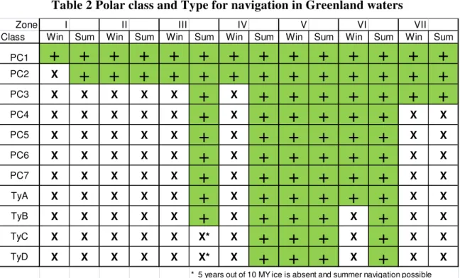
Greenland/Denmark has not developed an ice class system unique to Greenland territorial waters, but supports the long term goal of making mandatory the IMO Guidelines for ships operating in polar waters [5]. Based on a qualitative assessment of ice conditions in the navigation areas defined in Figure 1, appropriate ice class for winter (Win) navigation and summer (Sum) navigation of IACS Polar Class [6] and the four highest Canadian Type classes [7] are indicated in Table 2. For the northern regions (I, II, II and VII), winter is November to July and summer is August to October. For the southern regions (IV, V and VI), winter is December to June and summer is July to November. Note that Type A through Type D ships are equivalent to BV Ice Class IAS through IC, respectively. The assessment has been based on ice multipliers [7] for Type ships and a correspondence between the Polar Classes [6] and Canadian Arctic Classes [7]. The minimum appropriate ice classes indicated are based on average ice conditions, but conditions can vary substantially from year to year, particularly in zones III through VI, so that in any one season a higher ice class might be needed for safe navigation or a lower ice class could be quite adequate. The minimum class for Polar Class and Type ships indicated in Table 2 is for unescorted navigation.
Table 2 Polar class and Type for navigation in Greenland waters
Zone I II III IV V VI VII
Class Win Sum Win Sum Win Sum Win Sum Win Sum Win Sum Win Sum
PC1
+
+
+
+
+
+
+
+
+
+
+
+
+
+
PC2 X+
+
+
+
+
+
+
+
+
+
+
+
+
PC3 X X X X X+
X+
+
+
+
+
+
+
PC4 X X X X X+
X+
+
+
+
+
X X PC5 X X X X X+
X+
+
+
+
+
X X PC6 X X X X X+
X+
+
+
+
+
X X PC7 X X X X X+
X+
+
+
+
+
X X TyA X X X X X+
X+
+
+
+
+
X X TyB X X X X X+
X+
+
+
X+
X X TyC X X X X X X* X+
+
+
X+
X X TyD X X X X X X* X+
+
+
X+
X X4 OCRE-TR-2013-002
1.3 Legislation to be followed
Greenland is not a completely sovereign state, however the Danish parliament has passed the Act on Greenland Self Government, Act No. 473 of 21 June 2009 (the ‘Self Government Act’), whereby certain powers and authorities are being transferred from Denmark to Greenland. There are provisions under the Act for Greenland to eventually assume complete sovereignty over Greenland territory. In the interim, legislation of the Danish Parliament makes provision for safety of navigation in Greenland waters.
Information on legislation, regulations and guidance on safety of navigation in Greenland waters is provided by the Danish Maritime Authority [8]. This website provides a comprehensive introduction to additional sources of information on navigation in Greenland waters. It refers to the Act on Safety at Sea, cf. Consolidated Act no. 903 of 12 July 2007, as put into force by Decree no. 882 of 25 August 2008, which contains provisions for safety of navigation in Greenland waters [9]. It sets requirements for mandatory reporting of position, course, etc. according to GREENPOS [10], navigator’s qualifications, prohibits use of open lifeboats, safety measures and regulation for the use of ice searchlights [11]
1.4 Additional interesting meteorological parameters
In addition to the general ice conditions described in Section 1, Table 3 summarizes relevant meteorological parameters. For air temperature the data represent the average minimum winter conditions. For ridges the data represent the predominant sail height (elevation above mean sea level). For wind force and ocean currents the data represent the annual maxima values. For visibility and waves (significant height and period) in winter (Win) and summer (Sum) the data represent the predominant conditions. These data are for information only and are not intended for design purposes; the values represent averages over the whole navigation area and were derived from a review of publicly available literature and data sets.
Table 3 Meteorological conditions in Greenland waters
Zone Ice Season Air To Ridges Icebergs
I Arctic Ocean all year -40 oC 6.5m high
present year-round
II N. Greenland Sea all year -35 oC 3m high
present year-round III S. Greenland Sea all year -25 oC 1m high
present year-round IV Irminger Sea north: Jan – Jun
south: Nov - Jun
-12 oC ND* many/year
present year-round V Davis Strait north: Dec-May
south: ice free
-25 oC ND many/year
present year-round
VI Baffin Bay Oct-July -30 oC ND 1 to 5 icebergs within 175 km2
present year-round
VII Nares Strait all year -35 oC ND few/year
present year-round *ND:no data
OCRE-TR-2013-002 5
*ND:no data ** percent of the total time in July
2 REFERENCES
[1] Weather, sea and ice conditions offshore West Greenland – Focusing on new license areas, 2004. Greenland Bureau of Minerals and Petroleum.
<www.geus.dk/ghexis/pdf/weather_ice_2004.pdf>
[2] Canadian Ice Service – Environment Canada, 30-year Climatic Atlas, 2011. <http://www.ec.gc.ca/glaces-ice>
[3] National Ice Center Arctic Sea Ice Charts and Climatologies in Gridded Format <http://nsidc.org/data/g02172.html>
[4] Danish Ice Center – Danish Meteorological Institute, Regional Ice Charts <www.dmi.dk/dmi/en>
[5] IMO Guidelines for ships operting in polar waters
<http://www.soefartsstyrelsen.dk/SiteCollectionDocuments/CMR/Sejladssikkerhe d,%20GMDSS%20og%20SAR/A.1024(26)%20Guidelines%20for%20ships%20o perating%20in%20polar%20waters.pdf>
[6] IACS Unified requirements concerning Polar Class – International Association of Classifications Societies, Octover 2007.
<http://www.iacs.org.uk/publications/publications.aspx?pageid=4§ionid=3>
[7] Arctic Ice Regime Shipping System (TP 12259) – Transport Canada, June 2008. <http://www.tc.gc.ca/MarineSafety/TP/Tp12259/menu.htm>
[8] Safety of navigation in Greenland waters
<http://www.dma.dk/ships/sider/greenlandwaters.aspx>
Zone Wind Force
Current Visibility (Win/Sum)
Waves (height – period) (Win/Sum)
I Arctic Ocean ND* ND ND ND
II N. Greenland Sea 25 m/s 30 cm/s clear/ND ND
III S. Greenland Sea 15 m/s 30 cm/s clear/ND ND
IV Irminger Sea 25 m/s 30 cm/s clear/20%-30%** 4m – 9 s / 1.5m – 8s V Davis Strait 30 m/s 35 cm/s clear/20%-30% 4m – 8s / 1.8m – 7s
VI Baffin Bay 20 m/s 10 cm/s clear/20%-30% ND / 1m -6s
6 OCRE-TR-2013-002
[9] Order on technical regulation on safety of navigation in Greenland territorial waters, Order no. 417 of 28 May 2009 issued by the Danish Maritime Authority <http://www.dma.dk/SiteCollectionDocuments/Legislation/Orders/2009/BEK-417-28052009-<sejlads%20i%20groenlandsk%20soeterritorium.pdf>
[10] Information about the GREENPOS System:
<http://forsvaret.dk/GLK/GREENPOS/GREENPOS%20IN%20ENGLISH/Pages/ default.aspx>
[11] Technical regulation on the use of ice searchlights during navigation in Greenland waters, Technical Regulation no. 169 of 4 March 2009 issued by the Danish Maritime Authority
<http://www.dma.dk/SiteCollectionDocuments/Legislation/Technical%20regulati ons/2009/TF%20169-04032009-isprojektoerer%20ved%20groenland.pdf>
OCRE-TR-2013-002 A-1
SUPPLEMENT
Where appropriate, further detail on source data and methods are provided for each section in the Greenland chapter.
1. Typical ice conditions
Definition of navigation areas: The main source of data used to define the navigation areas are the regional ice charts from the Canadian Ice Service (CIS), the U.S. National Ice Center (NIC) and the Danish Ice Service (DMI). The regional ice charts are weekly and contain information on ice concentration and ice type. Ice charts covering that last 20 years in both the winter and summer seasons were reviewed. The analysis of ice conditions based on ice multipliers for different ship types used in the assessment for the selection of the appropriate ice class in Section 2, was also used to help define the navigation areas.
Typical ice concentrations: Data in Table 1 for typical ice concentrations in each area for the winter and summer seasons are based on the ice charts. These values represent the average ice conditions and are not intended for design purposes. There is considerable variability from year to year and ice conditions can be more severe or considerably lighter than what is reported in Table 1. For zones I, II, III and VII, summer is August to October and winter is November to July. For zones IV, V and VI, summer is to July to November and winter is December to June.
Typical ice thickness: Ice thickness data for first-year ice and multi-year ice are based on published field observations and reported values for the mean maximum ice thickness in the literature. These values represent the average ice conditions and are not intended for design purposes. There is considerable variability from year to year and ice conditions can be more severe or considerably lighter than what is reported in Table 1. For zones I, II, III and VII, summer is August to October and winter is November to July. For zones IV, V and VI, summer is to July to November and winter is December to June.
2. Selection of appropriate ice class
Sea ice data used in the assessment is the most recent 20-year record of regional ice charts (CIS, NIC, DMI). Winter ice conditions were taken at the end of March, and summer at mid-September. These dates represent the likely maximum and minimum of ice severity, and the conditions on average would not change +/- one month from this date. Average ice conditions (partial concentrations and stage of development) for a number of years were qualitatively estimated and combined with Ice Multipliers from the Arctic Ice Regime Shipping System (AIRSS), see Table 7 of BV NI 543, to determine an Ice Numeral. If the numeral was negative, that class/type of ship would not be allowed access. Note that the Ice Numerals determined varied both temporally and spatially, so again judgment had to be used to establish a minimum acceptable ice class. For zones I, II, III and VII, summer is August to October and winter is November to July. For zones
A-2 OCRE-TR-2013-002
IV, V and VI, summer is to July to November and winter is December to June. These definitions of a winter period are conservative, in that at the beginning and end of the season, ice conditions will be milder. They have been accordingly set to not encourage too early or too late entry into a zone by a class or type ship.
3. Legislation to be followed
Supplemental information is not available.
4. Additional interesting meteorological parameters
Ice Season: The length of the ice season was defined based on the most recent 20-year record of regional ice charts from the CIS, NIC and DMI.
Air temperature: The mean minimum winter air temperature is based on the most recent 20-year record of temperature data from Greenland station data and modeled reanalysis data, NCEP/NCAR Reanalysis. Values represent averages over whole sea regions and are not intended for design purposes.
www.esrl.noaa.gov/psd/data/gridded/data.ncep.reanalysis.html
Ridges: Ridge height data for zones I, II and III, is from a database of ridge statistics that was compiled from the public literature by the National Research Council of Canada. No data is available for zones III through VII.
Icebergs: The density and occurrence of icebergs is highly variable Data on the average density of icebergs expressed as the number of icebergs found in a 2-degree latitude by 1-degree longitude area in Baffin Bay (Zone VI) is from [1]. Observations of icebergs are noted on the regional Canadian and Danish ice charts as a symbol, the data is qualitative and exact locations or numbers are not given. A qualitative estimate of the number of icebergs in zones IV, V and VII is derived from the ice charts. Iceberg symbols were not present in zones I, II or III although it is known that icebergs are present in these regions. The ice charts are a guide for navigation and the lack of observations in these zones likely reflects limited shipping activity.
Wind force, ocean current and visibility: Wind force and current data are based on a review of the available literature. Key references are [1], [2] and [3].
Waves – significant wave height and period: Significant wave height and period are from modeled reanalysis data, Wavewatch III. Values represent averages over whole sea regions and are not intended for design purposes. Data is not available when sea ice present.
OCRE-TR-2013-002 A-3
REFERENCES
[1] Weather, sea and ice conditions in eastern Baffin Bay, offshore Northwest Greenland. Danish Meteorological Institute Tech. Rep. 96-12. 39p.
<www.geus.dk/ghexis/pdf/baffinb.pdf>
[2] Weather, sea and ice conditions offshore West Greenland – Focusing on new license areas, 2004. Greenland Bureau of Minerals and Petroleum.
<www.geus.dk/ghexis/pdf/weather_ice_2004.pdf>
[3] The circulation, water masses and sea-ice of Baffin Bay, 2004. Bedford Institute of Oceanography, Fisheries and Oceans Canada.