HAL Id: hal-01893509
https://hal.uca.fr/hal-01893509
Submitted on 11 Oct 2018
HAL is a multi-disciplinary open access
archive for the deposit and dissemination of
sci-entific research documents, whether they are
pub-lished or not. The documents may come from
teaching and research institutions in France or
abroad, or from public or private research centers.
L’archive ouverte pluridisciplinaire HAL, est
destinée au dépôt et à la diffusion de documents
scientifiques de niveau recherche, publiés ou non,
émanant des établissements d’enseignement et de
recherche français ou étrangers, des laboratoires
publics ou privés.
Precipitation and microphysical studies with a low cost
high resolution X-band radar: an innovative project
prospective
Joël van Baelen, Y. Pointin, W. Wobrock, A. Flossmann, G. Peters, F.
Tridon, C. Planche
To cite this version:
Joël van Baelen, Y. Pointin, W. Wobrock, A. Flossmann, G. Peters, et al.. Precipitation and
mi-crophysical studies with a low cost high resolution X-band radar: an innovative project prospective.
Advances in Geosciences, European Geosciences Union, 2009, 20, pp.25 - 32.
�10.5194/adgeo-20-25-2009�. �hal-01893509�
www.adv-geosci.net/20/25/2009/
© Author(s) 2009. This work is distributed under the Creative Commons Attribution 3.0 License.
Advances in
Geosciences
Precipitation and microphysical studies with a low cost high
resolution X-band radar: an innovative project prospective
J. Van Baelen1, Y. Pointin1, W. Wobrock1, A. Flossmann1, G. Peters2, F. Tridon1, and C. Planche1
1Laboratoire de M´et´eorologie Physique, UMR6016, CNRS/Universit´e Blaise Pascal Clermont-Ferrand II, 24 avenue des
Landais, 63177 Aubi`ere, France
2Meteorologisches Institut, Universitaet Hamburg, Bundesstraße 55, 20146 Hamburg, Germany
Received: 22 September 2008 – Revised: 6 March 2009 – Accepted: 7 March 2009 – Published: 16 March 2009
Abstract. This paper describes an innovative project which has just been launched at the “Laboratoire de M´et´eorologie Physique” (LaMP) in Clermont-Ferrand in collaboration with the “Meteorologische Institut” in Hamburg, where a low cost X-band high resolution precipitation radar is combined with supporting measurements and a bin microphysical cloud resolving model in order to develop adapted Z−R relation-ships for accurate rain rate estimates over a local area such as a small catchment basin, an urban complex or even an agri-culture domain.
In particular, the use of K-band micro rain radars which can retrieve vertical profiles of drop size distribution and the associated reflectivity will be used to perform direct com-parisons with X-band radar volume samples while a network of rain-gauges provides ground truth to which our rain es-timates will be compared. Thus, the experimental suite of instrumentation should provide a detailed characterization of the various rain regimes and their associated Z−R relation-ship. Furthermore, we will make use of the hilly environment of the radar to test the use of novel attenuation methods in or-der to estimate rainfall rates.
A second important aspect of this work is to use the de-tailed cloud modeling available at LaMP. Simulations of pre-cipitating clouds in highly resolved 3-D dynamics model al-low predicting the spectra of rain drops and precipitating ice particles. Radar reflectivity determined from these model studies will be compared with the observations in order to better understand which raindrop size spectrum shape factor should be applied to the radar algorithms as a function of the type of precipitating cloud. Likewise, these comparisons
Correspondence to: J. Van Baelen ([email protected])
between the modeled and the observed reflectivity will also give us the opportunity to further improve our model micro-physics and the parameterizations for meso-scale models.
1 Introduction: project objectives
The primary goal of this project is to develop a robust, mo-bile, low cost X-band radar in order to localize and quantify precipitation with high spatial and temporal resolution over areas equivalent to urban areas, small catchments basins or even extended agriculture domains. Such a tool is not yet readily available in the meteorological community as only a few commercial or one-of-a-kind research dedicated systems exist. Although limited in its range of capabilities, such a radar system can adequately support a wide range of scien-tific studies on convective and precipitating system processes due to its high spatial resolution and its high mobility. Addi-tionally, it offers various civil applications involved with rain estimation such as water runoff and retention basin manage-ment, flood risk warning, as well as precipitation monitoring for agriculture, while its low cost would make it easily acces-sible to the user community.
As it is the aim of the project to provide reliable estimates of rainfall rate with a very high spatial and temporal resolu-tion, comparative studies with precipitation estimates deter-mined with other remote sensing or in-situ instruments will also be carried out. Furthermore, radar reflectivity is a vol-ume integrated measure of the number/size distribution of liquid and solid hydrometeors. Thus, in order to better un-derstand the relationship between radar reflectivity and the size distribution of the hydrometeors, this radar work will be accompanied by cloud model studies within a 3-D, highly
26 J. Van Baelen et al.: Precipitation and microphysical studies with a low cost high resolution X-band radar
resolved dynamical frame. Likewise, the use of a detailed bin resolved mixed-phase microphysics model developed at LaMP for cloud and precipitation spectra will make it pos-sible to determine the dependence of the raindrop size spec-trum shape parameter on location, time, and type of the mea-sured clouds such that advanced restitution algorithms can be developed. In addition, the comparison of the simulated precipitation with the observed reflectivities will allow us to improve our understanding of the microphysical processes responsible for the rain formation and thus will result in the improvement of the precipitation parameterizations used for synoptic and meso-scale models. Hence, in this work, it-erations between the radar measurements and the modeling efforts will advance the development of both areas of the project.
2 General scientific background 2.1 Cloud drops life cycle
Lifting of moist air parcels, be it due to convection, oro-graphic forcing, or any other mechanism, will cause their temperatures to fall and approach dew point temperatures. Then, cloud droplets nucleate when water vapor condensate on aerosol particles which act as condensation nuclei. Such condensation nuclei, e.g. aerosols, can be solid particles or hygroscopic liquids, both of natural or man-made origin, and present variable nucleation efficiency. To condensate around the nuclei a super-saturation is required. Once the droplets form, condensation is too slow a process to generate pre-cipitating drops within the usual lifetime of a cloud. Thus, coalescence of colliding drops is needed to produce sizable drops. The smallest drops are essentially spherical and tend to become more oblate as they grow (Pruppacher and Pitter, 1971). Larger drops deform to get a flattened then concave base. That structure becomes unstable and tends to breakup into smaller drops. Thus, the spectrum of drops size distri-bution tends towards equilibrium between coalescence and breaking-up of drops (Srivastava, 1974). Most mid-latitude clouds, however, pass via the ice phase for precipitation for-mation. Here, in an initial state, certain aerosol particles called IN (Ice forming nuclei) form small ice crystals or small droplets freeze. The small initial crystals grow rapidly by vapor deposition and then collide with other crystals or liquid drops to reach the size of graupel particles or snow flakes. Depending on the zero degree altitude in the atmo-sphere, these graupel particles can melt before reaching the ground. Here, equally in the final stage an equilibrium dis-tribution can be reached allowing the representation of the size distribution by a constant raindrop size spectrum shape factor. For a thorough review of cloud physics, the reader is referred to Rogers and Yau (1989) or Houze (1993).
2.2 Radar measurement of precipitation
Since the advent of radar meteorology after the Second World War, it has been a continuous quest in the meteorologi-cal community to design ways to retrieve precise lometeorologi-calization of precipitation and quantification of rain rates with radars. This endeavor has proven difficult and nowadays much re-search work is still being carried out on that topic.
Given that the weather radar returns are caused by backscattering of the electromagnetic waves upon the hy-drometeors present in the illuminated radar beam, an accu-rate estimate of rainfall accu-rates requires a detailed knowledge of the drop size distribution of rain (DSD: the number den-sity of water droplets in a unitary volume as a function of their diameter).
Although it is not a unique representation, it is customary to use the Marshall-Palmer relationship to describe the DSD. This is an exponential formula with two parameters which have been shown to be dependant on the rain fall rate (R). Other distributions, such as truncated exponential function, Gamma functions, are sometimes used in the literature. In fact, the actual drop size spectra can differ quite significantly from a unique representation according to the type of rain encountered which can be not only geographically and sea-sonally dependant but can also vary within a complex pre-cipitating system (Battan, 1973; Joss and Gori, 1978). For radars with a single parameter measurement capability (i.e., single frequency, no dual polarization), it is possible, under some assumptions and with careful selection of operational coefficients, to estimate the rain fall rate from the measured reflectivity factor (Z). For further readings and references, one would suggest Wilson and Brandes (1979) and the books by Doviak and Zrnic (1984), and Rinehart (2004).
Currently, there are two main kinds of radar systems in use in the meteorological community. The first ones are the op-erational weather radars from the national weather services. These radars are most often S- or C-band systems with an extended range (a couple hundred of kilometers) in order to survey as wide an area as possible. Many of them have vol-ume scan and/or Doppler capabilities while they are usually operated under fixed pre-set observation schemes. They all have in common to be very expensive. The second category of radars is the research radars. They are most often one of kind type of radars designed to explore new technologies and offer new insights into meteorological research. They can be operated in S (rarely), C (sometimes), or X (most of-ten for more portability) band. Most of them are Doppler and have dual polarization and/or dual frequency with vol-ume scan capabilities. These are priceless research tools but are also very expensive. Looking into existing radar systems in the research community which could prefigure our project, one could mention the “Doppler on Wheels” radars in the US for mobility (Wurman et al., 1997), or the French X-port radar for precipitation studies (Gosset et al., 2004), although these are much more expensive when compared to our goals.
J. Van Baelen et al.: Precipitation and microphysical studies with a low cost high resolution X-band radar 27
Also there exists a few commercial “mini” weather radars, but they are still an order of magnitude more costly than what we target in this project. Finally, the closest development to date which resembles our project is a radar built by the Dan-ish Hydrological Institute (Rollenbeck and Bendix, 2005). It also uses a modified navigation radar, but has kept the orig-inal wave-guide antenna such that the beam characteristics limit the application of such a system to stratiform rain over fairly flat terrain.
2.3 Clouds micro-physical processes modeling
Concerning actual models to represent clouds, the literature displays a large variety of choices. The models have a dif-ferent complexity concerning the dynamics, going from a simple parcel model approach, passing by 1-D and 2-D rep-resentations, until the full 3-D representation of the model domain, with large scale forcing and interactive grid nesting. Equally, concerning the microphysics different schemes of increasing complexity exist. Most global models only treat a single variable for condensed water, while synoptic and meso-scale models consider up to five reservoirs for small and large drops, small and large ice particles and snow. Only a few models exist that follow explicitly the drop and ice par-ticle spectra at every grid point of the model. And still less of these models are coupled to a full 3-D framework. Some examples of such models were developed in Israel (Lynn et al, 2005), and the US (Ovtchinnikov and Kogan, 2000), and recently at LaMP (Leporini, 2005). Equally at LaMP activi-ties exist to simplify the spectral microphysics models to bulk mode parameterizations (Caro et al, 2004). These parameter-izations need an assumption on the shape of the hydrometeor spectra which often lack justification.
3 The observational strategy
The rationale behind the current project is to develop the nec-essary know-how to retrieve good quality estimates of pre-cipitation with the newly developed X-band radar (Fig. 1) by comparing the retrieved parameters with other available remote sensing and in-situ measurements, as well as cloud microphysical processes modeling results.
3.1 The X-band precipitation radar
The base of the radar consists of a modified version of com-mercially available navigation radar in order to provide 2-D maps of reflectivity. However, in order to improve the return signal characteristics, and thus the rain estimation capabili-ties, the antenna has been changed to an off-set parabola in order to obtain a pencil beam, while the signals are accu-mulated over successive rotations of the antenna. The radar characteristics are summarized in Table 1. The typical oper-ation mode of the radar corresponds to 30 s time integroper-ation, 60 m range integration, 2◦azimuth integration.
17
Figure 1: View of the Clermont-Ferrand x-band precipitation radar without its protective radome. Parts of the city of Clermont-Ferrand and the Puy de Dôme are visible in the background.
Fig. 1. View of the Clermont-Ferrand X-band precipitation radar
without its protective radome. Parts of the city of Clermont-Ferrand and the Puy de Dˆome are visible in the background.
3.2 Development strategy and supporting measurements
Given that the radar considered is a single parameter system in order to keep its cost low; there is neither dual frequency nor polarization diversity implemented. Thus, there are a few limiting factors that must be considered in our project in or-der to obtain reasonable rainfall estimates.
First of all, the Z−R relationship is not unique and is highly dependent upon the type of precipitation encountered and its associated drop size distribution (DSD) (Battan, 1973; Doviak and Zrnic, 1993). However, our radar exhibits a very high spatial resolution which works in our favor by reducing the heterogeneity of the atmospheric environment within the sampled volume.
To help us in defining the most appropriate reflectivity/rain rate (or Z−R) relationships for our radar but also to calibrate our X-band radar, we compare the X-band radar reflectiv-ity with direct measurement of the reflectivreflectiv-ity and drop size distribution evaluated by a vertically looking K-band micro-rain radar (Peters et al., 2002; Peters et al., 2005) which has been calibrated in laboratory using the procedures described in Peters et al. (2005). Then the X-band radar calibration is performed by statistical comparison with micro rain radar measurements observed during selected rain event.
As the X-band radar beam intersects with the micro rain radar beam, this gives us insights into the different rain in-tensities and rain regimes and their associated X-band radar signal reflectivity. An example of direct comparison of the X-band radar and MRR reflectivity in their common volume
28 J. Van Baelen et al.: Precipitation and microphysical studies with a low cost high resolution X-band radar
Table 1. X-band radar operational characteristics.
Frequency 9410±30 MHz Peak power 12 kW
Pulse width/Pulse repetition frequency 0.8 µs/600 Hz or 0.3 µs/1200 Hz or 0.08 µs/2100 Hz Sampling rate 10 MHz
Scan rate 24 revolutions per minute Antenna gain 30 dB
Half power beam width 2.4◦
Beam elevation Fixed elevation during operation but mechanically adjustable from 2 to 20◦ Range (expected maximum useful) 20 km
18
Figure 2: Reflectivity from the X band radar (red curve), the MRR (green curve) and estimated from the disdrometer measurements (red curve) while the surface temperature is provided by a dash line.
Fig. 2. Reflectivity from the X-band radar (red curve), the MRR
(green curve) and estimated from the disdrometer measurements (red curve) while the surface temperature is provided by a dash line.
is provided in Fig. 2 along with a ground estimate of such reflectivity derived from the available disdrometer measure-ments. While the agreement is very good between these vari-ous curves, long term measurements in common atmospheric cell volumes with these two instruments under various pre-cipitation conditions will provide us with a valuable database from which to assess different Z−R relationships and their domain of validity. Indeed, it is well known that precipitation characteristics can be sensibly different according to various rain regimes (for example stratiform, convective, etc.) but can also vary significantly within a single precipitation event (i.e., differences between the onset and the trailing end of the rain system, internal sub-structures and enhancements). Therefore, the keystone of our approach is to be able to iden-tify rain regime classes based on subjective criteria such as
intensifying or decaying rain intensity (Van Baelen et al., 2006, 2009), or statistical temporal stability (Clemens et al., 2008)
Likewise, a network of rain-gages and disdrometers pro-vides “ground truth” for the validation of rainfall rate esti-mates which will be derived from the radar measurements. Although, some caution must be used in such comparisons (Wilson, 1979), they are the back-bone of validation of rain-fall estimates by radars. However, it is important to have at disposal a large enough set of ground measurements in order to be able to picture accurately the rain rate distribution and its variability on the ground as it has been demonstrated that the denser the network the more accurate the rainfall field retrieval can be (Hildebrand et al., 1979). Thus, we need to be able to capture the rainfall at the various locations of the precipitation system, while accounting for the radar spatial resolution. Currently we rely on a network of 18 rain gages all within 10 km of the radar site.
Another limitation with our radar will arise from the X-band signal attenuation associated with the propagation of the electromagnetic wave through rain. To circumvent this effect, we apply the well known Hitschfeld and Bor-dan (1954) algorithm with statistically determined parame-ters based on the study of multiple rain events. However, this method has some limitations because it relies on a-priori drop size distribution factors but also in case of strong precipita-tion and precipitaprecipita-tion gradients. Therefore, we limit attenu-ation correction to 10 dBz beyond which value we consider that it is no longer possible to determine a realistic attenu-ation correction. Hence, we are currently considering alter-native calibration methods based on differential ground tar-get reflection between rain ad no-rain events. These recently developed methods should allow for retrieval of the path-integrated attenuation following the work of Fabry, 2004; Delrieu et al., 1999a, b. Under some assumptions, the atten-uation measured is representative of the scan region affected by rain. This method could also be applicable in the con-text of partially filled beams (Gosset and Zawadzki, 2001). Although this area of work and development is still uncer-tain, we think that the use of multiple micro-rain radars po-sitioned along a single X-band radar beam in the direction
19
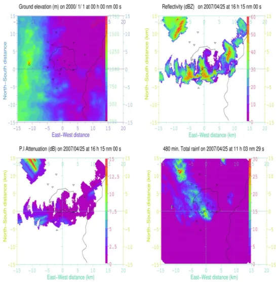
Figure 3: (a) Radar environment orography with the Puy de Dôme to the West and the markers to identify the rain-gages location while the solid lines indicate the contour of Clermont-Ferrand and the Allier river; (b) Reflectivity display of the X band scanning radar; (c) Estimated Path Integrated Attenuation display for the X band scanning radar; (d) Derived 8 hour accumulated precipitation display with the X band scanning radar.
Fig. 3. (a) Radar environment orography with the Puy de Dˆome to the West and the markers to identify the rain-gages location while the solid
lines indicate the contour of Clermont-Ferrand and the Allier river; (b) Reflectivity display of the X-band scanning radar; (c) Estimated Path Integrated Attenuation display for the X-band scanning radar; (d) Derived 8 h accumulated precipitation display with the X-band scanning radar.
of an identified mountain echo such as the nearby Puy de Dˆome (∼11 km from the radar) will be very beneficial. Such measurements will enable the estimation of partial attenua-tion along the X-band radar beam according to the rain field experienced and provide useful information on the attenua-tion along the path. Hence, we expect to complement our experimental set-up with additional micro rain radars soon.
4 The cloud micro-physical model
The dynamic framework employed in the present study is the three-dimensional model developed by Clark and co-workers (e.g. Clark, 1977, 1979; Clark and Farley, 1984; Clark and Hall, 1991). This model is an established tool for the simu-lation of the airflow and the formation of clouds over com-plex terrain on small meteorological scales (see, e.g., Clark
and Gall, 1982; Clark et al., 1994; Bruintjes et al, 1994, 1995; and Wobrock et al, 1997, 2003). The present non-hydrostatic version of the code uses a terrain following verti-cal co-ordinate with a user-defined spacing.
Furthermore, to describe the system microphysical char-acteristics within this work, we use the model DESCAM, i.e., the Detailed SCAvenging and Microphysical model, as discussed in Flossmann et al. (1985, 1988). It has recently been extended to a bin resolved treatment of the ice phase (Leporini, 2005). This microphysical model is linked to the dynamics in a fully interactive 3-D manner and allows the representation of the cloud that is observed by the radar in a highly resolved manner, concerning both the spatial and the microphysics resolution. This model is used to identify in cloud life periods where a constant hydrometeor size distri-bution spectrum shape parameter can be found. For this, the model will be extended to calculate radar reflectivity from
30 J. Van Baelen et al.: Precipitation and microphysical studies with a low cost high resolution X-band radar
20
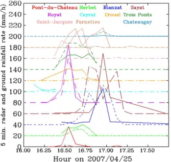
Figure 4: Time series of 5 minute radar and ground rainfall rates for the different rain-gauge
sites. Each successive site is augmented by 20mm/h for visibility. Dash lines for rain gages observations, solid lines for X band radar estimations.
Fig. 4. Time series of 5 min radar and ground rainfall rates for
the different rain-gauge sites. Each successive site is augmented by 20 mm/h for visibility. Dash lines for rain gages observations, solid lines for X-band radar estimations.
the droplet, ice and mixed phase particle spectra. They will be compared to the radar observations.
In a second step, we will adapt the microphysical code such that the drop and ice particle size distributions are pa-rameterized by generalized gamma distributions (Caro et al., 2004). To do so, the parameters obtained by the detailed calculations and in agreement with the radar observations will be used to improve the parameterization of the spectra. This parameterized code can then be more easily applied to simulations of clouds on the synoptic-scale covering several 1000 km.
5 Examples of ongoing investigations
Figure 3 illustrates some of the preliminary work we have carried out with the set of instruments currently deployed. The example shown corresponds to the 25th of April 2007 event with was characterized with some intense localized precipitations over the area of Clermont-Ferrand.
Panel (a) shows the local orography surrounding the radar. It appears clearly that the city of Clermont-Ferrand, marked by a solid line, is bordered to the west by mountainous ter-rain, with a high point being the Puy de Dˆome (indicated by a cross) about 1000 m above the city floor. Likewise, the east side of the city opens to flat agricultural lands.
In panel (b), the 30 s, 60 m resolution radar reflectivity, expressed as Z=C P r2, where P is the received power, r the range and C a calibration constant, is shown after ground
clutter has been removed. Individual precipitation cells of only a few hundred meters are clearly visible.
In the current application, the ground clutter is determined as a 5 min average of received power over the entire area visible to the radar under clear sky conditions, assuming that when no hydrometeor is present only clutter will produce sig-nificant echo power, while time averaging will limit fluctuat-ing noise effects. The correspondfluctuat-ing mask is then subtracted from any subsequently measured scene. That approximation is mostly correct due to the short range of the radar observa-tions. However, in case of light rain event, wet structures such as rooftops, antennas, etc. can provided slightly in-creased clutter returns which will induce possible errors in the measured reflectivity and, hence, rain rate estimates. We are aware of this limitation but we don’t have yet defined or implemented a method to deal with this limitation.
The Path Integrated Attenuation derived using the algo-rithm of Hitschfeld and Bordan (1954) which is sensible as long as the attenuation is less than about 10 dBZ is shown in panel (c). Once data have been corrected for attenuation, rain rate is calculated using, in this case, a standard Marshall and Palmer (1948) Z−R relationship panel. That is what is pre-sented in panel (d): the resulting 8 h accumulated rain field associated with this event.
In the future, the study of the common volume between the X-band radar and the vertically pointing MRR will allow us to define Z−R relationships specific to the rain regime which characterizes the event (or parts of the event) consid-ered. Likewise, more evolved attenuation correction schemes will be implemented and tested.
In order to asses our results (i.e., rainfall rate estimates with the X-band radar), we performed comparisons with the various rain gauges available through out the area. Figure 4 shows the time series of 5 min averaged rainfall rates (in mm/h) for the reporting rain gages at that time, each in a different colour, while the dash lines correspond to the rain gage data and the solid lines to the radar estimated results. Overall the agreement is satisfactory although discrepancies can be noted while the radar seems to produce overestimates at times. Of course we need to verify such trend on many more cases and also adopt adapted Z−R relationships rather than a standard distribution.
6 Conclusion and prospective
The instrument ensemble that has been put together to mon-itor the Clermont-Ferrand basin should provide a very inter-esting data base over time in order to study precipitation het-erogeneity, propose rain regime classification at scales equiv-alent to or even smaller than the event size itself, and develop adapted Z−R relationships for improved rain rate estima-tion. Furthermore, the high spatial and temporal resolution should provide new insights into the internal dynamics of convective and precipitating events.
Early results are encouraging and indicate that the high resolution of the radar coupled with the rain spectra measurement of the MRR will provide very useful and ac-curate products within its scope of applications.
Beyond its scientific involvement in microphysical studies of cloud and precipitation system with its high space and time resolution, the proposed radar suite appears also well suited for a wide range of surveillance and risk management oper-ations (such as flash flood warning for civil security, urban communities storm basin management, agricultural surveil-lance and monitoring) while its cost will make it affordable to such civilian and private entities. Therefore, we plan to demonstrate the radar and system capabilities and develop the necessary environment for a highly mobile system within a real time display environment of the various radar measure-ments and products as well as model simulations.
Acknowledgements. The technical support of the “Observatoire
de Physique du Globe de Clermont-Ferrand” and the Clermont Community provision of the rain-gauge data are gratefully ac-knowledged. Financial support to acquire the radar was provided under the auspices of the Auvergne Regional Project PREVOIR.
Edited by: S. C. Michaelides
Reviewed by: two anonymous referees
The publication of this article is financed by CNRS-INSU.
References
Atlas, D., Srivastava, R., and Sekhon, R.: Doppler radar character-istics of precipitation at vertical incidence, Rev. Geophys. Space Phys., 11, 1–35, 1973.
Battan, L. J.: Radar observations of the atmosphere, Univ. of Chicago Press, 1973.
Bruintjes R. T., Clark, T. L., and Hall, W. D.: Interaction between topographic airflow and cloud/precipitation developement during the passage of a winter storm in Arizona, J. Atmos. Sci., 51, 48– 67, 1994.
Bruintjes R. T., Clark, T. L., and Hall, W. D.: The dispersion of tracer plumes in mountainous regions in Central Arizona: Com-parison between observations and modelling results, J. Appl. Met., 34, 971–988, 1995.
Caro, D., Wobrock, W., Flossmann, A. I., and Chaumerliac, N.: A two-moment parameterization of aerosol nucleation and im-paction scavenging for a warm cloud microphysics: description and results from a two-dimensional simulation, Atmos. Res., 70(3-4), 171–208, 2004.
Clark, T. L.: A small scale dynamic model using a terrain-following coordinate transformation, J. Comput. Phys., 24, 186–215, 1977.
Clark, T. L.: Numerical simulations with a three dimensional cloud model: Lateral boundary condition experiments and multi-cellular severe storm simulations, J. Atmos. Sci., 36, 2191–2215, 1979.
Clark, T. L. and Gall, R.: Three dimensional numerical model sim-ulations of air flow over mountainous terrain: A comparison with observations, Mon. Weather Rev., 110, 766–791, 1982. Clark, T. L. and Farley, R. D.: Severe downslope windstorm
cal-culations in two and three spatial dimensions using anelastic in-teractive grid nesting: A possible mechanism for gustiness, J. Atmos. Sci., 41, 329–350, 1984.
Clark, T. L. and Hall, W. D.: Multi-domain simulations of the time dependent Navier-Stokes equations: benschmark error anal-ysis of some nesting procedures, J. Comput.Phys., 92, 456–481, 1991.
Clark, T. L., Hall, W. D., and Banta, R. M.: Two and three di-mensional simulations of the 9 Jan 1989 severe Boulder wind-storm: comparison with observation, J. Atmos. Sci, 51, 2317– 2342, 1994.
Clark, T. L., Jenkins, M. A., Coen, J., and Packham, D.: A cou-pled atmosphere – fire model: convective feedback on fire-line dynamics, J. Appl. Meteor., 35, 875–901, 1996.
Delrieu, G., Hucke, L., and Creutin, J.-D.: Attenuation in rain for X- and C-band weather radar systems: Sensitivity with respect to the drop size distribution, J. Appl. Meteor., 38, 57–68, 1999a. Delrieu, G., Serrar, S., Guardo, E., and Creutin, J.-D.: Rain mea-surement in hilly terrain with X-band weather radar systems: accuracy of path-integrated attenuation estimates derived from mountain return, J. Atmos. Ocean. Technol., 16, 405–416, 1999b. Doviak, R. J., and Zrnic, D. S.: Doppler radar and weather
observa-tions, 2nd edition, Academic Press, 562 pp., 1993.
Fabry, F.: Meteorological value of ground target measurements by radar, J. Atmosp. Ocean. Technol., 21, 560–573, 2004.
Flossmann, A. I., Hall, W. D., and Pruppacher, H. R.: A theoreti-cal study of the wet removal of atmospheric pollutants, Part I. J. Atmos. Sci., 42, 582–606, 1985.
Flossmann, A. I. and Pruppacher, H. R.: A theoretical study of the wet removal of atmospheric pollutants. Part III: The uptake, re-distribution, and deposition of (NH4)2SO4particles by a con-vective cloud using a two-dimensional cloud dynamics model, J. Atmos. Sci., 45, 1857–1871, 1988.
Gosset, M. and Zawadzki, I.: Effect of non-uniform beam filling on the propagation of the radar signal at X-band frequencies, J. Atmos.Ocean. Technol., 18, 113–1126, 2001.
Gosset, M., Zahiri, E. P., and Gouget, V.: Use of a mesoscale model and a radar simulator to analyze the feasibility of X-band radar retrieval algorithms, Proceedings of ERAD 2004, 347–351, 2004.
Hitschfeld, W. and Bordan, J.: Errors inherent in the radar mea-surements of rainfall at attenuation wavelengths, J. Meteor., 11, 58–67, 1953.
Houze Jr., R. A.: Cloud dynamics, Academic Press, 573 pp., 1993. Joss, J. K., and Gori, E. G: Shapes of raindrop size distributions, J.
Appl. Meteorol., 17, 1054–1061, 1978.
Leporini, M.: D´eveloppement et ´evaluation d’un mod`ele tridimen-sionnel de nuage chaud `a microphysique d´etaill´ee, Ph.D. Thesis, University Blaise Pascal, Clermont-Ferrand II, France, 149 pp., 2005.
Lynn, B. H., Khain, A. P., Dudhia, J., Rosenfeld, D., Pokrovsky,
32 J. Van Baelen et al.: Precipitation and microphysical studies with a low cost high resolution X-band radar
A., and Seifert, A.: Spectral (bin) microphysics coupled with a mesoscale model MM5, Month. Weather Rev., 133, 44–71, 2005. Marshall, J. S., and Palmer, W. M.: The distribution of raindrops
with size, J. Meteor., 5, 165—166, 1948.
Ovtchinnikov, M. and Kogan, Y. L.: An Investigation of Ice Pro-duction Mechanisms in Small Cumuliform Clouds Using a 3-D Model with Explicit Microphysics. Part I: Model Description, J. Atmos. Sci., 57(18), 2989—3003, 2000.
Peters, G., Fischer, B., and Andersson, T.: Rain observations with a vertically looking Micro Rain Radar (MRR), Bor. Environ. Res., 7, 353–362, 2002.
Peters, G., Fischer, B., Muenster, H., Clemens, M., and Wagner, A.: Profiles of Raindrop Size Distributions as Retrieved by Microrain Radars, J. Appl. Meteorol., 44, 1930–1949, 2005.
Pruppacher, H. R. and Pitter, R. L.: A semi-empirical determination of the shape of cloud and rain drops, J. Atmos. Sci., 28, 86–94, 1971.
Rinehart, D. E.: Radar for meteorologists, Fourth edition, Rinehart editions, 482 pp., 2004.
Rogers, R. R. and Yau, M. K.: A Short Course in Cloud Physics. 3rd edition. Pergamon Press, 293 pp., 1989.
Rollenbeck, R. and Bendix, J.: Experimental calibration of a cost-effective X-band weather radar for climate ecological studies in southern Ecuador, Atmos. Res., 79, 296–316, 2005.
Srivastava, R. C.: The cloud physics of particule size distributions, a review, J. Rech. Atmos., 8, 23–39, 1974.
Van Baelen, J., Brucker, L., Peters, G., Fischer, B., and Muenster, H.: Simultaneous X-band and K-band study of precipitations, 4th European Conference on Radar in Meteorology and Hydrology, Barcelona, Spain, 18–22 september, 2006.
Van Baelen, J., Tridon, F., and Pointin, Y.: Simultaneous X-band and K-band study of precipitation to derive specific Z−R rela-tionships, Atmos. Res., in press, 2009.
Wilson, J. W. and Brandes, E. A.: Radar measurement of rainfall: a summary, B. Am. Meteor. Soc., 60, 1048–1058, 1979.
Wobrock, W., Flossmann, A. I., Colvile, R. N., and Inglis, D. W. F.: Modelling of airflow and cloud fields over the northern Pennines, Atmos. Environ., 31, 2421–2439, 1997.
Wobrock, W., Flossmann, A. I., and Farley, R. D: Comparison of observed and modelled hailstone spectra during a severe storm over the Northern Pyrenean foothills, Atmos. Res., 67–68, 685– 703, 2003.
Wurman, J., Straka, J., Rasmussen, E., Randall, M., and Zahrai, A.: Design and development of a portable, pencil-beam, pulsed, 3-cm Doppler radar, J. Atmos. Ocean. Technol., 14, 1502–1512, 1997.