HAL Id: hal-01278654
https://hal.archives-ouvertes.fr/hal-01278654
Submitted on 24 Feb 2016
HAL is a multi-disciplinary open access
archive for the deposit and dissemination of
sci-entific research documents, whether they are
pub-lished or not. The documents may come from
teaching and research institutions in France or
abroad, or from public or private research centers.
L’archive ouverte pluridisciplinaire HAL, est
destinée au dépôt et à la diffusion de documents
scientifiques de niveau recherche, publiés ou non,
émanant des établissements d’enseignement et de
recherche français ou étrangers, des laboratoires
publics ou privés.
Low energy LIDARs for biomass applications
J. Lochard, J. Costeraste, F. Tinto, E. Grau, S. Durrieu, F. Fabre
To cite this version:
J. Lochard, J. Costeraste, F. Tinto, E. Grau, S. Durrieu, et al.. Low energy LIDARs for biomass
applications. SilviLaser 2015, Sep 2015, La Grande Motte, France. pp.143-145. �hal-01278654�
Low energy LIDARs for biomass applications
J, Lochard (1), J.Costeraste (2), F.Tinto (2), E.Grau (2)(3), S. Durrieu (3), F.Fabre (1)
(1) Airbus Defence and Space, 31 Av. des Cosmonautes, 31 402 Toulouse Cedex, France (2) CNES, 18 avenue Edouard Belin, 31 401 Toulouse Cedex 9, France
(3) IRSTEA, 361 rue J.F. Breton, BP 5095, 34196 Montpellier Cedex 5, France
Highlights: A new approach for LIDAR altimetry mission for biomass applications (tree height
measurement) is explored based on low emitted laser energy at high repetition frequency. Low
energy approach drastically reduces the laser induced risks. Altimetry performances meet
preliminary science requirements. The proposed instrument design is compatible with a space
mission.
Key words: Canopy height, low energy, high frequency, photon counting
Introduction
Up to now altimetry LIDAR missions in space have used the full-waveform technique. This technique implies operating energetic lasers (tens of mJ per shot) at low repetition frequency (tens of Hz). Operating lasers at high energy in space comes with risks. Phenomena as the laser induced contamination (LIC) and the laser induced damage (LID) become a real concern at such energy. Eye safety is an additional limitation to high energy as well, essentially in the visible band.
An alternative approach is to operate lasers at lower energy with an increased pulse repetition frequency (PRF). Such option has been adopted for the next LIDAR altimetry mission ICESat-2. Its instrument, ATLAS, operates at a PRF of 10 KHz and at low energy (hundreds of µJ per shot). The detection chain operates then in single photon counting mode (SPC). Lowering the energy by a factor 102 to 103 with respect to the previous mission represents a major asset to mitigate the laser associated risks for a space mission. Besides lowering the laser associated risks, high repetition frequency LIDARs provide continuous data in contrast with low frequency previous altimetry missions. This continuity of measurements on ground is seen as an asset because of the liberty it brings in data processing and as it expands the information that can be retrieved. It helps for example to tackle a major issue of low repetition frequency LIDAR: the impact of the local slope on the measurement error.
The ATLAS instrument has been designed almost exclusively for hard ground targets with high albedo. Forest monitoring being a secondary goal of the mission, the instrument design is not optimized with that respect. The semi-transparent nature of the forest and the low albedo involved represent major differences with respect to hard targets. Airbus Defence and Space has investigated the viability of such a new low energy approach in SPC regime to estimate forest canopy height from space. This study was funded by CNES. This paper presents the study and its conclusions.
Method and results
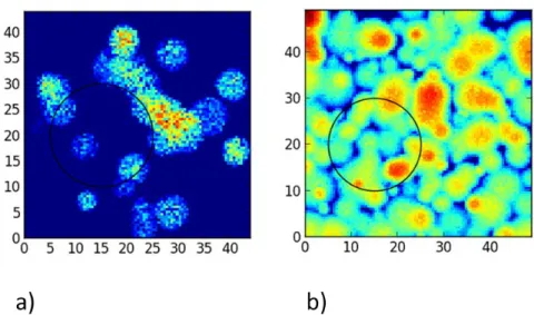
The study presented here relies on numerical modelling and simulations. LIDAR data simulations were generated thanks to the radiative transfer model DART [1] for defined reference scenes. Four scenes of interest were studied to cover the two parameters: tree height and canopy density (high/dense, high/sparse, low/dense and low/sparse) (see Figure 1). For each scene, DART provided simulated full-waveforms for a 20 meter diameter spot suitable for forest applications. The low energy approach induces a low level of return signal from the scene, imposing to accumulate successive shot returns. We chose to set an accumulation of 14 successive shots as a baseline to derive the instrument performance. At the considered PRF, the spots move on the ground by 10 m over the corresponding duration. Therefore not only one waveform but a set of waveforms taking into account the displacement of the spot on ground has been provided. Note that each reference scene has been simulated at four wavelengths from UV to IR (0.355 µm, 0.532 µm, 1.06 µm and 1.55 µm).
From the waveforms it was then possible to generate discrete statistically representative low flux events detected by the instrument. Indeed, operating the laser at low energy leads to work with low return flux from the scene (in photon counting regime). The arrival of the incoming photons to the instrument follows the Poisson statistical law. From these discrete pseudo-waveforms one could extract the time duration between the top of canopy echo and the ground echo and derive the tree height in consequence. It is important to note that the data processing algorithm enabling to derive canopy height from the return signal contributes to a large extent to the altimetry accuracy. If future investigations were to be led, this processing aspect should be further addressed. In this study, for the purpose of simplicity of both implementation and interpretation, canopy height was defined based on the cumulated energy of accumulated return signals, with thresholds set to 3% and 97% for canopy top and ground, respectively.
In order to explore the sensitivity of the instrument performance with respect to the signal-to-noise ratio, the link budget was scaled based on the LIDAR product quantity (product of the laser emitted energy and of the instrument collecting surface). The science team had set a preliminary specification on the instrument measurement error to 2 m. By sweeping the lidar product value, we could determine the minimum link budget to meet the error specification.
A first conclusion drawn from these simulations is that the near IR and IR wavelengths are the most suited for the forest mission in the explored wavelength range. The UV and green wavelengths provide degraded performances with respect to NIR and IR. This can be related to the lower albedos of both leaves and ground for the reference scenes. In addition, two reference scenes were not considered for the instrument sizing because the accuracy on the tree height was too poor. The degraded accuracy on these scenes is linked to a vegetation either too sparse (15 % vegetation coverage) or with maximum canopy height too low (4 m).
Therefore the threshold link budget to meet the measurement error specification has been derived at 1.064 µm and 1.55 µm on two reference scenes (high trees for dense and sparse canopies) which were representative of one tropical forest and one temperate forest type, a mangrove and a maritime pine plantation. The tropical scene is driving the design as tropical forests store about 40% of the forest biomass. The resulting proposed design consists of a telescope of 0.8 m diameter and a laser with an energy per shot of 200 µJ at the PRF of 10 KHz. Such characteristics result in an instrument with mass and electrical power consumption budgets of 220 kg and 240 W.
Technical review
In parallel a technical review of both detection subsystem and laser sources was led to identify potential suitable technologies for the mission in both domains. Avalanche photodiodes operated in linear regime despite their moderate maturity appear to be the best candidate for such mission. Such detectors indeed combine high detection efficiency and very low dead time after detection. On the source side, several options exist although the most mature remains the MOPA architecture already chosen for the in-orbit LIDAR missions. The forest spectral response imposes that the LIDAR works in SWIR band. Current common lasers operate at 1.06µm and 1.55µm without any conversion. The better wall-plug efficiency for Nd:YAG at 1.06µm leads us to favour this wavelength over 1.55µm.
Conclusion
This study demonstrates that the use of high frequency and low energy LIDARs for measuring tree height is achievable with a reasonable design and interface budgets compatible with space missions. While maintaining good performances with respect to higher energy LIDARs, operating at low energy enables to greatly reduce the laser induced risks (e.g. LID, LIC, eye safety) which are a major concern for LIDAR space missions. In addition such operating point provides continuous measurements on ground offering more freedom in the data processing and enabling to reduce the altimetry uncertainties on sloped areas.
Acknowledgement
Airbus Defence and Space would like to thank CNES for funding this study and also thanks Christophe Proisy from IRD for providing the mangrove scene.
Figure 1: View of two simulated scenes (50m x 50m). The black circle shows the dimension of the LIDAR spot on-ground. A) Landes scenes: high trees, low canopy density. B) Tropical scene: high trees, high canopy
density.
References
[1] Grau, E. and Gastellu-Etchegrry, J.P. (2012). Radiative transfer modeling in the Earth Atmosphere system with DART model. Remote Sensing of the Environment, 139, 149-170