HAL Id: hal-01901914
https://hal.univ-brest.fr/hal-01901914
Submitted on 10 Dec 2018HAL is a multi-disciplinary open access archive for the deposit and dissemination of sci-entific research documents, whether they are pub-lished or not. The documents may come from teaching and research institutions in France or abroad, or from public or private research centers.
L’archive ouverte pluridisciplinaire HAL, est destinée au dépôt et à la diffusion de documents scientifiques de niveau recherche, publiés ou non, émanant des établissements d’enseignement et de recherche français ou étrangers, des laboratoires publics ou privés.
Nubia–Somalia southern plate boundary
Eric Deville, Tania Marsset, Simon Courgeon, Romain Jatiault, Jean-Pierre
Ponte, Estelle Thereau, Gwenael Jouet, Stéphan Jorry, Laurence Droz
To cite this version:
Eric Deville, Tania Marsset, Simon Courgeon, Romain Jatiault, Jean-Pierre Ponte, et al.. Active fault system across the oceanic lithosphere of the Mozambique Channel: Implications for the Nubia– Somalia southern plate boundary. Earth and Planetary Science Letters, Elsevier, 2018, 502, pp.210-220. �10.1016/j.epsl.2018.08.052�. �hal-01901914�
1
Active fault system across the oceanic lithosphere of the Mozambique Channel: 1
Implications for the Nubia-Somalia southern plate boundary 2
3
Eric Devillea*, Tania Marssetb, Simon Courgeonb,c, Romain Jatiaultd,e, Jean-Pierre Pontef,
4
Estelle Thereaub, Gwenael Jouetb, Stéphan J. Jorryb, Laurence Drozg
5 6
aIFPEN-IFP School, 1-4 avenue de Bois-Préau, 92852 Rueil-Malmaison, France
7
bIFREMER, Unité Géosciences Marines, 29280 Plouzané, France
8
cUniversity of Geneva, Departement of Earth Sciences, Rue des Maraichers 13, CH-1205 Geneva, Switzerland
9
dTOTAL, Exploration and Production, CSTJF, Avenue Larribau, 64000 Pau, France
10
eCNRS, Laboratoire CEFREM, Avenue Paul Alduy, 66000 Perpignan, France
11
fUniversité de Rennes 1, campus Beaulieu OSUR, 35042 Rennes cedex, France
12
Université de Bretagne occidentale, IUEM, 29280 Plouzané, France
13 14
ABSTRACT 15
16
Seismic reflection and multibeam echosounder data were acquired in the Mozambique Channel in 17
2014 and 2015 during the PTOLEMEE, PAMELA-MOZ02 and -MOZ04 marine surveys aboard the 18
RV Atalante and Pourquoi Pas? These data revealed that an active fault system is deforming the 19
oceanic lithosphere of the Mozambique Basin which has developed during Jurassic-Cretaceous times. 20
The correlation between the fault system and the arrangement of earthquake epicenters suggests that 21
this tectonically active zone directly connects northward with the southern part of the eastern branch of 22
the East African Rift System which corresponds to the seismically active graben system bounding the 23
northern part of the Davie ridge. The fault zone extends southwestward of the Mozambique Ridge 24
along the same trend as the Agulhas-Falkland transform fault zone. The general organization of the 25
fault zone shows the characteristics of an extensional system north of the Mozambique Channel (north 26
of the Europa Island) and a right-lateral transtensional system with coeval normal faults and strike-slip 27
2
faults south-west of Europa. This tectonic activity is associated with volcanic activity since at least 28
Late Miocene times. Our findings emphasize that the eastern branch of East African Rift System is 29
extending largely toward the south, not only in continental domains but also through the oceanic 30
lithosphere of the Mozambique basin. This fault zone is participating to the complex plate boundary 31
between the main African continent (Nubia Plate) and Madagascar (Somalia Plate). 32
33
Keywords: Active faults, Mozambique Channel, plate boundary, Nubia plate, Somalia plate
34 35
* Corresponding author 36
3 37
1. Introduction 38
39
The East African Rift System (EARS), originally described by Suess (1891), corresponds 40
to the northern part of the divergent plate boundary system between the Nubian (West 41
African) and Somali (East African) plates. This rift system is connected northward to the Afar 42
hot spot which is related to the opening of the Red Sea and the Gulf of Aden, which began 43
being active about 30 Ma ago. However, it is considered that the EARS began to be active 44
only later, starting 24 Ma ago in the Afar area (Chorowicz, 2005). Although the EARS is 45
commonly considered as the modern archetype of rifted plate boundaries, the current Nubia-46
Somalia kinematics is among the least well-known of all the major plate boundaries (Calais et 47
al., 2006; Stamps et al., 2008). The plate boundary between Nubia and Somalia developed 48
over thousands of kilometers across the eastern part of Africa during Late Oligocene and 49
Neogene times (Chorowicz, 2005; Ebinger, 2012; McGregor, 2015). The location of the plate 50
boundaries is well-defined along the continental branches of the EARS which include a 51
western branch and an eastern branch (Fig. 1). The eastern branch (Gregory Rift) is 52
characterized by high volcanic activity (including Mount Kilimanjaro, the highest point of 53
Africa) and the western branch (Albertine Rift) is characterized by a moderate volcanic 54
activity relative to the eastern branch and by deeper basins, containing lakes and sediments. 55
The Great Lakes (Albert, Tanganyika, Rukwa, Malawi) are located in highly rifted basins 56
bounded by normal and strike-slip faults of the western branch of the EARS. The two 57
branches of the EARS delineate major relatively poorly deformed blocks: Victoria and 58
Rovuma (Hartnady, 2002; Calais et al., 2006; Stamps et al., 2008, 2014; Fernandes et al., 59
2013; Saria et al., 2014; Fig. 1). The eastern branch of the EARS extends off Tanzania and in 60
the northern part of the Mozambique offshore, bounding notably the Davie Ridge (Mougenot 61
4
et al., 2005; Mahanjane et al., 2014 a & b; Franke et al., 2015; Mulibo and Nyblade, 2015). 62
But south of the Davie Ridge in the eastern branch and south of the Machaze epicentral area 63
in the western branch (Fig. 1 & 2), the exact location of the EARS still remains a topic of 64
discussion. Scattered extensional structures associated with seismic activity are found onshore 65
in Mozambique, Swaziland and South Africa (Foster and Jackson, 1998; Yang and Chen, 66
2010; Fonseca et al., 2014; Domingues et al., 2016) and also along the Comores and Mayotte 67
islands and within Madagascar (Grinison and Chen, 1988; Bertil and Regnoult, 1998; Kusky 68
et al., 2007, 2010; Michon, 2016; Fig. 1). Active tectonics across Madagascar has been 69
interpreted as a possible extension connected to the East African Rift System (Kusky et al., 70
2007; 2010). It forms a segment running through Comores, across Madagascar and finally 71
extends to the Southwest Indian spreading ridge. This extension is associated to Neogene-72
Quaternary alkaline volcanic activity associated with active hot springs. It also causes high 73
and young topography and seismic activity and it is probably associated to mantle rise under 74
Madagascar (Kusky et al., 2010). Earthquakes have also been recorded within the 75
Mozambique Channel (Hartnady, 2002; Stamp et al., 2008) but prior to this study no data 76
were available to characterize structural evidence for recent to active deformation within the 77
Mozambique Channel (Fig. 1). Marine geophysical surveys carried out in 2014 and 2015 78
provided evidence for a recent/active fault system running crossing the Mozambique Basin 79
(Fig. 4). This paper aims providing an analysis of the spatial distribution of active faults as 80
well as faults sealed by recent sediments within this area. We notably present some examples 81
of bathymetric data and seismic lines showing these structures and we discuss the significance 82
of this fault system in the plate tectonics framework of the East African offshore. 83
84
2. Geodynamic and geological framework 85
5
North of the Mozambique Channel, the southern extension of the eastern branch of the 87
EARS off Tanzania and Mozambique (eastern boundary of the Rovuma block) has been well-88
established by seismic reflection data (Mougenot et al., 1986; Mahanjane, 2014a; Franke et 89
al., 2015), earthquake slip vector data and GPS data (Calais et al., 2006; Stamps et al., 2008; 90
Saria et al., 2014), and spatial distribution of earthquake focal mechanisms (Grimison and 91
Chen, 1988; Yang and Chen, 2010; Delvaux and Barth, 2010; Franke et al., 2015). The 92
offshore segment of the eastern branch of the EARS is characterized from north to south by 93
Neogene extension tectonics overimposed on former strike–slip structures of the Tanzanian-94
northern Mozambique transform margin which have developed during Mid Jurassic-95
Cretaceous times in relation with the drift of Madagascar with respect to Africa (Rabinowitz 96
et al., 1983; Coffin and Rabinowitz, 1987; Storey et al., 1995; Reeves, 2014; Franke et al., 97
2015). Regarding the current kinematics of the plate boundary between Nubia and Somalia, 98
Chu and Gordon (1999) analysis placed the pole of rotation of Nubia versus Somalia in the 99
offshore of southeastern cost of South African, in the Mozambique Ridge or south of the 100
Mozambique basin (Fig. 1), which imply that south of the rotation pole, the southern part of 101
the Nubian-Somali plate boundary is a diffuse zone of convergence (up to ~2mm yr-1). This
102
interpretation is consistent with subsequent work integrating seismicity studies (Horner-103
Johnson et al., 2007) and coupled seismicity-GPS studies (Calais et al., 2006; Stamps et al., 104
2008; Argus et al., 2010; DeMets et al., 2010; Saria et al., 2014; Stamps et al., 2014; Fig. 1). 105
Clusters of earthquake epicenters are located in continental Africa (Fonseca et al., 2014). In 106
addition, evidence for volcanism and tectonic activity characterized by earthquakes has been 107
reported along faults in the Comoros and Mayotte (Emerick and Duncan, 1982; Michon, 108
2016) and Madagascar (Kusky et al., 2007; 2010). This seismic activity shows that the 109
deformation between the Nubian and Somali plates is distributed over a wide area, in several 110
segments. In this complex tectonic setting, the exact location and the processes of deformation 111
6
related to plate tectonics movements in the area of the Mozambique Channel remain poorly 112
understood. West of the Mozambique Channel, surface structural evidence for rifting appears 113
to stop around 22°S, south of the Lake Malawi and the Inhaminga fault, in the Machaze 114
epicentral area (Fig. 1), whereas seismic activity at depth extend farther to the south in 115
Swaziland and South Africa (Fonseca et al., 2014). On the other hand, east of the 116
Mozambique Channel, the presence of active volcanism, recent faults, and seismic activity 117
suggest that active deformation running through wide parts of Madagascar might correspond 118
to the western boundary of the Somali plate (Kusky et al., 2007, 2010; Stamps et al., 2008; 119
Saria et al., 2013). Several authors have proposed the presence of a dominantly oceanic 120
Lwandle block (name derived from the Xhosa word for ocean) extending south of the 121
Rovuma block in the Mozambique Channel between southern Mozambique and Madagascar 122
(Hartnady, 2002 ; Horner-Johnson et al., 2007 ; Stamps et al., 2008, 2018; Saria et al., 2014). 123
The dimension and precise boundaries of this block are very poorly constrained at this stage. 124
Kinematic models proposed by Stamps et al. (2008) and Saria et al. (2014) invoke a possible 125
extensive/transform zone in the Mozambique channel distributed along a NE-SW trend 126
crossing the channel (Figs. 1 and 2). Between Africa and Madagascar, the deep water area of 127
the Mozambique basin is characterized by the development of an oceanic lithosphere which 128
began to develop during the Mid Jurassic-Cretaceous drift of Antarctica with respect to Africa 129
(Rabinowitz et al., 1983; Coffin and Rabinowitz, 1988). The oceanic domain of the 130
Mozambique basin is largely invaded by sediments forming the turbidite system connected to 131
the sediment supply coming from the Zambezi River (Walford et al., 2005). The main channel 132
of this turbidite system shows locally strong evidence of erosion (Kolla et al., 1991). The 133
Mozambique Channel is also characterized by the presence of the Davie ridge which runs 134
NNW-SSE west of Madagascar and which delimits the eastern part the oceanic domain of the 135
Mozambique Channel. It corresponds to the extinct transform fault system along which 136
7
Madagascar separated from the future Somali plate between 160–115 Ma ago. Dredge 137
samples collected along the Davie Ridge show that isolated blocks of Precambrian basement 138
and volcanics are preserved along this paleo-transform ridge. These volcanics include Late 139
Cretaceous and Cenozoic lava flows (De Wit, 2003; Courgeon et al., 2016, 2017). The 140
oceanic domain of the Mozambique Channel is also the site of volcanic edifices forming 141
seamounts covered by Neogene carbonate deposits forming locally modern reefs and emerged 142
lands at Bassas da India and Europa (Jorry et al., 2016; Courgeon et al., 2016, 2017). The 143
average elevation of the Mozambique basin is anomalously high with respect to its age even 144
taking into account the sedimentary and volcanic input (Castelino et al., 2016) and this 145
anomalously shallow area extends largely southwesterly to the southwest offshore of South 146
Africa (Nyblade and Robinson, 1994). This topographic anomaly, as well as the significance 147
of the volcanism discovered in this area remained both largely unexplained before this study. 148
149
3. Methodology 150
151
In this paper, we present seismic reflection data coupled with multibeam echosounder 152
acquisitions. Geophysical data were acquired in the Mozambique Channel in 2014 and 2015 153
during the PTOLEMEE (Jorry, 2014), PAMELA-MOZ02 (Robin and Droz, 2014) and 154
PAMELA-MOZ04 (Jouet and Deville, 2015) marine surveys aboard the RV L’Atalante and 155
Pourquoi Pas? The seismic source used for the seismic acquisitions was 2 GI air guns
156
(105/105 ci, 45/45 ci). The streamer had 48 seismic traces with inter-traces of 6.25 m and 4 157
hydrophones SFH with a spacing of 0.78 m per trace. The total length of the streamer was 158
531.6 m. Acquisition time was 9 seconds and the sampling frequency was 1 kHz. The seismic 159
acquisition system was a SEAL 428, V1.1 Patch 23. Seismic data were processed using 160
Ifremer QC-Sispeed software and integrated in Kingdom Suite software for the interpretation 161
of seismic profiles. A map of the fault zone was produced (Fig. 2), encompassing the spatial 162
8
distribution of active faults (i.e. faults expressed up to the seafloor) and sealed faults (i.e. 163
faults covered by sediments). Bathymetric data were acquired using the multibeam 164
echosounders Kongsberg EM122 (Frequency of 12 kHz) and EM710 (Frequency bandwidth 165
of 71-100 kHz). The data were processed using Ifremer Caraïbes software and integrated in 166
ArcGissoftware for morphobathymetric analysis of seafloor features. The map of the fault 167
zone based on seismic data was compared with morphobathymetric analysis. 168
In order to provide a reliable mapping of the fault zone, we compared the morphologic 169
features visible on bathymetric data and the visible structures on the seismic lines (Fig. 3), in 170
order to distinguish notably linear sedimentary features (e.g. dunes crests) and structural 171
lineaments (active faults; Fig. 3). The map of fault zone was completed for active faults 172
whose linear extent and orientation are visible on the bathymetric profiles (Fig. 3). 173
174
4. Results and interpretation 175
176
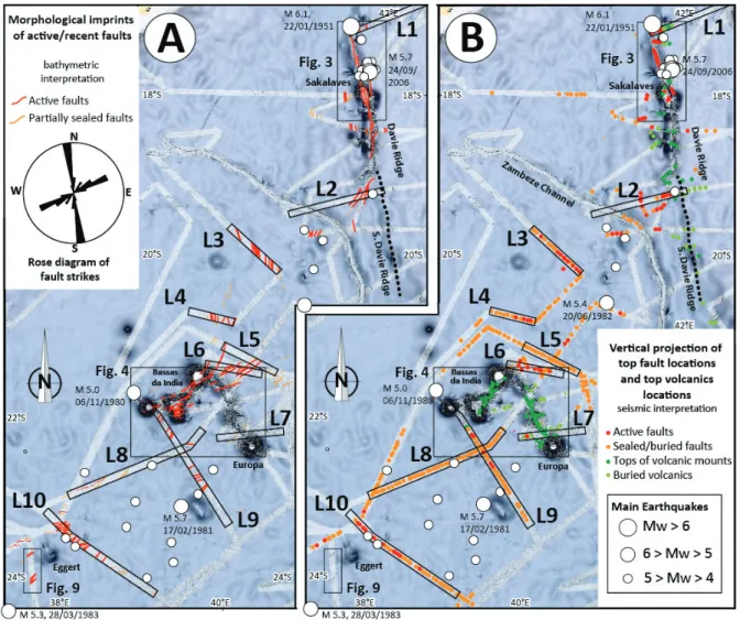
4.1 Spatial distribution of the faults
177 178
Several seismic profiles, especially around the Bassas da India and Europa islands, show the 179
presence of a wide system of faults (Fig. 2, 3). Some of the most characteristic lines 180
illustrating this fault system are presented in figure 4, 5, 6, and 7. The penetration in the 181
sediments is slightly than 1.5 s TWT (Two Way Travel time) and deepest observations reach 182
5.5 s TWT. 183
The results of the bathymetry-seismic reflection correlation are synthetized in Fig. 3 and 184
examples of the most characteristic bathymetric data showing morphologic expressions at the 185
seabedrelated to fault activity are shown along seismic lines of the Fig. 5 and 6. The 186
comparison between the morphological features visible on bathymetric data and the structures 187
9
visible on the seismic lines shows a good fit concerning the location of the fault system (Fig. 188
2, 5, 6). It also allows estimating the main strikes of the faults which is not possible with the 189
seismic data alone because the density of the available seismic data does not allow 190
correlating faults from one line to another. This combined approach using bathymetry and 191
seismic data allows defining the main fracturing zones within the Mozambique Channel. This 192
work shows that between latitudes 18°S and 20°S, the fault zone merges with the active fault 193
system adjacent to the northern part of the Davie Ridge which has been described in recent 194
papers (Mahanjane, 2014; Franke et al., 2015; Fig. 3), including notably, N-S trending faults 195
found along the Sakalaves Mounts (Courgeon et al., 2018; Fig. 3). From the Davie ridge, the 196
fault zone develops to the southwest across the Mozambique Channel. This fault zone, more 197
than 200 km-wide, crosses the seamounts of Europa, Bassas da India, and Hall bank (Fig. 2, 198
4) and joins the northern part of the Mozambique Ridge to the southwest. Two main trends of 199
fault strikes have been observed, one trending N160-180°, the other N45-80° (Fig. 2). This 200
confirms the results of a recent study of the Mounts Sakalaves and the Bassas de India-Jaguar-201
Hall banks, which showed the existence of faults trending NE-SW that can be tracked on 202
bathymetric data affecting the carbonates of the seamounts, some of these faults being 203
associated with volcanic activity (Courgeon et al., 2016, 2017; Fig. 4). In the vicinity of the 204
seamounts which include volcanic edifices, acoustic masks prevent these faults from being 205
imaged under volcanic rocks (probably related to the contrast of the high seismic velocity of 206
the volcanics compared to the seismic velocity of the sediments around; Fig. 7) but apart from 207
seamounts, faults are clearly visible on the seismic reflection lines. The fault system is 208
trending toward the southwest of the Mozambique Basin as a continuation of the Agulhas 209
major fracture zone (Fig. 1), which extends largely westward along the Falkland fault zone in 210
Southern Atlantic. 211
10
On some of the seismic lines considered approximately perpendicular to the strike of the 212
faults, depth-conversion with an average velocity of 2000 m/s (mean velocity deduced from 213
refraction studies and ODP drilling in the area, ODP leg 25, wells 242, 248, 250; see 214
Supplementary Material, Figs. S2 and S3) shows that most of these faults, north of the Europa 215
island, correspond to normal faults. Indeed, these faults have apparent conjugated dips 216
showing absolute values between 50° and 70° (Fig. 4, 5, 6, i.e. compatible with conjugated 217
normal faults). In the south of Europa Island, to the southwest, the faults tend to be steeper 218
and many of them are almost vertical (Fig. 7). As such, the fault system of this SW area is 219
different from the characteristic conjugated systems of normal faults present in the northern 220
part of the Mozambique Channel and the presence of nearly vertical faults suggests a strike-221
slip activity. In addition, well-expressed and localized depressions forming traps for the 222
sediments of the Mozambique turbidite system may correspond to pull-apart basins associated 223
with strike-slip activity. This interpretation is consistent with the fact that some border faults 224
systems of these depressions show clear evidence for the development of en-échelons systems 225
of faults probably related to right lateral strike-slip component (Fig. 9). The general 226
characteristics of the fault geometries in the southwestern part of the Mozambique Channel 227
can be regarded as related to transtensional structures. 228
The most recent faults affect all sedimentary series down to the penetration window and 229
are well-expressed in the seabed topography with fault scarps up to 50 ms TWT visible on 230
both the seismic lines and multibeam data. It is therefore likely that these faults were active 231
during Quaternary times and some of them are probably active and contemporaneous with the 232
most recent volcanism events. The fault zone described here is indeed still partly active as 233
shown by the seismicity data in the Europa and Bassas da India area (Fig. 1; see discussion 234
below). The profile L4 in figure 6 shows a major syn-sedimentary fault with very high 235
amplitude reflectors in the shallow layers. The syn-tectonic character of this fault is 236
11
demonstrated by the presence of syn-tectonic pinch-out clearly visible on the seismic line 237
(Fig. 6). This fault, well-expressed in the topography of the sea bottom, is probably an active 238
fault. Throughout the study area, the major faults affect the sedimentary series down to the 239
penetration limit of the seismic data. 240
In addition to the faults that affect the uppermost sedimentary series many faults do not 241
reach the seabed. The interpretation of the timing of activity of these buried faults is 242
questionable. They can either correspond to sealed faults which were active in the past and 243
then became inactive after or, depending on the rheological properties of the sedimentary 244
series, some faults may be expressed at depth (brittle deformation), while deformation is 245
accommodated by continuous creeping in shallower layers. The observed offsets of the sealed 246
faults seem to be lower than the one of the active faults (maximum ~ 30 ms TWT, ~ 20 m) but 247
these faults are much more numerous than the recent faults (Fig. 5, 6, 7). This suggests that 248
early deformation was more diffuse and widely distributed and that, overtime, deformation 249
tended to be more localized. Some of these faults are hardly detectable (if at all) in a poorly 250
reflective interval (Fig. 5, 6, 7). This could be related to the rheological properties of these 251
levels which can correspond to relatively plastic clays-rich horizons. On the other hand, many 252
faults are sealed by the uppermost sedimentary series and partly by volcanic flows (Fig. 5, 6, 253
7). 254 255
4.2 Chronostratigraphic framework of fault activity
256 257
The picking of these faults shows that they are not always sealed at the same level but, 258
depending of the cases, the throw of the fault stops at different stratigraphic layers (Fig. 4). In 259
addition, in some cases, the values of the fault throw are higher at depth with some values 260
above 100 ms TWT. This suggests a relatively long duration of fault activity (since the 261
12
Miocene). It is worth noting that sealed faults are also observed on the inactive part of the 262
Davie Ridge (southernmost area of this ridge) as evidenced by the draping of faults by the 263
sediments (Fig. 5). 264
In order to propose a timing of the beginning of the fault activities, we picked some 265
characteristic horizons which are interpreted as time lines (Fig. 4, 5, 6, 7). The ages proposed 266
for these horizons are consistent with the interpretations of Franke et al. (2015) in the northern 267
part of the Mozambique Channel and Mahanjane et al. (2014b) and Ponte (2018) from well 268
calibration located on Zambezi platform (yellow marker: near top Miocene, orange marker: 269
near top Oligocene, red marker: near top Eocene). According to this interpretation, it appears 270
that all the faults affect Miocene and older sediments but some being sealed at the top of the 271
Miocene whereas, as mentioned previously, others affect the whole stratigraphic series up to 272
the sea-bottom. Accordingly, we deduced that the global period of faulting lasted from late 273 Miocene to present-day. 274 275 5. Discussion 276 277
5.1. Structural trends within the fault zone
278 279
Between the Davie Ridge and the Mozambique Ridge, the fault system developed within the 280
oceanic lithosphere of the Mozambique Basin (see Fig. 10, with location of the oceanic crust 281
from Konig and Jokat, 2010; Leinweber and Jokat, 2012; Davis et al., 2016; Mueller and 282
Jokat, 2017). In this area, the tectonic style is different from the dominant one north of 20°S 283
which corresponds to rift-related structures including the tilt of wide continental crustal 284
blocks (Franke et al., 2015). South of 20°S, the fault zone forms a wide area (> 200 km wide) 285
characterized by a diffuse deformation made of a relatively dense system of faults with 286
13
moderate throws. These faults are mostly straight (planar), whereas the main faults are mainly 287
listric north of 20°S (Franke et al., 2015). This may be due to the fact that the oceanic 288
lithosphere does not includes decoupling layers like the lower thick continental crust, the 289
faults being here rooted deeply within the oceanic lithosphere. 290
Within this fault zone affecting the oceanic lithosphere of the Mozambique Basin, two main 291
strikes of fault were observed, N160-180° and NE-SW. The N160-180° trends are 292
predominant in the northern area (north of Bassas da India), while fault trends from the 293
southern area are mostly oriented NE-SW. These different trends are possibly controlled by 294
inherited fracture zones within the oceanic lithosphere, the N160-180° trends being probably 295
controlled mainly by transform fracture zones parallel to the Davie Ridge transform system 296
(Fig. 10), and the NE-SW trends being possibly influenced by fractures which are parallel to 297
the magnetic anomalies of the oceanic crust (normal faults from the oceanic accretion period; 298
Fig. 10). 299
300
5.2. Active earthquakes along the fault zone
301 302
A correlation exists between the area of recent faulting evidenced within the Pliocene-303
Quaternary sediments and the location of the earthquakes (Fig. 10). Indeed, the most 304
significant earthquakes (Mw > 4) recorded within the Mozambique Channel are trending 305
mostly along the zones where the faults described in this paper are reaching the sea floor (Fig. 306
2). Only a few isolated and relatively shallow earthquakes (focal depths < 25 km) occurred 307
south of this fault zone in the deep water part of the Mozambique Basin south of 26°S (Fig. 308
10, see also supplementary material Fig. S1, Table S1). These isolated earthquakes show focal 309
mechanisms consistent with a NW-SE extension (Fig. 10), while earthquake focal 310
mechanisms north of Mozambique Channel along the Davie Ridge are consistent with 311
14
roughly a E-W extension with focal depths mostly shallower than 25 km, some being between 312
25 km and 50 km (Foster and Jackson, 1998; Yang and Chen, 2010; Saria et al., 2014; Fig. 2, 313
3). The 4 larger earthquakes (Mw 5.0 to 5.7) over the last 50 years were recorded between 314
1980 and 1983, in the Europa/Bassas da India region. In 1951 and 1950, earthquake 315
magnitudes reached Mw 6.1 and 6.2 in the area of the Davie Ridge (Fig. 2). South of 20°S, 316
the Davie Ridge is mostly tectonically inactive (no recorded earthquake > Mw 3 and no 317
evidence of recent tectonics on the seismic lines as shown by the fault sealing of the Ridge; 318
Fig. 2). As mentioned above, to the southwest, the studied active fault zone seems to be 319
aligned with Agulhas-Falkland fault zone where important earthquakes have been mentioned, 320
notably one Mw 6.8 located offshore of Durban in the Natal valley (point A in Fig. 1), which 321
occurred December 31st, 1932 (focal depth 15 km). This area of the Natal valley is possibly
322
associated with volcanic seamounts which might be related to the EARS extension tectonics 323
(Wiles et al., 2014). The active fault system described in this paper which is associated to 324
seismic activity is clearly distinct from the deformation trend onshore Mozambique which is 325
associated to seismic activity characterizing an E-W extension or local strike-slip movements 326
(Fig. 10). It is also clearly distinct from the deformation processes recorded within 327
Madagascar which are associated to scattered earthquakes some of them being compressional 328
(Fig. 10). 329
330
5.3. Fault zone and volcanism
331 332
As described in previous works, the carbonate seamounts of the Mozambique Channel 333
have developed either on crystalline basement rocks or on volcanic systems (Bassias, 1992; 334
Courgeon et al., 2016, 2017). Faults are expressed at the seabed even in the most recent 335
carbonate deposits covering the volcanic edifices (Figs. 4 and 7). The main volcanic edifices 336
15
trending along the fault zone described in this work were most likely developed during Mid-337
Miocene but volcanism went on to be active until very recent times forming dykes and lava 338
flows visible at the sea bottom (Courgeon et al., 2016, 2017). The acoustic masks below the 339
volcanics around Bassas da India, Europa Islands and Hall Bank being located along the fault 340
zone, we can assume that the volcanic mounts are rooted on deep faults that cannot be imaged 341
from the seismic data because of the acoustic mask under the volcanics. In the peripheral 342
areas of the Mozambique Channel, the end of the Miocene corresponds to a period of 343
significant volcanism, probably the major episode in the region (Roberts et al., 2012). 344
Therefore, some of the faults were probably already active as soon as Miocene times which is 345
consistent with the tectonic framework of the EARS (Chorowicz, 2005; McGregor, 2015). 346
347
5.4. Significance of the fault zone in the framework of plate tectonics
348 349
In terms of global plate tectonics and location of deformation zones between the Nubian 350
and Somali plates, this study shows that one of the branches of this complex plate boundary 351
(the eastern branch of the EARS) can be followed at least as south as 25°S trending toward 352
the area where most of the kinematic studies locate the pole of rotation between Nubia and 353
Somalia plates (see discussion above § 2; Fig. 1). As such, this study shows that the eastern 354
branch of the East African Rift System is extending much further south than previously 355
demonstrated with facts, not only in continental domains but also across the oceanic 356
lithosphere of the Mozambique basin. As it is the case along the eastern branch of the EARS 357
north of the studied area (Mulibo and Nyblade, 2013), the zone of lithospheric divergence 358
presented in this paper, with a transform component toward the south, is probably responsible 359
for the thinning and the rise of the mantle below which may be the cause of partial melting in 360
the mantle sourcing the volcanic systems associated with the fault zone. This oceanic mantle 361
16
rise is also probably responsible for the regional uplift linked with the anomalously high 362
topography of the northern part of the Mozambique basin mentioned previously. 363
364
6. Conclusion 365
366
This study has shown that the eastern branch of the EARS extends offshore across the 367
Mozambique Channel from the Davie Ridge to the Mozambique Ridge, where it is 368
characterized by a zone of densely distributed faults, trending NNE-SSW and deforming the 369
oceanic lithosphere of the Mozambique channel that developed much earlier, during Jurassic-370
Cretaceous times. The fault zone is well characterized within the sediments of the 371
Mozambique basin and shows that faults have been active since at least the Miocene times 372
and some of them are still seismically active (Fig. 10). Earthquakes with magnitude reaching 373
Mw 6.1 around the Davie Ridge and Mw 5.7 around the Europa-Bassas da India Islands 374
occurred along the fault zone during the last decades. The focal depths of the earthquakes are 375
deeper than the sedimentary accumulations, probably within the mantle of the oceanic 376
lithosphere of the Mozambique Basin. The fault zone structure is compatible with a purely 377
extensional deformation around the Davie Ridge and a dextral transtensional system between 378
the Davie Ridge and the Mozambique Ridge. This interpretation is also compatible with 379
earthquake focal mechanisms (Fig. 10) and recently published kinematic models (Stamps et 380
al., 2008; 2014, 2018; Saria et al., 2014). The fault zone activity is associated with volcanic 381
activity controlling the development of the seamounts present within the Mozambique 382
Channel. This active extensional process taking part of the EARS is probably associated with 383
mantle rise that might be responsible for the anomalously high topography of the northern 384
part of the Mozambique basin due to the presence of relatively hot rising mantle at depth. 385
With active deformation onshore Africa, notably along the Inhaminga fault zone, and also 386
17
along the Comoros-Mayotte and Madagascar system, the active fault zone of the Mozambique 387
Channel is participating to the complex plate boundary between the African main continent 388
(Nubia Plate) and Madagascar (Somalia Plate). 389
390
Acknowledgements 391
392
This work has been conducted within the framework of the PAMELA (PAssive Margin 393
Exploration LAboratories) project leaded by IFREMER and TOTAL in collaboration with 394
Université de Bretagne Occidentale, Université de Rennes 1, Université Pierre et Marie Curie 395
Paris 6, CNRS and IFP Energies Nouvelles. Data acquisition was made in 2014 during the 396
PTOLEMEE (Jorry, 2014), and PAMELA-MOZ02 (Robin and Droz, 2014) marine surveys 397
onboard the R/V L’Atalante and in 2015 during the PAMELA-MOZ04 survey (Jouet and 398
Deville, 2015) onboard the R/V Pourquoi Pas? We thank captains, officers, crew members 399
and scientific teams of the PTOLEMEE, PAMELA-MOZ2 and PAMELA-MOZ4 cruises for 400
their technical support in recovering dataset. Yannick Thomas and Pauline Dupont from 401
Ifremer are acknowledged for their contribution in the processing of the seismic lines. 402
403 404
Appendix A. Supplementary data 405
406
Supplementary data to this article can be found at http://www.seanoe.org/data/00445/55634/ 407
(Licence: Creative Commons Attribution, no commercial usage, sharing under the same 408
conditions). 409
410 411
18 References
412 413
Altamimi, Z., Métivier, L., Collilieux, X., 2012. ITRF2008 plate motion model, J. Geophys. 414
Res., 117, B07402, doi:10.1029/2011JB008930. 415
Argus, D. F., R. G. Gordon, M. B. Heflin, C. Ma, R. Eanes, P. Willis, W. R. Peltier, and S. 416
Owen (2010), The angular velocities of the plates and the velocity of Earth’s center from 417
space geodesy, Geophys. J. Int., 180(3), 916–960, doi:10.1111/j.1365-246X.2009.04463.x. 418
Bassias, Y., 1992. Petrological and geochemical investigation of rocks from the Davie 419
fracture zone (Mozambique Channel) and some tectonic implications, J. Afr. Earth Sci. 420
(Middle East), 15(3–4), 321–339. 421
Bertil, D., Regnoult, J.M., 1998. Seismotectonics of Madagascar. Tectonophysics 294, 57-74. 422
Calais, E., Hartnady, C., Ebinger, C., Nocquet, J. M., 2006. Kinematics of the East African 423
Rift from GPS and earthquake slip vector data, in Structure and Evolution of the Rift 424
Systems Within the Afar Volcanic Province, Northeast Africa, Geol. Soc. London Spec. 425
Publ., vol. 259, edited by G. Yirgu, C. J. Ebinger, and P. K. H. Maguire, 9–22. 426
Castelino, J.A., Eagles, G., Jokat, W., 2016. Anomalous bathymetry and palaeobathymetric 427
models of the Mozambique Basin and Riiser Larsen Sea. Earth and Planetary Science 428
Letters 455, 25-37. 429
Chorowicz, J., 2005. The East African rift system. Journal of African Earth Sciences 43(1–3), 430
379–410. 431
Chu, D., Gordon, R.G., 1999. Evidence for motion between Nubia and Somalia along the 432
Southwest Indian Ridge, Nature, 398, 64– 67. 433
Coffin, M. F., Rabinowitz, P.D., 1987. Reconstruction of Madagascar and Africa: Evidence 434
from the Davie Fracture Zone and Western Somali Basin, J. Geophys. Res., 92(B9), 9385– 435
9406, doi:10.1029/JB092iB09p09385. 436
19
Courgeon S., Jorry, S.J., Camoin, G.F., BouDagher-Fadel, M.K., Jouet G., Révillon, S., 437
Bachèlery, P., Pelleter, E., Borgomano, J., Poli, E., Droxler, A.W., 2016. Growth and 438
demise of Cenozoic isolated carbonate platforms: New insights from the Mozambique 439
Channel seamounts (SW Indian Ocean). Marine Geology 380, 90–105. 440
Courgeon, S., Jorry, S.J., Jouet, G., Camoin, G., Bou Dagher-Fadel, M.K., Bachèlery, P., 441
Caline, B., Boichard, R., Révillon, S., Thomas, Y., Thereau, E., Guérin, C., 2017. Impact 442
of tectonic and volcanism on the Neogene evolution of isolated carbonate platforms (SW 443
Indian Ocean). Sedimentary geology 355, 114-131. 444
Davis, J.K., Lawver, L.A., Norton, I.O., Gahagan, L.G., 2016. New Somali Basin magnetic 445
anomalies and plate model for the early Indian Ocean. Gondwana Research 34, 16-28. 446
DeMets, C, Gordon R.G., Argus D.F., 2010. Geologically current plate motions, Geophys. J. 447
Int., 181, 1–80, doi:10.1111/j.1365-246X.2009.04491.xDelvaux, D., Barth, A., 2010. 448
African stress pattern from formal inversion of focal mechanism data. Tectonophysics 449
482(1),105-128. 450
Domingues, A., Silveira, G., Ferreira A.M.G., Chang S.-J., Custodio S., , Fonseca, F.B.D.J., 451
2016. Ambient noise tomography of the East African Rift in Mozambique Geophys. J. Int. 452
204, 1565–1578 doi: 10.1093/gji/ggv538 453
Ebinger, C., 2012. Evolution of the Cenozoic East African Rift System: Cratons, plumes, and 454
continental breakup, in Regional Geology and Tectonics: Phanerozoic Rift Systems and 455
Sedimentary Basins, edited by D. G. Bally and A. W. Roberts, 132–162, Elsevier, Boston. 456
Ekström, G., Nettles, M., Dziewoński, A.M., 2012. The global CMT project 2004–2010: 457
Centroid-moment tensors for 13,017 earthquakes, Phys. Earth Planet. Inter., 200–201, 1–9. 458
Emerick, C. M., Duncan, R.A., 1982. Age progressive volcanism in the Comores 459
Archipelago, western Indian Ocean and implications for Somali plate tectonics, Earth 460
Planet. Sci. Lett., 60(3), 415–428. 461
20
Fernandes, R.M.S., Miranda, J.M., Delvaux, D., Stamps, D.S., Saria, E. 2013. Re-evaluation 462
of the kinematics of Victoria Block using continuous GNSS data. Geophys. J. Int. 193, 1– 463
10. 464
Fonseca J.F., Chamussa, J., Domingues, A.L., Helffrich, G., Antunes, E., van Aswegen, G., 465
Pinto, L.V., Custódio, S., Manhiça, V. J., 2014. MOZART: A Seismological Investigation 466
of the East African Rift in Central Mozambique. Seismological Research Letters Volume 467
85, Number 1, January/February 2014, doi: 10.1785/0220130082 468
Foster, A.N., Jackson, J.A., 1998. Source parameters of large African earthquakes: 469
Implications for crustal rheology and regional kinematics, Geophys. J. Int., 134(2), 422– 470
448. 471
Franke, D., W. Jokat, S. Ladage, H. Stollhofen, J. Klimke, R. Lutz, E. S. Mahanjane, A. 472
Ehrhardt, B. Schreckenberger, 2015. The offshore East African Rift System: Structural 473
framework at the toe of a juvenile rift, Tectonics, 34, 2086–2104, 474
doi:10.1002/2015TC003922. 475
Grimison, N.L., Chen, W.P., 1988. Earthquakes in Davie Ridge-Madagascar region and the 476
southern Nubian-Somalian plate boundary, J. Geophys. Res., 93, 10,439–10,450. 477
Hartnady, C.J.H., 2002. Earthquake hazard in Africa: perspectives on the Nubia–Somalia 478
boundary. South African Journal of Science 98, 425-428. 479
Horner-Johnson, B. C., Gordon, R.G., Argus, D.F., 2007. Plate kinematic evidence for the 480
existence of a distinct plate between the Nubian and Somalian plates along the Southwest 481
Indian Ridge, J. Geophys. Res., 112, B05418, doi:10.1029/2006JB004519. 482
Jorry, S., 2014. PTOLEMEE cruise, RV L’Atalante, http://dx.doi.org/10.17600/14000900. 483
Jorry, S.J., Camoin, G.F., Jouet, G., Le Roy, P., Vella, C., Courgeon, S., Prat, S., Fontanier, 484
C., Paumard, V., Boulle, J., Caline, B., Borgomano, J., 2016. Modern sediments and 485
21
Pleistocene reefs from isolated carbonate platforms (Iles Eparses, SW Indian Ocean): A 486
preliminary study. Acta Oecol. 72, 129–143. 487
Jouet, G., Deville, E., 2015. PAMELA-MOZ04 cruise, RV Pourquoi Pas?. 488
http://dx.doi.org/10.17600/15000700. 489
Kolla, V., Kostecki, J. A., Henderson, L., Hess, L., 1991. Morphology and Quaternary 490
Sedimentation of the Mozambique Fan and Environs, Southwestern Indian Ocean, in 491
Deep-Water Turbidite Systems (ed. D.A.V. Stow), Blackwell Publishing Ltd., Oxford, UK. 492
doi: 10.1002/9781444304473.ch36 493
Konig, M., Jokat, W., 2010. Advanced insights into magmatism and volcanism of the 494
Mozambique Ridge and Mozambique Basin in the view of new potential field data. 495
Geophys. J. Int. 180, 158-180. Doi: 10.1111/j.1365-246X.2009.04433.x. 496
Kusky, T.M., Toraman, E., Raharimahefa, T., 2007. The Great Rift Valley of Madagascar: an 497
extension of the Africa–Somali diffuse plate boundary? Gondwana Research 11, 577–579. 498
Kusky, T.M., Toraman, E., Raharimahefa, T., Rasoazanamparany, C., 2010. Active tectonics 499
of the Alaotra-Ankay Graben system, Madagascar: possible extension of Somalian-African 500
diffuse plate boundary. Gondwana Res. 18, 274–294. 501
Leinweber, V.T., Jokat, W., 2012. The Jurassic history of the Africa–Antarctica corridor— 502
new constraints from magnetic data on the conjugate continental margins. Tectonophysics 503
530–531, 87-101. 504
Mahanjane, E.S., 2014a. The Davie Fracture Zone and adjacent basins in the offshore 505
Mozambique Margin—A new insights for the hydrocarbon potential, Mar. Pet. Geol., 57, 506
561–571. 507
Mahanjane, E. S., Franke, D., Lutz, R., Winsemann, J., Ehrhardt, A., Berglar, K., Reichert, C., 508
2014b. Maturity and petroleum systems modelling in the offshore Zambesi Delta 509
depression and Angoche Basin, northern Mozambique, J. Pet. Geol., 37(4), 329–348. 510
22
McGregor, D., 2015. History of the development of the East African Rift System: a series of 511
interpreted maps through time. African Earth Sciences. J. Afr. Earth Sci. 101, 232–252. 512
Michon, L., 2016. The volcanism of the Comoros Archipelago integrated at a regional scale. 513
In: Bachèlery, P., Lénat, J.-F., Di Muro, A., Michon, L. (Eds.), Active Volcanoes of the 514
Southwest Indian Ocean. Springer-Verlag, the Netherlands, 333–344. 515
Mougenot, D., Recq, M., Virlogeux, P., Lepvrier C., 1986. Seaward extension of the East 516
African Rift, Nature, 321(6070), 599–603. 517
Mueller, C.O., Jokat, W., 2017. Geophysical evidence for the crustal and distribution of 518
magmatism along the central coast of Mozambique. Tectonophysics 712-713, 684-703. 519
Mulibo, D.G., Nyblade, A.A., 2013. Mantle transition zone thinning beneath eastern Africa: 520
Evidence for a whole-mantle superplume structure. Geophysical Research Letters, 40, 521
3562–3566, doi:10.1002/grl.50694. 522
Mulibo, D.G., Nyblade, A.A., 2015. The seismotectonics of Southeastern Tanzania: 523
Implications for the propagation of the eastern branch of the East African Rift. 524
Tectonophysics 674, 20-30. doi:10.1016/j.tecto.2016.02.009. 525
Nyblade, A.A., Robinson, S.W., 1994. The African Superwell. Geophysical Research Letters, 526
21, 9, 765-768. 527
Ponte, J.-P., 2018. La marge africaine du Canal du Mozambique (le Système turbiditique du 528
Zambèze) : une approche « Source to Sink » au Méso-Cénozoïque. PhD Thesis, Rennes 1 529
Unversity, 351 p. 530
Rabinowitz, P. D., Coffin, M., Falvey, D., 1983. The separation of Madagascar and Africa, 531
Science, 220, 67–69. 532
Reeves, C., 2014. The position of Madagascar within Gondwana and its movements during 533
Gondwana dispersal, J. Afr. Earth Sci., 94, 45–57. 534
23
Roberts, E. M., Stevens, N.J., O’Connor, P.M., Dirks, P.H.G.M., Gottfried, M.D., Clyde, 535
W.C., Armstrong, R.A., Kemp, A.I.S., Hemming, S., 2012. Initiation of the western branch 536
of the East African Rift coeval with the eastern branch, Nat. Geosci., 5(4), 289–294. 537
Robin, C. and Droz, L., 2014. PAMELA-MOZ2 cruise, RV L’Atalante. 538
http://dx.doi.org/10.17600/14001100. 539
Saria, E., Calais, E., Altamimi, Z., Willis, P., Farah, H., 2013. A new velocity field for Africa 540
from combined GPS and DORIS space geodetic solutions: Contribution to the definition of 541
the African reference frame (AFREF). J. Geophys. Res. Solid Earth, 118, 1677– 542
1697,doi:10.1002/jgrb.50137. 543
Saria, E., Calais, E., Stamps, D.S., Delvaux, D., Hartnady, C.J.H., 2014. Present-day 544
kinematics of the East African Rift, Journal of Geophysical Research, Solid Earth, 119, 545
3584–3600, doi:10.1002/2013JB010901. 546
Stamps, D.S., Calais, E., Saria, E., Hartnady, C., Nocquet, J.M., Ebinger, C.J., Fernandes, 547
R.M., 2008. A kinematic model for the East African Rift. Geophysical Research Letters, 548
35, L05304, doi:10.1029/2007GL032781, 2008 549
Stamps, D.S., Flesch, L.M., Calais, E., Ghosh, A., 2014. Current kinematics and dynamics of 550
Africa and the East African Rift System, J. Geophys. Res. Solid Earth, 119, 5161–5186, 551
doi:10.1002/2013JB010717. 552
Stamps, D.S., Saria, E., Kreemer, C., 2018. A Geodetic Strain Rate Model for the East 553
African Rift System. Scientific Reports. 8:732, DOI:10.1038/s41598-017-19097-w. 554
Storey, M., Mahoney, J.J., Saunders, A.D., Duncan, R.A., et al., 1995. Timing of hot spot-555
related volcanism and the breakup of Madagascar and India. Science 267 (5199), 852. 556
Suess, E., 1891. Die Bruche des ostlichen Africa. In: Beitrage zur Geologischen Kenntnis des 557
ostlichen Africa, Denkschriften Kaiserlichen Akademie der Wissenschaftliche Klasse, 558
Wien 50, 555–556. 559
Walford, H. L., White, N.J., Sydow, J. C., 2005. Solid sediment load history of the Zambezi 560
Delta, Earth Planet. Sci. Lett., 238(1–2), 49–63. 561
24
Wiles, E., Green, A., Watkeys, M., Jokat, W., Krocker, R., 2014. Anomalous sea floor 562
mounds in the northern Natal Valley, southwest Indian Ocean: Implications for the East 563
African Rift System. Tectonophysics 630, 300-312.De Wit, M.J., 2003. Madagascar:
564
Heads It's a Continent, Tails It's an Island. Annual Review of Earth and Planetary
565
Sciences 31, 2003 213-248.
566
Yang, Z., Chen, W.-P., 2010. Earthquakes along the East African Rift System: A multiscale, 567
system-wide perspective. Journal of Geophysical Research, 115, B12309, 568
doi:10.1029/2009JB006779. 569
25 Figures 571 572 573
26 574
Fig. 1. Location of the study area in the context of plate boundary between the Nubian and 575
Somali plates. Elevation/bathymetry grid from GEBCO. Black dots represent earthquake 576
epicenters from the NEIC catalog (USGS). Black lines represent major faults along the EARS 577
(compilation from Chorowicz, 2005; McGregor et al., 2015 on land; Franke et al., 2015 and 578
this study offshore). Vectors show GPS velocities in a Nubia-fixed reference frame from Saria 579
et al. (2013). The location of the rotation poles of Nubia versus Somalia are from Stamps et 580
al., 2008 (ST), DeMets et al., 2010 (DM), Argus et al., 2010 (G), Altamimi et al., 2012 (A), 581
Saria et al., 2013 (S), Saria et al., 2014 (SA). The Victoria, Rovuma and Lwandle plate are 582
considered by these authors as relatively rigid poorly deformed blocks between the Nubia and 583
Somalia plates. The limits of the Lwandle plate are poorly constrained by structural data. 584
Point A corresponds to the location of the 31/12/1932 M 6.8 earthquake offshore South 585
Africa. 586
27 588
589
590
Fig. 2. Spatial distribution of faults in the Mozambique Channel. (A) Map showing the main 591
faults visible at the sea bottom on multibeam data and rose diagram showing the preferential 592
orientation of these faults. (B) Map showing the vertical projection at the sea floor of the top 593
of the main faults and volcanic mounts interpreted on the vertical seismic data. Rectangles 594
correspond to the location of figures 3, 4 and 9. L1 to L10 correspond to the location of the 595
seismic profiles shown in figures 5 to 8. The comparison between map A and map B shows a 596
very good fit for the location of the active fault zones in the area. The location of the faults is 597
consistent with the location of the main earthquakes epicenters. The location of the piercing 598
28
volcanic spots is located along the active fault zones. Note also that the southern part of the 599
Davie Ridge shows no evidence of active faulting or volcanism. 600
601
29 603
604
Fig. 3. Sunshaded bathymetry (A) and interpretative structural sketch-map (B) showing the 605
fault pattern in the Sakalaves area. Dashes along faults indicate the down-thrown 606
compartments. 607
30
609 610
31
Fig. 4. (A) Sunshaded bathymetry of the Bassas da India and Europa area. A1 is a zoom 611
focusing on morphologic evidence of faults at the sea bottom. A2 corresponds to the 612
reflectivity map outlining the volcanic alignments north-west of Europa. (B) Interpretative 613
structural sketch-map showing the fault pattern in the Bassas da India and Europa area 614
(modified from Courgeon et al., 2016, 2017). Dashes along faults indicate the down-thrown 615
compartments. 616
32 618
619 620
Fig. 5. Seismic profiles L1 and L2 illustrating the fault zone system of the Mozambique 621
Channel in the area of the Davie Ridge. Location of L1 and L2 in figure 2. 622
33 624
34
Fig. 6. Seismic profiles illustrating the fault zone system of the Mozambique Channel north of 625
Bassas da India (profiles location in figure 2). 626
35 628
36
Fig. 7. Seismic profiles South of Bassas da India (profiles L8 and L7 located in figure 2). L7 629
illustrates the presence of volcanic systems and deeply buried seamounts. L8 shows local 630
folding and uplift at least of the pre-Pliocene sediments. 631
37 632
38
Fig. 8. Seismic profiles illustrating the fault zone system of the Mozambique Channel south 634
of Bassas da India (profiles L9 and L10 located in figure 2).Profile L9 illustrates the 635
relationship between the fracture network and volcanic activity. The faults expressed at the 636
bottom of the sea are recent to active whereas the faults sealed by the superficial sediments 637
indicate a stoppage of their functioning. Note the presence of a volcanic peak and a volcanic 638
unit marked by very high amplitudes which covers the older sedimentary series. 639
640 641
39 642
643 644
Fig. 9. Multibeam map crossing a depression along the fault zone showing en-échelons border 645
fault system characterizing a normal-dextral movement. 646 647 648 649 650
40 651
41 653
Fig. 10. Structural sketch-map of the Mozambique channel area (see location in Fig. 1) 654
showing the extent of the fault zone crossing the Mozambique Channel from NE to SW with 655
the location of the main corridors of recent to active faults (area bounded by white dotted 656
lines: fault zone studied in this paper; area bounded by black dotted lines: active fault zones). 657
grey areas correspond to the western and eastern branch of the EARS and the fault system 658
area described in this paper. Thick dotted line: Davie Ridge. Earthquake depths from the 659
NEIC catalog (USGS). Earthquake focal mechanisms from the Global Centroid Moment 660
Tensor database (Ekström et al., 2012). Pink arrows: relative motions between plate tectonic 661
blocks from Saria et al. (2014). Elevation/bathymetry grid from GEBCO. In red: main 662
volcanic systems. Location of the oceanic crust and oceanic fracture zones compiled from 663
Konig and Jokat (2010), Leinweber and Jokat (2012), Davis et al. (2016) and Mueller and 664
Jokat, (2017). Magnetic anomalies are from Davis et al. (2016). COB: Continent-Ocean 665
Boundary. 666
667 668
42
Supplementary files
669 670 671DATE TIME LON LAT DEPTH AUTHOR MW STRIKE DIP RAKE
24/07/1991 54:52.4 34.62 -18.3 24.7 HRVD 5.1 0 45 -90 22/02/2006 19:07.8 33.33 -21.2 12 HRVD 7 172 65 -78 23/02/2006 23:42.2 33.18 -21.33 12 HRVD 5.7 172 58 -91 17/09/2006 24:54.5 41.71 -17.54 19.6 GCMT 5.1 174 52 -86 24/09/2006 56:21.7 41.78 -17.59 12 GCMT 5.6 171 50 -89 09/10/2011 47:16.8 38.88 -26.89 30.8 GCMT 4.9 44 40 -86 25/01/2013 37:02.1 43.58 -23.73 24 GCMT 4.9 149 70 102 24/06/2017 02:37:20 34.48 -19.42 27 GCMT 5.6 292 67 163
Table S1 – Earthquake focal mechanisms used in this paper. 672 673 674 675 676 677 678 679
Fig. S1 – Available bathymetric data close to the Mw 4.9 earthquake (9/10/2011) south of the 680
Mozambique Channel. 681
43 683
684
Fig. S2 – Seismic velocities deduced from refraction studies (from unpublished IFP rapport). 685
686
687 688
44
Fig. S3 – Seismic velocities deduced from available well data (ODP leg 25, wells 242, 248, 250). 689