HAL Id: hal-00299081
https://hal.archives-ouvertes.fr/hal-00299081
Submitted on 1 Jan 2003
HAL is a multi-disciplinary open access
archive for the deposit and dissemination of
sci-entific research documents, whether they are
pub-lished or not. The documents may come from
teaching and research institutions in France or
abroad, or from public or private research centers.
L’archive ouverte pluridisciplinaire HAL, est
destinée au dépôt et à la diffusion de documents
scientifiques de niveau recherche, publiés ou non,
émanant des établissements d’enseignement et de
recherche français ou étrangers, des laboratoires
publics ou privés.
© European Geosciences Union 2003
and Earth
System Sciences
A historical analysis of hazardous events in the Alps – the case of
Hindelang (Bavaria, Germany)
F. Barnikel1and M. Becht2
1Department of Geo- and Environmental Sciences, Geography Section, University of Munich, Luisenstrasse 37, 80333
Munich, Germany
2Institute for Geography, University of Goettingen, Goldschmidtstrasse 5, 37077 Goettingen, Germany
Abstract. A historical analysis of natural hazards for the
Hindelang area in the Bavarian Alps is done by researching and assessing data from different archives. The focus is on an evaluation of historical hazards on a local scale by work-ing with written documents only. Data is compiled from the archives of governmental departments, local authorities, pri-vate collections and state archives. The bandwidth of the as-sessed hazards includes floods, mass movements and snow avalanches. So far we have collected more than 400 ref-erences for events in the Hindelang area, some of which at times or in places where natural hazards used to be thought of as unlikely or unknown. Our aim was to collect all written data for this area and to deduce as much information on the hazardous effects on the environment as possible, thereby en-hancing our knowledge about past climatic and geomorphic dynamics in the Alps.
1 The aim of HANG
The project HANG (Historische Analyse von NaturGe-fahren/Historical analysis of natural hazards) at the Universi-ties of Munich and Goettingen deals with the historical anal-ysis of natural hazards in the Alps. The research work fo-cuses on hydrological features like floods, debris-flows, ge-omorphic/geological events (like rock falls and land slides) and snow avalanches.
At all times in the past extreme natural incidents have hit the Alps. Most of these incidents, especially when dating back several decades or even centuries, are hardly remem-bered by people. In such cases one can try to gather not only classical scientific data, but also contemporary written docu-ments. HANG works with written documents, maps and (as is the case with some of the younger references) photographs on past hazardous events. The relevant public and private archives of the study areas are thoroughly scrutinized.
Find-Correspondence to: F. Barnikel
ings are listed in a data bank and visualized in maps of natural hazards in the area. The results of this meticulous analysis lead to a more profound knowledge about the regional dif-ferentiation of hydrological and geomorphic dynamics in the Alps. Thereby, future planning and measures of protection in the regions will stand on a broader basis of knowledge. The fact that HANG is the first project only concentrating on all kinds of incidents occurring in a relatively small catchment area by analysing textual or related documents only makes it unique.
2 The Hindelang area
The Hindelang area is situated in the Allg¨au part of the Bavarian Alps (Map 1). It has a size of about 137 km2and includes the villages of Hindelang, Bad Oberdorf, Vorder-hindelang and Hinterstein with a total of 4840 inhabitants (including Ober- and Unterjoch outside the study area). The study area Hindelang consists of the valley of the mountain torrent River Ostrach, which has its source in the Allg¨auer Alpen, a mountain range at the German-Austrian border. The catchment area of the Ostrach has elevations ranging from 780 m a.s.l. (Ostrach near Vorderhindelang) to 2594 m a.s.l. (Hochvogel), was glaciated in the Pleistocene and is char-acterised by large grazing areas between dense mountain forests. The geology is very complex. The southern part of the area belongs to the northern limestone Alps (with fre-quent debris flows events), whereas the lower northern part is characterised by the Flysch-zone, which is susceptible to slide events. The steep slopes all through the Ostrach valley support several small torrents tributary to the Ostrach. Espe-cially in winter snow avalanches are regular for the southern part of the valley with elevations higher than 1400 m a.s.l. The mean annual precipitation rate is around 1630 mm (Hin-delang station) with the highest monthly rates between June and August (more than 200 mm each month) as is typical for stations in the Bavarian Alps. The mean annual temperature is around 7◦C, ranging from −2◦in January to 16◦in July.
Map 1: Study area Hindelang of the HANG project.
Hindelang, the largest community in the Ostrach valley, was first mentioned in a document in 1150, but the area had been inhabited for at least three centuries at that time. It became an independent parish in 1435. The intensification of farming activities in the Allg¨au region from the 17th century onwards led to an expansion of the settlements around Hindelang into endangered parts of the valley, thereby increasing the vulner-ability of sites. Today, Hindelang is a favourite tourist spot both in summer and winter (for results from a comparable study area see Barnikel et al., 2003).
3 The value of historical data
The inclusion of past events in the local assessment of geo-dynamics is not new. Above all, it is the hydrologists who more and more seek to collect historical information, espe-cially where modern science has not been able to provide them with sufficient data. The search for a strong basis of factual knowledge on a river system for example has become more widespread during the last two decades.
Data from historical times has been collected mostly for flood events of larger rivers, as was for example the case in Germany with Schiller (1987) and Glaser (1997) for the Main river and P¨ortge and Deutsch (2000) for the Rhine. In Bohemia, to name but a few, Brazdil (1998) worked at the Elbe and Moldau rivers, R¨othlisberger and Keller (1992) and Gees (1997) analysed floods in Switzerland, Sutcliffe (1987) worked in the UK, Coeur et al. (1998) in France, Barrien-dos et al. (2002) in France and Spain, Benito et al. (2002) in Spain, Calenda et al. (2002) along the Tiber and Henfling and Pflaumbaum (1991) searched for high water marks along the Nile.
Proxy data and written accounts for a more profound cli-matic knowledge beyond a sole analysis of floods and other hazardous events have been used all over the world by sev-eral scientists, for example by Ogilvie (1995) for Iceland, Ca-muffo and Enzi (1995) for Northern Italy, Borisenkov (1995) for Russia, Mart´ın-Vide and Barriendos Vallv´e (1995) for
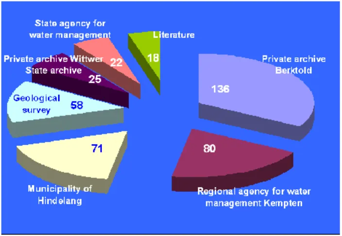
Fig. 1. Distribution of the total number of events for the different relevant archives.
Northern Spain, Ball (1995) for Canada, Wang and Zhang (1988) and Wang et al. (1991) for China, Nicholls (1988) for Peru and Australia, Pfister (1988, 1998), Pfister et al. (1988) and Pfister and H¨achler (1991) for Switzerland and Fliri (1998) for Tyrol, Austria. Data from diaries for example have been collected by Glaser et al. (1991) for Madras, India and by Tagami (1991) for Japan. Glaser (2001) even constructed a climate atlas for central Europe out of written and proxy data.
In most cases the areas analysed in the papers mentioned above were very much larger than the small areas concen-trated upon by the HANG project. The advantage of the HANG project is that the data gathered for a very limited region exactly shows the local hydrological and geomorphic dynamics, not a generalized picture of the area. The user of the resulting data bank gets precise and definite information about small scale catchment areas or individual places within the municipality in question, he does not have to draw con-clusions from bigger scale assessments.
4 Collecting the data
In order to ensure a systematic research of all informative records all archives relevant for the projected regions have to be found and listed depending on their significance. Espe-cially important are the archives of public authorities (like the administrative offices for hydrology and geology, local hy-drological offices, archives of municipal authorities), further-more forestry archives and private collections (chronicles, newspaper archives). Since many archives lack a modern and clearly structured registration, quite a lot of files need scru-tinizing for references leading to documents describing haz-ardous events. The archive yielding most documents about flood events naturally was the archive of the local hydro-logical office. Although the archive is, on the whole, very well structured, the older documents are just kept in bundles. Therefore, the research work took a few weeks, but the re-sult was convincing (Fig. 1). More time had to be spent in
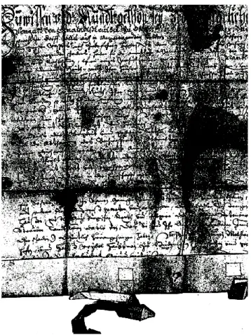
Fig. 2. Original document with references to local floods from 1644 (Municipality of Hindelang).
the archives of the municipality of Hindelang and the State Archive, where even less hints for the existence and where-abouts of relevant documents are existing.
The data collected (events larger than a specified thresh-old) is noted under certain aspects (time, place, kind of event, cause, extent, among others) in a specially designed registra-tion sheet. A resulting data bank provides a systematic listing of all events collected. Due to the fact that most of the ref-erences dating back more than 30 or 40 years are hardly re-membered by the people (as investigations of Wagner – oral communication – have shown), especially data from the past centuries are welcomed and have special significance. To gain sufficient data for evaluating flood risks a considerable amount of floods have to be assessed. Only far-reaching se-ries for one river ensure an adequate interpretation of possi-ble damaging effects. The enlargement of the chronological window moreover enables us to reduce the sampling uncer-tainty. The more information about one event we are able to collect, preferably data deriving from different types of archives, the better our basis for interpretation will become.
5 Criticism of sources
Historical written documents can roughly be divided into two types of documents. Most documents are official ones, with
usually only short descriptions of the events but lengthy list-ings of occurred damages and, eventually, provisional mea-sures for the future. Only few, but often very valuable doc-uments are personal comments or even descriptions of the chronological process of an event. Some of the older docu-ments are partly damaged (yellowed, torn) and hardly deci-pherable (Fig. 2). In both cases, the description of the event in question, the damages and the measures taken have to be analysed with caution. Some expressions in the texts like “the worst flood in history” are only of limited value, be-cause people cannot remember most events once they date back more than about 40 years. Many documents, there-fore, do not allow proper quantification, some do not even allow a satisfying localization. Baron (1995) calls this kind of data binominal data. With this data, e.g. a flood can be dated, described, evaluated and even categorised, but often “hard data” comparable to scientific measurements, like the amount of precipitation or the rate of discharge, is not avail-able. Deductions can be made from the type of precipita-tion (like deluge or steady rain). Torrential rain is typical for mountainous areas and the high flow gradients of the torren-tial rivers lead to high peak discharges in short time. Usually a certain grade of localization is possible with some of the damaged fields, roads, bridges or houses known.
Among the different documents investigated by HANG, a wide variety concerning reliability and quality can be stated. Almost no document before the onset of scientific measur-ing provided objective data concernmeasur-ing volume, velocity, ex-tension or the like (censored data) and more consist of data evaluated and praised by Baron (binominal data, 1995). Most documents only state the exceeding of a certain level of age, for example the fact that a river left its bed, or dam-ages to infrastructure, goods and people, which largely re-main subjective and, in parts, unclear, like the fact that a cer-tain bridge had been destroyed or that house number 49 was damaged. Although one can find the bridge and the house on ancient or recent maps, and, therefore, calculate the rel-ative destruction a certain event must have had, an absolute measurement is not possible.
Especially older documents, however, show a pretty sat-isfying degree of precision among the “unscientific” data. Only events of some importance seem to have found entry in the archives and have been recorded precisely as a conse-quence. Whereas documents from administrative offices ap-pear to have particularly well collected details about a certain event, even in the pre-instrumental period, older documents coming from municipal archives due to their legal character show a surprising quality when it comes to clearly stating place and time, and usually also intensity and reason for the event in question. The quality of data collected from Hinde-lang clearly support Wang and Zhang’s (1988) and Baron’s (1995) statement that written documents in many cases are more reliable than proxy data or even early scientific mea-surements.
Younger documents like texts from the offices for wa-ter management or from the municipalities are more precise overall. They often include instrumental records and were
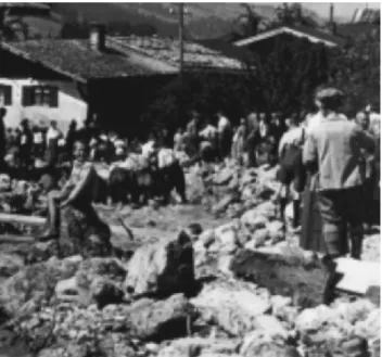
Fig. 3. Photograph of flood damage in Bad Oberdorf from 1924 (M. of Hindelang).
written by professionals in their fields. Remarks about the meteorological background or the chronology of the event become more frequent. In addition, photographs for some of the younger events show degrees of damage to houses and infrastructure and help evaluate the gravity of an event (Fig. 3). On the other hand, pictures are often taken once the event itself is over, so that the informational value of pho-tographs is also limited. Last but not least one has to bear in mind that not all events find entry in written documents. One can assume that all graver events are documented, but especially the smaller ones do not always appear in historical documents. Many documents from the 15th to 18th century only state the month or year of an event, some are about repa-rations or measures for the future and only mention that an event had taken place so that there is no proper date avail-able. It can be assumed that during these centuries some more events have taken place but were not recorded.
6 Results
The municipality of Hindelang has an archive reaching back to Renaissance times with a good number of old documents. But for most of the events in total references have been col-lected by a family of local chroniclers. More than 30% of a total of about 400 recorded references for events can be found in their collection of climatological dates (136 out of a total of 410). Around 50% of the information gathered came from hydrological and geological offices (situated in Munich and Kempten) and the municipality of Hindelang (Fig. 1).
The bulk of events from the Hindelang area are flood events (251 references), much less are of geomor-phic/geological nature (debris flows and landslides, 100 references), quite a few snow avalanches have also been
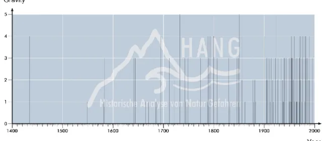
Fig. 4. Age of the references and the resulting events.
recorded (59 references). Naturally most of the damage oc-curs with floods, since the villages usually centre around bridges or fords crossing the rivers, and are therefore vulner-able. Geomorphic/geological events and avalanches usually tend to happen in areas with less inhabitants and thus are not always considered worth reporting.
About two thirds of all references for hazardous flood inci-dents (177 out of 251) have been found for the 20th century. Since the foundation of state run offices for water manage-ment in Bavarian provinces in the latter half of the 19th cen-tury the registration of natural disasters connected with rivers has dramatically improved. Consequently, the fact that we recorded more findings from the more recent centuries com-pared to earlier times not necessarily means that there are in fact more hazardous incidents nowadays, it has to be under-stood as a sign of better registration owing to the adminis-tration and the greater interest of people in natural hazards due to growing awareness. Additionally, more people have settled in endangered areas and more goods are threatened. 70 references date back to the first half of the 20th century, where a lot of documents have been lost due to World War II (Fig. 4).
Most documents about geomorphic/geological events and avalanches came from the 20th century, only very few refer-ences are older. With both kinds of disaster an exact dating is often impossible. Once a damage occurred, the event may be remarked in a written document, but there is usually only a terminus ante quem.
Very desirable are documents from different archives, par-allelly shedding light on the same event. Unfortunately more than 80% of the events have only been mentioned in one sin-gle document. Only younger events have found entry in more than one archive and are, consequently, better substantiated. As a consequence, as many archives as possible need scruti-nizing for singular references to hazardous events. The older documents are nevertheless of special importance since they tell us something about the continuity of natural disasters in the area.
More than 50% of all data for Hindelang were of at least satisfying degree. That means that a concrete date for an event was given and in addition more details regarding ori-gin, cause, damages and/or consequences. In about 15% of all references only a date was given with the remark that an event had taken place, but no further explanation or clarifica-tion were given. Still, even these simple remarks, especially when coming from older documents, give evidence of the ac-tivity of a certain river. Nevertheless, it must be stated that in several cases the documentary evidence for an event is com-parably slight, these dates have to be treated with caution.
7 Forms of application
In a first step the events are classified after their gravity. Avalanches are divided into three groups, the ones with yearly occurence in group 1, avalanches occuring once in ten years in group 2, and avalanches less than once in ten years in group 3. The geomorphic/geological events are summed up in areas especially susceptible to slides or debris-flows. Floods are divided into five classes after the degree of the damage done (with class 5 being the highest, meaning de-stroyed houses and infrastructure, and class 1 being the light-est one, meaning just high water without any known dam-age). A grouping of the rivers according to the gravity of their specific flood events yielded four different classes of river activity. A first result of the classification is a map of historical natural hazards (Map 2).
A second step is the visualization of well documented events. All concrete references are combined in one data sheet per locality to show the degree of gravity for a given event at a certain place or in the whole region. Most refer-ences describe flood events, but in some cases there are also geomorphic/geological incidents recorded as part of a bigger event. The resulting maps show the number of documented damages and their exact localization (Maps 3 and 4).
The advantage of such a map is that the extent of an event can be seen at a glance. The next step follows, if localizations of damages seen on the map are yet unknown (or forgotten) and thus new to the reader. One can in this case check the dot-shape-file which is connected with the data bank, where each damage has been recorded and listed. Together with the map of historical natural hazards the maps for certain events show areas in danger of frequent hazards. Additionally, the moun-tain torrents are listed in order of their dangerousness. Some of the torrents have not caused floods for several decades, but
used to be dangerous earlier in the last century. In some cases the torrents have been blocked or dams have been built. But in other cases, the natural situation of the vicinity is just as it was decades ago. Some torrents are only dangerous if heavy rain occurs in their catchment area. The miniature size of the catchment area may be the reason, why only rarely flood events appear in this torrent.
A well documented event shook Oberdorf in the summer of 1851. Many damages have been listed and 80 years later an employee with the Regional Agency for Water Manage-ment drew a map with the extent of the floods in 1851 and 1901 (Map 5). HANG-Data-Bank (HDB) Sheet No. 520 re-ports: “The mountain torrent left its river bed and destroyed a large part of the village and many fields. All rooms in the houses were filled with water, the inhabitants alone were able to get away from the flood in time. Almost all houses were filled up with stones, sand and soil up to the upper floors. The bridge in Bruck, undamaged for more than 100 years, has been swept away.” This quotation not only gives evidence for the enormous damage done to the village (exact localiza-tions follow in the document), it also gives us an idea of how frequent a disaster of this kind has happened in the area. An old bridge, unharmed for more than 100 years, has been not only damaged but destroyed completely. The ground floor of House No. 52 in Oberdorf was completely filled with debris, which caused the inhabitants to fully move entrance and all rooms which used to be on the ground floor to the first floor. By the help of old cadastral maps the extent of the flood of 1851 could be easily tracked and mapped.
A comparable event was the flood of 1924 (Map 4, Fig. 3). HDB Sheet No. 449 gives the exact places where damages occured and enables a comparably useful mapping. It also mentions the written sources which name the reason for the flood (“deluge”), the exact time (“after 16:30 PM”), and a kind of chronology (“the torrent first destroyed the riverside of House No. 57, then followed the road down to House No. 32” and so on). Endangered objects are named, so are the consequences which were demanded. (Other parts of the Os-trach valley are described, e.g. in the HDB Sheets Nos. 447, 451, 452, 578, 750, and 751.)
Apart from visualising the documented events, one can compare the data with data in existing data bases. Responsi-ble for the torrents of Hindelang is the Regional Agency of Water Management in Kempten, an administrative office of the Bavarian Ministry of Environment. This agency started in 1999 to file all events in a specially designed data bank. When the HANG project started in 2000, only two events had found entry so far. HANG added another 148 events from six centuries to the existing data bank. Many torrents show activity only once in a while, in many cases less than once in a decade. In order to properly assess activity and dan-gerousness of torrents also older events have to be included.
For the existing geo risk data bank of the Bavarian Geo-logical Survey HANG added nine localities with sometimes frequent hazardous events. To the existing cadastral sur-vey of avalanches in the Bavarian State Agency for Water Management HANG contributed 17 new avalanche tracks.
Map 3: The flood of 1851.
Data from HANG, therefore, definitely substantially adds to a better understanding of processes in alpine environments and are highly appreciated by the responsible state offices. Since there is no existing data base including historical data for the Bavarian Alps which could be used by engineers and planners, data from HANG are a valuable source, es-pecially when concerning rivers, for politicians and hydrolo-gists alike.
8 Comparison with data from adjoining areas
As to the question of recurrence, HANG data indicate that, beyond any actually known event, severe floodings and slides have occurred not regularly but, still, every once in a while during the last five centuries. In Hindelang, for example, we have evidence for heavy floods among others in 1435, 1582, 1641, 1749, 1787, 1846, 1851, to name but a few incidents
Map 4: The flood of 1924.
from earlier centuries. Some flood events, like the ones in 1584, 1680, 1733, 1749, 1851 and others correspond well with the data collected by Fliri (1998) for the adjoining areas in Austria. Flood events in 1878, 1879, 1905 and some more can be found in eastern Switzerland as well, judging from the data published by Pfister (1998).
Comparisons with precipitation data from weather stations
within the study areas and eleven stations outside (between Salzburg in the east and Zurich in the west, Munich in the north and Bolzano in the south, the oldest of which started recording in the second half of the 19th century) show par-allels of high precipitation rates with flood event data from Hindelang in many cases, but not automatically. Sometimes the stations with the greatest distance recorded high
precipi-Map 5: Original map for flood events in Hinterstein in 1851 and 1901 (Regional agency for water management Kempten).
tation, while stations adjoining to the study area were incon-spicuous. In these cases a greater area of precipitation as that of mediterranean cyclones is probable. In some parts of the precipitation area the precipitation rates were high enough to trigger off a flood, in others the amount of water was too small. Many cases, on the other hand, show precipitation rates beyond 100 mm/day in the study areas, while neigh-bouring valleys only received 20 to 30 mm/day. In all cases where flood events were caused by thundershowers, the pre-cipitation rate, if known, was around 100 mm or more for the whole day.
Judging from the comparison between the HANG data, the historical data from neighbouring areas and the precip-itation lists from weather stations one can conclude that the historical data are precise regarding the date and the grav-ity of an event. They have been confirmed by numerous data from all stations. But on the whole the events recorded for the study area show a high degree of locality. Conse-quently, a lot of flood events can only be found locally, with no reference to other areas, or even countries, like the ones in 1641, 1781 or 1807. Consequently, flood events in other ar-eas found no entry in documents researched by HANG, like the flood catastrophe in Switzerland in the early October of 1789 (see Pfister, 1998). On the whole only a small
percent-age of concrete dates of flood events in Hindelang show par-allels with dates from neighbouring areas. Of the 113 dates investigated 71 are concrete days where flood events took place. Out of these 71 dates only seven correspond exactly and 14 correspond satisfactory with data from nearby Tyrol (see Fliri, 1998). The remaining 50 dates have no parallels in the neighbouring Tyrolean areas (data from more remote parts of Tyrol have not been considered). The best data from Switzerland comes from Gees (1997). From regions nearby (the area around Graub¨unden, Appenzell and St. Gallen) five good and ten satisfying parallels have been found for the 71 dates. The fact that considerably less dates correspond with the HANG dates is due to the greater distance of the compared areas. Other comparisons with data from Switzer-land (R¨othlisberger, 1991) and Germany (Glaser, 2001) show even less parallels because of the growing distance between Hindelang and the other regions. On top of that it must be stated that not only the gravest events found parallels in ad-joining areas. In some cases catastrophic events had no paral-lels in the neighbouring valleys, whereas some minor floods found good parallels in Austria or Switzerland.
It has to be concluded that small catchment areas in the Bavarian Alps react individually on climatic phenomena. Fronts do not show the same impact even on neighbouring valleys, and thunderstorms in the summer from cumulonim-bus clouds are of limited extension anyway. The question of clearly recognizable recurrence intervals has to be asked, and a specific statistical framework should be used with histori-cal information, considered as censored data (see Stedinger and Cohn, 1986).
A comparison with concentrations of flood events from central European rivers in Sturm et al. (2001) shows that the periods with more frequent and severe floodings in Hinde-lang (Fig. 5) does not compare to the more active periods of large river systems (Main, Rhine, Saale, Elbe, Weser). More-over, the majority of severe floods of large river systems oc-cured in the winter, while in Hindelang, as is the case with most Alpine catchment areas, the floods regularly occured in the summer. Apart from that, the sizes of the catchment areas are totally different. The catchment areas of Alpine torrents in the Ostrach valley often cover less than 1 km2. A fourth point to be kept in mind is that the type of precipitation lead-ing to high water levels in the Alpine rivers is different from the rivers in subdued mountain ranges or the lowlands. In the Alps thundershowers prevail, which cause high precipita-tion rates in very short time. The run-off process is triggered off very quickly and the maximum discharge is sometimes reached within minutes. Floods in high- or lowlands, where the river systems are large, are only reached after several days of persistent rain (the meteorological conditions of the Vb-situation after the classification of van Bebber is well known for heavy floodings downstream the Elbe for example).
As a consequence one can conclude from the results of the research work done by HANG:
– Hazardous events in Alpine catchments are usually
Fig. 5. Chronological distribution of flood events with respect to their severity.
events have affected both little and large basins.
– The events may only be investigated from documentary
sources about this area, sources from other areas usually give no information about events in other regions.
– The date of an event is not transferable to the date of an
assumed event in another area.
– No event may be deduced from a known event in a
neighbouring area.
– The catchment areas in the Alps in most cases are very
small and react individually on precipitation.
– No valid climatological trend for a larger region may
be directly concluded from results gathered from small catchment areas. Only the assessment of several con-nected study areas may allow more general climatolog-ical statements.
9 Outlook
The data investigated and assessed by HANG from docu-mentary sources are precise. They are confirmed by nu-merous data from weather stations and some parallel events from abroad. Since more than half of all documents of-fered at least satisfactory information on hazardous events, the method probed in the field can be characterised as valid. Most data has been collected for flood events, though also data for geomorphic/geological events and avalanches led to a surprising number of additions to complement existing of-ficial data bases. But it is foremost the Agencies for Wa-ter Management which profit from data distilled from docu-mentary sources to enlarge their data bases. The majority of documents can be found in administrative archives, most of which unfortunately only offer data for the 20th century.
As a result, the search for older data in order to ensure a sufficient string of data for the assessment of the hazardous potential of a river always has to include non-administrative archives, such as private or municipal ones, and needs (with respect to the documents often being in an almost illegible state) cooperation with historians. Without intense inter-disciplinary work on historical floods reconstructed by way of analysing written documents no satisfying results will be reached. With respect to the considerable operational bene-fits of the historical analysis of natural hazards we come to the conclusion that such analysis definitely has to be included in all further investigations of hydrological or geomorphic dynamics in inhabited mountainous regions.
Moreover, the monetary aspect has to be kept in mind. Blocking up mountain torrents in many cases already asks for six-figured amounts in Euro. If the dimension of damming or blocking is not adequate, few years later similar amounts have to be met, when the torrents are treated again. A thor-ough analysis of prominent areas, with total costs well below the sum mentioned above, will certainly help reduce the costs for hazard mitigation in the Alps.
Acknowledgement. HANG receives funding from the Bavarian
Ministry of Environment.
References
Ball, T. F.: Historical and instrumental evidence of climate: Western Hudson Bay, Canada, 1714–1850, in: Climate Since A.D. 1500 (London) edited by Bradley, R. S. and Jones, P. D., p. 40–73, 1995.
Barnikel, F., Frank, C., and Becht, M.: “Natural hazard maps in the Alps derived from historical data on a local scale – Results from the Tegernsee valley (Bavaria, Germany)”, in: Palaeofloods, His-torical Data and Climatic Variability: Applications in flood risk assessment (Barcelona), edited by Thorndycraft, V. R., Benito, G., Barriendos, M. and Llasat, M. C., p. 155–160, 2003.
Baron, W. R.: Historical climate records from the northeastern United States, 1640 to 1900, in: Climate Since A.D. 1500 (Lon-don), edited by Bradley, Raymond, S., and Jones, P. D., p. 74–91, 1995.
Barriendos, M., Coeur, D., Lang, M., Llasat, M. C., and Naulet, R.: Stationarity analysis of historical flood in France and Spain with a classification of events based on historical flood levels or damages, Geophysical Research Abstracts 4/2002, Abstracts of the Contributions of the 27th General Assembly of the European Geophysical Society, Nice, France, 21–26 April, 2002.
Benito, G., Rico, M., Sanchez-Moya, Y., Sopena, A., and Thorndy-craft, V. R.: Magnitude and frequency of palaeofloods in the upper Guadalentin basin (SE-Spain) during the last 1000 years, Geophysical Research Abstracts 4/2002, Abstracts of the Contri-butions of the 27th General Assembly of the European Geophys-ical Society, Nice, France, 21–26 April, 2002.
Borisenkov, Y. P.: Documentary evidence from the U.S.S.R., in: Climate Since A.D. 1500 (London), edited by Bradley, R. S. and Jones, P. D., p. 171–183, 1995.
Br´azdil, R.: The history of floods on the rivers Elbe and Vltava in Bohemia, in: Aktuelle und historische Hochwasserereignisse (Erfurter Geographische Studien 7; Erfurt), edited by P¨ortge, K.-H. and Deutsch, M., p. 93–108, 1998.
Calenda, G., Calvani, L., Mancini, C. P., and Volpi, E.: Reconstruc-tion of the extreme flood series of the Tiber river in Rome from the XV. century, Geophysical Research Abstracts 4/2002, Ab-stracts of the Contributions of the 27th General Assembly of the European Geophysical Society, Nice, France, 21-26 April, 2002. Camuffo, D. and Enzi, S.: Reconstructing the climate of northern Italy from archive sources, in: Climate Since A.D. 1500 (Lon-don), edited by Bradley, R. S. and Jones, P. D., p. 143–154, 1995. Coeur, D., Lang, M., Naulet, R., Burnet, R., and Strazzeri, D.: Histoire et connaissance des ph´enomenes naturels extremes, Ing´enieres-EAT, p. 15–26, 1998.
Fliri, F.: Naturchronik von Tirol (Innsbruck), 1998.
Gees, A.: Analyse historischer und seltener Hochwasser in der Schweiz (Geographica Bernensia, G 53; Bern), 1997.
Glaser, R.: Historische Hochw¨asser im Maingebiet – M¨oglichkeiten und Perspektiven auf der Basis der historischen Klimadaten-bank Deutschland (HISKLID), in: Aktuelle und historische Hochwasserereignisse (Erfurter Geographische Studien 7; Er-furt), edited by P¨ortge, K.-H. and Deutsch, M., p. 109–128, 1997. Glaser, R.: Klimageschichte Mitteleuropas (Darmstadt), 2001. Glaser, R., Militzer, S., and Walsh, R.: Weather and climate at
Madras, India, in the years 1732-1737 based upon an analysis of the weather diary of the German missionary Geisler, W¨urzburger Geographische Arbeiten 80, p. 45–86, 1991.
Henfling, E. and Pflaumbaum, H.: Neue Aspekte zur klimatis-chen Interpretation der hohen pharaonisklimatis-chen Nilflutmarken am 2. Katarakt aus ¨agyptologischer und geomorphologischer Sicht, W¨urzburger Geographische Arbeiten 80, p. 87–109, 1991. Mart´ın-Vide, J. and Barriendos Vallv´e, M.: The use of rogation
cer-emony records in climatic reconstruction: A case study from
Cat-alonia (Spain), Climatic Change, 30, p. 201–221, 1995. Nicholls, N.: More on early ENSOs: Evidence from Australian
doc-umentary sources, Bulletin of the American Meteorological So-ciety, 69/1, p.4–6, 1988.
Ogilvie, A. E. J.: Documentary evidence for changes in the cli-mate of Iceland, A.D. 1500 to 1800, in: Clicli-mate Since A.D. 1500 (London), edited by Bradley, R. S. and Jones, P. D., p. 92–117, 1995.
Pfister, C.: Klimageschichte der Schweiz 1525–1860 (Academia Helvetica 6; Bern), 1988.
Pfister, C.: Raum-zeitliche Rekonstruktion von Witterungsanoma-lien und Naturkatastrophen 1496–1995 (Schlussbericht NFP 31; Z¨urich), 1998.
Pfister, C. and H¨achler, S.: Uberschwemmungskatastrophen im¨ Schweizer Alpenraum seit dem Sp¨atmittelalter, W¨urzburger Ge-ographische Arbeiten 80, p. 127–148, 1991.
Pfister, C., B¨utikofer, N., Schuler, A., and Volz, R.: Witterungsex-treme und Waldsch¨aden in der Schweiz (Bern), 1988.
P¨ortge, K.-H. and Deutsch, M.: Hochwasser in Vergangenheit und Gegenwart, Rundgespr¨ache der Kommission f¨ur ¨Okologie 18, p. 139–151, 2000.
R¨othlisberger, G.: Chronik der Unwettersch¨aden in der Schweiz (Berichte der Eidgen¨ossischen Forschungsanstalt f¨ur Wald, Schnee und Landschaft 330; Birmensdorf), 1991.
R¨othlisberger, G. and Keller, H. M.: Historische Hochwasser in der Schweiz – Ursachen und jahreszeitliche Verteilung, Inter-praevent 1992/1, p. 105–116, 1992.
Schiller, H.: Ermittlung von Hochwasserwahrscheinlichkeiten am schiffbaren Main und ¨uberregionaler Vergleich der Ergebnisse”, Beitr¨age zur Hydrologie, Sonderheft 6 (Kirchzarten), p. 79–101, 1987.
Stedinger, J. R. and Cohn, T. A.: Flood frequency analysis with his-torical and paleoflood information, Water Resources Research, 22/5, p. 785–793, 1986.
Sturm, K., Glaser, R., Jacobeit, J., Deutsch, M., Br´azdil, R., Pfister, C., Luterbacher, J., and Wanner, H.: “Hochwasser in Mitteleu-ropa seit 1500 und ihre Beziehung zur atmosph¨arischen Zirku-lation”, Petermanns Geographische Mitteilungen 145, p. 14–23, 2001.
Sutcliffe, J. V.: The use of historical records in flood frequency analysis, J. Hydrology, 96, p. 159–171, 1987.
Tagami, Y.: Some aspects of climatic variation in Japan from the 17th to the 19th centuries – An attempt at reconstruction based on data from diaries, W¨urzburger Geographische Arbeiten 80, p. 241–251, 1991.
Wang, P. and Zhang, D.: An introduction to some historical gov-ernmental weather records of China, Bulletin of the American Meteorological Society, 69/7, p. 753–758, 1988.
Wang, R., Wang, S., and Fraedrich, K.: An approach to reconstruc-tion of temperature on a seasonal basis using historical docu-ments from China, International Journal of Climatology, 11, p. 381–392, 1991.