LETTER
From dwindling ice to headwater lakes: could dams replace glaciers
in the European Alps?
Daniel Farinotti1,5
, Alberto Pistocchi2,5
and Matthias Huss3,4
1 Swiss Federal Institute for Forest, Snow and Landscape Research(WSL), Birmensdorf, Switzerland
2 European Commission, DG Joint Research Centre(JRC), Institute for Environment and Sustainability, Ispra, Italy 3 Department of Geosciences, University of Fribourg, Fribourg, Switzerland
4 Laboratory of Hydraulics, Hydrology and Glaciology(VAW), ETH Zurich, Zurich, Switzerland 5 Author to whom any correspondence should be addressed.
E-mail:[email protected]@jrc.ec.europa.eu
Keywords: glacier melt, dam storage, climate change, mitigation Supplementary material for this article is availableonline
Abstract
The potential exploitation of areas becoming ice-free in response to ongoing climate change has rarely
been addressed, although it could be of interest from the water management perspective. Here we
present an estimate for the potential of mitigating projected changes in seasonal water availability
from melting glaciers by managing runoff through reservoirs. For the European Alps we estimate that
by the end of the century, such a strategy could offset up to 65% of the expected summer-runoff
changes from presently glacierized surfaces. A
first-order approach suggests that the retention volume
potentially available in the areas becoming deglacierized is in excess of the volume required for
achieving the maximal possible mitigation by more than one order of magnitude. Obviously, however,
such a strategy cannot compensate for the reduction in annual runoff caused by glacier ice depletion.
Our estimates indicate that by 2070–2099, 0.73±0.67 km
3a
−1of this non-renewable component of
the water cycle could be missing in Alpine water supplies.
1. Introduction
Environments significantly influenced by the presence of seasonal snow or glaciers are hotspots regarding the impacts on water availability in response to expected climate change(e.g. Beniston2003, Viviroli et al2011, Mankin et al2015). With warmer temperatures, both
the duration and the spatial extent of the seasonal snow cover are projected to decrease (e.g. Barnett et al2005, Steger et al2013, Brutel-Vuilmet et al2013)
and glaciers are expected to retreat significantly (e.g. Zemp et al 2006, Radić and Hock 2011, Cogley et al2012). This is anticipated to have influences on
water resources at different time scales, and to affect runoff seasonality in particular (for reviews, see de Jong et al 2005, Schaner et al 2012, Radić and
Hock 2014): while increased discharge is expected
during the winter and spring time, a significant decrease is projected for summer and fall(e.g. Bavay et al2009, Huss2011, Berghuijs et al 2014). Glacier
recession, moreover, is known to have an effect on longer-term water availability, with an initial phase of increased water yields in response to increased melt rates, and a later stage of decreased runoff due to the reduction in actual glacier size(e.g. Hock et al2005, Farinotti et al2012, Bliss et al2014).
Glacier recession has generally been connoted negatively, with concerns emerging from the impacts of reduced water yields in summer(Piao et al2010, Immerzeel et al2010), the impacts of a changed
land-scape in touristic regions(Scott2006, Scott et al2007),
or the hazards induced by the destabilization of for-merly frozen grounds(Carey2005, Kääb et al2005, Fischer et al 2006) and the associated potential for
more frequent glacier lake outburstfloods (Richard-son and Reynolds2000, Dussaillant et al2010).
Water-availability related concerns are particularly promi-nent in arid regions, such as Central Asia or parts of Southern America, in which the dependence on snow and glacier melt for regional supply is most important OPEN ACCESS
RECEIVED 22 December 2015 REVISED 30 March 2016 ACCEPTED FOR PUBLICATION 28 April 2016 PUBLISHED 20 May 2016
Original content from this work may be used under the terms of theCreative Commons Attribution 3.0 licence.
Any further distribution of this work must maintain attribution to the author(s) and the title of the work, journal citation and DOI.
(Hagg and Braun2005, Kaser et al2010). Such regions,
moreover, often coincide with economically less developed areas, thus lacking the potential capability of mitigating the impacts through engineering solu-tions(Orlove2009).
The potential of exploiting newly deglacierized areas has not often been addressed, although it was suggested earlier that new proglacial lakes, likely to form in such environments, could take over important roles in hydropower production or the management of both water resources and natural hazards (Frey et al2010, NELAK2013). In support of such a possible
utilization, the supposed‘neutrality’ in terms of ecolo-gical value of the surfaces becoming ice-free is some-times mentioned: Since the exposed forefields are bare, non-vegetated and relatively simple in their eco-system structure(e.g. Nemergut et al2007, Hodson et al 2015), a potential exploitation could result in
comparatively limited ecological impacts. Similarly, it could be argued that an intervention in the upper-most part of a given river stretch would have only minimal consequences on river continuity.
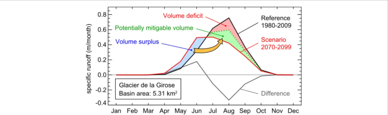
This opens the admittedly provocative question on whether newly deglacierized areas could be used to mitigate, at least partly, the hydrological effects caused by the shrinkage of glaciers and the snow cover. Postu-lating that preserving the current natural runoff regime is a desirable target, the additional water expec-ted during spring time under changed climate condi-tions could in fact be temporarily stored and seasonally transferred in order to compensate for the reduction in summer water yields(figure1). In such a
scenario, reservoirs would replace part of the hydro-logical effect currently provided by glaciers and the seasonal snow pack.
In this study we focus on the European Alps, a region expected to be significantly affected by future changes in snow- and glacier-fed water resources(e.g. Beniston et al2011, Huss2011), and use a first-order
approach in order to assess whether‘replacing glaciers with dams’ is an option theoretically worth
considering. For doing so, we use the output of a glo-bal glacier model(GloGEM) (Huss and Hock2015) in
combination with latest climate projections (Taylor et al2012) to assess the evolution of both glacier extent
and runoff until the end of the century. We then com-pute storage capacities required for achieving the max-imal possible mitigation, and compare these results to an estimate of retention volumes that could hypotheti-cally be installed in newly deglacierized forefields. While we don’t discuss the technical feasibility or any of the actual ecological implications of such a hypothe-tical way of action, we provide afirst assessment of the maximal effect that such a strategy could potentially achieve.
2. Methods
2.1. Runoff from presently glacierized surfaces We define glacier runoff Qgl as the sum of liquid
precipitation (rain) that does not refreeze within a glacier, and snow- and ice-melt that stems from currently glacierized areas(glacier runoff as defined by concept 1 in Radić and Hock (2014) neglecting
evaporation). The individual components of Qgl are
taken from the GloGEM by Huss and Hock(2015) (see
section 2.2) and evaluated within individual
catch-ments defined by present glacier extent. Presently glacierized areas are discerned with the glacier outlines provided by the Randolph Glacier Inventory(Pfeffer and The Randolph Consortium 2014) version 4.0
(RGIv4.0; Arendt et al2014), which refers to the year
2003 for Central Europe (Paul et al 2011). For all
analyses, the area contributing to Qgl isfixed to the
glacier extent given by the RGI. This is to avoid suggesting misleadingly large reductions in future water yields in case of shrinking catchment area due to glacier retreat.
For quantifying the relative importance of glacier contributions to total runoff, we consider the percental runoff share that stems from presently Figure 1. Illustration of the potential mitigation through water management. Volume surplus(light blue) is the runoff volume that, according to the projection, will be in excess to the runoff in the reference period during late spring and early summer. This volume could potentially be transferred into late summer and early autumn(arrow) in order to partially compensate (light green) the runoff reduction caused by glacier depletion. Volume deficit (light red) is the net reduction in annual runoff. The example refers to Glacier de la Girose, France.
glacierized surfaces, that is
= · ( )
RSgl 100 Qgl Qtot. 1
Here, Qtot is the total runoff at the considered
location, and is estimated through a weighted flow accumulation operation(e.g. Pistocchi and Penning-ton 2006, Pistocchi 2014) of the climatological
monthly composite runofffields provided by the Uni-versity of New Hampshire/Global Runoff Data Center (Fekete et al2002). The analysis is performed on the
GTOPO30 digital elevation model(DEM) provided by the HYDRO1k data base (https://lta.cr.usgs.gov/
HYDRO1K). The DEM has a resolution of 30
arc-sec-onds(about 1 × 1 km), which is maintained in all our results.
In principle, RSglis defined for any time
aggrega-tion, but only summer(July, August, September) and annual values are considered in the following. Melt-water transit-time along the considered streams(in the order of some days to a few weeks; Huss2011) are
therefore neglected.
Derived values of bothQtotand RSgl, are validated
against independent estimates based on station mea-surements (supplementary figures S.1 and S.2). The general agreement is satisfactory although a tendency to underestimate Qtot in relatively small catchments
(i.e. catchments with small runoff) emerges. This cau-ses RSgl to be overestimated in such cases. However,
since RSgl is only used for quantifying the relative
importance of glacier runoff during the reference per-iod 1980–2009 (and thus is irrelevant for the con-siderations on potential mitigation and storage volume), this has no effect on the presented interpretations.
2.2. Glacier and climate evolution
GloGEM (Huss and Hock 2015) computes glacier
mass balance and associated glacier geometry changes on a glacier-by-glacier basis. Glacier outlines are obtained from the RGI v4.0 and are intersected with the DEM provided by the shuttle radar topography mission(Jarvis et al2008) in order to derive relevant
topographical information (glacier hypsometry, aspect, and slope in particular). For each glacier, the information is aggregated into 10 m elevation bands, which is the resolution at which the model operates. The initial ice thickness distribution for every glacier is calculated with the method presented by Huss and Farinotti(2012), updated to the RGIv4.0 (Huss and
Hock2015). The climatic glacier mass balance—that is
the balance of snow accumulation, snow- and ice-melt, and refreezing(Cogley et al2011)—is calculated
at monthly resolution based on air temperature and precipitation time series(Huss and Hock2015). These
time series are taken from ERA-Interim reanalysis (Dee et al2011) for the past (period 1979 to present)
and from the 5th phase of the coupled model intercomparison project(CMIP5; Taylor et al2012)
for the future(present to 2099). For CMIP5, results
from 14 different Global Circulation Models(GCMs) and 3 different representative concentration pathways (RCP 2.6, 4.5, and 8.5; Meinshausen et al2011) are
considered(supplementary figure S.3). The so-com-puted glacier mass balance is then used in combination with the parametric approach by Huss et al(2010) for
adjusting glacier surface elevation and extent on a yearly basis.
The model is calibrated at the regional scale with the consensus glacier mass-change estimates by Gard-ner et al(2013), and is validated against observations of
both glacier mass balances(in situ and geodetic mea-surements; WGMS 2012) and glacier area changes
(Fischer et al2014). For Central Europe, model
perfor-mance is high, with average deviations in the calcu-lated glacier-wide (point) mass balance of±0.04 (± 0.16) m water equivalent a−1, and average area-change rates reproduced within±0.04% a−1 (see supplementary tables 5–7 in Huss and Hock2015).
For additional details on the glaciological model-ling, including details on the downscaling of the clima-tological data, and the calibration and validation procedures, refer to Huss and Hock(2015).
2.3. Computation of mitigable volume change We compute the maximal potentially mitigable volume change for a given scenario period as the sum of all positive volume differences with respect to the mean runoff volume during the reference period 1980–2009 (figure1). All calculations are performed
using monthly values. We present results for a near-term(2010–2039), a medium-term (2040–2069), and a long-term horizon (2070–2099). The monthly differences are computed on a glacier-by-glacier basis for simulations appertaining to the same GCM ensemble member, and aggregated to the resolution of the HYDRO1k DEM(1×1 km). The same DEM is used for deriving flow directions with which the aggregated values are accumulated downstream. Both the derivation of theflow directions and the downstreamflow accumulation follows Jenson and Domingue(1988).
Presented results refer to the mean of all available GCMs, while individual RCPs are considered sepa-rately. We use the standard deviation between indivi-dual GCM results in order to quantify the uncertainty linked to climate model choice, and the standard deviation of the time series of a given GCM in order to quantify internal year-to-year variability. Pre-sented uncertainties refer to the combination of both effects(added in quadrature). The uncertainty intro-duced by GloGEM(see previous section) is assumed to be included in this range as typical year-to-year variations in glacier mass balance are larger than the associated uncertainties by about one order of magnitude.
3. Results
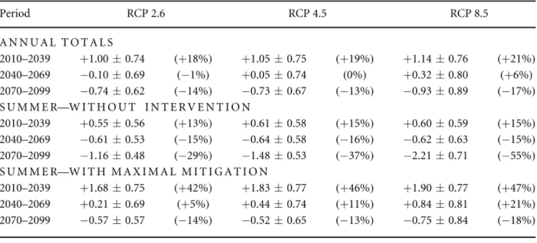
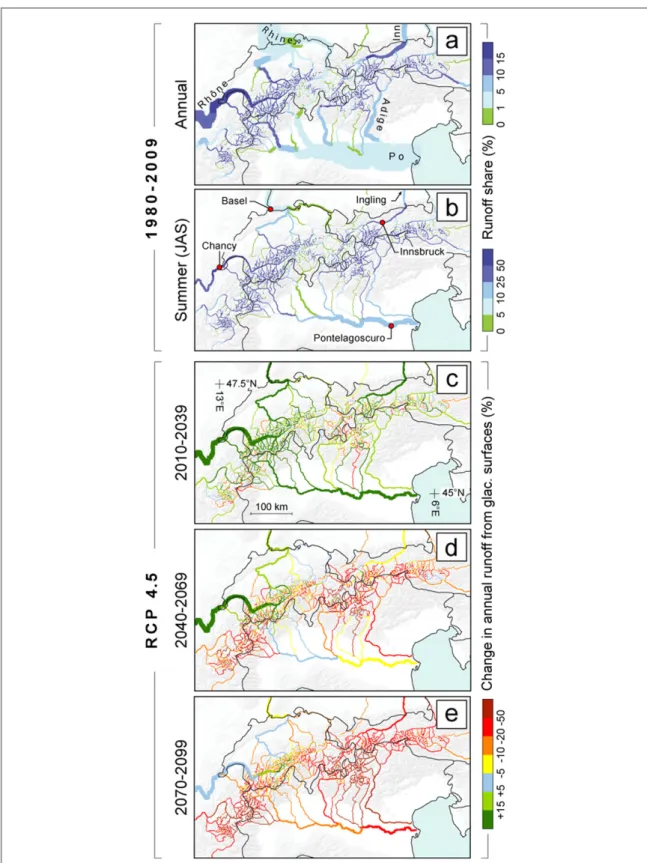
Presently glacierized surfaces in the European Alps(ca. 2050 km2 on 3800 glaciers) contributed an average runoff volume of 5.28±0.48 km3a−1 during 1980–2009 (table 1). About 75% of this volume
(3.97 ± 0.36 km3
a−1) occurred between July and September (summer hereafter). The spatial distribu-tion of the resulting runoff share is shown in figures 2(a) and (b). Regions with very important
glacier contributions are found across the whole Alpine Ridge, with two main clusters around the common borders of France/Italy/Switzerland (Mont Blanc Massif and Pennine Alps) and Austria/Italy/ Switzerland (Bernina and Adamello–Presanella Ranges, as well as Ortler Alps and Ötztal Alps).
In terms of relative importance, the picture is simi-lar for both annual and summer values(figures2(a)
and(b) respectively), although the actual magnitude can largely differ. For the Mont Blanc region, for example, the annual runoff-share from glacierized surfaces is estimated to be around 20%, whereas this share increases to more than 60% during the summer months.
Also for the major low-lying rivers, the runoff-share from presently glacierized surfaces can be sig-nificant. Summer (annual) values for the Rhône at Chancy, the Inn at Innsbruck, the Po at Pontela-goscuro and the Rhine at Basel(see figures2(a) and (b)
for locations) are in the order of 53 (15), 38 (14), 11 (2) and 6%(2%), respectively, with uncertainties in the range of 25% of the estimated values. At its confluence with the Danube at Ingling, the Inn is estimate to still have an annual(summer) glacier runoff share of 3% (10%). These values compare well with the results by Huss(2011), although the observed tendency of
over-estimating the share of glacier runoff in smaller basins seems to re-emerge(see section2.1).
At the Alpine scale, the total runoff yield from pre-sently glacierized surfaces is expected to increase sig-nificantly in the short term (+1.05 ± 0.75 km3
a−1by 2010–2039 according to RCP 4.5) and to decrease in the long term(−0.73 ± 0.67 km3a−1 by 2070–2099, RCP 4.5). The general evolution is similar for other RCPs although differences occur as a result of differing temperature and precipitation projections(see table1
and supplementaryfigure S.3).
Without any intervention, the temporal evolution of the summer runoff contributions(QglJAS) is similar
to the annual ones, although appreciable reductions in the total water yield are expected in the mid-term already(table1). It is important to note, however, that
at the local scale such effects are visible even in the short term:figures2(a)–(c) presents projected changes
in QglJASfor RCP 4.5(results for RCPs 2.6 and 8.5 are
given in supplementaryfigures S.4 and S.5, respec-tively) and shows that significant reductions are expec-ted in the easternmost and westernmost parts of the Alps in particular (figure 2(a)). Such a decrease in
water availability becomes widespread in the mid term (figure2(b)) and is virtually ubiquitous for the long
term(figure2(c)).
Reductions in QglJAS are substantially less impor-tant when surplus volumes occurring in the former part of the year are virtually transferred to the summer months through temporary storage in hypothetical reservoirs(figures2(d)–(f)). On the Alpine scale, the
expected decrease in summer runoff could even be off-set entirely in the mid term for all considered RCPs (table1), although the statement does not hold true at
the local scale(figure2(e)). On average for the period
2070–2099, the results suggest that about two thirds (65%) of the change in summer runoff from presently glacierized surfaces could be mitigated through active water management. Also at the local scale the impacts of such a strategy are significant. Figures2(g)–(i) show
the differences between runoff reductions in the case Table 1. Projected changes in total runoff from presently glacierized surfaces for the European Alps. Changes are
given with respect to the reference period 1980–2009 and refer to yearly totals (first block), summer (July–September) totals without intervention(second block), and summer totals with implementation of the maximal potential mitiga-tion(third block). Values are in km3. Mean runoff volumes for the reference period are given at the end of the table. Confidence intervals refer to the 95% level.
Period RCP 2.6 RCP 4.5 RCP 8.5 A N N U A L T O T A L S 2010–2039 +1.00±0.74 (+18%) +1.05±0.75 (+19%) +1.14±0.76 (+21%) 2040–2069 −0.10±0.69 (−1%) +0.05±0.74 (0%) +0.32±0.80 (+6%) 2070–2099 −0.74±0.62 (−14%) −0.73±0.67 (−13%) −0.93±0.89 (−17%) S U M M E R—W I T H O U T I N T E R V E N T I O N 2010–2039 +0.55±0.56 (+13%) +0.61±0.58 (+15%) +0.60±0.59 (+15%) 2040–2069 −0.61±0.53 (−15%) −0.64±0.58 (−16%) −0.62±0.63 (−15%) 2070–2099 −1.16±0.48 (−29%) −1.48±0.53 (−37%) −2.21±0.71 (−55%) S U M M E R—W I T H M A X I M A L M I T I G A T I O N 2010–2039 +1.68±0.75 (+42%) +1.83±0.77 (+46%) +1.90±0.77 (+47%) 2040–2069 +0.21±0.69 (+5%) +0.44±0.74 (+11%) +0.84±0.81 (+21%) 2070–2099 −0.57±0.57 (−14%) −0.52±0.65 (−13%) −0.75±0.84 (−18%) 1980–2009 ANNUAL TOTAL: 5.28±0.48 SUMMER TOTAL: 3.97±0.36
without intervention and the case with maximal potential mitigation(that is the effectively mitigable change), and highlight that the largest potential is available in regions that currently have high degrees of glacierization. This observation, which might seem
contra-intuitive atfirst, can be explained by the fact that these regions are also expected to experience the largest changes in annual runoff regime, which is the pre-requisite for the mitigation strategy defined here (see figure1).
Figure 2. Past and future runoff contribution from presently glacierized surfaces. The mean annual(a) and summer (b) runoff share form presently glacierized surfaces(see section2.1for definition) is given for the reference period 1980–2009. The expected change in annual runoff from the same surfaces for 2010–2039 (c), 2040–2069 (d), and 2070–2099 (e) is expressed as a relative change with respect to the reference period. Changes(means over all considered GCMs) refer to RCP 4.5. Results for RCPs 2.6 and 8.5 are shown in supplementaryfigure S.6. In (a) and (b), river-width is proportional to the annual and July–August–September (JAS) runoff estimated from the UNH/GRDC data set, respectively. In (c)–(e) the width is proportional to the estimated annual runoff contribution from glacierized surfaces.
4. Discussion
The potential for mitigating the runoff reduction in the summer months is significant, and possibly of importance for individual regions. An estimate on the actual feasibility of such a water management strategy is thus of interest. This opens the question about how much of the required storage volume—in the order of 1 km3 over the European Alps by the end of the century—could potentially be installed. In order to minimize the impact of such important technical infrastructure, one strategy could be to focus on areas that are becoming ice-free due to glacier retreat. This would be in line with the general idea of artificially sustaining the effect that glaciers have in the hydro-logical cycle, and possibly result in smaller ecohydro-logical and socio-economic impacts when compared to pla-cing storage volumes in lower lying—and thus typi-cally vegetated and inhabited—valleys.
We perform such afirst-order assessment by vir-tually placing dams at the locations of current glacier terminus(determined through the RGI v4.0), and cal-culate the water volume of each individual lake being formed. We do this by making use of the subglacial bedrock topography provided by Huss and Farinotti (2012) and using watershed delineation as described
by Jenson and Domingue(1988). Dams are initially
placed perpendicularly to the glacier centre lines pro-vided by Machguth and Huss(2014) and are iteratively
rotated in 5° steps in order to minimize the ratio between required dam-wall area (product of crest length and average dam height) and obtained reservoir volume. Dam heights and widths are limited to a max-imum of 280 m and 800 m, respectively(the dimen-sions of the largest dam currently installed in the Alpine area) and ‘grown’ to the maximal size allowed by the local topographical conditions. Note that this procedure aims at estimating the maximal installable total reservoir volume, and is not intended to designed reservoirs capable of accommodating the volume sur-plus of individual glaciers only.
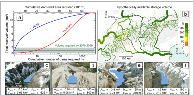
According to our analysis, the potentially install-able volume over the entire Alps exceeds the required volume by more than one order of magnitude (figure4(a)). In general, the hypothetically available
volume is largely in excess to the locally required one also at the sub-regional scale. Figure4(b) shows the
spatial distribution of the storage volume hypotheti-cally available as the percentage of the volume required for achieving the maximal potential mitigation at a given location(see figure3). As expected, the excess in
potentially available storage increases when moving downstream of the river network.
Clearly, such a widespread installation is neither desirable, nor technically or economically viable. Figure4(a) highlights, however, how a relatively small
set of the virtually created installations could already provide the required total storage volume—assuming these installation being fed by the surplus water
volumes of all surrounding glaciers. According to the results, less than a dozen of the largest virtual reser-voirs would be sufficient for providing the total volume required for achieving the maximal potential mitigation for the period 2070–2099 under the RCP 4.5 scenario. This is true even when considering the relatively large uncertainties introduced by the GCM spread, the RCP choice and the year-to-year variability(grey band in figure4(a)). The total
uncer-tainty, in fact, influences the required total storage volume by a factor of 2 at most(table1).
The necessity of collecting the surplus water volumes of surrounding glaciers into centralized reservoirs would clearly be a major technical challenge when adopting the described strategy. Figure 4(b),
however, suggests that sufficient storage volume is potentially installable also at the sub-regional scale, which would reduce the difficulty in centralizing the water from individual glaciers. Obviously, this decen-tralization of reservoirs would significantly increase the total number of required installations, and—on a par—the ecological and socio-economic impacts.
Four visualization examples(one for each major Alpine country) of the virtually installed reservoirs are shown infigures4(c)–(f). In this respect we would like
to emphasise that it is not our intention to suggest that these particular locations could indicate a priority for installation. Our analysis, in fact, clearly neglects a whole series of factors—linked to ecological, environ-mental, economical, and technical considerations amongst others—that would need to be considered when compiling an actual priority list. Similarly, our analysis does not take into account already-installed infrastructure—the exploitation of which should be first choice when considering an actual implementa-tion of the strategy—and does not consider potential competing interests, that would likely arise in case of a widespread installation of artificial reservoirs. In this respect, in fact, it should be noted that the typical sea-sonal production cycle of current hydropower infra-structure installed in the Alpine region, is exactly anticyclical with the mitigation strategy proposed here (current hydropower operators with storage typically accumulate water during summer in order to produce energy during winter).
Besides the limitations above, it has obviously to be noted that seasonally transferring a given runoff volume cannot compensate a reduction in the total annual runoff(see figure1). Even assuming
unchan-ged annual precipitation in the future, and neglecting increased evapotranspiration losses due to higher air temperatures, such a runoff decrease has to be expec-ted for high alpine catchments in response to glacier retreat. This is because glaciers losing large parts of their ice volume will largely reduce their contribution to runoff by ice melt. The water that contributes to runoff during the glacier recession phase can, hence, be considered as a non-renewable water contribution to the water cycle: once depleted, the water volume
Figure 3. Projected changes in mean summer(JAS) runoff form presently glacierized surfaces. The changes are expressed as relative differences with respect to(w.r.t) 1980–2009 and refer to the situation without any intervention (a)–(c), and the situation in which the maximal potentially mitigable volume(see figure1for definition) is realized (d)–(f). The difference between the two cases, that is the potentially mitigable change, is presented separately(g)–(i). Results are given for three different time periods (rows) and refer to RCP 4.5. Results for RCPs 2.6 and 8.5 are given in supplementaryfigures S.4 and S.5, respectively. River width is proportional to the estimated summer runoff.
Figure 4. Comparison of required and hypothetically available storage volume.(a) Cumulative number of dams (red) and wall-dam area(blue) required for achieving a given total storage volume according to the virtual set of constructed reservoirs. The storage volume required for achieving the maximal potential mitigation during 2070–2099 is shown (green). The grey band represents the uncertainty due to GCM spread, considered RCP, and year-to-year variability.(b) Ratio between (1) the maximal hypothetically available storage volume along a given river stretch and(2) the storage volume required for achieving the maximal potential mitigation (see figure1for definition) in summer runoff change at a given location (figures3(d)–(f)). The results refer to the period 2070–2099
and RCP 4.5. The widths of the rivers are proportional to the hypothetical storage volumes cumulated along a given river stretch. Four hypothetical reservoirs are visualized for examples in the(c) French, (d) Italian, (e) Swiss, and (f) Austrian Alps. For each example, the area(Alake) and volume (Vlake) of the generated lake, as well as the maximal height (Hdam) and the length of the crest of the required
dam(Ldam) is given (for comparison: Grande Dixence, the largest dam currently installed in the European Alps, hasAlake= 0.40 km3,
previously stored as ice will require decades to cen-turies, and drastically changed climatic conditions, to re-form.
The change in this non-renewable contribution is shown infigures2(c)–(e) for the three considered time
horizons and RCP 4.5(see supplementary figure S.6 for RCP 2.6 and 8.5). According to these results, a total of 0.73±0.67 km3
of water per year could be missing across the European Alps on average between 2070 and 2099(see table1). This is equivalent to roughly
80% of today’(s) annual freshwater consumption in Switzerland(SFSO2014), and highlights the need of
alternative water management strategies in addition to the hypothetical one presented above. A part from the obvious need of curbing current greenhouse gas emis-sions in order to minimize changes in global temper-ature, concepts aiming at a more efficient use of water resources are required.
5. Conclusions
Surfaces presently covered by glaciers are important water sources across the European Alps. During the period 1980–2009, glaciers provided an average 5.28±0.48 km3
a−1of freshwater. About three quar-ters of this volume occurred during July–September, resulting in significant glacier contributions also in large low-lying rivers including the Po, the Rhine, and the Rhône.
Important decreases in both annual and summer glacier runoff contributions are anticipated in response to ongoing climatic change. For an average emission scenario(RCP 4.5), annual runoff contribu-tions from presently glacierized surfaces are expected to decrease by 16% by 2070–2099—despite of nearly unchanged contributions from precipitation. The decrease is even more pronounced during the late summer months(JAS), for which a decrease of about 37% is projected. This highlights the need of adequate water management strategies in the future.
Here, we addressed the somewhat provocative question of whether replacing glaciers by dams could be an option theoretically worth considering in order to mitigate the projected changes in summer runoff. Postulating that keeping the past runoff regime of individual river stretches unaltered is a desirable tar-get, we quantify the water volume that could season-ally be transferred by means of reservoirs in order to compensate for such runoff reductions. We estimate that by 2070–2099, roughly 1 km3a−1of water could be seasonally redistributed, and that this volume would be sufficient to offset about two thirds of the expected changes in July–September runoff across the European Alps.
With afirst-order assessment that neglects a series of environmental, ecological and economic considera-tions, we compute the storage volume that could hypothetically be installed in areas becoming ice-free
due to glacier retreat. We estimate that this hypothe-tical volume is in excess of the required one by more than one order of magnitude, and that less than a dozen of large dams could theoretically provide the total required storage. Centralizing and redistributing the waters from the numerous glacierized catchments would, however, be a major technical challenge.
Obviously, the here addressed technocrat solution cannot compensate for the expected net reduction in annual water yields. For compensating this non-renewable component of the water cycle, alternative strategies aiming at a more efficient management of water resources are required.
Acknowledgments
This work was funded by the Swiss National Science Foundation and the European Communities 7th Framework Programme (Grant Agreement No. 603629-ENV-2013-6.2.1-Globaqua). We thank Bettina Schaefli for her helpful feedback on an earlier version of this manuscript, as well as the anonymous referees and the editorial team for their constructive comments.
References
Arendt A et al 2014 Randolph glacier inventory[4.0]: a dataset of global glacier outlines, version4.0 Global Land Ice
Measurements from Space(GLIMS) Boulder, Colorado, USA, digital Media(www.glims.org/RGI/)
Barnett T P, Adam J C and Lettenmaier D P 2005 Potential impacts of a warming climate on water availability in snow-dominated regions Nature438 303–9
Bavay M, Lehning M, Jonas T and Löwe H 2009 Simulations of future snow cover and discharge in Alpine headwater catchments Hydrol. Process.23 95–108
Beniston M 2003 Climatic change in mountain regions: a review of possible impacts Climate Variability and Change in High Elevation Regions: Past, Present & Future(Advances in Global Change Research vol 15) ed H F Diaz (Netherlands: Springer)
pp 5–31
Beniston M, Stoffel M and Hill M 2011 Impacts of climatic change on water and natural hazards in the Alps: can current water governance cope with future challenges? Examples from the European ACQWA project Environ. Sci. Policy14 734–43
Berghuijs W R, Woods R A and Hrachowitz M 2014 A precipitation shift from snow towards rain leads to a decrease in streamflow Nat. Clim. Change4 583–6
Bliss A, Hock R and Radić V 2014 Global response of glacier runoff to twenty-first century climate change J. Geophys. Res.119 717–30
Brutel-Vuilmet C, Ménégoz M and Krinner G 2013 An analysis of present and future seasonal Northern Hemisphere land snow cover simulated by CMIP5 coupled climate models Cryosphere7 67–80
Carey M 2005 Living and dying with glaciers: people’s historical vulnerability to avalanches and outburstfloods in Peru Glob. Planet. Change47 122–34
Cogley J G 2012 The future of the World’s glaciers The Future of the World’s Climate ed A Henderson-Sellers and K McGuffie (Amsterdam: Elsevier) ch 8,pp 197–222
Cogley J G et al 2011 Glossary of glacier mass balance and related terms IHP-VII Technical Documents in Hydrology No 86 IACS Contribution No. 2, UNESCO-IHP, Paris(http://unesdoc. unesco.org/images/0019/001925/192525E.pdf)
Dee D P et al 2011 The ERA-Interim reanalysis: configuration and performance of the data assimilation system Q. J. R. Meteorol. Soc.137 553–97
Dussaillant A, Benito G, Buytaert W, Carling P, Meier C and Espinoza F 2010 Repeated glacial-lake outburstfloods in Patagonia: an increasing hazard? Nat. Hazards54 469–81
Farinotti D, Usselmann S, Huss M, Bauder A and Funk M 2012 Runoff evolution in the Swiss Alps: projections for selected high-Alpine catchments based on ENSEMBLES scenarios Hydrol. Process.26 1909–24
Fekete B M, Vörösmarty C J and Grabs W 2002 High-resolution fields of global runoff combining observed river discharge and simulated water balances Glob. Biogeochem. Cycles16 15-1–15-10
Fischer L, Kääb A, Huggel C and Noetzli J 2006 Geology, glacier retreat and permafrost degradation as controlling factors of slope instabilities in a high-mountain rock wall: the Monte Rosa east face Nat. Hazards. Earth Syst. Sci.6 761–72
Fischer M, Huss M, Barboux C and Hoelzle M 2014 The new Swiss glacier inventory SGI2010: relevance of using high-resolution source data in areas dominated by very small glaciers Arctic Antarct. Alpine Res.46 933–45
Frey H, Haeberli W, Linsbauer A, Huggel C and Paul F 2010 A multi-level strategy for anticipating future glacier lake formation and associated hazard potentials Nat. Hazards Earth Syst. Sci.10 339–52
Gardner A S et al 2013 A reconciled estimate of glacier contributions to sea level rise: 2003–2009 Science340 852–7
Hagg W J and Braun L N 2005 The influence of glacier retreat on water yield from high mountain areas: comparison of Alps and Central Asia Climate and Hydrology of Mountain Areas ed C de Jong et al(New York: Wiley)pp 263–75
Hock R, Jansson P and Braun L 2005 Modelling the response of mountain glacier discharge to climate warming Global Change and Mountain Regions—A State of Knowlegde Overview ed U M Huber et al(Dordrecht: Springer)
pp 243–52
Hodson A, Brock B, Pearce D, Laybourn-Parry J and Tranter M 2015 Cryospheric ecosystems: a synthesis of snowpack and glacial research Environ. Res. Lett.10 110201
Huss M 2011 Present and future contribution of glacier storage change to runoff from macroscale drainage basins in Europe Water Resour. Res.47 W07511
Huss M and Farinotti D 2012 Distributed ice thickness and volume of all glaciers around the globe J. Geophys. Res.117 F04010
Huss M and Hock R 2015 A new model for global glacier change and sea-level rise Frontiers Earth Sci.3 54
Huss M, Jouvet G, Farinotti D and Bauder A 2010 Future high-mountain hydrology: a new parameterization of glacier retreat Hydrol. Earth Syst. Sci.14 815–29
Immerzeel W W, van Beek L P H and Bierkens M F P 2010 Climate change will affect the Asian water towers Science328 1382–5
Jarvis J, Reuter H, Nelson A and Guevara E 2008 Hole-filled SRTM for the globe, CGIAR Consortium for Spatial Information, Montpellier, France, CGIAR-CSI SRTM 90 m Database Version 4(http://srtm.csi.cgiar.org/)
Jenson S K and Domingue J O 1988 Extracting topographic structure from digital elevation data for geographic information system analysis Photogramm. Eng. Remote Sens. 54 1593–600 de Jong C, Collins D and Ranzi R 2005 Climate and Hydrology in
Mountain Areas(West Sussex, England: Wiley) (doi:10.1002/ 0470858249)
Kääb A, Reynolds J M and Haeberli W 2005 Glacier and permafrost hazards in high mountains Global Change and Mountain Regions(Advances in Global Change Research vol 23) ed U M Huber et al(Netherlands: Springer)pp 225–34
Kaser G, Großhauser M and Marzeion B 2010 Contribution potential of glaciers to water availability in different climate regimes Proc. Natl Acad. Sci. USA107 20223–7
Machguth H and Huss M 2014 The length of the world’s glaciers—a new approach for the global calculation of center lines Cryosphere8 1741–55
Mankin J S, Viviroli D, Singh D, Hoekstra A Y and
Diffenbaugh N S 2015 The potential for snow to supply human water demand in the present and future Environ. Res. Lett.10 114016
Meinshausen M et al 2011 The RCP greenhouse gas concentrations and their extensions from 1765 to 2300 Clim. Change109 213–41
NELAK 2013 New lakes as a consequence of glacier retreat in high mountains—challanges and risks (original title: neue seen als folge des gletscherschwundes im hochgebirge—chancen und risiken) Scientific Report of the National Research Programme NRP 61 ed W Haeberli et al vdf Hochschulverlag AG an der ETH Zürich(doi:10.3218/3534-6)
Nemergut D R, Anderson S P, Cleveland C C, Martin A P, Miller A E, Seimon A and Schmidt S K 2007 Microbial community succession in an unvegetated, recently deglaciated soil Microbial Ecol.53 110–22
Orlove B 2009 Glacier retreat: reviewing the limits of human adaptation to climate change Environment51 22–34
Paul F, Frey H and Bris R L 2011 A new glacier inventory for the European Alps from Landsat TM scenes of 2003: challenges and results Ann. Glaciol.52 144–52
Pfeffer W T and(The Randolph Consortium) 2014 The
Randolph glacier inventory: a globally complete inventory of glaciers J. Glaciol.60 537–52
Piao S et al 2010 The impacts of climate change on water resources and agriculture in China Nature467 43–51
Pistocchi A 2014 GIS Based Chemical Fate Modeling: Principles and Applications(Hoboken: Wiley)p 520
Pistocchi A and Pennington D 2006 European hydraulic geometries for continental scale environmental modelling J. Hydrol.329 553–67
Radić V and Hock R 2011 Regionally differentiated contribution of mountain glaciers and ice caps to future sea-level rise Nat. Geosci.4 91–4
Radić V and Hock R 2014 Glaciers in the Earth’s hydrological cycle: assessments of glacier mass and runoff changes on global and regional scales Surv. Geophys.35 813–37
Richardson S D and Reynolds J M 2000 An overview of glacial hazards in the Himalayas Quat. Int.65–66 31–47
Schaner N, Voisin N, Nijssen B and Lettenmaier D P 2012 The contribution of glacier melt to streamflow Environ. Res. Lett.7 034029
Scott D 2006 Global environmental change and mountain tourism Tourism and Global Environmental Change: Ecological, Economic, Social and Political Interrelationships ed S Gössling and M C Hall(London: Taylor and Francis) pp 54–75
Scott D, Jones B and Konopek J 2007 Implications of climate and environmental change for nature-based tourism in the Canadian Rocky Mountains: a case study of Waterton Lakes National Park Tourism Manage.28 570–9
SFSO Swiss Federal StatisticalOffice 2014 Fresh water consumption (http://bfs.admin.ch/bfs/portal/de/index/themen/02/ 06/ind17.indicator.1300101.13001.html) (accessed 17
May 2016)
Steger C, Kotlarski S, Jonas T and Schär C 2013 Alpine snow cover in a changing climate: a regional climate model perspective Clim. Dyn.41 735–54
Taylor K E, Stouffer R J and Meehl G A 2012 An overview of CMIP5 and the experiment design Bull. Am. Meteorol. Soc.
93 485–98
Viviroli D et al 2011 Climate change and mountain water resources: overview and recommendations for research, management and policy Hydrol. Earth Syst. Sci.15 471–504
WGMS 2012 Fluctuations of Glaciers 2005–2010 (Vol. X) ed M Zemp et al(Zurich, Switzerland: ICSU (WDS)/IUGG (IACS)/UNEP/UNESCO/WM, World Glacier Monitoring Service) based on database version (doi:10.5904 /wgms-fog-2012-11)
Zemp M, Haeberli W, Hoelzle M and Paul F 2006 Alpine glaciers to disappear within decades? Geophys. Res. Lett.33 L13504