
Assessment of version 4 of the SMAP
passive soil moisture standard product
The MIT Faculty has made this article openly available. Please share how this access benefits you. Your story matters.
Citation O’Neill, P., et al. “Assessment of Version 4 of the SMAP Passive Soil Moisture Standard Product.” 2017 IEEE International Geoscience and Remote Sensing Symposium (IGARSS), 23-28 July, 2018, Fort Worth, Texas, IEEE, 2017, pp. 3941–44.
As Published http://dx.doi.org/10.1109/IGARSS.2017.8127862
Publisher Institute of Electrical and Electronics Engineers (IEEE)
Version Author's final manuscript
Citable link http://hdl.handle.net/1721.1/117465
Terms of Use Creative Commons Attribution-Noncommercial-Share Alike
ASSESSMENT OF VERSION 4 OF THE SMAP PASSIVE SOIL MOISTURE STANDARD PRODUCT
P. O’Neill1, S. Chan2, R. Bindlish1, T. Jackson3, A. Colliander2, S. Dunbar2, F. Chen3, J. Piepmeier1, S.
Yueh2, D. Entekhabi/MIT, M. Cosh3, T. Caldwell/U. Texas, J. Walker/Monash U., X. Wu/Monash U., A.
Berg/U. Guelph, T. Rowlandson/U. Guelph, A. Pacheco/AAFC, H. McNairn/AAFC, M. Thibeault/CONAE, J. Martínez-Fernández/CIALE, Á. González-Zamora/CIALE, E. Lopez-Baeza/U. Valencia, F. Udall/Tech. U.
Denmark, M. Seyfried/USDA, D. Bosch/USDA, P. Starks/USDA, C. Holifield/USDA, J. Prueger/USDA, Z. Su and R. van der Velde/U. Twente, J. Asanuma/U. Tsukuba, M. Palecki/NOAA, E. Small/U. Colorado, M.
Zreda/U. Arizona, J-C. Calvet/CNRM-GAME, W. Crow3, and Y. Kerr/CESBIO-CNES 1NASA Goddard Space Flight Center, Greenbelt, MD 20771 USA
tel: 1-301-614-5773, fax: 1-301-614-5808, [email protected]
2NASA Jet Propulsion Laboratory, Pasadena, CA 91109 USA
3U.S. Dept. of Agriculture/Agricultural Research Service*, Beltsville, MD 20105 USA
ABSTRACT
NASA’s Soil Moisture Active Passive (SMAP) mission launched on January 31, 2015 into a sun-synchronous 6 am/6 pm orbit with an objective to produce global mapping of high-resolution soil moisture and freeze-thaw state every 2–3 days. The SMAP radiometer began acquiring routine science data on March 31, 2015 and continues to operate nominally. SMAP’s radiometer-derived standard soil moisture product (L2SMP) provides soil moisture estimates posted on a 36-km fixed Earth grid using brightness temperature observations and ancillary data. A beta quality version of L2SMP was released to the public in October, 2015, Version 3 validated L2SMP soil moisture data were released in May, 2016, and Version 4 L2SMP data were released in December, 2016. Version 4 data are processed using the same soil moisture retrieval algorithms as previous versions, but now include retrieved soil moisture from both the 6 am descending orbits and the 6 pm ascending orbits. Validation of 19 months of the standard L2SMP product was done for both AM and PM retrievals using in situ measurements from global core cal/val sites. Accuracy of the soil moisture retrievals averaged over the core sites showed that SMAP accuracy requirements are being met.
Keywords (Index Terms) -- soil moisture, passive
microwave, SMAP, accuracy assessment, cal/val.
_______________________________________
*USDA, NASA, and JPL are equal opportunity employers.
1. INTRODUCTION
Soil moisture plays a critical role in linking together the Earth’s water, energy, and carbon cycles, and is important to a large number of applications with societal benefit. NASA’s SMAP (Soil Moisture Active Passive) mission launched on January 31, 2015 with a goal of providing global mapping of soil moisture and freeze/thaw state every 2-3 days [1]. The SMAP L-band radiometer (1.4 GHz) began routine science operations on March 31, 2015, and continues to operate nominally today to produce passive-only estimates of soil moisture. The SMAP standard L2SMP product provides soil moisture estimates posted on a 36-km Earth-fixed grid using the radiometer time-ordered brightness temperatures (L1B_TB product) along with a variety of static ancillary data (e.g. water fraction, soil texture, land cover classification, vegetation index climatology) and dynamic ancillary data (e.g. near real-time soil temperature, freeze/thaw state, rainfall intensity) [2]. Previous versions of the L2SMP product retrieved soil moisture from only the 6 AM descending orbits; however, Version 4 of L2SMP now includes soil moisture retrieved from the 6 PM ascending orbits as well.
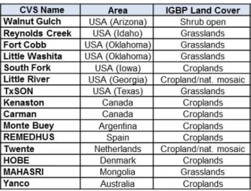
Table 1. Global Core Cal/Val Sites
2. CALIBRATION / VALIDATION APPROACHES
During SMAP’s post-launch calibration/ validation phase, the SMAP L2SMP team is focused on (1) calibrating, verifying, and improving the performance of the science algorithms, and (2) validating the accuracies of the L2SMP soil moisture product, especially in light of mission accuracy requirements. These assessments are based on a number of different approaches, including comparisons with ground-based in situ soil moisture measurements from instrumented sites run by SMAP Cal/Val Partners; in situ ground measurements from sparse networks; other satellite-based products, especially SMOS soil moisture; model-based products; and results from dedicated SMAP field campaigns. Although the cal/val efforts presented in this paper focus on comparisons with in situ data from core cal/val sites, it is expected that cal/val evaluations and monitoring using all approaches will continue throughout the SMAP mission lifetime.
In order to assess the quality of the Version 4 L2SMP data, nineteen months of SMAP soil moisture data from March 31, 2015 through October 31, 2016 were compared against locally scaled aggregations of in situ measurements of soil moisture data from fifteen core cal/val sites in the U.S., Canada, Argentina, Europe, Mongolia, and Australia. These sites are listed in Table 1 along
with their associated land cover type. For an instrumented ground site to be considered a SMAP core validation site (CVS), it must have achieved a certain level of maturity which would provide confidence that the collection of point data could be used as representative of the spatial area covered by a SMAP satellite footprint [3]. Factors considered include the geographic distribution of the in situ stations across the site, the number of stations, the calibration of the in situ instruments, and the development of a scaling function to convert the point measurements at the site into an areal average that can be compared to gridded SMAP retrieved soil moisture (default function is a linear average of all stations). The status of other candidate cal/val sites is periodically reviewed to determine if they should be elevated to CVS status. Only the CVS are used in quantitative assessment of SMAP algorithm performance.
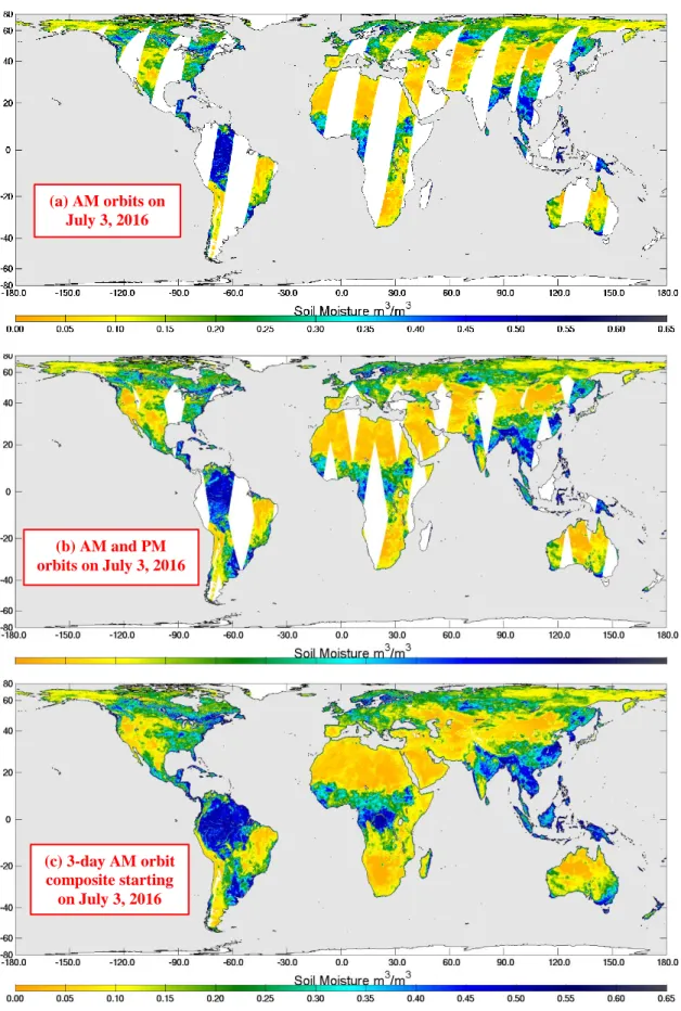
3. ADDITIONAL SOIL MOISTURE RETRIEVALS FROM PM ORBITS The L2SMP product has been expanded in the Version 4 release in December, 2016 to include soil moisture retrievals for the 6 PM (ascending) orbits in addition to the original L2SMP 6 AM (descending) passes. The inclusion of both AM and PM soil moisture data in the standard product now enables faster (~2x) global coverage and diurnal soil moisture monitoring capability. Figure 1a shows SMAP soil moisture retrieved from all the AM orbits on July 3, 2016, while Figure 1b adds in the soil moisture from the PM orbits on July 3, 2016, displaying the increase in global spatial coverage for a single day with both AM and PM orbits. Figure 1c is a 3-day composite of just AM-orbit data which was previously needed to insure complete global coverage with no data gaps. The addition of PM data should cut the time needed for complete global coverage down to ~ 2 days.
4. L2SMP ACCURACY ASSESSMENT Agreements between the SMAP L2SMP data and the cal/val data sets are reported in unbiased root mean square error (ubRMSE), bias, and time series correlation. The ubRMSE captures time-
Figure 1 is an example of SMAP L2SMP soil moisture data. (a) includes soil moisture retrieved from one day of 6 am descending orbits on July 3, 2016; (b) adds the 6 pm orbit data for July 3, 2016; (c) is a 3-day composite of just AM orbits showing complete global coverage.
(a) AM orbits on July 3, 2016 (b) AM and PM orbits on July 3, 2016 (c) 3-day AM orbit composite starting on July 3, 2016
SMAP CVS Accuracy Metrics for March 31, 2015 –
October 31, 2016
ubRMSE (m3/m3) Bias (m3/m3) Correlation
SCAH SCAV DCA SCAH SCAV DCA SCAH SCAV DCA
L2SMP AM data (36-km posting) 0.044 0.037 0.043 -0.033 -0.014 0.010 0.796 0.822 0.738 L2SMP PM data (36-km posting) 0.046 0.039 0.047 -0.037 -0.028 -0.015 0.772 0.795 0.700
Figure 2. Comparisons of 19 months of SMAP L2SMP AM and PM soil moisture with in situ soil moisture measurements from SMAP Cal/Val Partner core sites [4].
random errors, bias captures the mean differences or offsets, and correlation captures phase compatibility between data series.
At the present time, the SMAP Project is still evaluating a number of different soil moisture retrieval algorithms, all based on the tau-omega model, including the Single Channel Algorithm-Horizontal polarization (SCA-H), Single Channel Algorithm-Vertical polarization (SCA-V), and Dual Channel Algorithm (DCA). A description of these algorithms can be found in the SMAP L2/3_SM_P ATBD [2].
As shown in Figure 2, results for nineteen months of SMAP soil moisture examined for the Version 4 data release indicate that the SCA-V currently delivers the best performance of the retrieval algorithms examined. The accuracy of the soil moisture retrievals averaged over the core validation sites was an ubRMSE of 0.037 m3/m3 for the 6 AM data and 0.039 m3/m3 for the 6 PM data, which meets the SMAP mission accuracy requirements of an ubRMSE < 0.040 m3/m3. The slight degradation in the accuracy performance metrics for the 6 PM data compared to the 6 AM data might be expected given that algorithm assumptions that hold true for the AM retrievals might be less valid for the PM data (more Faraday rotation, less hydraulic/thermal uniformity, soil temperature normalization issues, etc.).
6. REFERENCES
[1] Entekhabi, D., E, Njoku, P. O’Neill, K. Kellogg, plus 19 others, “The Soil Moisture Active Passive (SMAP) Mission,” Proceedings of the IEEE, Vol. 98, No. 5, May, 2010. [2] O'Neill, P., E. Njoku, T. Jackson, S. Chan, and R. Bindlish, SMAP Algorithm Theoretical Basis Document:
Level 2 & 3 Soil Moisture (Passive) Data Products. Revision
C, December 15, 2016, SMAP Project, JPL D-66480, Jet Propulsion Laboratory, Pasadena, CA.
[3] Jackson, T., P. O’Neill, E. Njoku, S, Chan, R. Bindlish, A. Colliander, F. Chen, M. Burgin, S. Dunbar, J. Piepmeier, S. Yueh, D. Entekhabi, M. Cosh, T. Caldwell, J. Walker, X. Wu, A. Berg, T. Rowlandson, A. Pacheco, H. McNairn, M. Thibeault, J. Martínez-Fernández, Á. González-Zamora, M. Seyfried, D. Bosch, P. Starks, D. Goodrich, J. Prueger, M. Palecki, E. Small, J. Calvet, W. Crow, and Y. Kerr, November 16, 2015. Calibration and Validation for the L2/3_SM_P
Beta-Release Data Products, Version 2, SMAP Project, JPL
D-93981, Jet Propulsion Laboratory, Pasadena, CA. [4] Jackson, T., P. O’Neill, , S, Chan, R. Bindlish, A. Colliander, F. Chen, S. Dunbar, J. Piepmeier, M. Cosh, T. Caldwell, J. Walker, X. Wu, A. Berg, T. Rowlandson, A. Pacheco, H. McNairn, M. Thibeault, J. Martínez-Fernández, Á. González-Zamora, E. Lopez-Baeza, F. Udall, M. Seyfried, D. Bosch, P. Starks, C. Holifield, J. Prueger, Z. Su, R. van der Velde, J. Asanuma, M. Palecki, E. Small, M. Zreda, J. Calvet, W. Crow, Y. Kerr, S. Yueh, and D. Entekhabi, December 15, 2016. Calibration and Validation for the L2/3_SM_P
Version 4 and L2/3_SM_P_E Version 1 Data Products,
December 15, 2016, SMAP Project, JPL D-56297, Jet Propulsion Laboratory, Pasadena, CA.
![Figure 2. Comparisons of 19 months of SMAP L2SMP AM and PM soil moisture with in situ soil moisture measurements from SMAP Cal/Val Partner core sites [4]](https://thumb-eu.123doks.com/thumbv2/123doknet/14110177.466509/5.918.95.825.82.263/figure-comparisons-months-smap-moisture-moisture-measurements-partner.webp)
