HAL Id: hal-00296806
https://hal.archives-ouvertes.fr/hal-00296806
Submitted on 9 Aug 2005
HAL is a multi-disciplinary open access
archive for the deposit and dissemination of
sci-entific research documents, whether they are
pub-lished or not. The documents may come from
teaching and research institutions in France or
abroad, or from public or private research centers.
L’archive ouverte pluridisciplinaire HAL, est
destinée au dépôt et à la diffusion de documents
scientifiques de niveau recherche, publiés ou non,
émanant des établissements d’enseignement et de
recherche français ou étrangers, des laboratoires
publics ou privés.
Developing natural resource models using the object
modeling system: feasibility and challenges
L. R. Ahuja, J. C. Ascough Ii, O. David
To cite this version:
L. R. Ahuja, J. C. Ascough Ii, O. David. Developing natural resource models using the object modeling
system: feasibility and challenges. Advances in Geosciences, European Geosciences Union, 2005, 4,
pp.29-36. �hal-00296806�
SRef-ID: 1680-7359/adgeo/2005-4-29 European Geosciences Union
© 2005 Author(s). This work is licensed under a Creative Commons License.
Advances in
Geosciences
Developing natural resource models using the object modeling
system: feasibility and challenges
L. R. Ahuja1, J. C. Ascough II1, and O. David2
1USDA-ARS-NPA, GPSRU, 2150 Centre Ave., Bldg. D, Suite 200, Fort Collins, CO 80526, USA 2Colorado State University, Dept. of Civil Engineering, Fort Collins, CO 80523, USA
Received: 1 August 2004 – Revised: 1 November 2004 – Accepted: 15 November 2004 – Published: 9 August 2005
Abstract. Current challenges in natural resource
manage-ment have created demand for integrated, flexible, and easily parameterized hydrologic models. Most of these monolithic models are not modular, thus modifications (e.g., changes in process representation) require considerable time, effort, and expense. In this paper, the feasibility and challenges of us-ing the Object Modelus-ing System (OMS) for natural resource model development will be explored. The OMS is a Java-based modeling framework that facilitates simulation model development, evaluation, and deployment. In general, the OMS consists of a library of science, control, and database modules and a means to assemble the selected modules into an application-specific modeling package. The framework is supported by data dictionary, data retrieval, GIS, graphical visualization, and statistical analysis utility modules. Spe-cific features of the OMS that will be discussed include: 1) how to reduce duplication of effort in natural resource mod-eling; 2) how to make natural resource models easier to build, apply, and evaluate; 3) how to facilitate long-term maintain-ability of existing and new natural resource models; and 4) how to improve the quality of natural resource model code and ensure credibility of model implementations. Exam-ples of integrating a simple water balance model and a large monolithic model into the OMS will be presented.
1 Introduction
The problems facing both developers and users of natural re-source models are becoming increasingly complex. Tremen-dous progress has been made in discovering basic princi-ples in different scientific disciplines that created major ad-vances in management and technology for natural resource systems. However, understanding natural resource man-agement issues related to ecology (habitat restoration), hy-drology (water management), and farming practices (fertil-Correspondence to: J. C. Ascough II
izer and chemical application) become compounded when viewed within the physical, biological, chemical, and geo-logical responses of the natural world. Computer simula-tions for prediction and management of watersheds, water supply areas, and agricultural fields and farms have also in-creased in complexity. The multidisciplinary nature of these problems usually requires accounting for a significant num-ber of different models, data sources, management alterna-tives, and customers/stakeholders. This is particularly true in the case of agriculture where awareness of the general public requires careful management of agricultural systems in order to protect soil, water, and air quality. Simultane-ously, market-based global competition in agricultural goods is challenging the economic feasibility of traditional agricul-tural production systems, and compels development of new and dynamic cropping and management strategies.
It can be argued that achieving the goal of sustainable nat-ural resource management should involve consideration of whole system effects. Unfortunately, most natural resource systems involve highly complex interactions of soil-plant-weather-management components that are extremely diffi-cult to quantitatively describe. Thus, state of the art chal-lenges in optimal management of the natural resources have created demand for integrated, flexible and easy to use mod-eling tools which are able to simulate the quantitative and qualitative aspects of the system (e.g., the hydrologic cy-cle) with a sufficient degree of certainty. Although a myr-iad of models are available, they are typically constrained to the specific scales and purposes they have been developed for and therefore are more robust in some areas than oth-ers (depending on the primary goal guiding their develop-ment). Furthermore, most of these monolithic models are not modular; are very difficult to update, add to, or connect with other models; have diminishing technical support; and lack the flexibility to meet current needs for more integrated analysis of changing natural resource issues.
All of the above reasons indicate a need for a new frame-work of model development that can integrate existing and future natural resource models into a common, collaborative,
30 L. R. Ahuja et al.: Developing natural resource models using the object modeling system and flexible system. Such a system will maintain
modular-ity, reusabilmodular-ity, and interoperabililty or compatibility of both science and auxiliary components. The system will also rec-ognize the fact that different categories of applications may require different levels of scientific detail and comprehen-siveness, as driven by problem objectives, scale of appli-cation, and data constraints. These functionalities of the system will be obtained by establishing standard libraries of interoperable science and auxiliary components or mod-ules that provide the building blocks for a number of sim-ilar applications. Module libraries have been successfully used in several domains, such as the manufacturing, trans-port, and other systems (Breunese et al., 1998; Praehofer, 1996). One of the earliest modular model developments was done for SHE, the European Hydrologic System Model (Ab-bot et al., 1986). Leavesley et al. (1996) reported the conver-sion of the Precipitation Runoff Modeling System (PRMS) to a Unix-based Modular Modeling System (MMS) for hy-drologic modeling. Leavesley et al. (2002) presented some successful applications of this concept. Other examples of model integration framework initiatives include the Interac-tive Component Modelling System (Rahman et al., 2004), Tarsier (Watson and Rahman, 2004), Spatial Modeling En-vironment (Maxwell and Costanza, 1995, 1997), and Har-monIT (Blind and Gregersen, 2004). To summarize, an ap-proach for modeling natural resource systems is needed that will:
– Reduce duplication of development effort, and improve
the quality and currency of model code;
– Make natural resource models much easier to build,
ac-cess, understand, and use;
– Facilitate long-term maintainability of existing and new
natural resource models;
– Lead to greater consistency of modeling for particular
problems and scales;
– Improve response and delivery times in scientific
mod-eling projects;
– Ensure creditability and security of model
implementa-tions; and
– Function on any major computing platform.
The Object Modeling System (OMS) being developed by the USDA-ARS Great Plains Systems Research Unit (Fort Collins, CO) and the USGS (Denver, CO) meets the above criteria. The OMS provides a modular modeling framework which allows the implementation of single- or multi-process modules which can be compiled and applied as custom-tailored model assemblies.
2 Object Modeling System (OMS) Description
2.1 Overview
The OMS project was initiated in 1996 at the Friedrich Schiller University of Jena. In October 2000, the OMS evolved into an interagency project between the USDA-ARS, USGS, and USDANRCS, with financial support from ARS and inkind support from the partners. During the past 36 months, the OMS programming team has completed the de-velopment of most of the core components of the OMS. The OMS vision, described below for initial ARS implementa-tion, is close to being realized (Ahuja et al., 2002):
“The OMS is a computer framework consisting of: 1) a library of science, control, and database modules; 2) a means to assemble the selected modules into a modeling package customized to the problem, data constraints, and scale of application; 3) automatic generation of a userfriendly inter-face; and 4) creation of a compiled, ready-to-run, version of the package. The framework is supported by utility modules such as data dictionary, data retrieval, GIS, graphical visual-ization, and statistical analysis. The framework employs the latest Java-based software technology for all its components. The science modules are also quickly updated or replaced as new knowledge and data become available. The OMS will be supported from a central server for use by all ARS scientists, NRCS specialists, USGS, and other collaborators.”
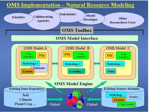
The OMS is built on top of the NetBeans platform. The NetBeans platform is a framework for building desktop ap-plication software in the Java programming language. The OMS leverages NetBeans features such as user interaction components (e.g., menu bars, tool bars, status displays, tabbed-window displays, etc.), storage access components, and help components (e.g., JavaHelp). A schematic of OMS implementation for natural resource modeling is presented in Fig. 1.
2.2 Component Architecture
The general objectives of the OMS project included the de-velopment of generic software tools to extract modules from existing non-modular simulation models, and to incorporate them into the OMS framework with standard OMS descrip-tions. These tools have been developed, but need further test-ing and improvement. The OMS framework has the follow-ing functional components that are currently operational:
1. A module-building component that facilitates the inte-gration of existing (legacy) code into the framework. 2. A module repository containing modules that can be
readily utilized to assemble a working model (types of modules in the library will include science, control, util-ity, assessment, data access, and system modules). 3. A model builder that assembles modules from the
mod-ule library into executable models and verifies data con-nectivity, and compatibility in scale and comprehensive-ness.
Fig. 1. Schematic of OMS implementation for natural resource modeling.
4. A dictionary framework that manages extended model-ing data type information and provides extended seman-tics checking for module connectivity verification. 5. An extensible user interface that facilitates an
appropri-ate user interaction for general model development and application (it is supported by a number of contributing software packages for database management, visualiza-tion, and model deployment).
The components have the following architecture or char-acteristics:
1. OMS models are treated as hierarchical assembled com-ponents representing building blocks. Comcom-ponents are independent and reusable software units implementing processing objects for simulation models. They reside in a model library and are categorized into data access components, science components, control components, utility components, and system components.
2. The OMS is able to integrate legacy code components. By an automated JAVA wrapper generation for legacy code, components written in languages such as Fortran or C++ can be embedded into the OMS at the function level.
3. The “knowledge-backbone” of the OMS is the dictio-nary framework. It enables the OMS to verify state vari-ables and parameters according to scientific nomencla-tures during model development and application. Dic-tionaries are also used to specify parameter sets, model control information and the component connectivity.
They are implemented in the Extensible Markup Lan-guage (XML).
4. The OMS is extensible, i.e., extension packages exist for different aspects in model development and applica-tion. Extension packages are used for visual model as-sembly, model application, an interface to the dictionary framework, output visualization, and GIS integration. 5. The OMS scales from a full-featured, standalone
devel-opment system with tools for model assembly, visual-ization, and analysis to a runtime Web service environ-ment.
For a more complete explanation of the OMS framework and architecture, the reader is referred to David et al. (2002).
3 Developing natural resource models with the OMS: advantages and disadvantages
The following section lists the advantages (Ahuja et al., 2002) and disadvantages of developing natural resource models with the OMS.
3.1 Advantages and feasibility
1. Efficient transfer of technology: For the transfer of natural resource technology tools to stakeholders, re-searchers, and other users, the OMS will serve as a mul-tidimensional platform for integration of various soft-ware tools. The end users will then develop deployment links to only the OMS, rather than develop links to each
32 L. R. Ahuja et al.: Developing natural resource models using the object modeling system of the separate software tools as is current practice. This
will result in a faster transfer of appropriate technology. For example, the USDA-NRCS Information Technol-ogy Center (ITC) in Fort Collins CO, USA has been a partner in OMS development, and is committed to using the OMS as a means to provide technical tools to 2500 field offices for natural resource conservation planning. The NRCS-ITC has already developed links to the OMS for its automated runoff curve number approach. Fi-nally, due to a common model building platform and a common user interface for all models, the OMS will re-sult in reduced start-up time for model development and lower training costs for users.
2. Cost reduction in maintenance and customer support for software technology: It is generally agreed that over the long-term, these items cost up to three times as much as for initial development of the software packages. At present, there are hundreds, if not thousands, of small to large natural resource software programs that need to be maintained and supported. A huge amount of time and labor is being spent on this process since mono-lithic models are becoming very expensive to use, diffi-cult to update, have diminishing technical support, and lack the flexibility to meet todays needs for more inte-grated analysis of natural resource issues. These prob-lems can be overcome if many of the existing pack-ages were transferred to the OMS and all new packpack-ages were developed within the OMS. By using the exist-ing Modular Modelexist-ing System (MMS) (Leavesley et al., 1996) for PRMS (Leavesley et al., 1983) model devel-opment and deployment, the USGS has realized a huge cost savings in maintenance and customer support. The web site http://iscmem.org/Memorandum.htm) lists de-tails of a MOU that eight U.S. federal agencies (NRC, EPA, DOE, COE, USGS, ARS, NRCS, NOAA) have endorsed for the development and deployment of com-mon methods and techniques for platform integration across all agencies.
3. Cost reduction in developing new software technology: In the past, model development efforts have primarily consisted of large teams of scientists. For example, ARS has had a number of individuals and teams build software technology and simulation models, including the erosion models WEPP and WEPS and the water quality models GLEAMS, RZWQM, AnnAGNPS, and SWAT. Each of these packages cost many millions of dollars to develop, including scientist and support time. Development costs were also inflated by significant du-plication of work. Natural resource model developers can now leverage that investment by putting the sci-ence in those packages as modules in the OMS to build new customized software packages at a small fraction of the cost. Preliminary results in the core OMS de-velopment phase on modularization of the existing hy-drologic models RZWQM and PRMS showed a code reduction of 20–33% for OMS model versions while
preserving the same simulation results. In this age of information technology, the demand for such software packages will increase tremendously. In the ARS alone, if we were to develop ten customized large new sys-tem packages to meet this demand over the next ten years, we will save at least $100 million dollars, assum-ing 80% of the science comes from existassum-ing modules already put in the OMS and 20% is new code.
4. Applying the most suitable science for specific prob-lems: The OMS will allow the selection of the best eval-uated and most appropriate science modules currently available depending upon the nature of the problem and required answers, availability of input data, and scale of application. The OMS library may have different mod-ules for a research model versus a management decision tool. Similarly, a watershed-scale management model may possibly require different (i.e., less complex) sci-ence modules than a field-scale model. Issues of di-mensionality (e.g., 1-D surface vs. 2-D groundwater), scale, or dynamic interactions (e.g., feedback mecha-nisms) between modules can be easily handled in the OMS as long as the required module structures and data dependencies are adequately defined.
5. Assure reliability in results from software tools for simi-lar applications: Natural resource software application users often report that different software tools or simula-tion models give vastly different results, say for predict-ing crop yield, because the tools used different science approaches in key process areas. The OMS will signifi-cantly reduce this problem by utilizing evaluated, docu-mented, and standardized modules for the basic science components for a given category of applications. 6. The OMS library as a reference and coordination tool
for future research and development: The OMS library will be a repository of current, quantitative knowledge in different areas of natural resource system science. Future scientists could look to this library to help de-termine where further research and development are needed.
7. Integrated analysis of natural resource system produc-tion and conservaproduc-tion issues: Effective analysis and management of natural resource systems and the envi-ronment requires integration of tools and data types that now exist in an array of individual disparate models. The OMS will provide customized, whole-system tools for the analysis of production and conservation issues (e.g., environmental quality and global climate change management) in natural resource systems.
8. OMS certification mechanism for approved “science building blocks”: The OMS supports the technical cer-tification of library components based on X.509 Certifi-cates and the validation of such certifiCertifi-cates. This will
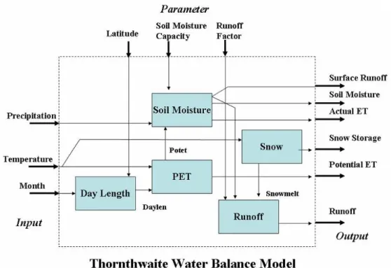
Fig. 2. OMS components and Thorthwaite water balance model assembly.
allow agencies or other entities to certify approved mod-eling components and models. In addition, license pro-tection of modules or components is allowed through signatures within the Netbeans platform.
9. Enhance productivity of scientists and researchers: The customized, best-quality, software tools developed through the OMS will help field scientists quantify their results and transfer them to other soils and climates very rapidly. The gaps identified in the process will make fu-ture research more focused. Overall, the productivity of scientists and the quality of science should increase as focus centers on science module implementation rather than Graphical User Interface (GUI) design, software deployment, packaging and maintenance.
10. International coordination in new science module de-velopment and publication: Through the Internet, the OMS will serve as a common platform for international scientists and researchers to contribute their findings as modules to the OMS library. A supervisory group or or-ganization (e.g., International Association of Hydrolog-ical Sciences) could coordinate this development, and provide a mechanism for peer review and quality con-trol. The module contribution to the library will be considered a publication by scientists that could have world-wide impact.
3.2 Challenges and difficulties
Challenges to using the OMS for natural resource model de-velopment stem from the following problems:
– Lack of motivation to share model code – in order to
ful-fill the intended purpose of the OMS, model developers must build a repository of modules through contribution to the OMS module library.
– Acceptance of a modular coding structure – model
de-velopers must spend more “up-front” time in module development in terms of module structure, I/O require-ments, metadata description, etc.
– Willingness to share data sets for a range of natural
re-source processes covering different climatic and phys-iographic regions across the world – application of nat-ural resource models developed under the OMS will be difficult without data sets for comparison and evalua-tion.
– Loss of model name recognition – this can be overcome,
however, by the development of a mechanism for peer review and quality control of individual modules.
4 Results and conclusions
4.1 OMS integration example: Thornthwaite water balance model
The OMS utilizes Component Oriented Programming (COP) for the creation and execution of simulation models. Compo-nents in general take the idea of object-orientation to a next level. While object-oriented design methods support abstrac-tion and localizaabstrac-tion of data and methods, they can also lead
34 L. R. Ahuja et al.: Developing natural resource models using the object modeling system
Box 1.
/** Latitude of location (degrees) ...
* @oms.default 35.0 * @oms.unit degree angle */
private Attribute.Double latite; /** Day length (s)
* @oms.default 0 * @oms.unit s */
private Attribute.Double daylength; public void execute() {
int month = this.month.getValue();
double latitude = this.latitude.getValue(); double dayl = DAYS[month - 1] - 80.; if (dayl < 0.0)
dayl = 285. + DAYS[month-1]; this.daylength.setValue(dayl);
}
public Attribute.Double getLatitude() {
return latitude;
}
public void setLatitude(Attribute.Double latitude) {
this.latitude = latitude;
}
...
to simulation systems where objects are codependent. To re-move that limitation, a more rigid idea was introduced in the OMS: the component. The key difference between a stan-dard object and a component in the OMS is that a compo-nent is completely replaceable and provides its behavior by having a passive structure. This means that the simulation component is always called from the system, as opposed to the component calling some system functionality. This ap-proach provides the highest degree of flexibility from a mod-eling framework point of view.
This section presents an example of an OMS natural re-source model comprised of small, well-defined components. The Thornthwaite water balance model (Thornthwaite, 1948; Mather, 1978, 1979) uses an accounting procedure to analyze the allocation of water among various components of the hy-drologic system. Inputs to the model are monthly tempera-ture (◦C) and precipitation (mm). Outputs include monthly
potential and actual evapotranspiration, soil moisture stor-age, snow storstor-age, surplus, and runoff (all in mm). The con-nectional structure is shown in Fig. 2. The model consists of five components for (1) computing day length, (2) potential evapotranspiration (PET), (3) soil moisture accounting, (4) snow accounting, and (5) runoff generation.
Each component represents a hydrological process con-cept and the inputs/outputs are well-defined. There is in-ternal data flow between the components, as well as exter-nal available Input and Output slots (Fig. 2). Box 1 shows a code fragment of the Daylen component with the defi-nition of the parameter “latitude” and the output variable “daylen”. The “execute()” method implements the compu-tation of the day length based on current month and latitude. The Daylen component provides accessor methods (e.g., set-Latitude/getLatitude) allowing the OMS to pass data accord-ing to the metadata specifications above each data declara-tion.
Box 2.
– File Setup – Daily Time Loop
– Read Daily Meteorology – Initialize Daily Variables – Determine PET
– Hourly Loop
• Rainfall-Runoff Group
· Green-Ampt Infiltration
· Kinematic Wave Flow Routing
• Water / Chemical Redistribution Group
· Actual Transpiration
· Drain Source/Sink
· Richard’s Equation Redistribution
· Soil Heat Flux
· Nutrient Cycling
· Pesticide Transport
– Finalize Daily Summaries
To run the Thorthwaite water balance model, the OMS connects the input with the system input reader and allows each variable to be plotted as output. The components reside in a “TimeContainer” which handles the monthly iterations based on the input data set.
4.2 OMS Integration Example: RZWQM
As previously stated, creating highly integrated natural re-source simulation models using traditional programming methods can be expensive and time-consuming. This section presents an example of using the OMS to create a new agri-cultural water quality model utilizing component-oriented methods coupled with process-based modules. A large-scale Fortran 77 simulation model, the Root Zone Water Qual-ity Model (RZWQM) (Ahuja, 2000) was disaggregated into smaller components which were then reassembled into a functionally identical model within the OMS. RZWQM in-tegrates physical, biological, and chemical processes to sim-ulate plant growth and the movement of water, nutrients, and pesticides over and through the root zone for a representative unit area of an agricultural field over multiple years. Box 2 shows a simple schematic of the organizational structure of the RZWQM model represented in the OMS to complete the simulations.
A challenge of monolithic model disaggregation is decid-ing at which point in the original code it is reasonable to ex-tract a new section of code into a singular executable com-ponent. This extraction process is typically iterative with the intended result being a module containing a level of com-plexity that makes sense for the intended use. In other words, module size and complexity should be determined by func-tional use, e.g., modules consisting of single algorithms may
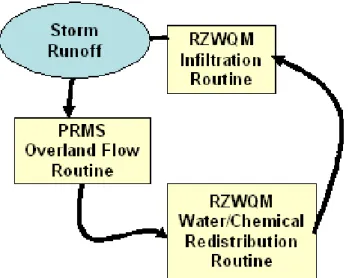
Fig. 3. RZWQM Green-Ampt infiltration routine generates runoff
during a storm event and is passed to the PRMS overland flow routine to drive the kinematic wave solution (if no storm event, a Richards equation based redistribution routine is used).
be appropriate or an entire monolithic model may function as a module. The OMS-based version of RZWQM was then ex-tended with components for runoff and soil erosion to form a new simulation tool to examine water quality assessment at a small watershed scale. Point estimates of rainfall excess (runoff) generated in RZWQM infiltration components were routed through the PRMS-based kinematic wave routine to move the water to the edge of an overland flow plane (Fig. 3). In the future, this runoff/runon water would be simulated for a series of overland flow planes that could then be routed through a channel routing routine to simulate watershed hy-drology. Figure 4 shows the sample output hydrograph in the OMS from a test input rainfall event.
4.3 Concluding Remarks
A large number of complex natural resource system models are currently in use worldwide. Most of these models are based on sound science, but have specialized data require-ments and significant duplication exists in many areas. The current OMS development tool will leverage these sizeable investments of developer time and money to: 1) facilitate an interdisciplinary effort extracting the best scientific routines of existing models; and 2) provide integration and interop-erability of existing and new scientific modules and modern data resources. To summarize, principal advantages of the OMS include:
1. The OMS will increase the probability of using the best science available in various combinations for the given conditions and problem.
2. The OMS will be easier to maintain and update as new knowledge, data and technology become available. The OMS will allow a “select, plug, and play” mechanism
Fig. 4. Results from the OMS simulation show the runoff (cfs)
hy-drograph.
for modules consisting of sub-models, equations, graph-ics, statistgraph-ics, risk analysis, parameter estimation, stan-dard data sources and various reporting formats. 3. New knowledge expressed in the form of modules will
be relatively easy to verify and evaluate (and possibly lead to scientific peer review).
4. The OMS will help to eliminate duplicate functional-ity across natural resource models. The OMS library of modules will serve as a reference and a coordina-tion mechanism for future improvements. The OMS will facilitate communication between model develop-ers by providing a common standard for development and implementation.
5. The OMS should significantly reduce the problem of different natural resource models giving different results by utilizing a library of evaluated, documented, and standardized modules and integrated output options. 6. The OMS will provide a consistent interface for model
creation and evaluation, and will reduce startup time for scientific users and developers.
7. The OMS offers support-ready compliance with the dis-tinct advantage of having a set of application packages (e.g., data input, parameterization, visualization) under
36 L. R. Ahuja et al.: Developing natural resource models using the object modeling system a single user interface or a set of consistent user
inter-faces.
8. The OMS will allow flexibility to choose scientific mod-ules most appropriate for the scale or region of interest, or to respond to other unique influencing factors under consideration.
In conclusion, the component-oriented and modular ap-proach of the OMS and the modules/models implemented in it will provide the basis for more efficient and collaborative model development in the future. This type of integrative and open-source approach is desperately needed in order to solve global challenges impacting natural resource systems such as sustainable management of natural resource systems and the impact of global climate change on natural resource systems. For more details on the OMS project mission, project docu-mentation, or to download the entire application or individual modules, visit the OMS web site at http://oms.ars.usda.gov/.
Acknowledgements. The authors wish to thank I. Schneider and
K. Rojas for their programming support on OMS core model development.
Edited by: P. Krause, S. Kralisch, and W. Fl¨ugel Reviewed by: anonymous referees
References
Ahuja, L. R., Rojas, K. W., Hanson, J. D., Shaffer, M. J., Ma, L. (Eds.): Root Zone Water Quality Model, Water Resources Publi-cation, 2000.
Ahuja, L. R., David, O., Blackburn, W., Amerman, R., Werner, J., Carlson, J., Knighton, R., and Leavesley, G.: The Object Model-ing System (OMS): an advanced object-oriented, modular mod-eling computer technology for agricultural production systems, USDA-ARS Working White Paper, Vers. 1, Fort Collins, CO, 2002.
Abbot, M. B., Bathurst, J. C., Cunge, J. A., O’Connell, P. E., and Rasmussen, J.: An introduction to the European Hydrological System-Systeme Hydrologique Euopeen, “SHE”, 2: structure of a physically-based, distributed modelling system, J. Hydrol., 87, 61–77, 1986.
Blind, M. and Gregersen, J. B.: Towards an Open Modelling In-terface (OpenMI) The HarmonIT project, in: Complexity and Integrated Resources Management, edited by: Pahl-Wostl, C., Schmidt, S., Rizzoli, A. E., and Jakeman, A. J., Transactions of the 2nd Biennial Meeting of the International Environmental Modelling and Software Society (iEMSs), Manno, Switzerland, ISBN 88-900787-1-5, 346–351, 2004.
Breunese, A. P. J., Top, J. L., Broenink, J. F., and Akkermans, J. M.: Libraries of reusable submodels: theory and application, Simu-lation, 77 (1), 7–22, 1998.
David, O., Markstrom, S. L., Rojas, K. W., Ahuja, L. R., and Schneider I. W.: The Object Modeling System, in: Agricul-tural System Models in Field Research and Technology Trans-fer, edited by: Ahuja, L. R., Ma, L., and Howell, T. A., Lewis Publishers, 317–330, 2002.
Leavesley, G. H., Lichty, R. W., Troutman, B. M., and Saindon, L. G.: Precipitation Runoff Modeling System: Users Manual, Wa-ter Resources Investigations 83-4238, USGS, Denver, Colorado, 1983.
Leavesley, G. H., Restrepo, P. J., Markstrom, S. L., Dixon, M., and Stannard, L. G.: The Modular Modeling System (MMS): Users Manual, Open File Report 96-151, USGS, Denver, Col-orado, 1996.
Leavesley, G. H., Markstrom, S. L., Restrepo, P. J., and Viger, R. J.: A modular approach to addressing model design, scale and pa-rameter estimation issues in distributed hydrological modelling, Hydrol. Proc., 16, 173–187, 2002.
Mather, J. R.: The Climatic Water Balance in Environmental Anal-ysis, D.C. Heath and Company, Lexington, Massachusetts, 239 pp., 1978.
Mather, J. R.: Use of the climatic water budget to estimate stream-flow, in: Use of the Climatic Water Budget in Selected Envi-ronmental Problems, edited by: Mather, J. R., Publications in Climatology, 32, 1–52, 1979.
Maxwell, T. and Costanza, R.: Distributed modular spatial ecosys-tem modelling, Int. J. Comp. Simul.: Special Issue on Advanced Simulation Methodologies, 5 (3), 247–262, 1995.
Maxwell, T. and Costanza, R.: A language for modular spatio-temporal simulation, Ecol. Modell., 103 (2,3), 105–114, 1997. Praehofer, H.: Object oriented, modular hierarchical simulation
modeling: towards reuse of simulation code, Simul. Pr. Theory, 4 (4), 221–234, 1996.
Rahman, J. M., Seaton, S. P., and Cuddy, S. M., Making frame-works more useable: using model introspection and metadata to develop model processing tools, Env. Modell. & Soft., 19 (2004), 275–284, 2004.
Thornthwaite, C. W.: An approach toward a rational classification of climate, Geographical Review, 38, 55–94, 1948.
Watson, F. G. R and Rahman, J. M.: Tarsier: a practical soft-ware framework for model development, testing, and deploy-ment, Env. Modell. & Soft., 19 (2004), 245–260, 2004.