Publisher’s version / Version de l'éditeur:
Vous avez des questions? Nous pouvons vous aider. Pour communiquer directement avec un auteur, consultez la
première page de la revue dans laquelle son article a été publié afin de trouver ses coordonnées. Si vous n’arrivez pas à les repérer, communiquez avec nous à PublicationsArchive-ArchivesPublications@nrc-cnrc.gc.ca.
Questions? Contact the NRC Publications Archive team at
PublicationsArchive-ArchivesPublications@nrc-cnrc.gc.ca. If you wish to email the authors directly, please see the first page of the publication for their contact information.
https://publications-cnrc.canada.ca/fra/droits
L’accès à ce site Web et l’utilisation de son contenu sont assujettis aux conditions présentées dans le site LISEZ CES CONDITIONS ATTENTIVEMENT AVANT D’UTILISER CE SITE WEB.
Roger J.E. Brown Memorial Volume. Proceedings Fourth Canadian Permafrost
Conference, pp. 23-35, 1982
READ THESE TERMS AND CONDITIONS CAREFULLY BEFORE USING THIS WEBSITE.
https://nrc-publications.canada.ca/eng/copyright
NRC Publications Archive Record / Notice des Archives des publications du CNRC :
https://nrc-publications.canada.ca/eng/view/object/?id=914a0691-6c2e-463c-ad9a-45b530f047e9 https://publications-cnrc.canada.ca/fra/voir/objet/?id=914a0691-6c2e-463c-ad9a-45b530f047e9
NRC Publications Archive
Archives des publications du CNRC
This publication could be one of several versions: author’s original, accepted manuscript or the publisher’s version. / La version de cette publication peut être l’une des suivantes : la version prépublication de l’auteur, la version acceptée du manuscrit ou la version de l’éditeur.
Access and use of this website and the material on it are subject to the Terms and Conditions set forth at
The influence of terrain factors on the distribution of permafrost bodies
in the Chic-Choc Mountains, Gaspesie, Quebec
National Research
Conseil national
'1
*
Council Canada
de recherches Canada
THE INFLUENCE OF TERRAIN FACTORS ON THE DISTRIBUTION OF PERMAFROST BODIES IN THE CHIC-CHOC MOUNTAINS, GASPESIE, QUEBEC
b y J.T. Gray and the late R.J.E. Brown
Reprinted from
B m G .
gr-5.
The Roger J.E. Brown Memorial Volume
I
! f!?2,2?ty
"
-Proceedings Fourth Canadian Permafrost Conference I
Calgary, Alberta, March 2 - 6, 1981
i
E:'-
31-
1 3
p. 23-
35 1 ,1
r r n- c -
-,.,-
1 I . .1
7 . ,. * 1 ' 1 I L - I < - , - -I --_ DBR Paper No. 1073Division o f Building Research
OF PERMAFROST BODIES IN THE CHIC-CHOC MOUNTAINS, GASPESIE, QUEBEC
J.T. GRAY ANDTHE LATE R.J.E. BROWN
Reprinted from/Rtimpression de
THE ROGER J.E. BROWN MEMORIAL VOLUME Proceedings Fourth Canadian Permafrost Conference Comptes Rendus de la Quatrieme ConfCrence Canadienne sur le Pergelisol
Calgary, Alberta, March 2-6 mars 1981 National Research Council of Canada Conseil National de Recherches du Canada
The influence of terrain factors on the distribution of permafrost bodies in the
Chic-Choc Mountains, GaspCsie, QuCbec
J.T. GRAY
Departement de Ggographie, Universiti de Montr&al, Que., Canada AND
the late R.J.E. BROWN
Division of Building Research, National Research Council of Canada, Ottawa, Ont., Canada Ground temperature studies revealed the presence of several contemporary bodies of discontinuous permafrost on the windswept treeless summits of the Chic-Choc Mountains in Gaspesie. One such per- mafrost body on Mont Jacques-Cartier is 45 to 60 m thick and related to a mean annual ground sur- face temperature of - 1 to - 1.5"C. Snow cover is the principal terrain factor governing the presence
or absence of permafrost. Snow depth indices derived from long-term data from a similar climatic region in central Quebec-Labrador permitted the Mont Jacques-Cartier permafrost to be plotted on the basis of snow cover. The rapid increase in snow depth as one crosses from the tundra into the kriimmholz zone enabled a close correlation to be made between the permafrost boundary and the tree-line and this facilitated regional mapping of permafrost bodies thoughout the Chic-Choc Moun- tains. This correlation is not perfect, however. First, local tree-lines occur below the critical altitude at which the mean annual air temperature is sufficiently low to induce the development of permafrost, either due to local lithologic, microclimatic, or geomorphological conditions. Secondly, in the tundra zone large topographic hollows on the leeward side of summits harbour a deep winter snow pack which inhibits permafrost development. Thirdly, below the regional tree-line, lenses of permafrost occur in rock glaciers at the base of steep slopes. In one case, an ice lens 5 to 10 m thick was observed during excavations at the toe of the rock glacier.
Des etudes de la temperature du sol ont rtvele la presence de plusieurs poches de pergelisol discon- tinu sur les sommets sans arbres balayes par les vents des monts Chic-Choc en GaspCsie. Une de ces masses de pergtlisol sur le mont Jacques-Cartier atteint une Cpaisseur de 45 a 60 m alors que la tem- perature moyenne annuelle de surface y est de - 1 a - 1,5"C. La couverture nivale est le principal fac-
teur dont depend la presence ou I'absence de pergelisol. Des indices d'epaisseur de neige, dtrivis de donnees portant sur de longues periodes pour une region climatique comparable dans le centre du QuCbec et du Labrador, ont permis de determiner I'ttendue de pergelis01 du mont Jacques-Cartier en fonction de la couverture nivale. L'tpaisseur de neige augmentant rapidement entre la zone de toundra et la zone de krummholz, on a pu etablir une etroite corrdation entre la limite du pergelis01 et la limite des arbres, qui a facilite la cartographie rkgionale des Ctendues de pergdisol dans l'ensemble des monts Chic-Choc. Cette correlation n'est toutefois pas parfaite pour trois raisons: premitrement, il existe des limites des arbres locales a des altitudes infirieures a I'altitude critique a laquelle la temperature annuelle moyenne de I'air est assez peu Clevee pour qu'il y ait formation de pergelisol en raison des caractkristiques lithologiques, micro-climatiques ou gComorphologiques locales; deuxitmement, dans la zone de toundra de grandes depressions situkes du cBtt sous le vent des sommets subissent en hiver un enneigement important qui emptche la formation de pergClisol; enfin, on trouve, en-deqa de la limite regionale des arbres, des lentilles de pergelisol dans les glaciers rocheux a la base des pentes raides. Dans un cas on a trouve pendant des travaux d'excavation, une lentille de glace de 5
a
10 m a la base d'un glacier rocheux.Proc. 4th Can. Permafrost Conf. (1982)
Introd yction
Despite the relative accessibility of the Chic-Choc Mountains and the numerous field studies of glacial geomorphology in the region over the past 100 years, there has been little discussion of the periglacial land- forms and even less mentibn of the possible existence of permafrost or perennially frozen ground. This, despite the cold climate and treeless nature of the highest summit domes and plateaux. Passing refer- ence was made by McGerrigle (1952) to the probably widespread distribution af permafrost in the eastern Chic-Choc Mountains
(b
the vicinity of MontJacques-Cartier). However, McGerrigle was actually able to prove the existence of frozen ground at only one location.
"This was close to the base of the valley wall east of the Salmon Branch of Grand Cascapedia River where the Bathurst Company Road turns to cross the branch. Here, talus from adjacent cliffs lies under a cover of moss and scrubby tree growth. The upper four feet of the talus deposit was too tightly bound by frost (August 1944) to be removed by bulldozer. The depth of the frozen ground is not known. The eleva- tion is 975 feet" (McGerrigle 1952, p. 49).
24 4TH CAN. PERMAFROST CONF. (1982) 1
Subsequently de Romer (1977), while commenting and tree-line throughout the Chic-Choc region is ' on periglacial features such as stone nets and stripes examined.
near the summit of Mont Jacques-Cartier in the east- ern Chic-Choc Mountains, and on rock glacier-like
lobes and semi-permanent snow banks on several of The Study Area
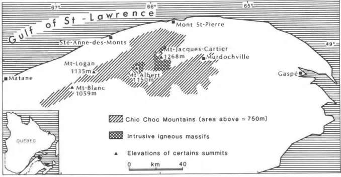
the eastern slopes, indicated that he was "reasonably The Chic-Choc Mountains form the backbone of
,
sure that there are no large areas of perennially frozen the northern Gasp6 Peninsula (Figure 1). The area of ground". No positive proof for the validity of this high summits, exceeding 900 m, extends for 80 km statement is brought forward by de Romer, however, from the vicinity of Matane to the eastern front of the although he did state that the periglacial environment McGerrigle massif. The mountain range follows the with its frost-generated features could reflect cold cli- Appalachian structural trend from WSW to ENE and mates without necessarily implying permafrost. is for the most part composed of Cambrian to Devo- During separate visits to the summit of Mont nian rocks of sedimentary and volcanic origin, in- Jacques-Cartier, the present authors were struck by truded locally by magmatic material. The largest of the treeless nature of the plateaux, resembling very these intrusions, at the eastern end of the range, is the closely the tundra and rock desert surfaces of north- McGerrigle pluton, composed in part of granitic and ern Canada underlain by contemporary permafrost. in part of hybrid rocks, particularly syenite, monzo-'
They were also impressed by the periglacial features nite, and granodiorite. A second intrusive mass, of in the summit regions and subsequently undertook peridotite composition, forms the Mont Albert mas- studies of the groundtemperature regime which now sif and the Chic-Choc Range proper, to the west of establish the existence of contemporary permafrost Mont Albert.bodies on a number of these summits (Gray and Topographically the McGerrigle Mountains con- I
Brown 1979). sist, in reality, of a large interior plateau at an altitude
The present paper defines the various thermal of 900 to 1100 m from which several summit domes parameters of one such permafrost body on Mont rise to altitudes of about 1200 m. Mont Jacques- Jacques-Cartier and attempts to relate the permafrost Cartier, the highest summit in south-eastern Canada, distribution on a regional basis to various terrain fac- attains an elevation of 1268 m. The Mont Albert mas- tors, principally snow cover. Finally, since the opera- sif is a large undulating plateau ranging in elevation tion of these terrain factors is somewhat influenced from 900 to 1150 m. The Chic-Choc Range proper, to by the nature of the vegetation cover through micro- the west, consists of a succession of dome-like sum- climatic effects, the relationship between permafrost mits rising to 900 to 1100 m from the broad interior
w 65'=
7
Chic Choc Mountains ( a r e a above
-
7 5 0 m l Intrusive igneous massifsA Elevations of certains summits
FIGURE 2. Kriimmholz zone on east flank of Mont Jacques- Cartier. Note the stone stream in the foreground. The turf embank- ment beyond the terminus of the feature is an indicator of gravita- tional movement of the boulders downslope.
plateau described by McGerrigle (1952) as the Gasp6 Upland. The highest of these summits is Mont Logan situated at 1130 m. Topographic contrasts are accen- tuated by glacial erosion, which has carved out large cirques and steep-sided valleys on the margins of the highland massifs.
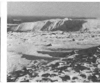
The Tree-line in the Chic-Choc Mountains Previous permafrost studies have placed considera- ble emphasis on the role of forest and shrub growth with respect to permafrost distribution and develop- ment, through their effects on snow cover and radia- tion input in summer (Brown 1966; Ives 1974, 1979). Some comments are therefore in order, concerning the altitude and character of the tree-line in the high mountains of GaspCsie. Studies by Boudreau and Payette (1974) in the Mont Jacques-Cartier area have demonstrated that a climatically controlled transition from a subalpine forest dominated by white spruce (Picea glauca) to an alpine tundra takes place through a transitional zone of kriimmholz. The transitional zone, which extends from about 1000 to 1100 m, is characterized by very tightly packed stands of stunted white spruce (Picea glauca) and black spruce (picea mariana). As one moves from the true forest to the true tundra, individual stands become increasingly isolated and individual trees more stunted (Figure 2). In the true alpine tundra, the clumps of kriimmholz are very sparsely distributed, covering less than one per cent of the terrain. Despite the absence of trees, the surface cover in the tundra zone is very varied, depending to a large extent on the nature of
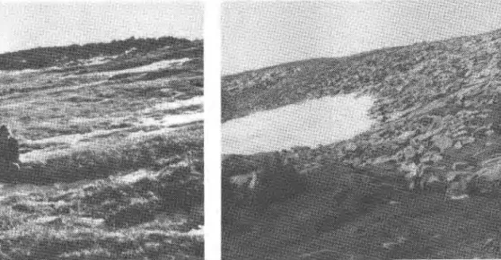
FIGURE 3 . Frost-shattered bedrock in the tundra zone on the east flank of the summit dome of Mont Jacques-Cartier.
the surface sediment cover. Large areas consist of coarse frost-shattered debris with a sparse moss and lichen cover (Figure 3). Where a finer grained sedi- ment mantle exists, grasses and flowering plants grow, albeit, subject to disturbance associated with frost churning in the soil. In the more humid depres- sions characterized by late-lying snow patches, a con- tinuous turf cover has been able to develop, giving true alpine meadow characterized by various herba- ceous species (Figure 4).
The Mont Albert massif is characterized bv a dramatic transition from forest cover to an alpine tundra at 1000 m near the north rim of the plateau. The sharp transition with no change of altitude, the relationship to a lithological boundary between amphibolite to the north and peridotite to the south, and the generally low elevation of the transition, compared with the Mont Jacques-Cartier area, indi- cates that climate alone is not responsible for the tree- line. The high concentrations of olivine in the soils of the peridotite zone are toxic to tree growth, suggest- ing that an edaphic contrast is the main reason for the sharp transition from forest to tundra. As a result most of the plateau of Mont Albert is treeless.
In the western zone, very few summits attain the climatically controlled tree-line and most are covered by dense, almost impenetrable, kriimmholz. The tun- dra zone is reached only on the highest and steepest summit domes such as Mont Logan.
In all three zones in the high mountains of GaspC- sie, another treeless situation may occur locally, where contemporary or recent geomorphological processes have inhibited colonization by vegetation. Such areas are found generally on and below glacially
I
26 4TH CAN. PERMAFROST CONF. (1982)
I
steepened slopes characterized by cliffs and coarse ture of - 4.5"C is thereby obtained for the latter debris accumulations such as talus cones and rock summit for the decade 1963 to 1973. It can be con-
glaciers. cluded that the mean annual air temperatures of the
Gaspesian summits in the tundra zone are within the
Climate approximate range of - 3 to - 5°C.
Climatic records for this mountainous region are Gagnon's maps (Gagnon 1970) indicate a total sparse and of short duration. The Meteorological annual precipitation of more than 1600 mm for the Service of the Ministkre des Richesses Naturelles du summits above 1100 m and an annual snowfall in QuCbec studied the regional climate of the western excess of 6250 mm. The snow cover lasts for 260 to Chic-Choc Mountains between 1966 and 1969 by 290 days, disappearing between the 15th and 30th of locating numerous semi-automatic stations at various June. The plateau surfaces above the tree-line are altitudes (Gagnon 1970). Apart from these records, windswept in the winter and snow accumulation is there are data of varying quality from a few isolated relatively small. Snow surveys were carried out on the stations throughout the mountainous region. This summit dome of Mont Jacques-Cartier by a group includes records for the summit of Mont Jacques- from the UniversitC de MontrCal in the springs of Cartier (1268 m) between 1943 and 1945, compiled by 1978 and 1979, which were years of successively very the Canadian Armed Forces and cited in Boudreau high and very low snow accumulation in the region. and Payette (1974); for the summit of Mont Logan Average snow depths in these two years were 66 and (1 135 m), 55 km to the west, between 1963 and 1973; 38 cm respectively. Individual values ranged from a ' for the Mines de la Madeleine (850 m), 10 km to the few centimetres to 120 cm for 64 sample points in the west, between 1974 and 1977; and for Murdochville two years, variations within each year's sample popu- (550 m), 40 km to the east, between 1952 and 1976. lation being mainly due to topographic irregularities Among the most significant elements from the and to contrasts in aspect. Despite these variations, point of view of the ground temperature regime, may the difference between the snow accumulation in the be cited temperature and precipitation parameters, two years is statistically significant at a confidence particularly mean annual air temperature and the level of 99.9 per cent. On the moderate to steep slope build-up of snow cover. The mean annual air temper- on the eastern, leeward side of the summit ridge, ature for Mont Jacques-Cartier for 1943 t o 1945 was snow annually accumulates to a depth of several - 3°C. If one takes into account the mean adiabatic metres, and may occasionally persist through the lapse rate of 0.6"C/100 m, calculated very accurately summer season into the following winter, as was the for the region by Gagnon (1970), it is possible to , case in 1977 (Figure 5). Below the tree-line the ,
extrapolate the Mont Logan data to the summit of kriimmholz and subalpine forest are characterized by Mont Jacques-Cartier. A mean annual air tempera- a thicker snow cover than was observed for the sum-
FIGURE 4. Alpine meadow at 1150 m on the eastern slope of FIGURE 5. A late spring snow patch on the east slope of Mont Mont Jacques-Cartier. This zone is subject to an annual snow accu- Jacques-Cartier, 70 m below the summit. This patch survived the mulation of 3 m. 1977 summer season but disappeared in 1976, 1978, and 1979.
mit of Mont Jacques-Cartier in the tundra zone. An eleven-point transect carried out over a distance of 300 m in the Lac a RenC area, 2 km north of the sum- mit, at an elevation of about 1125 m, in the spring of 1979, gave snow depths ranging from 95 to 235 cm, with a mean depth of 150 cm.
Field Programme
In September 1977, a hole 22 mm in diameter was drilled through 3 m of weathered bedrock, and a fur- ther 27 m into the underlying competent bedrock at a site close to the summit of Mont Jacques-Cartier. A multi-thermistor cable 30 m long was installed in the freshly completed water-filled hole, and readings were taken at the time of the installation and through- out the summers of 1978, 1979, and 1980.
A second 30-m cable was installed in a well 15 cm in diameter near the summit of Mont Logan, in the same month, and readings have been taken at inter- vals since the installation. In addition, sporadic tem- perature readings were obtained with flexible cables and rigid probes in old drill holes on Mont Notre- Dame, Mont Jacques-Cartier, and Mont Albert.
Thermal conductivity and heat production analyses were carried out on core samples by A.S. Judge, Earth Physics Branch, Department of Energy, Mines and Resources, Ottawa.
In an effort to relate the thermal data to snow dis- tribution, in order to determine the probable bounda- ries of permafrost bodies on Mont Jacques-Cartier, snow surveys were carried out in April 1978 and 1979. In addition, the late-winter thermal regime to the base 1 of the snow pack was ascertained for three contrast-
1
, ing sites.
I Findly, the surfaces of three rock glaciers were
I examined For signs of recent activity and the presence
or absence of ice bodies which would reveal the pres- ence of sporadic permafrost we11 below the regiond tree-line.
I
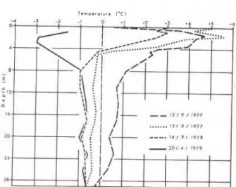
Derivation of Significant Geothermal Parameters Temperature profiles have been obtained on twelve occasions over the two-year interval since cable instal- lation at the summit of Mont Jacques-Cartier. To date, all readings have been obtained for spring, sum- mer, and fall conditions, with the exception of two late-winter readings, obtained in April 1979 and March 1980.Four of these temperature profiles (Figure 6) I clearly demonstrate the presence of a permafrost body at the summit of Mont Jacques-Cartier. The
1
drilling process appears to have caused minimal dis- turbance, and a rapid return to thermal stability isTcm.cr.l"rc l D C l
FIGURE 6 . Temperature profiles in the 30-m drill-hole at the sum- mit of Mont Jacques-Cartier.
indicated by the convergence of the lower parts of the profiles. The wide variations in the top few metres of the profiles (with the exception of two profiles logged immediately after the cessation of the drilling opera- tion), are related to seasonal temperature fluctuations at the surface.
Analysis of all the available data permits definition of several important thermal parameters, which can then be used to derive conclusions on the thickness of the permafrost and the associated active layer, as well as on its spatial extent and contemporaneity. These parameters are the depth of zero annual amplitude, the geothermal gradient, and the mean annual ground surface temperature.
The depth of zero annual amplitude is difficult to estimate precisely due to the limited precision of the temperature bridges used, even when frequently cali- brated ( k 0.1 "C), and due to the lack of winter data, but available logs indicate that 11 to 14 m represents a reasonable approximation. This is a rather shallow depth for bedrock but the insulative role of 3 m of frost-shattered bedrock with the contained voids and fines must be borne in mind.
The geothermal gradient may be calculated directly from the temperature data, or it may be derived indi- rectly from a number of geothermal parameters. The direct approach simply graphs observed ground tem- peratures against depths (Figure 7), for the section of the profile XY beyond the depth of zero annual amplitude, revealing a geothermal gradient of 17"C/km (or 0.017 K/m). In the indirect approach, the geothermal gradient must be derived from avail- able estimates of the geothermal flux in the Appala- chian structural province, and from analysis of the thermal conductivity of the local bedrock.
T e m p e r a t u r e s ( O C )
Profile constructed from mean of a l l valid observations in 1978-79
...
;.ii.:....
_
Envelope of theoretically.
-
derived profilesFIGURE 7. Geothermal gradients for the Mont Jacques-Cartier drill-hole between 1 1 and 29 m.
The geothermal flux is the heat flow from the mantle through the crustal rocks to the surface, sup- plemented by heat production due to radioactive decay of elements within the crustal rocks. Broad limits of 48 to 64 mW/m2 for the geothermal flux for the Appalachian structural province can be estimated
-
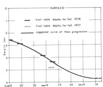
l r o s l ~ u b l e depth for 1.11 1978....
frost toble drprh, fo* full 19772
!I
.
r u g Q a l s d c u r v e o l thaw progressionFIGURE 8. Active layer progression during the fall of 1978 at the summit of Mont Jacques-Cartier.
from data compiled by Hyndman et al. (1979) given measured heat production values of 1.97 W/m3 for a core sample from the Mont Jacques-Cartier drill-hole (Figure 8). Thermal conductivity values for core sam- ples of the crystalline bedrock from the Mont Jacques-Cartier drill-hole range from values of 2.47-2.95 W/m
.
K with a mean value of 2.65 W/m.
K.The geothermal gradient is then calculated by dividing the estimated geothermal flux (in mW/m2) by the measured thermal conductivity of samples (in W/m
.
K) (Judge 1973).With the given ranges of values for thermal con- ductivity and geothermal flux, maximum and mini- mum values for geothermal gradient are 26 and 16"C/km respectively.
This indirectly derived range of geothermal gra- dients when plotted linearly (see Figure 7) shows a general correspondence with the directly observed temperature gradient. The small-scale fluctuations evident in the latter are the result of small cumulative shifts in ground surface temperatures in a positive or negative sense over time spans exceeding one year, and are, perhaps, also the result of unrecorded varia- tions in thermal conductivity.
A mean annual ground surface temperature below O°C, measured over several years, is critical for the existence of contemporary permafrost. It was felt that, if this parameter could be estimated for the sum- mit of Mont Jacques-Cartier, reasonable projections to lower altitudes, using statistically determined lapse rates, could then form a basis for establishing lower altitudinal limits of permafrost for similar terrain conditions.
at the cable site, coupled with the lack of winter data
1
do not permit direct calculation of the mean annualI
ground surface temperature. Furthermore, the latter cannot be derived indirectly from air temperature data due to the absence of detailed information onI microclimatic factors such as albedo, snow cover,
1
and evapotranspirative effects on heat exchange. 'The only recourse, therefore, is to the subsurface temperature data. The previously determined mean, maximum, and minimum geothermal gradients for the lower section of the drill-hole may reasonably be extrapolated upwards to the surface through the zone subject to seasonal temperature fluctuations. If no correction to these gradients is made to allow for a change in thermal conductivity associated with the
3 m of frost shattered debris at the surface, maxi- mum and minimum values of - 1.1 and - 1.4"C are obtained (see Figure 7). If allowance is made for a reduction in thermal conductivity by a very liberal estimate of 50 per cent for this highest zone due to an entrapped mixture of air, fine debris, and moisture, the values suffer an insignificant reduction of about 0.1 "C. Thus, within reasonable error limits, a mean annual ground surface temperature of
-
1 to - 1 3 ° C can be assessed for the summit plateau of Mont Jacques-Cartier. This range of values is 2 to 3.5"C higher than the mean annual air temperatures for the site derived earlier in this paper.f
Thickness of the Active Layer and the Contemporary Permafrost
Temperature observations taken through the fall of 1978 indicate downward progression of the thaw zone to a depth of almost 6 m in late October (see Fig- ure 8). The surprising element here is the relatively rapid late fall progression of the thaw front, despite the small positive, and sometimes negative, heat flux into the ground after early September. The explana- tion is probably to be found in the passage of the thaw front in the fall, from frost-shattered bedrock, with a fine sediment fraction and a moderate ice con- tent, into competent bedrock, with a very low mois- ture content. The phase change from ice to water then becomes of insignificant importance in absorbing latent heat, and hence in retarding penetration of the thaw front. No fall readings were available after late October and so 6 m represents only a reasonable minimum value for the active layer thickness at the site.
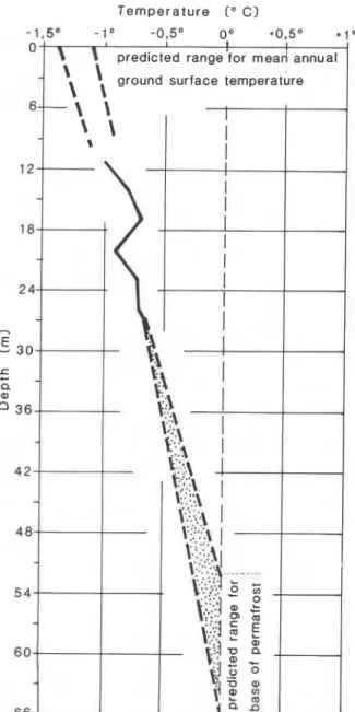
Reasonable values of 52 to 65 m for the base of the permafrost are obtained when the indirectly derived geothermal gradients are linearly extrapolated down- wards from the observed temperature at the base of
Temperature ( O C)
-1.5'
predicted range for mead annual
'
\
ground surface temperatureFIGURE 9. Extrapolation of geothermal gradients downwards to the base of the permafrost body and upwards to the ground surface for the Mont Jacques-Cartier site.
the hole (Figure 9).
Undoubtedly some error is introduced into such extrapolations due to perturbations in the tempera- ture profiles related to recent climatic change or to variations in thermal conductivity. However available climatic data from nearby Murdochville shows no evidence of a cumulative shift in air temperatures or snowfall values and, by implication, in ground sur- face temperatures over the last 25 years. This is cer- tainly valid evidence in support of the suggested line-
arity of the temperature gradients for the upper few tens of metres at the Mont Jacques-Cartier site, well beyond the range of extrapolation to the suggested permafrost base. Thermal conductivity variations over such a short vertical range are also likely to be slight as there are no major lithological discontinui- ties in the vicinity of the drill-hole.
Thus, from information on the active layer depth and the permafrost base it can be concluded that Mont Jacques-Cartier permafrost body has a thick- ness beneath the plateau summit of 45 to 60 m.
The available evidence indicates clearly that the permafrost is contemporary and not relict in nature. In the first place, the permafrost table is only about
6 m below the surface. If the permafrost body had developed only in response to a colder phase than that prevailing at the present day (such as during the his- torically recent "little ice age") thermal diffusivity of the bedrock would have been sufficiently great for a rapid descent of the permafrost table, far beyond 6 m, within only a few decades of the onset of a warming trend. In the second place, the mean annual surface temperature of - 1 to - 1.5OC deduced above for the site, and the mean annual air temperature of
- 3 to - 5"C, clearly support the conclusion that the present day climate favours contemporary perma- frost on the summit plateau.
Spatial Distribution of Permafrost in the Chic-Choc Mountains in Relation to
Climatic and Terrain Factors
If the adiabatic lapse rate of 0.6"C/100 m is used in association with the derived mean annual surface temperature at the summit of Mont Jacques-Cartier to assess the lower limits of permafrost in the Chic Choc Mountains, a hypothetical altitude of 1000 to 1100 m above sea level is obtained. This would per- mit the existence of many small permafrost bodies but would be a valid conclusion only for surfaces where terrain factors resemble very closely those of the Mont Jacques-Cartier summit plateau.
Indeed for the GaspCsie summits, where mean annual air temperatures are only marginally below O°C, the presence or absence of contemporary per- mafrost at a given site becomes mainly a function of the specific micro-climatic conditions induced by various terrain factors. The latter include aspect, topography, vegetation cover, soil cover, and winter snow cover. Whilst not in a position to evaluate quantitatively the role of all those factors on the annual heat budget it is clear that the variability in thickness of the snow cover is largely responsible for lateral variations and indeed discontinuities in perma-
Non-Permafrost Conditions in Treeless Zones
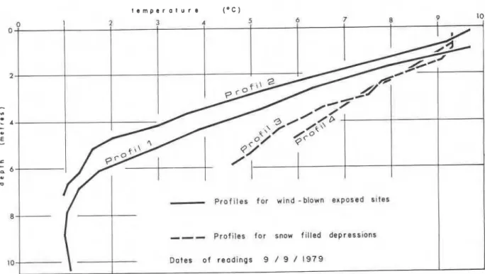
With regard to non-permafrost conditions in tree- less zones, the summit plateaux of Mont Jacques- Cartier and Mont Albert illustrate the range of possi- bilities that exist. The summit dome of Mont Jacques- Cartier in relation to a proposed permafrost boun- dary is shown in Figure 10. The surface conditions of the plateau are maintained with considerable uni- formity in a long, narrow zone extending from NNE to SSW, but elevations drop off rapidly towards the ESE, where an important lee situation, favourable to a very deep winter snow cover, exists just below the summit dome. In March 1980, the acumulation at- tained a maximum depth of 4 m. The zone of heavy snow accumulation favours higher sub-nival winter temperatures. In fact, the profiles (Figure 11) suggest late winter ground temperatures only barely below 0°C when the seasonal cold wave would be expected to have penetrated to the base of the snow pack. The snow depth obviously far exceeds the critical depth for permafrost. This critical depth has still to be cal- culated for the site, but, based on studies by Nichol- son (1979) carried out in the climatically similar pla- teau region north-west of Schefferville, a depth of about 0.75 to 1 m may be sufficient to cause taliks provided that the topographic hollows are sufficiently large in their lateral dimension.
The aspect and moderate inclination of this south- eastern flank of Mont Jacques-Cartier also favour relatively high ground temperatures in summer frost bodies. Windswept surfaces such as those of the Mont Jacques-Cartier summit plateau are not usually
,
very extensive and exhibit considerable topographic contrasts around the margins, leading to an insulative,
snow blanket of variable thickness. An even more important cause of snow cover variations is the rapid altitudinal transition from tundra through kriimm- holz to forest vegetation. As cited earlier, snow depths increase rapidly, three- to four-fold, as one passes below the tree-line. It therefore seems reason- able at first glance to use the tree-line as an index to aid in the regional mapping of permafrost distribu- tion, rather than simply relying on the given altitude of 1000 to 1100 m derived from ground temperature at a single site.Caution is required, however, in such an exercise. Permafrost mapping using the tree-line cannot be car- ried out indiscriminately without regard for local topographical and geological conditions. In some in- stances these conditions suggest that non permafrost zones exist above the local tree-line. In other in- stances, on the contrary, small permafrost bodies appear to exist well below the tree-line.
' I ~ A ~ M O H 'snonupuo3 dla~!ye~ai sauro3aq zloywurnly (.unzuzuo~ .s~ad) auaded dq paleae3xa 'daap ur p
ay] alaym aug e 8uo1e (01 a m 8 y aas) pa3e.u uaaq sey l!d e jo aseq aylolly8p a3! pun018 JO a3uasqe IeJol
6.1epunoq lsoqew~ad ay] sadop u1alsa~-ylnos pue ayL 'apnl!l~e y%!y sl! a~!dsap 'auoz s!yl uroq luasqe ' u ~ a ) s a ~ - q l ~ o u 'ulaypou pasodxa alow ay] . I O ~ dpeap s! ~ s o q e u r ~ a d ' s n y ~ '(lawurns ale1 lo p!ur I!lun
Temperature (OC) Snow Denslty Hardneea Stratigraphy g/cm3 g/c ,712 - l z O -ao - L o 0' 0 I I F r e s h snow
- - -
-
- - 0 . 2 2 3500 3 5 0-
1 Ground surface-
I c e l a y e lFIGURE I I . Temperature profiles and stratigraphy of the snow
pack at site C in a topographic hollow to the east of the summit of Mont Jacques-Cartier on March 20th, 1980.
t e m p e r a t u r e ( * C )
Jacques-Cartier massif, the permafrost boundary was traced well above the local tree-line. This is because these slopes are characterised by a rather mobile and coarse-textured regolith which does not permit rapid colonisation by vegetation. This consideration is a valid one, of course, for all steep slopes throughout the Chic-Choc Mountains.
The plateau of Mont Albert illustrates in striking fashion the existence of a large treeless area, extend- ing well below the permafrost boundary of 1000 to 1100 m established from the Mont Jacques-Cartier data. On Mont Albert the tree-line is situated some 200 m below the regional tree-line on account of the toxic effect on tree vegetation of the local olivine-rich bedrock. Temperature profiles obtained for four old drill-holes in a col at 1000 m between the north and south summits (Figure 12) indicate that permafrost is absent on the lower part of the plateau. Widespread permafrost does probably exist, however, at the high- est altitudes on the plateau, beneath the wind-blasted south summit, at 1 150 m.
Permafrost Islands in the Forest Zone.
With regard to the existence of permafrost islands in the forest zone, well below the tree-line, the authors considered the case of coarse boulder accu- mulations at the base of steep slopes, in glacially carv- ed cirques and valleys, and identified a number of
FIGURE 13. Rock glacier like accumulation below the north- facing slope of one of the cirques on the eastern margins of the McGerrigle massif, approximately 4 km to the north of Mont
Jacques-Cartier .
these debris accumulations as rock glaciers (Figures 13 and 14). They were initially built up by rock-falls, avalanches, debris flows, and debris creep and per- haps, in some instances, as lateral moraines in the late glacial and postglacial period. The lobate form of the rock glaciers and the fact that they frequently extend out over the cirque floors suggests that they have been quite active in the Holocene period.
Reconnaissance studies carried out on three of these rock glaciers in the summer of 1980 provided several indications that permafrost lenses, either relict or contemporary in nature, exist in the interior of many of these debris accumulations.
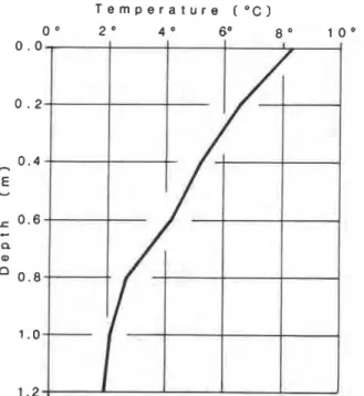
The toe of one of these rock glaciers, is situated at only 250 m in altitude on the east side of the Cascape- dia Valley on the Trans-GaspCsie highway. A large ice lens about 5 to 10 m thick was exposed in 1979 by a Quebec Ministry of Transport excavation in the front. By the summer of 1980, the ice lens had melted back and was no longer visible. A short temperature profile obtained in late July, however, in the inter- stices between boulders at the base of a thermokarst hollow on the rock glacier surface suggests the proxi- mity of a frozen body to the surface (Figure 15). This discovery of a thick ice body at such a low altitude substantiates McGerrigle's discovery of frost-bound talus at an elevation of only 297 m, alluded to at the beginning of this paper (McGerrigle 1952). It is also very interesting in the light of the recent discovery, through deep drilling by Hydro-Quebec personnel, of a thick zone of buried interstitial ice in a rock glacier
FIGURE 14. Surface of rock glacier on the east side of the Casca-
pedia Valley on the Trans-Gaspe Highway. The temperature profile
(see Figure 15) was obtained at the bottom of the thermokarst hol- low in the foreground.
at 540 m in the Parc des Laurentides, north of QuC- bec City (Grumich and Thibeault 1979).
In the case of the two other rock glaciers located at a much higher altitude (about 800 m), permafrost islands are even more likely to be present although deep excavations are not available to reveal the evi- dence. Except in one instance where buried ice was
T e m p e r a t u r e
r o c )
-
FIGURE 15. Temperature profile in the interstices between
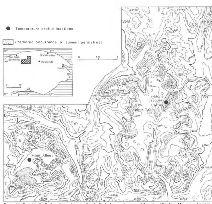
observed within 2 m of the surface and might have Permafrost Map of the Chic-Choc Mountains been seasonal, the evidence for ice bodies is circum- Despite these topographical~y and lithologically Stantid. It is tied to indices of recent activity. induced irregularities, the climatically controlled tree- ' Variability of the forest cover and lichen cover on the line does give a reasonable idea of regional perma- Surfaces reveal that Some Zones are more active than frost distribution (Figure 16). The Alpine permafrost others. In places, sharp Contrasts in lichen Cover COr- in the Chic-Choc Mountains is obviously very discon- responding to topographic breaks SUggest overriding tinuous in nature. Because the individual permafrost of older lobes by lobes active more recently. Excava- bodies are relatively thin, never exceeding the thick- tions in the toe of the rock glacier (see Figure 13) ness of 60 m predicted for Mont Jacques-Cartier, revealed recent lichen kill on boulder surfaces and spatial transitions from non-permafrost to perma- boulders which had clearly been overturned by recent frost conditions are likely to be very rapid, reflecting advance of the rock glacier toe. very faithfully the topographic and vegetation transi-
tions visible at the surface.
T e m p e r a t u r e profile locations
Predicted o c c u r r e n c e o f summit p e r m a f r o s t
Permafrost Elsewhere in the Appalachian Region
Whilst the Chic-Choc Mountains probably possess the most extensive and thickest bodies of permafrost in the Appalachian region, other summits in New England and in Newfoundland protrude above the tree-line, and a few of those summits may be under- lain by permafrost. In New England, this is definitely the case for Mount Washington, in the Presidential Range of the White Mountains of New Hampshire, which attains an elevation of 1915 m. There, the mean annual air temperature is - 2.8"C, and below- freezing temperatures were measured at considerable depths in a deep well drilled at the summit (Howe 1971). Mount Katahdin in Maine, and Mount Marcy, in the Adirondack Mountains in New York State, the only two other \mountain areas of New England which attain elevations in excess of 1500 m, are, nonetheless, 300
m
below the altitude of Mount Washington, and permafrost probably does not underlie their summits. In Long Range, in western Newfoundland, initial measurements of ground tem- peratures have been obtained by Brookes and Brown(pers. commun.) for a drill-hole 18 m deep at an ele-
vation of 550 m. Ground temperatures decreased steadily with depth to 1.5"C at the base of the drill- hole, suggesting that the freezing point may be very closely approached at slightly greater depths, and therefore, that the highest summits, at altitudes of almost 800 m, may be underlain by permafrost.
Conclusion
A permafrost body, approximately 60 m thick, underlies the summit of Mont Jacques-Cartier in the Chic-Choc Mountains, GaspCsie. Temperature meas- urements and heat production and conductivity data, available to a depth of 29 m, indicate that the perma- frost is contemporary and that a mean surface tem- perature of - 1 to
-
1 .5"C can be estimated. The alti- tude, extent, and probable form of the permafrost body on Mont Jacques-Cartier was outlined on the basis of temperature lapse rates and terrain factors. This type of analysis was then applied throughout the region, leading to a map of the treeless summits of the eastern Chic-Chocs which are potentially underlain by permafrost. For such exposed situations, 1000 to 1100 m appears to be the critical lower limit for extensive permafrost. Sporadic areas of thin perma- frost do exist below the regional limit, in several coarse debris accumulations or rock glaciers, at sites receiving little insolation because of their northerly aspect or their situation at the base of deeply incised valleys.Acknowledgements
This research was funded by research grants from the Natural Sciences and Engineering Research Council of Canada, by the Alma Mater Fund of the UniversitC de Montreal, and by the Ministkre de
ducation ion
du Quebec. Money for the drilling opera- tion on Mont Jacques-Cartier was made available from the Division of Building Research of the Na- tional Research Council in Ottawa. Thanks are ex- tended to personnel of the Parc de la GaspCsie, in particular to Robert Castonguay, Robert PichC, and Jacques Bertrand for their assistance with the logis- tical aspects of the research. Finally, mention must be made of the assistance in the field afforded by Guy Bourduas, Bernard HCtu, Louis B. Lafrenikre, Jean Poitevin, Bernard Lauriol, Jacques Dupont, Sylvie Lefebvre, Richard Laurin, and Nathalie Ferron, all graduate or undergraduate students in the Dtparte- ment de Geographie, UniversitC de MontrCal.References
BOUDREAU, F. ET PAYETTE, S. 1974. Le mont Jacques-Cartier, Parc de la Gaspesie, De toute urgence, Quebec. vol. 5, no. 1, pp. 3-18.
BROWN, R.J.E. 1966. Influence of vegetation on permafrost. In:
Proc. 1st Int. Conf. on Permafrost, Nat. Acad. Sci. Nat. Res. Counc. Pub. 1287, pp. 20-25.
DE ROMER, H.S. 1977. Region des Monts McGerrigle. Rapport geo- logique no. 174, Min. des Richesses Naturelles, QuCbec, 233 p. GAGNON, R.M. 1970. Climat des Chic-Chocs. M.P. 36, Servicede la Meteorologic, Min. des Richesses Naturelles, Quebec, 103 p. GRAY, J.T. AND BROWN, R.J.E. 1979. Permafrost presence and dis-
tribution in the Chic-Choc Mountains, GaspCsie, Quebec. Geogr. Phys. Quat., vol. 33, nos. 3-4, pp. 299-316.
GRUMICH, J. ET THIBEAULT, L. 1979. Projet Lac Louis - centrale a reserve pompbe: Investigation geologique 1977-78. Rapport du Service de geologie et geotechnique, Hydro-Quebec, Place Dupuis, Montreal.
HOWE, J. 1971. Temperature readings in test bore holes. Mount Washington Observatory News Bull., vol. 12, no. 2, pp. 37-40. HYNDMAN, R.D., JESSOP, A.M., AND JUDGE, A.S. 1979. Heat flow
in the Maritime Provinces of Canada. Can. J . Earth Sci., vol. 16, no. 6, pp. 1154-1165.
IVES, J.D. 1974. Permafrost. In: Arctic and Alpine Environments. Ives, J.D. and Barry, R.G. (eds.), Methuen, London, pp. 159-194.
.
1979. A proposed history of permafrost development in Labrador-Ungava. Geogr. Phys. Quat., vol. 33, nos. 3-4, pp. 233-244.JUDGE, A.S. 1973. The prediction of permafrost thickness. Can. Geotech. J. vol. 10, no. 1, pp. 1-1 1.
MCGERRIGLE, J.W. 1952. Pleistocene glaciation of Gaspe Penin- sula. Trans. Roy. Soc. Can., vol. 66, series 11 1, pp. 37-51. NICHOLSON, F.H. 1979. Permafrost spatial and temporal variations
near Schefferville, Nouveau-Quebec. Geog. Phys. Quat., vol. 33, nos. 3-4, pp. 265-278.