AbstrAct
A map-view palinspastic restoration of tectonic units in the Alps, carpath-ians and Dinarides reveals the plate tectonic configuration before the onset of Miocene to recent deformations. Estimates of shortening and extension from the entire orogenic system allow for a semi-quantitative restoration of translations and rotations of tectonic units during the last 20 Ma. Our res-toration yielded the following results: (1) the balaton Fault and its eastern extension along the northern margin of the Mid-Hungarian Fault Zone align with the Periadriatic Fault, a geometry that allows for the eastward lateral extrusion of the Alpine-carpathian-Pannonian (ALcAPA) Mega-Unit. the Mid-Hungarian Fault Zone accommodated simultaneous strike-perpendicu-lar shortening and strike-slip movements, concomitant with strike-parallel ex-tension. (2) the Mid-Hungarian Fault Zone is also the locus of a former plate boundary transforming opposed subduction polarities between Alps (includ-ing Western carpathians) and Dinarides. (3) the ALcAPA Mega-Unit was affected by 290 km extension and fits into an area W of present-day budapest in its restored position, while the tisza-Dacia Mega-Unit was affected by up to 180 km extension during its emplacement into the carpathian embayment.
(4) the external Dinarides experienced Neogene shortening of over 200 km in the south, contemporaneous with dextral wrench movements in the internal Dinarides and the easterly adjacent carpatho-balkan orogen. (5) N–s conver-gence between the European and Adriatic plates amounts to some 200 km at a longitude of 14° E, in line with post-20 Ma subduction of Adriatic lithosphere underneath the Eastern Alps, corroborating the discussion of results based on high-resolution teleseismic tomography.
the displacement of the Adriatic Plate indenter led to a change in subduc-tion polarity along a transect through the easternmost Alps and to substantial Neogene shortening in the eastern southern Alps and external Dinarides. While we confirm that slab-pull and rollback of oceanic lithosphere subducted beneath the carpathians triggered back-arc extension in the Pannonian basin and much of the concomitant folding and thrusting in the carpathians, we propose that the rotational displacement of this indenter provided a second important driving force for the severe Neogene modifications of the Alpine-carpathian-Dinaridic orogenic system.
1. Introduction
1.1 Plate tectonic setting
the Alps, carpathians and Dinarides form a topographically continuous, yet highly curved orogenic belt, which bifurcates and encircles the Pannonian basin. they are part of the much larger system of circum-Mediterranean orogens (Fig. 1). De-spite such a continuous topographic expression, this orogenic system is characterised by dramatically diachronous deforma-tion stages along-strike. Its various parts comprise different paleogeographic domains, and major thrusts have opposing
polarity (schmid et al. 2008): in the Western and Eastern Alps as well as in the carpathians thrusts face the European fore-land, whereas in the southern Alps and the Dinarides thrusts face the Adriatic foreland. In a pioneering article, Laubscher (1971) suggested that the Alps and the Dinarides owe their different structural facing to opposing subduction polarities. Deep reflection seismic profiling and seismic tomography have since shown that the western and central segments of the Alps are underlain by a south-dipping lithospheric slab, attributed to subducted European lower lithosphere (schmid et al. 1996, 2004a; schmid & Kissling 2000), whereas the Dinarides and Hellenides are underlain by a northeast-dipping lithospheric
A map-view restoration of the Alpine-carpathian-Dinaridic system for
the Early Miocene
K
amilU
staszewsKi1,*, s
tefanm. s
chmid1, B
ernhardf
ügenschUh1,2, m
atthiast
ischler1,**,
e
dUardK
issling3& w
ims
paKman4Key words: tectonics, kinematics, palinspastic restoration, Alps, carpathians, Dinarides, Adriatic plate
1661-8726/08/01s273-22 DOI 10.1007/s00015-008-1288-7 birkhäuser Verlag, basel, 2008
swiss J. Geosci. 101 (2008) supplement 1, s273–s294
1 Institute of Geology and Palaeontology, bernoullistrasse 32, University of basel, cH-4056 basel. 2 Institute of Geology and Palaeontology, University of Innsbruck, A-6020 Innsbruck.
3 Institute of Geophysics, EtH Hönggerberg, cH-8093 Zürich, switzerland. 4 Faculty of Geosciences, Utrecht University, NL-3508 Utrecht, Netherlands.
*corresponding author, now at: Department of Geosciences, National taiwan University, No. 1, sec. 4, roosevelt road, taipei, 10617 taiwan. E-mail: [email protected], tel: +886-2-2363 6450 #205
slab (e.g. Wortel & spakman 2000; Piromallo & Morelli 2003) south of 44° N.
recent studies suggest that a northeast-dipping “Adriatic” lithospheric slab of about 200 km length also underlies the Eastern Alps in the area east of the Giudicarie and brenner Fault (Lippitsch et al. 2003; Kissling et al. 2006). schmid et al. (2004b) and Kissling et al. (2006) tentatively proposed that this slab is a remnant of Palaeogene orogeny in the Dinarides, which impinged onto the Alps during the Neogene by a combi-nation of northward motion of the Adriatic plate indenter and dextral wrench movement along the Periadriatic Fault. this was a speculative assignment, however, since there is no geo-physical evidence for a continuous, northeast-dipping Adriatic lithospheric slab between the Eastern Alps and the Dinarides north of 44° N (Piromallo & Morelli 2003; this study).
In this contribution we present in map-view a palinspastic res-toration of the substantial displacements and rotations the vari-ous tectonic mega-units of the Alpine-carpathian-Dinaridic oro-genic system underwent during the last 20 Ma (e.g. balla 1987), providing better insight into their early Neogene configuration. We propose that the Mid-Hungarian Fault Zone (Fig. 2) origi-nated from a transform fault, across which the subduction polarity changed from the Alpine to the Dinaridic polarity. Furthermore, our restoration implies c. 200 km of N–s shortening between the Adriatic and European plates, in line with the estimated length of the northeast-dipping slab (Lippitsch et al. 2003). this suggests that this slab represents Adriatic lithosphere that was subducted since the early Neogene. based on this interpretation, we discuss possible reasons for the current discontinuity of the northeast-dipping slab between the Eastern Alps and the Dinarides.
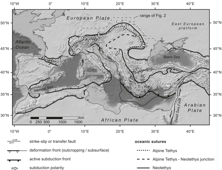
Fig. 1. Overview of the circum-Mediterranean orogenic belt with the positions of present-day deformation fronts and subduction zones (modified after cavazza et al. 2004). traces of oceanic sutures in the Eastern Mediterranean are modified after stampfli & borel (2004), in the Alps, carpathians and Dinarides after schmid et al. (2004b, 2008), in the Pyrenees after Dewey et al. (1973). topography and bathymetry are from the EtOPO5 dataset (NOAA, 1988). continental shelf areas are light grey (less than 2000 m water depth); areas of thinned continental or oceanic crust are dark grey (greater than 2000 m water depth). subduc-tion polarities are only shown for the range of Fig. 2.
10°W 10°W 0° 0° 10°E 10°E 20°E 20°E 30°E 30°E 40°E 40°E 30°N 30°N 35°N 35°N 40°N 40°N 45°N 45°N 50°N 50°N 0 250500 1000 1500km
deformation front (outcropping / subsurface) strike-slip or transfer fault
active subduction front subduction polarity oceanic sutures
Atlantic
Ocean
Black Sea E a s t E u r o p e a n p l a t f o r mA f r i c a n P l a t e
E u r o p e a n P l a t e
A r a b i a n
P l a t e
Alboran Sea Ap en nin es Ap en nin es A l p s A l p s range of Fig. 2 Betics HighAtla s Pyrenees Betics Tyrrhenian Sea Taurides Pontides Dea dS ea Fau lt Greater Caucasus Bitlis-Za gros HighAtla s C a r p a t h ia n s Pyrenees Alpine TethysAlpine Tethys - Neotethys junction Neotethys Din arid es - H e lle n id es Din arid es - H e lle n id es C a rp ath o-Balkan C a rp ath o-Balkan
43°
47° Dalmatian Zone
Budva-Cukali Zone
Pre-Karst & Bosnian Flysch Unit
Dacia Mega-Unit
Tisza Mega-Unit Prebalkan, Danubian, Helvetic, Brianconnais Inner Balkanides
Ceahlau-Severin Valais, Rhenodanubian, Magura Pieniny Klippen Belt Piemont-Liguria, Kriscevo, Szolnok, Sava obducted
W
estern
Vardar ophiolites
& Meliata obducted Eastern
Vardar ophiolites
Ophiolites, suture zones, oceanic accretionary prisms
Miocene external thrust belt
Neogene displacements in km
white lines: outlines of the Pannonian &
Transylvanian basin
European plate Adriatic plate Southern
Alps
High Karst Unit
East Bosnian-Durmitor
Jadar-Kopaonik, Drina-Ivanjica & Bükk
Thrust sheets derived from
Adriatic plate Alps & W est Carpathians ALCA PA Mega-Unit
northern margin of Meliata, Lower
Austroalpine &
Tatric
Eoalpine high-pressure belt
southern margin of Meliata
external foredeep Undeformed foreland Budapest Kosice Debrecen Bucharesti Pitesti Bacau Cernovcy Cluj Beograd W ien Bratislava Krakow Skopje Dubrovnik Zagreb Trieste Sarajevo Verona Munich Milano Sofia Burgas Neotethys Alpine Tethys Alpine Tethys - Neotethys junction Dinarides
shortening extension strike-slip extension, this study
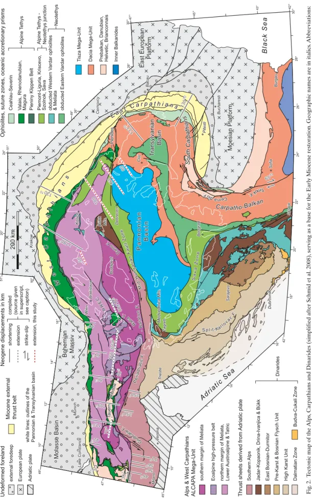
compiled (source given in superscript, see caption)
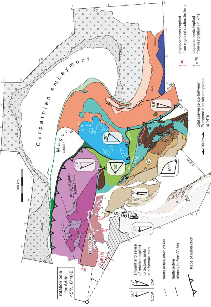
B la ck S ea Adria tic S ea S p l it-Karlo vac F. Tim okF . Cer na -Jiu F. -B al at o n F. M id -H un ga ri an F au lt Z on e Giudicarie F. Bohemian Massiv Darno F. East European Platform Transylvanian Basin Pi en id es E as t C a r p a t h i a n s S ou thC ar pa th ia ns Sa va Zo ne W e s t C a rp at hi an s Per iadr iatic F. Moesian Platform Bükk Mts. Tauern Medvednica Mts. Lake Constance R R E C P a n n o n ia n B a s in window Ra ba F. Molasse Basin Carpatho-Balkan Carpatho-Balkan 180 150 50 80 180 150 >180 9 >180 9 130 10 133 10 130 10 6511 50 80 30 2 507 507 72 6 566 566 46 6 86 3 643 166 total 3 40 3 109 3 113 3 42 3 15 1 20 5 75 4 80±10 8 80±10 8 Fig . 2. t ectonic map of the Alps , c arpathians and Dinarides (simplified after schmid et al. 2008), serving as a base for the Early Miocene restoration. Geographic names are in italics . Abbreviations: F. = fault, Mts . = mountains , rr E c = r aba r iver extensional corridor . t he estimates on the magnitude of Neogene (post-20 Ma) displacements (in km) were derived from the following sources given in superscripts: 1) schmid et al. (1996), 2) Grasemann & Mancktelow (1993), 3) Frisch et al. (1998), 4) Fügenschuh et al. (1997), 5) Genser & Neubauer (1989), 6) schönborn (1992, 1999), 7) Nussbaum (2000), 8) tari (1996), 9) r oca et al. (1995), 10) r oure et al. (1993), 11) Fügenschuh & schmid (2005). s ee F ig
. 4 regarding extension estimates in the Pannonian
b
1.2 Previous work
the eye-catching oroclinal architecture of the Alps, carpath-ians and Dinarides has since long inspired map-view deformations that improved our understanding of the pre-col-lisional plate tectonic assemblage (e.g. channell & Horváth 1976). burchfiel (1980) demonstrated that many of the con-tinental fragments involved underwent significant shortening during the Mesozoic to cenozoic convergence of Europe and the Apulia/Adria promontory. However, the substantial exten-sion, which the ALcAPA (csontos & Vörös 2004; schmid et al. 2008) and tisza-Dacia mega-units underwent in the Late cretaceous (Froitzheim et al. 1997) and particularly in the Neogene during their emplacement into the carpathian em-bayment, remained unaccounted for. As a mega-unit we define an assembly of tectonic units, which as a whole has a common paleogeographic origin that is distinct from adjacent tectonic units or other mega-units, from which it is separated by faults. In contrast to a microplate, its original lithospheric underpin-nings are either lacking or unknown. Hence, this definition is a somewhat more loose definition of a terrane, which implies that a crustal allochthon was separated from its own litho-spheric mantle underpinnings via accretion to a larger plate. Also, the term mega-unit complies with its frequent usage in the regional geological literature (see e.g. Haas 2001; Haas & Pero 2004).
based on paleomagnetic data, balla (1987) showed that the ALcAPA and the tisza-Dacia mega-units north and south of the Mid-Hungarian Fault Zone, respectively, floor the area that is presently occupied by the Pannonian basin (e.g. csontos & Nagymarosy 1998; tischler et al. 2007). starting in the late Early Miocene, these fragments experienced opposed sense rotations during their emplacement into the carpathian embayment (see Fig. 7 in balla 1987). subsequent palinspastic restorations (e.g. royden & baldi 1988; csontos et al. 1992; csontos 1995; Fodor et al. 1999; csontos & Vörös 2004) generally built on balla (1987). Many of these studies took paleomagnetic constraints on the rotations of tectonic units rather quantitatively into ac-count, whilst the translation and concomitant deformation of these units was only qualitatively treated.
Another set of palinspastic restorations aimed at restor-ing tectonic units based on the quantification of shortenrestor-ing amounts derived from balanced cross sections or from restor-ing offsets along major strike-slip faults. two such examples are Frisch et al. (1998) and Linzer et al. (2002), who provided a palinspastic restoration of the Eastern Alps for Late Oligocene to Miocene times. roure et al. (1993), Ellouz & roca (1994), roca et al. (1995), Morley (1996) and behrmann et al. (2000) provided estimates of amounts of shortening in the carpathian thrust belt based on balanced cross-sections. Except for Mor-ley (1996), however, most previous studies did not consider the system of the Alps-Dinarides-carpathians and the Pannonian basin in its entirety and hence failed to link its evolution to the role played by the rigid Adriatic indenter during Miocene to recent times.
2 Rationale for a 20 Ma restoration
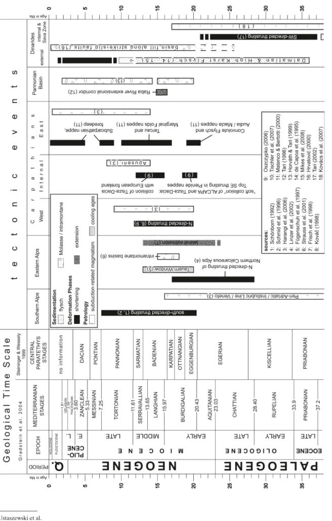
We aim at a semi-quantitative palinspastic restoration of the Early Miocene tectonic configuration, based on a recently compiled new tectonic map (Fig. 2) of the Alpine-carpathian-Dinaridic orogenic system (schmid et al. 2008). We chose the 20 Ma timeframe for our restoration, as this time roughly cor-responds to the onset of numerous interrelated tectonic events (Fig. 3), which are briefly reviewed in the following.
1) the E-directed lateral extrusion (escape and concomitant extension) of the Austroalpine units into the Pannonian basin (ratschbacher et al. 1991) lasted from about 23 to 13 Ma according to Frisch et al. (1998). A younger (20 Ma) age for the time of onset of this event was inferred from mineral cooling and fission track ages obtained across low angle normal faults that exhumed Lower Austroalpine and Penninic series during this extrusion (e.g. the age of the brenner normal fault; von blanckenburg et al. 1989; see also Fügenschuh et al. 1997 and references therein). this is roughly in line with the 18–15 Ma age range of Ottnangian to badenian sediments that accumulated in intra-montane pull-apart basins associated with conjugate strike-slip faults, which evolved during the eastward escape of the Eastern Alps (strauss et al. 2001; Linzer et al. 2002 and references therein).
2) shortening in the southern Alps started between 20 and 17 Ma, i.e. contemporaneously with the sinistral offset of the Periadriatic Fault by the Giudicarie Fault system (schönborn 1992, 1999; schmid et al. 1996; stipp et al. 2004) and lasted until the Messinian. the major shortening in the external southern Alps occurred during serravallian-tor-tonian times (14–7 Ma). by contrast, thrusting of the Aus-troalpine nappes onto the North Alpine Foreland Molasse basin had practically ended at around 17 Ma (Linzer et al. 2002 and references therein).
3) back-arc-extension and related sedimentation in the rift- and wrench-related troughs of the Pannonian basin com-plex started in Eggenburgian to Ottnangian times (bérczi et al. 1988; Nagymarosy & Müller 1988; Horváth & tari 1999), i.e. between 20.5 and 17.5 Ma in the time scale of steininger & Wessely (1999).
4) Neogene thrusting in the external flysch belt of the West carpathians (royden 1988) reached the Dukla and silesian units of the West carpathians by Early burdigalian (Eggen-burgian) times (Kováč et al. 1998; Oszczypko 2006), i.e. at about 20 Ma. In the East carpathians, thrusting also initi-ated at around 20 Ma in the most internal units of the Mol-davides (convolute flysch and Audia-Macla nappes) but reached more external flysch units only by Late burdigalian times, i.e. at around 17 Ma (săndulescu 1988; Matenco & bertotti 2000). some authors invoke along-strike younging of orogenic activity (e.g. Jiříček 1979) that supposedly cor-relates with a general decrease of the ages of calc-alkaline magmatism in the internal carpathians and the Pannonian
basin from west towards southeast (e.g. seghedi et al. 1998; Harangi et al. 2006). In any case, thrusting continued longer in the East carpathians (Matenco & bertotti 2000). the formation of this most external thrust belt made up of flysch sediments was associated with subduction of a retreating lithospheric slab underneath an upper plate formed by the ALcAPA and tisza-Dacia mega-units, including the previ-ously accreted Magura flysch, that started at around 20 Ma. Note that earlier thrusting affected more internal units only; we discuss here the onset of Neogene thrusting that started to propagate into the external flysch belt and which is widely accepted as being contemporaneous with back-arc extension in the Pannonian basin (e.g. royden 1988; Kováč et al. 1998).
5) In the Early burdigalian (20.5–18.5 Ma) sE-directed thrust-ing also initiated in more internal units of the carpathians and led to the formation of the Pienide nappes (northern romania) due to the collision of the ALcAPA and the tisza-Dacia mega-units (săndulescu 1988; tischler et al. 2007). this thrusting occurred during the initial stages of emplacement of the ALcAPA and tisza-Dacia mega-units into the carpathian embayment and was contemporaneous with their soft collision with the European foreland across the external flysch belt (Márton et al. 2007).
2.1 Premises for Early Miocene palinspastic restoration
the Early Miocene restoration was performed with respect to a fixed European foreland under the following premises: 1) changes to the geometric configuration of tectonic units
were applied only to those that underwent significant exten-sion or bending around vertical axes during the timeframe under consideration (20–0 Ma), namely the ALcAPA and tisza-Dacia mega-units.
2) In areas of shortening the outlines of tectonic units, which are separated by major thrusts were left unchanged. conse-quently, gaps opening between the restored and actual posi-tion of such individual units permit to assess the amount of shortening those areas underwent during the last 20 Ma. 3) the foreland was considered as non-deformed, thus
retain-ing a fixed geometric configuration. the undeformed Eu-ropean foreland (including the external foredeep) served as a fixed reference frame, the position of which remained unchanged. based on geological arguments it was assumed that the Adriatic Plate behaved as a rigid block that was subjected to translation and rotation only.
4) Magnitudes of shortening, extension and strike-slip dis-placements were compiled from published sources (Figs. 2 and 4). these data underlay our basic palinspastic restora-tion of the area of interest. such data are strictly distin-guished from deformations that had to be applied for pure 2-D compatibility reasons in areas that are not or ill-con-strained by data. to a large extent the latter are a result of our restoration.
5) rotations were applied to tectonic units only as required from the following map-view geometric and kinematic ar-guments: (i) along-strike shortening gradients, (ii) restora-tion of displacements along curved strike-slip faults and (iii) geometric adjustments to the regional strike. We emphasise that paleomagnetically constrained rotations were not con-sidered as input to our restoration, except for a few small blocks. this was done deliberately in order to test whether a purely kinematic approach yields results that are qualita-tively compatible with the paleomagnetic data (e.g. Márton et al. 2003, 2007).
2.2 Database
Our palinspastic restoration of the Alpine-carpathian-Dina-rides domain (Figs. 2 and 6) integrated the results of a number of earlier published studies to which we refer below. For the Alpine part of the ALcAPA Mega-Unit we used the restora-tion by Frisch et al. (1998), which we combined with data from burkhard & sommaruga (1998), Fügenschuh et al. (1997), Genser & Neubauer (1989), Grasemann & Mancktelow (1993), Gratier et al. (1989), Lickorish & Ford (1998), Philippe et al. (1996), ratschbacher et al. (1991), schmid et al. (1996), schön-born (1992, 1999), Nussbaum (2000) and stipp et al. (2004). Es-timates on the magnitude and direction of extension in the east-ern (Pannonian basin) part of ALcAPA were mainly adopted from tari (1996), and also from Fodor et al. (1998) and szafián et al. (1999). In addition, we used the crustal thinning factor map for the Pannonian basin by Lenkey (1999) to estimate the magnitude of extension affecting the ALcAPA and tisza parts of the Pannonian basin. For the West carpathians, we took the restorations by roure et al. (1993), roca et al. (1995), Morley (1996) and behrmann et al. (2000) into consideration for esti-mating the total shortening that was achieved in the Miocene external thrust belt. these data permitted us to constrain the position of the most external edge of ALcAPA. Furthermore, we used the restorations by tischler (2005) and Márton et al. (2007) for restoring the boundary area between the ALcAPA and tisza-Dacia mega-units.
concerning the tisza-Dacia Mega-Unit we incorporated a restoration of the south carpathians bend zone that was pro-posed by Fügenschuh & schmid (2005) and that is essentially based on data by balla (1987), berza & Draganescu (1988), berza & Iancu (1994), Kounov et al. (2004), Kräutner & Krstić (2006), Matenco et al. (1997, 2003), Moser (2001), Patrascu et al. 1994, schmid et al. (1998) and săndulescu et al. (1978). Fügen-schuh & schmid (2005) retro-deformed the tectonic unroof-ing of the Danubian window as well as strike-slip movements along the curved cerna-Jiu and timok faults, which delimit the “mobile” tisza-Dacia Mega-Unit against the stable Moesian promontory. However, this part of our restoration does not fully constrain the Early Miocene location of the frontal tip of the tisza-Dacia Mega-Unit, since the westernmost part of this unit underwent contemporaneous stretching during its dis-placement into the carpathian embayment. therefore we used
Fig
. 3.
t
imetable illustrating major Neogene tectonic events in the
Alpine-c
the restoration by Morley (1996) in order to anchor the frontal tip of the extending tisza-Dacia Mega-Unit.
Note that no pre-existing reconstructions or published bal-anced cross sections could be used as input for the restoration of the Dinarides. the position of the different Dinaridic units was indirectly derived, based on the restoration of the other parts of the orogenic system (see below).
2.3 Estimating the magnitude of extension in the Pannonian Basin
In order to restore the tectonic units underlying the Pan-nonian basin, estimates of the magnitude and direction of Neogene extension are needed. to this end we adopted the contour map of the crustal thinning factor by Lenkey (1999), which covers the entire Pannonian basin. this map was cal-culated by taking into account the present-day depth to the pre-Neogene basement and the heat flow, assuming an initial crustal thickness of 35 km. Lenkey (1999) derived the depth to the pre-Neogene basement from the isopach map of the Neogene sediments in the Pannonian basin that was pub-lished by Horváth and royden (1981). We also implemented the fault pattern in the Pannonian basin as given by Horváth (1993) and Horváth et al. (2006).
For our reconstruction we chose five transects that cover the entire Pannonian basin (A–A' to E–E', Fig. 4). According to csontos & Vörös (2004), transects A–A' and b–b' are un-derlain by the ALcAPA Mega-Unit and trend parallel to the dominant extension direction (ca. N060° E), in which the re-chnitz Window core-complex (termed “raba river extensional corridor” by tari 1996, “rrEc” in Fig. 2) opened, as deduced from ductile transport lineations observed in outcrops from the lower plate of the core complex. transect A–A' exactly co-incides with the cross section of tari (1996), along which he estimated the amount of extension across the raba river ex-tensional corridor to amount to 80 ± 10 km by correlating foot-wall (in outcrop) and hangingfoot-wall cut-offs (in subsurface, see Figs. 4b and 7 in tari 1996). transect b–b' was chosen parallel to A–A', but is offset to the north by some 15 km. It covers the largest Neogene depocenter of the Little Hungarian Plain. thus the combined transects A–A' and b–b' traverse the en-tire northwestern part of the Pannonian basin along the known extension direction.
transects c–c' to E–E', each of them traversing the entire Pannonian basin, are underlain by the tisza-Dacia Mega-Unit (e.g. csontos & Vörös 2004). Also these transects were con-structed parallel to the dominant extension direction during the Karpatian-badenian synrift phase, as derived from basin-wide kinematic analyses of fault-slip data (ca. N050° E; Fodor et al. 1999).
While along transect A–A' the magnitude of extension was adopted from tari (1996), we need to discuss below how we estimated extension along transects b–b' to E–E'. these four transects traverse numerous normal faults. We subdivided these transects at their intersection points with normal faults into
several segments i, which are characterised by variable crustal thinning factors. For each transect segment we estimated the magnitude of extension as follows:
(1) where l0 is the initial length of a segment prior to extension, l1 its present-day length after extension and δ the crustal thin-ning factor as given by Lenkey (1999). Once l0 was obtained for each transect segment, the magnitude of extension dl (length change) along each segment could be estimated:
dl = l1 – l0 (2)
Along a given transect, the total amount of extension dltot was calculated by summing up the incremental length changes dl along its constituent segments i:
dltot =
S
dli (3)this approach yielded highly variable magnitude of extension for the four transects under consideration (combined transects A–A', b–b' and transects c–c', D–D' and E–E'), ranging from about 78 km for transect E–E' to 180 km for transect c–c' (Fig. 4). results of this analysis suggest that the magnitude of extension is largest in the central parts of the Pannonian ba-sin that are closely associated with the Mid-Hungarian Fault Zone. In the following, we will implement these estimates of the amount and direction of extension in our Early Miocene restoration of the geometry and position of the ALcAPA and tisza-Dacia mega-units.
2.4 Restoring the ALCAPA Mega-Unit
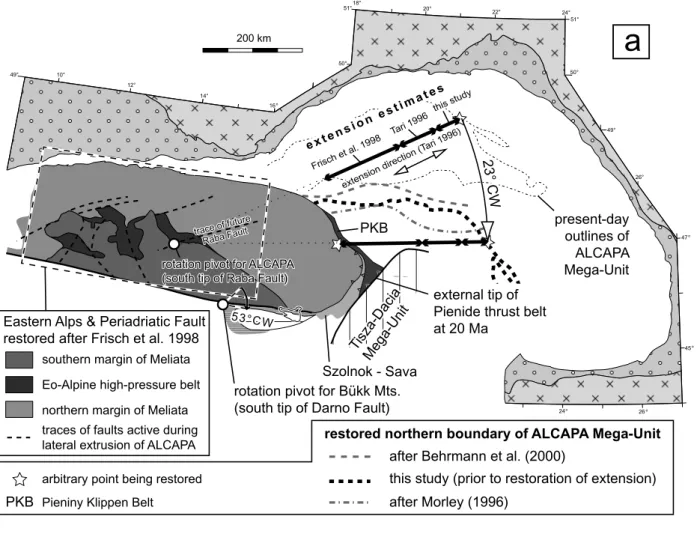
combining the extension values of transects A–A' and b–b' (Fig. 4) yields a net extension of 130 ± 10 km for the northwest-ern part of the Pannonian basin, which is floored by the eastnorthwest-ern parts of the ALcAPA Mega-Unit. combined with 160 km of extension in the Eastern Alps (Frisch et al. 1998), this totals to 290 ± 10 km of overall extension that affected ALcAPA during the Neogene. this value was used to restore the Early Miocene outlines of ALcAPA (Fig. 5a). the raba river exten-sional corridor, bounded to the west by the raba river Fault, is mainly responsible for the Neogene exhumation of the Lower Austroalpine, tatric and Valais units below higher tectonic units (Fig. 2; for more details see Plate 1 in schmid et al. 2008). this extensional corridor is located exactly at the longitude, where the E–W-strike of the Eastern Alps turns into the NE-strike of the West carpathians. the available time constraints (Fig. 3) show that shortening in the Miocene thrust belt of the West carpathians started earlier and lasted longer (Eggenburgian to sarmatian) than core complex formation in the raba river extensional corridor (Karpatian to Early badenian). Kinemati-cally this implies that the eastern part of the ALcAPA Mega-Unit underwent a counter-clockwise rotation prior, during and after its extensional deformation.
δ
1 0l
l
=
δ
1 0l
l
=
In order to restore geometry and location of the eastern parts of ALcAPA prior to rotation, a 23° clockwise rotation around a pivot point located at the sW tip of the raba river Fault was applied to ALcAPA. such a rotation leads to a linear striking rhenodanubian – Magura Flysch belt and results in a position of the northern edge of ALcAPA that is in agree-ment with previous studies (Morley 1996; behrmann et al. 2000; Fig. 5a). Moreover, this rotation also straightens out the Periadriatic Fault and its extension into Hungary (Fodor et al. 1998). We consider the Darno Fault, which separates ALcAPA from the bükk Mountains, to represent part of the Periadri-atic Fault (schmid et al. 2008). We applied an additional 30° clockwise rotation (i.e. 23 + 30 = 53°) to the bükk Mountains in order to align the Darno Fault along-strike with the main trend of the Periadriatic Fault.
In a next step, the eastern margin of ALcAPA was trans-lated westward along a roughly E–W-trending trajectory by c. 280–300 km, corresponding to the extension value arrived at by the above described estimates. the available time con-straints suggest that at 20 Ma the easternmost tip of ALcAPA was just getting in contact with the tisza-Dacia Mega-Unit, as evidenced by burdigalian sE-directed thrusting in the Pienides (tischler et al. 2007; Márton et al. 2007).
2.5 Restoring the Tisza-Dacia Mega-Unit
For those parts of the Pannonian basin, which are floored by the tisza-Dacia Mega-Unit, extension values appear to decrease systematically sE-ward away from the Mid-Hun-garian Fault Zone towards the un-extended transylvanian Fig. 4. Estimates on the extension amount in the Pannonian basin. Fault pattern in the Pannonian basin was adopted from Horváth (1993). the contour map of the crustal stretching factor is taken from Lenkey (1999). All thrusts except the most external one are omitted for reasons of legibility.
ALCAPA Mega-Unit Dinarides, Southern Alps (incl. obducted ophiolites) Tisza and Dacia Mega-Units (incl. obducted ophiolites)
oceanic accretionary prisms Miocene thrust belt
undeformed European foreland and external foredeep
1.0 1.2 1.4 1.6 1.8 2.0
crustal thinning factor
Bucharesti
Cluj Krakow
low angle normal fault high angle normal fault fault unspecified E E' D' D C' C extension directions: Tari, 1996 Fodor et al., 1999 A A’ B B’
dl
tot=147
dl
tot=78
dl
tot=179
dl
tot=147
dl
tot=78
dl
tot=179
dl
tot=50
dl=80±10
Fig. 5. reconstruction of (a) the ALcAPA and (b) tisza-Dacia mega-units according to the constraints described in the text. E E' D' D C' C
extension direction (Fodor et al. 1999) extension direction (Fodor et al. 1999)
present-day outlines of tectonic units C' C this study Tari 1996 Frisch et al. 1998 e xt e n s i on e s t im a t e s e xt e n s i on e s t im a t e s present-day outlines of ALCAPA Mega-Unit Eastern Alps & Periadriatic Fault
restored after Frisch et al. 1998
23° CW 23° CW
rotation pivot for ALCAPA (south tip of Raba Fault) rotation pivot for ALCAPA (south tip of Raba Fault)
rotation pivot for Bükk Mts. (south tip of Darno Fault)
53°CW
extension direction ( Tari 1996)
external tip of Pienide thrust belt at 20 Ma
Tisza-Dacia Mega-Unit Szolnok - Sava
PKB
restored northern boundary of ALCAPA Mega-Unit after Behrmann et al. (2000)
after Morley (1996)
this study (prior to restoration of extension)
arbitrary point being restored traces of faults active during lateral extrusion of ALCAPA
Pieniny Klippen Belt
PKB
trace of future Raba Fault trace of future
Raba Fault
southern margin of Meliata
northern margin of Meliata Eo-Alpine high-pressure belt
a
b
Tisza Mega-Unit
cross sections for estimating magnitude of Neogene extension (Fig. 4) amount of restoration derived from the extension estimates (Fig. 4)
obducted
Eastern Vardar ophiolites Dacia Mega-Unit undeformed European foreland external foredeep
Fig
. 6.
r
estoration of tectonic units in the
Alps
, c
arpathians and Dinarides domain for the Early Miocene
. c
olours and patterns of tectonic units corresponds to those in F
ig
. 2.
trace of future Raba Fault
c. 45 c. 40 c. 70 c. 210 c. 70 25 72 56 56 46 ≥ 50 30 ≥ 50 present-day coast present-day coast
190 km
C
a
r
p
a
t
h
i
a
n
e
m
b
a
y m
e n t
Budapest Bucharesti Wien Krakow Munich Sofia Burgas Ma gu r a 20° 23° 53° 20° 20° 38° 5° 0° 100° 16.5°amount and sense of rotation applied to tectonic units in a forward step
faults active already before 20 Ma
trace of subduction
faults active after 20 Ma
CCW
CW
total convergence between European and
Adriatic plates
at 14°E
displacements implied from regional studies (in km)
46
displacements implied from restoration (in km)
c. 70
rotation pole for
Adria:
45°N, 6°40’E
basin (Krézsek & bally 2006) and the Moesian Foreland (Fig. 4). this is also compatible with the fact that the Neo-gene fault-bounded basins that affect the northwestern part of the Apuseni Mountains shallow out towards southeast (săndulescu et al. 1978); this directly indicates decreasing amounts of extension towards sE. the restored configura-tion of tisza-Dacia was arrived at by shortening the entire mega-unit along transects c–c' to E–E' by the corresponding extension values (Fig. 5b).
For reconstructing the position of the external, leading edge of tisza-Dacia (external with respect to the carpathian thrust facing) during the Early Miocene, we adopted the res-toration of Fügenschuh & schmid (2005). this resres-toration is mainly constrained by retro-deforming 65 km of dextral strike-slip displacement of the tisza-Dacia Mega-Unit relative to the Moesian foreland along the curved timok Fault (see Figure 9c in Fügenschuh & schmid 2005; Moser 2001).
2.6 Restoring the location of the Adriatic Plate
the Early Miocene position of the Adriatic Plate was recon-structed by retro-deforming 1) the Neogene shortening re-corded in the southern Alps, 2) the Neogene dextral strike slip displacements along the Periadriatic and Giudicarie Faults, and 3) the post-20 Ma shortening across the Western Alps.
In the southern Alps west of the Giudicarie Fault the magnitude of Neogene shortening systematically decreases from east to west (schönborn 1992, 1999) and approaches zero along the EcOrs-crOP profile near torino (schmid & Kissling 2000, outside of Fig. 2). the available estimates on the magnitude of Neogene shortening in the southern Alps east of the Giudicarie Fault are minimum estimates only (Nussbaum 2000) and hence it is unclear whether the systematic increase of shortening continues further towards east. We consider the Giudicarie Fault kinematically and temporally related to post-20 Ma shortening within the southern Alps (stipp et al. 2004) and therefore eliminated the later offset of the Peri-adriatic Fault (schmid et al. 1999) by the Giudicarie Fault. the restoration of the southern Alps east of the Giudicarie Fault is hence constrained by assuming an initially straight Periadriatic Fault and satisfying the minimum shortening estimates of Nussbaum (2000). Note, however, that there is no general agreement about an initially straight Periadriatic Fault (see e.g. Viola et al. 2001 for a contrasting opinion). Our palinspastic restoration (Fig. 6) reveals that the Periadriatic Fault aligns with the balaton Fault and its eastern extension along the northern margin of the Mid-Hungarian Fault Zone (Fig. 2), a geometry that allows for the eastward lateral extru-sion of the ALcAPA Mega-Unit.
the magnitude of Neogene dextral strike slip movements along the Periadriatic Fault and its eastern extension var-ies along strike. this is an effect of the E–W extension of the ALcAPA Mega-Unit during its lateral extrusion and displace-ment with respect to the southern Alps, which were not affected by this E–W extension (ratschbacher et al. 1991). Hence, the
Periadriatic-balaton Fault system represents a stretching fault in the sense of Means (1989).
In restoring the Adriatic Plate to its Early Miocene posi-tion, we took into account an extra 30 km of dextral displace-ment that is not related to extrusion of the eastern part of the Alps as a constituent of ALcAPA. this extra displacement is the result of E–W extension across the Lepontine dome in the central Alps, which is largely accommodated along the sim-plon normal fault (just outside the western margin of Fig. 2; Grasemann & Mancktelow 1993).
Post-20 Ma shortening across the Western Alps occurred beyond the area covered by Figs. 2 and 6, but was taken into ac-count since it had an effect on the relative movements between the Adriatic Plate and the ALcAPA Mega-Unit. Neogene shortening across the Western Alps is relatively small, however, and varies from about 35 km near Geneva (e.g. Gratier et al. 1989) to less than 10 km further to the south in the area of the Argentera Massiv (e.g. Lickorish & Ford 1998).
the three categories of interrelated constraints on the Neogene motion of the Adriatic Plate mentioned above jointly indicate that it underwent a combination of translation and si-multaneous rotation. Once the north-directed displacement of the Adriatic Plate related to shortening in the southern Alps has been restored to the pre-20 Ma situation, a 20° counter-clockwise rotation had to be applied to the Adriatic Plate that is described by a pivot pole located in the vicinity of torino (at 45° N and 6°40’E, Figs. 6 and 7). We emphasise that this rota-tion is a product of the above-menrota-tioned constraints obtained from outside the Adriatic Plate. Independent estimates how-Fig. 7. comparison of the rotation pole of the Adriatic plate indenter derived in this study (black) with previously derived poles (from the inversion of seis-motectonic and/or geodetic data). the assumption of a largely rigid, rotating Adriatic plate indenter implies an increase of displacement away from the rotation pole (shown by arrows that are concentric around the rotation pole). the coastline of the Italian part of the Adriatic sea (lying on the stable Adri-atic plate) would thus be restored back to a position shown by the dashed line.
this study
Weber et al. 2006 Calais et al. 2002 Battaglia et al. 2004Anderson & Jackson 1987
position of Adriatic Sea coastline
restored to 20 Ma position of Adriatic Sea coastline
restored to 20 Ma 20°E 20°E 18°E 18°E 16°E 16°E 14°E 14°E 12°E 12°E 10°E 10°E 8°E 8°E 6°E 6°E 48°N 48°N 46°N 46°N 44°N 44°N 42°N 42°N 40°N 40°N 0 200 km
ever, based either on paleomagnetic data (see below), the in-version of seismotectonic (Anderson & Jackson 1987) or GPs data (calais et al. 2001; battaglia et al. 2004; Weber et al. 2006) also consistently indicate a counter-clockwise rotation of the Adriatic Plate (Fig. 7).
2.7 Restoring the tectonic units of the Dinarides
the restoration of the major units of the Dinarides is not based on quantitative estimates of post-20 Ma shortening but is in-directly constrained by the retro-deformations applied to the Adriatic Plate and the tisza-Dacia Mega-Unit. Within the Dinaridic-southern Alpine domain we allowed for displace-ments along the following faults that were active during the past 20 Ma: (1) south-directed thrusting in the eastward con-tinuation of the Miocene Alpine retro-wedge (southern Alps and their continuation into slovenia and Hungary; schmid et al. 2008 and references therein), (2) ongoing shortening along the frontal thrust of the Dinarides offshore Dalmatia (e.g. ben-nett et al. 2008) and in line with evidence for thrusts affecting Pliocene to Quaternary sediments in the Albanian foredeep, offshore Montenegro and Albania (Picha 2002), (3) transpres-sion along the split-Karlovac Fault (chorowicz 1970, 1975 and Geological Map of former Yugoslavia) and (4) thrusting along the frontal thrust of the High-Karst Unit and budva-cukali Zone, respectively, which override the Dalmatian Zone and its southward continuation, the Kruja Zone of Albania (Aubouin & Ndojaj 1964) and the Gavrovo-tripolitza Zone of Greece (Jacobshagen 1986). this thrusting affects also Mid-Miocene sediments according to new data (de capoa et al. 1995; Mikes et al. 2008). the partitioning of displacements across the faults chosen in Fig. 6 is not constrained by hard data and will be dis-cussed below.
the internal edge of the tisza-Dacia Mega-Unit (internal with respect to the external one facing the carpathian thrusts) is located adjacent to the sava Zone, which is considered as forming the suture zone between Dinarides and tisza-Dacia Mega-Unit (schmid et al. 2008; Ustaszewski et al. submit-ted). Final closure of the Neotethyan oceanic basins along the sava Zone had occurred in Maastrichtian to Early Paleogene times (Pamić 1993, 2002). this is constrained by the observa-tion that Early Miocene syn-rift sediments of the Pannonian basin system seal Mid-Eocene siliciclastics, which are affected by the last stages of post-collisional thrusting (tari 2002; Usta-szewski et al. submitted). consequently, the internal Dina-rides are assumed to have remained attached to the tisza-Dacia Mega-Unit during the last 20 Ma. Hence the position of the internal Dinarides 20 Ma is essentially controlled by the restoration of the tisza-Dacia Mega-Unit. Nevertheless, some minor geometrical adjustments were required across the sava Zone (Fig. 6). these adjustments, which are relatively minor and uncontrolled by data, are thought to relate to extensional and subsequent Pliocene to recent inversion tectonics along the southern margin of the Pannonian basin in croatia and serbia (tomljenović & csontos 2001; saftić et al. 2003).
Dex-tral strike slip movements along the sava Zone in southern serbia and Macedonia are a consequence of the restoration (see below).
3. Discussion
3.1 Implications for the Southern Alps – Dinarides realm the Early Miocene restoration presented in Fig. 6 implies that the Neogene rotational northward motion of the Adri-atic plate with respect to the stable foreland of the European plate resulted in some 190 km total N–s shortening in the tri-este – Eastern Alps area, at a longitude of 13° E to 15° E. this shortening is partitioned between south-directed thrusting in the southern Alps, shortening within the ALcAPA Mega-Unit and very minor N-directed thrusting onto the northern Alpine foreland. Due to the counter-clockwise rotation of the Adriatic plate shortening in the southern Alps decreases westward to-wards the rotation pivot point (Fig. 6). this decrease in short-ening is compatible with estimates of Miocene N–s shortshort-ening across the Alps of Eastern switzerland amounting to 61 km during the last 19 Ma (schmid et al. 1996).
conversely, the counter-clockwise rotation of the Adriatic plate indenter implies that with increasing distance E-ward away from the rotation pivot point the magnitude of shorten-ing progressively increases (Fig. 7). In keepshorten-ing with this rela-tionship, small changes in the assumed rotation angle lead to drastic variations in the magnitude of shortening in the sE-most parts of the Dinarides, for which the deduced total shortening of 235 km is subject to large uncertainties. We interpret this short-ening (25 + 210 km in Fig. 6) to have been predominantly taken up in the external Dinarides (offshore Dalmatia, along the split-Karlovac Fault, along the frontal thrust of the High-Karst Unit and, further south, in front of and within the budva-cukali-Pin-dos Zone). It is very difficult to assess how this total post-20 Ma shortening in the external Dinarides is partitioned between the thrusts at the front and at the rear of the Dalmatian Zone (and its southward continuation, the Gavrovo-tripolitza Zone). In Fig. 6 we gave preference to large amounts of shortening at the rear of the Dalmatian Zone since the amount of shortening in front of the Kruja Zone, i.e. offshore Albania appears to be relatively small (Picha 2002) while by far more substantial shortening oc-curred across the more internal budva-cukali or Krasta-Pindos Zone during the Neogene (Kilias et al. 2001). Note that Neo-gene to recent shortening in the Hellenides, however, occurred in a more external domain, in front of the Gavrovo-tripolitza Zone (van Hinsbergen et al. 2005).
the deduced differential northward displacement of the Adriatic plate implies that the thrusts of the Dinarides also accommodated dextral strike-slip displacements. substantial strike-slip faulting apparently overprinted the thrust faults of the internal Dinarides and the sava-Vardar suture of the sava Zone (see also Morley 1996). Dextral transpression is directly evidenced by the presently observed steep dip of these thrusts (see profile 5 of Plate 2 in schmid et al. 2008).
3.2 Extension in the Pannonian Basin and contemporaneous thrusting in the external Carpathians
Our estimate of some 290 km sW–NE extension in the ALcAPA Mega-Unit roughly corresponds to the minimum estimate of some 260 km shortening that was accommodated in the NE carpathian thrust belt (behrmann et al. 2000). this illustrates that Miocene thrusting and extension in these two domains are not only coeval, as proposed by royden et al. (1983), but also of similar magnitude as shown by behrmann et al. (2000). this supports the concept of a retreating carpathian subduction zone, causing coeval back-arc extension. thereby the rate of subduction is mostly or exclusively taken up by ex-tension while the plate convergence rate, as defined by royden & burchfiel (1989), approaches zero.
comparing Figures 2 and 6 reveals that the invasion of the ALcAPA and tisza-Dacia mega-units into the carpathian em-bayment and ultimately their docking to the European fore-land across the Miocene thrust belt was largely accommodated by their contemporaneous extension. Most of the significant and complex motions between these two extending mega-units took place across the Mid-Hungarian Fault Zone (csontos & Nagymarosy 1998). these motions were variably of a transpres-sional, strike slip and/or transtensional nature and were accom-panied by block rotations that will be discussed in the light of paleomagnetic data below (see tischler 2005; tischler et al. 2007; Márton et al. 2007 for an analysis of the NE tip of the Mid-Hungarian Fault Zone).
Our restoration brings the Magura flysch belt and the sava Zone, both forming part of the cenozoic Alpine-Di-naridic suture zone, closely together. It also leads to a good alignment of the internal Dinarides and their two fragments, which are preserved in the bükk and Medvednica Mountains (tomljenović et al. 2000; tomljenović 2000, 2002; Dimitrijević et al. 2003; schmid et al. 2008; tomljenović et al. 2008). the opposed subduction polarity between Alps-Western carpath-ians and Dinarides demands, however, substantial post-col-lisional geometrical modifications of this suture (Laubscher 1971). Our model, which in many respects is similar to that of royden & baldi (1988), proposes that the precursor of the present-day Mid-Hungarian Fault Zone acted as a transform fault between the opposed Alpine and Dinaridic subduction zones in Paleogene times. since the wide area of the carpath-ian embayment, depicted in Fig. 6, must have largely disap-peared as a result of subduction zone retreat of the European Plate rather than by plate convergence, we speculate that this area was at least partly underlain by old, i.e. dense oceanic lithosphere rather than thick and buoyant continental litho-sphere.
3.3 Inferences from block rotations and comparison with paleomagnetic data
Our restoration predicts counter-clockwise and clockwise ro-tations of the ALcAPA and tisza-Dacia mega-units,
respec-tively, during their advance into the carpathian embayment. this is in qualitative, albeit not quantitative, agreement with the results of paleomagnetic studies on these two mega-units (e.g. Patrascu et al. 1994; Márton & Fodor 1995, 2003; Márton & Márton 1996; Panaiotu 1998, 1999; Márton 2000). In gen-eral our restoration predicts smaller rotations than those in-ferred from paleomagnetic data. this can partly be explained by the fact that the two extending mega-units do not repre-sent rigid blocks, and that smaller blocks forming perhaps part of larger scale fault zones may be subjected to more in-tense rotations. On the other hand, the timing of magnetiza-tion, and hence the timing of these rotations cannot always be determined accurately. In the case of the tisza-Dacia Mega-Unit Fügenschuh & schmid (2005) argued, based on purely geological-tectonic arguments, that much of a total of 90° clockwise rotation, generally reported to be entirely of Miocene age (e.g. Patrascu et al. 1994), pre-dates the Mio-cene.
In the case of the counter-clockwise rotation of the ALcAPA Mega-Unit we interpret this rotation to result from the combined effect of slab retreat and its collision with the simultaneously advancing tisza-Dacia Mega-Unit (e.g. tischler et al. 2007). However, we regard the clockwise rotation of the tisza-Dacia Mega-Unit to be driven by slab retreat only; it was accommodated by dextral displacements along the timok and cerna-Jiu Faults (Fügenschuh & schmid 2005).
concerning the counter-clockwise rotation of the Adriatic Plate and the external Dinarides we again obtain a smaller amount of rotation (20°) from our reconstruction compared to the 30° inferred from paleomagnetic data for latest Miocene to recent times (Márton et al. 2003). It is evident that rotations larger than those predicted by our restoration would not only be inconsistent with the data we used as input for our restora-tion but also would lead to massive overestimates of shortening in the southern Dinarides, located far from the pole of rota-tion.
the clockwise rotations of up to 100° recorded on frag-ments of the internal Dinarides exposed in the Medvednica Mountains are interpreted as being restricted to small blocks (tomljenović 2002; tomljenović et al. 2008) rather than applying to the Dinarides as a whole. the 53° counter-clockwise rotation, which we applied in our reconstruction to another fragment of the internal Dinarides, the bükk Mountains, was arrived at by leaving this fragment attached to the ALcAPA Mega-Unit and by straightening out the Periadriatic-balaton-Darno Faults. this qualitatively agrees also well with paleomagnetic data from the bükk Mountains reporting counter-clockwise rotations between 30 and 80° (Márton & Fodor 1995), as well as tectonic and paleogeo-graphic data (csontos 1999, 2000). the 16.5° clockwise rota-tion indicated in Fig. 6 for the southernmost part of the tisza-Dacia Mega-Unit is, on the other hand, a mere consequence of our restoration and is not supported by paleomagnetic data.
3.4 Implications regarding the present-day lithosphere-scale configuration
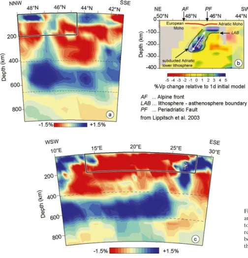
Our reconstruction has bearings on the interpretation of the present-day lithospheric configuration of the Alpine-car-pathian-Dinaridic orogenic system (Figs. 8 & 9). In particular, it potentially provides an explanation for the change in the
lithosphere-scale configuration that is observed in the Eastern Alps according to recent results of high-resolution teleseismic mantle tomography (Lippitsch et al. 2003; schmid et al. 2004a,b; Kissling et al. 2006). this work demonstrated the existence of a NNE-dipping lithospheric slab (“Adriatic slab”) underneath the Eastern Alps in the area east of the Giudicarie Fault (Fig. 9b; Lippitsch et al. 2003), while another slab (“European slab”) Fig. 8. Horizontal tomographic sections through the study area ranging from 50 km (a) to 250 km depth (e). the black polygon shows the range of Fig. 2; dashed lines show the traces of the vertical sections (Fig. 9). the sections are derived from the seismic tomography model of bijwaard & spakman (2000). see text for further details.
preserved west of this fault dips to the sE (Kissling et al. 2006), as is expected for the European lithosphere which represents the southwards subducted lower plate during Alpine collision. the consistent overall architecture of the crustal configuration during Alpine collision, unchanged all the way into the Western carpathians (schmid et al. 2008), implies that the European lithosphere formerly represented the lower plate also in the area east of the Giudicarie Fault; this in turn suggests that a late-stage post-collisional modification of the lithosphere-scale geometry must have occurred in the easternmost Alps. In a first step we discuss the time constraints for the onset of this change in subduction polarity, and in a second step we suggest possible mechanisms, which could have led to this severe modification.
the length of the subducted “Adriatic slab” east of the Giu-dicarie Fault was estimated to about 210 km along a NE–sW section (Fig. 9b; Lippitsch et al. 2003) across the Eastern Alps. Within error this value is perfectly compatible with our esti-mate of a total of 190 km N–s-shortening (Fig. 6) inferred for a N–s transect through the trieste – Eastern Alps area, which intersects the tomography section c–c' of Lippitsch et al. (2003; see Fig. 9b). this strongly suggests that the NE-directed subduction of the Adriatic lithosphere was associated with post-20 Ma crustal shortening. the average plate convergence rate would be in the order of 1 cm yr–1 for the last 20 Ma across
the Eastern and southern Alps along the transect depicted in Fig. 9b. According to our palinspastic restoration (Fig. 6) the post-20 Ma plate convergence rate decreases westwards, which agrees with the plate convergence rate estimates between 0.3 and 0.5 cm yr–1 derived from an Alpine transect through
East-ern switzerland and based on geological estimates (schmid et al. 1996). Note that present-day convergence rates between the western parts of the Adriatic plate are also smaller, i.e. in the order of 0.5 cm yr–1 (battaglia et al. 2004).
based on literature data and the results of our restoration we propose that a dramatic change has occurred at about 20 Ma, when the s to sE-wards subducting European Plate gave way to the NE-wards subducting Adriatic Plate below the Alps east of the Giudicarie Fault. comparison of Figs. 2 and 6 reveals that the change in subduction polarity in the easternmost Alps was associated with substantial strike slip displacements and hence cannot be understood without considering the entire Alpine-carpathian-Dinaridic system in three dimensions.
In order to analyse the geometry of the mantle lithospheric configuration east of the Giudicarie Fault in more detail, we present five horizontal tomographic slices (Fig. 8) that were de-rived from the seismic tomography model of bijwaard & spak-man (2000). Inconsistencies between these sections and those presented in the area of the Eastern Alps are primarily due
Fig. 9. Vertical tomographic sections through the study area. (a) and (c) are sections derived from the seismic tomography model of bijwaard & spakman (2000), (b) represents section c–c' of Lippitsch et al. (2003). the bold black rectangles in (a) and (c) show the extent of the vertical walls of the block diagram of Fig. 11.
to the higher resolution achieved by Lippitsch et al. (2003) in the Alpine region, who applied corrections for lateral velocity changes in the crust. the sections show the following first-or-der characteristics that can also be seen in the horizontal sec-tions of Piromallo & Morelli (2003, their Fig. 8): (1) High Vp
anomalies in the sections at 50 and 100 km depth (Figs. 8a & b) suggest a continuous Adriatic lithosphere between the Eastern Alps and the Dinarides. At depths greater than 100 km, high Vp
anomalies underneath the Dinarides are confined to latitudes south of 44° N, but are absent further north (Fig. 8c-e). this sug-gests that an Adriatic lithosphere slab dipping underneath the Dinarides is only present south of 44° N and that a connection to the slab underneath the Eastern Alps identified by Lippitsch et al. (2003) cannot be inferred from the data available. (2) the area of high Vp below the northernmost Eastern Alps (north
of latitude 47° in Fig. 8a) is part of the European lithosphere, which also surrounds the Eastern carpathians based on geo-logical arguments. Note that the immediate connection of high velocity mantle underneath the Eastern Alps to the circum-carpathian European lithosphere is not obvious from Fig. 8. Further east, however, the European lithosphere is again well depicted by fast velocities in Figs. 8 b to e, and connects south-eastwards with the sub-vertically oriented Vrancea slab north of bucharest that is a part of Moesia (Matenco et al. 2007). (3) Low velocities characterise the area of the Pannonian basin. the area of high velocities underneath the Eastern Alps de-picted in the horizontal sections of Fig. 8 cannot unequivocally be attributed to either the Adriatic slab identified by Lippitsch et al. (2003) nor, alternatively, to a remnant of the former s-ward subducting European slab that must have retreated or broken off at 20 Ma, giving way to the Adriatic slab.
In order to further investigate this matter we looked at three vertical tomographic sections (Fig. 9). Fig. 9a clearly shows a horizontal high velocity body located at the northernmost rim of the Alps north of about 47° latitude and extending into the bohemian massif (see also Fig. 8a). the lower interface of this body extends down to a depth of less than 100 km. because of its location, this high velocity body clearly has to be correlated with the European lithosphere. the downward tapering low velocity anomaly at 47° N coincides with the topographically highest part of the Eastern Alps along this transect and very likely represents a deep crustal root underneath the Eastern Alps (see Kissling & spakman 1996). the high velocities south of 47° N represent Adriatic lithosphere that dips steeply north-ward underneath the European lithosphere. the exact length of this slab cannot be estimated from Fig. 9a due to “blurring” (upward conical high velocity anomalies that are likely caused by the incident angles of the ray paths used in the tomogra-phy).
the section in Fig. 9b represents the high-resolution to-mographic section of Lippitsch et al. (2003) and is shown at exactly the same scale as the section in Fig. 9a. the Adriatic slab is clearly shown to be dipping underneath the Eastern Alps reaching a depth of c. 270 km. In combination, the sec-tions Fig. 9a and 9b clearly suggest that Adriatic lithosphere is
dipping underneath the European lithosphere. the section in Fig. 9c shows that the high velocity body representing the Adri-atic lithosphere at the western end of the section does not con-tinue further to the east beyond 15° E (longitude of Zagreb), neither horizontally nor as a dipping slab. the Pannonian basin is characterised by low velocities throughout, suggesting a very reduced lithosphere thickness there. However, assuming that an average stretching factor δ around 1.6 (see section 2.3) also affected the mantle lithosphere, initial total lithosphere ness being c. 100 km, one would still expect a lithosphere thick-ness of roughly 60 km from tectonic stretching alone, i.e. much more than observed in Fig. 9c. this discrepancy confirms the widely accepted view first proposed by sclater et al. (1980) that the lithosphere underneath the Pannonian basin has been, in addition to tectonic stretching, substantially thermally attenu-ated. this is also in line with the widespread occurrence of Late Miocene to Pleistocene alkalic and mafic magmatics with an inferred asthenospheric source, postdating subduction-related magmatism in the area (e.g. Wilson & Downes 2006).
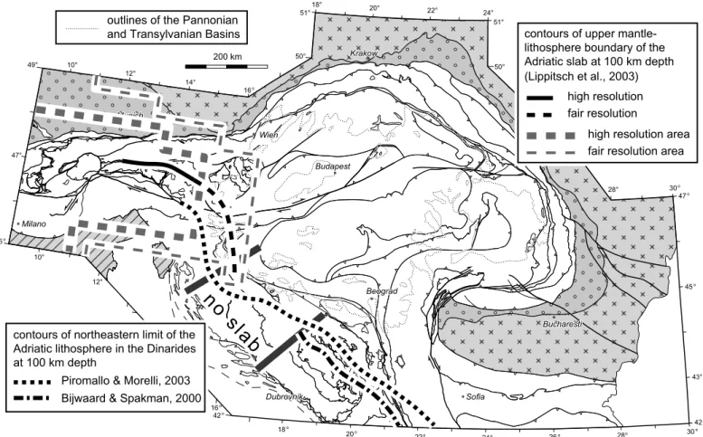
the horizontal depth slices at 100 km depth by Lippitsch et al. (2003, their Fig. 12a), Piromallo & Morelli (2003, their Fig. 8) and our Fig. 8b were used for mapping the location of the upper mantle-lithosphere boundary of the NE-ward subducted Adri-atic slab underneath the Eastern Alps and internal Dinarides, or the eastern limit of the Adriatic lithosphere where no slab can be discerned dipping underneath the Dinarides. We did this by contouring the transition from positive to negative Vp
variations along the presumed NE edge of the Adriatic litho-sphere as it intersects these three horizontal sections. We are fully aware that the 0% Vp variation contours in the horizontal
sections are not comparable, since they strongly depend on the Vp mantle velocity models used by the different authors as well
as on the accuracy of these models. Nevertheless we plotted these contours onto the tectonic map of Fig. 2 for a qualita-tive assessment (Fig. 10). In combination with Figs. 8 and 9, the contours in Fig. 10 suggest the following: (1) the Adriatic litho-sphere can be traced continuously from the Eastern Alps into the Dinarides. (2) However, a lithospheric slab can only be con-fidently identified in the high-resolution area of Lippitsch et al. (2003) and south of 44° N (roughly the latitude of sarajevo) in the Dinarides, but is absent according to the tomographic data available in the area between. Given the currently available to-mographic models, the southeastern limit of the Adriatic slab identified by Lippitsch et al. (2003) is speculative. Horváth et al. (2006) suggested its south-eastern termination along the Zagreb Line (corresponding to the western part of the Mid-Hungarian Fault Zone, Fig. 2). this problem should be addressed by future geophysical studies. Interestingly, the area where no Adriatic slab can be seen in the tomographic models coincides with the location of the western rim of the Pannonian basin in parts of the Dinarides, a basin that has experienced substantial tectonic stretching and asthenospheric uprising. It is therefore conceiv-able that asthenospheric upwelling underneath the Pannonian basin led to a severe modification of a formerly continuous Adriatic lithospheric slab dipping underneath the Dinarides,
just as it caused strong thermal attenuation of the lithosphere underneath the Pannonian basin itself, creating pathways for asthenosphere-derived melts.
Fig. 11 presents a 3D sketch, which integrates the present-day crustal structure of the Alpine-carpathian-Dinaridic sys-tem (schmid et al. 2008) with the present-day lithosphere-scale configuration inferred from the results of mantle tomography discussed above. this sketch allows for a brief discussion of the mechanisms, which could have led to changes of the original lithospheric configuration that induced the severe post-20 Ma crustal displacements, rotations and deformations that are evi-dent from comparing Figures 2 and 6.
clearly, the post-20 Ma emplacement of a once continuous Adriatic slab underneath the Eastern Alps was only possible once the European slab underneath the Eastern Alps gave way by slab break-off, a process that initiated earlier, i.e. between 40 and 35 Ma, in the transition area between Western and East-ern Alps (von blanckenburg & Davis 1995) but took place at around 20 Ma in the Eastern Alps and the area of the carpath-ian embayment. Whether or not this break-off was a continuous process, systematically migrating eastward (spakman & Wortel
2000), is not yet fully understood. the carpathian embayment was formerly underlain, according to most authors (e.g. balla 1982; Mason et al. 1998), at least partly by oceanic lithosphere. subduction and slab retreat (e.g. royden 1988; Wortel & spak-man 2000; sperner et al. 2002, 2005), starting at around 20 Ma in the area of the carpathian embayment, created the necessary space that allowed for the invasion of the ALcAPA, tisza and Dacia mega-units and the formation of the highly arcuate Al-pine-carpathian orogenic system. However this retreat, associ-ated with severe crustal thinning and upwelling of the asthe-nosphere underneath the Pannonian basin, cannot be the only driving force for this substantial post-20 Ma reorganization.
rotation and north-directed translation of the Adriatic Plate indenter, also including the underpinnings of the adja-cent Dinaridic orogen, provided a second and probably equally important driving force for these modifications. the displace-ment of the Adriatic Plate, of course in combination with slab break off or retreat of the European Plate, led to the change in subduction polarity along the transect through the eastern-most Alps depicted in Fig. 11. Due to the simultaneous counter-clockwise rotation of the Adriatic Plate indenter, its effects in Fig. 10. contours of the upper mantle-lithosphere boundary of the Adriatic slab at 100 km depth as inferred from the 3D Vp-model of Lippitsch et al. (2003, their Fig. 12) in comparison with the contours of the eastern limit of the Adriatic lithosphere underneath the Dinarides using the horizontal depth slices at 100 km depth of Piromallo & Morelli (2003, their Fig. 8) and bijwaard & spakman (2000; our Fig. 8b). the contours were derived by tracing the transition from posi-tive to negaposi-tive Vp variations of each model along the presumed NE edge of the Adriatic lithosphere. the contours are superimposed onto the outlines of the tectonic units of Fig. 2. see text for further details.
43° 47° Budapest Bucharesti Beograd Wien Krakow Dubrovnik Munich Milano Sofia
contours of upper mantle-lithosphere boundary of the Adriatic slab at 100 km depth (Lippitsch et al., 2003)
high resolution fair resolution
high resolution area fair resolution area
Bijwaard & Spakman, 2000 Piromallo & Morelli, 2003 contours of northeastern limit of the Adriatic lithosphere in the Dinarides at 100 km depth
no
s
la
b
no
s
la
b
outlines of the Pannonian and Transylvanian Basins
Fig . 11. Interpretative block diagram showing present-day lithospheric structures in the Eastern Alps , c arpathians and northern Dinarides . t he horizontal lid of the block represents a simplified version of the tectonic map presented in Fig . 2; the vertical block walls are interpretative representations of the vertical tomographic sections (F ig . 9a and c). t he MOHO depth in the N– s-trending , western edge of the block is roughly after b rückl et al. (2007). In the E–W -trending edge of the block, no seismic MOHO is shown, but the fossil crust-mantle boundary in order to better document the lithosphere tectonics . In addition to tectonic stretching , the lithosphere underneath the Pannonian b asin is also strongly thermally attenuated, giving a possible explanation for the absence of the
Adriatic lithospheric slab underneath the Dinarides
.