HAL Id: hal-01805147
https://hal.archives-ouvertes.fr/hal-01805147
Submitted on 9 Oct 2020
HAL is a multi-disciplinary open access
archive for the deposit and dissemination of
sci-entific research documents, whether they are
pub-lished or not. The documents may come from
teaching and research institutions in France or
abroad, or from public or private research centers.
L’archive ouverte pluridisciplinaire HAL, est
destinée au dépôt et à la diffusion de documents
scientifiques de niveau recherche, publiés ou non,
émanant des établissements d’enseignement et de
recherche français ou étrangers, des laboratoires
publics ou privés.
A key continental archive for the last 2 Ma of climatic
history of the central Mediterranean region: A pilot
drilling in the Fucino Basin, central Italy
B. Giaccio, E. Regattieri, G. Zanchetta, Bernd Wagner, P. Galli, G. Mannella,
E. Niespolo, E. Peronace, P. Renne, S. Nomade, et al.
To cite this version:
B. Giaccio, E. Regattieri, G. Zanchetta, Bernd Wagner, P. Galli, et al.. A key continental archive for
the last 2 Ma of climatic history of the central Mediterranean region: A pilot drilling in the Fucino
Basin, central Italy. Scientific Drilling, Copernicus Publications, 2015, 20, pp.13 - 19.
�10.5194/sd-20-13-2015�. �hal-01805147�
Sci. Dril., 20, 13–19, 2015 www.sci-dril.net/20/13/2015/ doi:10.5194/sd-20-13-2015
© Author(s) 2015. CC Attribution 3.0 License.
Science
Repor
ts
A key continental archive for the last 2 Ma of climatic
history of the central Mediterranean region: A pilot
drilling in the Fucino Basin, central Italy
B. Giaccio1, E. Regattieri1, G. Zanchetta2, B. Wagner3, P. Galli1,4, G. Mannella2, E. Niespolo5, E. Peronace1, P. R. Renne5,6, S. Nomade7, G. P. Cavinato1, P. Messina1, A. Sposato1, C. Boschi8,
F. Florindo9, F. Marra9, and L. Sadori10
1Istituto di Geologia Ambientale e Geoingegneria, CNR, Rome, Italy 2Dipartimento di Scienze della Terra, UniPI, Pisa, Italy
3Institute of Geology and Mineralogy, University of Cologne, Cologne, Germany 4Dipartimento di Protezione Civile Nazionale, Rome, Italy
5Department of Earth and Planetary Science, University of California, Berkeley, USA 6Berkeley Geochronology Center, Berkeley, USA
7Laboratoire des Sciences du Climat et de l’Environnement (CEA-CNRS-UVSQ), Gif-Sur-Yvette, France 8Istituto di Geoscienze e Georisorse, CNR, Pisa, Italy
9Istituto Nazionale di Geofisica Vulcanologia, Rome, Italy
10Dipartimento di Biologia Ambientale, University of Rome “La Sapienza”, Rome, Italy
Correspondence to: B. Giaccio (biagio.giaccio@cnr.it)
Received: 9 September 2015 – Revised: 10 November 2015 – Accepted: 15 November 2015 – Published: 17 December 2015 Abstract. An 82 m long sedimentary succession was retrieved from the Fucino Basin, the largest intermountain tectonic depression of the central Apennines. The basin hosts a succession of fine-grained lacustrine sediments (ca. 900 m-thick) possibly continuously spanning the last 2 Ma. A preliminary tephrostratigraphy study allows us to ascribe the drilled 82 m long record to the last 180 ka. Multi-proxy geochemical analyses (XRF scanning, total organic/inorganic carbon, nitrogen and sulfur, oxygen isotopes) reveal noticeable variations, which are in-terpreted as paleohydrological and paleoenvironmental expressions related to classical glacial–interglacial cycles from the marine isotope stage (MIS) 6 to present day. In light of the preliminary results, the Fucino sedimentary succession is likely to provide a long, continuous, sensitive, and independently dated paleoclimatic archive of the central Mediterranean area.
1 Introduction
Understanding the spatio-temporal variability, the magni-tude, and the different expressions of Quaternary orbital and millennial-scale paleoclimatic changes across regions is a frontier challenge of modern paleoclimatology (e.g. EPICA community members, 2006). Addressing this issue requires the acquisition of regionally representative high-resolution and well-dated records of climatic variability.
In this framework, the Fucino paleolake in central Italy (Fig. 1a) should add a nodal point in the western, currently vacant area of a network of long terrestrial Mediterranean
records (including e.g. the Dead Sea (Neugebauer et al., 2014), Lake Van (Litt and Anselmetti, 2014), Lake Ohrid (Wagner et al., 2009), and the Tenaghi Philippon (Pross et al., 2015)). Indeed, among the central Italy intermountain tec-tonic depressions, it is probably one of the oldest and the only one that hosts a continuous, lacustrine succession since the late Plio–Quaternary (Fig. 1b). The site is also ideal because of its proximity to Quaternary peri-Tyrrhenian volcanic cen-tres (Fig. 2) that on occasion deposited tephras in the basin that serve today as important chronological marker beds (e.g. Giaccio et al., 2012, 2015; Regattieri et al., 2015). This is a crucial requirement for comparing intra- and inter-regional
14 B. Giaccio et al.: A pilot drilling in the Fucino Basin, central Italy
Figure 1.Reference map of the Fucino Plain with a representative seismic line. (a) Shaded relief of the Fucino Plain showing the location
of the GeoLazio (GL), Telespazio (TS), Strada Provinciale 20 (SP) and Fucino 1 and 3 (F1–3; this study) boreholes. Dashed blue lines are the isochrones (in ms) of the Plio–Quaternary basin infilling with respect to the Quaternary master faults (red bold lines) responsible for the asymmetrical (half-graben) basin geometry. Dotted green lines are the traces of the available seismic lines. (b) Seismic line 3 (see trace in panel a) showing the internal architecture of the Plio–Quaternary continental deposits of the Fucino Basin along a W–E-oriented profile. The projected location of the GL, SP, and F1–3 boreholes is also shown. A, B, C: main unconformities; Seq. 2: Messinian foredeep sediments; Seq. 3: Pliocene fluvial and alluvial deposits; Seq. 4: Quaternary lacustrine and fluvial deposits. The figure and the information were compiled with some modifications from Cavinato et al. (2002), Galli et al. (2012), and Patacca et al. (2008).
paleoclimatic records, based on different dating methods, for evaluating the temporal relationship between them and with respect to the main climatic forcing (e.g. orbital).
With this purpose, an 82 m long core was recovered from the central eastern Fucino Basin (F1–3 in Fig. 1) in June 2015. The major goals of this drilling were to (i) collect a continuous record back to MIS (marine isotope stage) 6, (ii) assess the quality of the lacustrine sedimentary suc-cession, (ii) explore the sensitivity of different paleocli-matic proxies, and (iii) document the presence of widespread tephras useful for regional to extra-regional correlation and their suitability for40Ar/39Ar dating.
2 Geological setting and general background
The Fucino Basin (Fig. 1) is one of the largest intermoun-tain depressions formed during the Plio–Quaternary exten-sional phase along the Apennine Chain (e.g. D’Agostino et al., 2001) within the earlier fold-and-thrust-belt system (e.g.
Patacca and Scandone, 2007). Its opening was mainly driven by a major 110–130◦N trending fault system (Galadini and Galli, 2000; Fig. 1a), which led to the formation of a typi-cal half graben with up to ∼ 900 m of thick Quaternary de-posits in the hanging wall of the master faults (Cavinato et al., 2002; Fig. 1b). Prior to the drainage, undertaken first by Ro-mans in 1st century AD and then at the end of the 19th cen-tury (e.g. Galadini and Galli, 2001), the Fucino Basin hosted the largest lake (∼ 150 km2, 20 m maximum water depth) of peninsular Italy.
In the past decades, several cores were drilled in the Fu-cino Basin for scientific and geotechnical purposes (Fig. 1). A preliminary palynological study of the 200 m long Geo-Lazio core (GL in Fig. 1) led to the conclusion that the upper 65 m of the succession would span the last 130 ka (Follieri et al., 1986). However, the dating of a thick tephra layer at ∼101 m depth yielded an age of 540 ± 9 ka (Follieri et al., 1991), hardly compatible with this chronological framework. Later, Narcisi (1994) analysed two foiditic tephra occurring
B. Giaccio et al.: A pilot drilling in the Fucino Basin, central Italy 15
Figure 2.Location of the Fucino Basin with respect to the main
volcanic districts of central and southern Italy (age in brackets rep-resent the interval of volcanic activity). It is in a good range of distance with respect to the Quaternary tephra sources and in a favourable position with respect to the prevailing eastward direc-tion of the stratospheric winds and hence for tephra dispersion. The locations of Sulmona and Campo Felice are also shown.
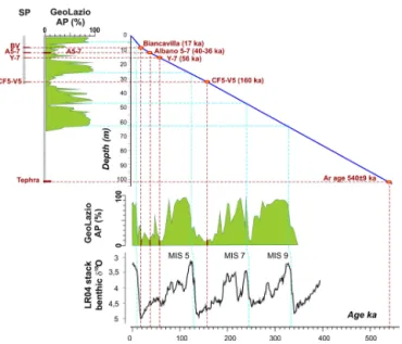
in the GeoLazio and Telespazio cores (TS in Fig. 1), at ∼ 12– 14 m depth, which, on the basis of their peculiar glass major element composition, were attributed to the eruptive units Al-bano 5–7 (Giaccio et al., 2007), from a cluster of Colli Albani eruptions dated between 40 and 36 ka (Giaccio et al., 2009). Finally, the tephrostratigraphic study of a 30 m deep bore-hole (SP in Fig. 1a) drilled close to the GeoLazio site, and in a comparable range of the isochrones of the Quaternary infill (Fig. 1a), allowed for the recognition of some relevant tephra markers spanning between ca. 18 and ca. 160 ka (Au-thors’ unpublished data; Fig. 3). All of these chronological constraints lead us to a reinterpretation of the chronology of the GeoLazio pollen record, spanning the MIS 1–9 interval, suggesting that the Fucino succession extends continuously at least back to ∼ 540 ka (Fig. 3).
3 Material and methods
3.1 Drilling site selection and procedure
The drilling site was selected using an evaluation of sedimen-tation rate obtained from the new interpresedimen-tation of the Geo-Lazio pollen profile (Fig. 3) and the general sedimentary– tectonic architecture of the basin (Fig. 1). With the aim to re-cover a record spanning back into MIS 6, we selected an area located some kilometres eastward from the GeoLazio and SP core sites, i.e. toward the depocentre where the isochrones are deeper (Fig. 1). Therefore, this site provided us the op-portunity of recovering a succession more expanded than the GeoLazio core.
At the selected site (42.00◦N, 13.56◦E), two parallel cores were recovered. The first hole (F1) was drilled down to a field depth of 75 m and the second hole (F3) down to 56.25 m. The length of the single recovered core section was 1.5 m, with an
Figure 3. Revised depth–age curve for the GeoLazio arboreal
pollen (AP) profile (Follieri et al., 1986) based on the recognition of marker tephra layers in core SP (Fig. 1) and on the dating of the layer at ∼ 101 m of depth in core GeoLazio (Follieri et al., 1991). After revision, the resulting AP curve shows a variability, which correlates quite well the benthic δ18O stack (Lisiecki and Raymo, 2005) from MIS 9 to today.
overlap of 75 cm between the two holes, in order to obtain a complete sedimentary succession for the upper part of the sequence. Samples from core catchers were taken directly in the field, whereas the rest of the cores were stored in a dark and cool place for further analyses.
3.2 Laboratory work
3.2.1 Lithological analyses and XRF scanning
Core opening and core description was carried out at the lab-oratory of the University of Cologne, Germany. Immediately after core opening, a surface scan of each core section was carried out with a line scan camera from an Itrax core scan-ner (Cox, Sweden). Further analyses included XRF (X-ray fluorescence) scanning carried out with a chromium (Cr) X-ray source at 30 kV and 55 mA at 2.5 mm resolution and 10 s integration time.
3.2.2 Geochemical analyses on core catcher material
Total carbon (TC), total inorganic carbon (TIC), total nitro-gen (TN), total sulfur (TS), and stable oxynitro-gen isotope com-positions were carried out on discrete samples from the top of each core catcher. Samples were dried in an oven at 50◦C. After disaggregation and sieving, the fraction below 100 µm was powdered and homogenized for geochemical analyses.
Stable isotope analyses were performed on samples with > 20 % carbonate content using a GasBench II (Thermo Sci-entific) coupled to a Delta XP IRMS (Finnigan) at the
In-16 B. Giaccio et al.: A pilot drilling in the Fucino Basin, central Italy
Figure 4.Provisional tephrochronological framework of the Fucino F1–3 composite stratigraphy. The provisional correlation of some of
the F1–F3 tephras – which are also depicted by peaks in K, Rb, and Sr – has been tentatively established on their stratigraphic order and lithological features compared to the tephra successions from the local cores of Fucino SP and the chronologically recalibrated GeoLazio and cores from the surrounding basins of Campo Felice (Giraudi and Giaccio, 2015) and Sulmona (Giaccio et al., 2012; Regattieri et al., 2015) (Fig. 2).
stitute of Geosciences and Earth Resources of the Italian National Research Council (IGG-CNR) of Pisa (Italy). Car-bonate samples of ∼ 0.15 mg of total CaCO3were dissolved
in H3PO4 (100 %) for 1 h at 70◦C. All the results are
re-ported relative to the V-PDB (Vienna Pee Dee Belemnite) international standard and corrected using the international standards NBS-18 (National Bureau of Standards) and a set of three internal standards. The analytical uncertainties for δ18O and δ13C are 0.17 and 0.15 ‰ respectively. TN and TS were determined with a vario Micro cube combustion CNS elemental analyser (Elementar, Germany) after combustion at 1150◦C at the University of Cologne, Germany. TC and TIC were measured with a DIMATOC 200 (DIMATEC, Ger-many) at the University of Cologne, Germany. TOC was cal-culated by subtracting TIC from TC.
4 First results and preliminary discussion
Both cores are composed of grey lacustrine calcareous marl, with a variable proportion of clay. A preliminary 82 m long composite succession is based on visual correlation after core opening and using the line scan images from the Itrax core scanner (Cox Analytical, Sweden) and the Corewall soft-ware package (Corelyzer 2.0.1). Core sections that looked disturbed from the coring process were not included in the core composite. Although, theoretically, the drilling depths should have avoided gaps between the individual runs in each hole, overlapping sequences in the lower part of the F3 hole
indicated gaps of around 20 cm between the individual runs of the F1 hole due to core expansion after recovery. We there-fore assumed 20 cm gaps between the F1 sequences, where there were no overlapping F3 sequences; i.e. for the depths > ∼ 55 m. Based on the core composite stratigraphy, Ca, K, Ti, Rb, and Sr data from XRF scanning were compiled to produce an overview profile.
At least 16 centimetric to decimetric thick and relatively coarse-grained tephra layers were identified along the com-posite core, several of which are also clearly marked by prominent spikes in K, Rb, and Sr (Fig. 4). A provisional correlation of some of the tephras has been tentatively es-tablished based on their stratigraphic order and lithological features (e.g. overall tephra colour, thickness, grain size, as-sortment of the mineral and lithic components, and colour and shape of the juvenile clasts) compared to the local tephra successions from the Fucino core SP and the chronologi-cally recalibrated GeoLazio core (Fig. 3) and cores from the surrounding basins of Campo Felice (Giraudi and Giaccio, 2015) and Sulmona (Giaccio et al., 2012; Regattieri et al., 2015) (Figs. 3, 4). Although the lack of robust geochemi-cal data renders it premature to propose an age model based on tephrochronology alone, general tephrostratigraphic con-sistency allows us to ascribe the investigated successions to the MIS 6–1 period. The resulting sedimentation rate would range between ∼ 0.3 and 0.6 mm a−1, with a mean of ∼0.45 mm a−1, which is substantially higher than that of the GeoLazio/SP succession (∼ 0.2 mm a−1; Fig. 3).
B. Giaccio et al.: A pilot drilling in the Fucino Basin, central Italy 17
Figure 5.Proxy series plotted on preliminary composited depth.
From bottom, provisional age control points based on the supposed recognition of the tephra layers as shown in Fig. 4: δ18OTIC, total
inorganic carbon (TIC %), total organic carbon (TOC %), TOC / TN ratio, total sulfur (TS %) (all from the same core catcher samples), and Ti and Ca from XRF scanning; thick lines are 20 pt running averages, note that the Ti scale is reversed. Blue/pink shadowing in-dicates marine isotope stages (MIS) following the correlation pro-posed in Fig. 4. The provisional sub-stage subdivision of the MIS 5 is also shown.
Geochemical and biogeochemical analyses from core catcher material show significant variability, with major trends consistent between the different proxies and with XRF data for Ca and Ti (Fig. 5). There is a strong (r = 0.95) neg-ative correlation between Ca and Ti. Due to this strong anti-correlation and to the fact that Ca and TIC depth series show nearly identical patterns of variation, we assume that both proxies are mainly related by authigenic (i.e. biomediated)
precipitation of calcite. The amount of calcite in the sedi-ments depends on lake primary productivity, temperature, the input of Ca from the catchment (e.g. Gierlowsky-Kordesh, 2010; Vogel et al., 2010), and the preservation of calcite as a function of organic matter (OM) decomposition and bacterial CO2 release in the bottom waters (e.g. Müller et al., 2006).
Also, TOC is mainly a function of changes in organic produc-tion in the lake and of changes in catchment vegetaproduc-tion (Leng et al., 2013), and, along with TIC, it tends to be higher during warmer and wetter periods (i.e. interglacials/interstadials). During these periods, calcite (TIC × 8.33) and organic matter (TOC × ∼ 2.5) derived from TIC and TOC may form up to > 90% of the total sediments (Fig. 5). This suggests the neg-ligible contribution of clastic, minerogenic input from catch-ment erosion and is consistent with the low Ti concentra-tion (e.g. Vogel et al., 2010). δ18OTICof most Mediterranean
lakes is instead considered a proxy for the balance of precip-itation vs. lake evaporation (e.g. Roberts et al., 2008), with higher or lower values related to decreasing or increasing moisture conditions, respectively.
The TOC / TN ratio is often related to the source of the OM and generally reflects the proportion of aquatic (macro-phytes and phytoplankton) vs. terrestrial plants, with higher values indicating prevailing allochthon (terrestrial) input for the OM (Meyers and Ishiwatari, 1995), i.e. enhanced devel-opment of vegetation in the lake catchment. However, some sections in the core indicate TOC / TN ratios as low as ∼ 2 (Fig. 5). As this is too low for natural substances, selective decomposition of OM could have taken place and may have affected the TOC / TN ratio. In addition, very low amounts of TOC or TN, which are close to the detection limits, may have biased the TOC / TN ratio. TS is related to variations in OM production and in redox conditions within the lake. In our record, the high positive correlation between TS and TOC (r = 0.70) and their similar patterns suggest that higher S values are related to the development of anoxic conditions at the bottom of the lake due to increasing productivity and/or lake stratification.
Based on their paleoclimatic/paleoenvironmental signifi-cance, the consistent variations in all of the presented prox-ies (Fig. 5) perfectly match the timescale proposed by the preliminary tephrochronological framework (Fig. 4). Indeed, lower precipitation (higher δ18OTIC), reduced lake
productiv-ity (lower TIC, TOC, and TS), contraction of terrestrial vege-tation (lower TOC / TN ratio), and increase in catchment ero-sion (higher Ti) correspond to the colder glacial conditions of the MIS 6 and MIS 4–2 (Fig. 5). During the glacial part of the MIS 5 and the interglacial MIS 5.5 and MIS 1, warmer and wetter climate conditions, promoting primary productivity and vegetation development, are instead apparent. Interest-ingly, although the temporal resolution of the proxy obtained from the core catcher (δ18O, TIC, TOC, TOC / CN, and TS) is very low (∼ 2 ka, based on the preliminary estimation of the sedimentation rate of ca. 0.45 mm a−1) the intersta-dial/stadial pattern during the MIS 5 is also recorded by
con-18 B. Giaccio et al.: A pilot drilling in the Fucino Basin, central Italy
current variations in all the investigated proxies (Fig. 5). This notion is corroborated also by the similarities of the Fucino record with the high-resolution oxygen isotope time series from the Sulmona Basin (Regattieri et al., 2015, Fig. 4). In-deed, although the two series are correlated only by means of the preliminary tephrostratigraphic analyses (Fig. 4), across the four presumably common tephras, the F1–3 δ18OTIC
pro-file seems to show the same pronounced millennial-scale fluctuations documented in the Sulmona record (Fig. 4).
5 Conclusions
The first multiproxy analyses performed on the newly ac-quired 82 m long core from Fucino lake sediments, along with the reinterpretation of the previous data, suggest that
i. the entire lacustrine succession in the Fucino Basin tends continuously at least up to ∼ 540 ka and, by ex-trapolating the sedimentation rate (0.4–0.5 mm a−1) to
the maximum depth of ca. 900 m, possibly 2 Ma back ;
ii. the Fucino sediments include several tephra layers from the surrounding peri-Tyrrhenian volcanic centres, most of which are suitable for both indirect (geochemical fin-gerprinting) and direct (40Ar/39Ar) dating;
iii. the geochemical and biogeochemical properties along-side the pollen record suggest a high sensitivity of the Fucino lacustrine sediments to the climatic and environ-mental changes.
In order to explore the full potential of the Fucino succes-sion, further investigations, including detailed tephra analy-ses, 14C and40Ar/39Ar geochronology, and high-resolution
biogeochemical, stable isotope, paleontological, and paleo-magnetic analyses are in progress. Nevertheless, the present preliminary results make the Fucino Basin a good candidate for a deep-drilling project, which could provide one of the longest continuous records for studying, at both orbital and millennial scale, the Quaternary paleoclimatic history of the central Mediterranean area, possibly 2 Ma back.
Acknowledgements. We thank Michele and Valentino
Pietran-toni for having kindly hosted us and for having permitted to perform the drilling in their farm. Alison Pereira is thanked for field help during the drilling. Alex Francke and Niklas Leicher provided valuable help during core management at the University of Koln. Edited by: U. Harms
Reviewed by: J. Brigham-Grette and one anonymous referee
References
Cavinato, G. P., Carusi, C., Dall’Asta, M., Miccadei, E., and Piacen-tini, T.: Sedimentary and tectonic evolution of Plio–Pleistocene alluvial and lacustrine deposits of Fucino Basin (central Italy), Sediment. Geol., 148, 29–59, 2002.
D’Agostino, N., Jackson, J. A., Dramis, F., and Funiciello, R.: Inter-actions between mantle upwelling, drainage evolution and active normal faulting: an example from the central Apennines (Italy), Geophys. J. Int., 147, 475–497, 2001.
EPICA community members: One-to-one coupling of glacial cli-mate variability in Greenland and Antarctica, Nature, 444, 195– 198, 2006.
Follieri, M., Magri, D., and Sadori, L.: Late Pleistocene Zelkova extinction in central Italy, New Phytol., 103, 269–273, 1986. Follieri, M., Magri, D., Sadori, L., and Villa, I. M.: Palinologia e
datazione radiometrica 39Ar/40 Ar di un sondaggio nella piana del Fucino (Abruzzo), Workshop evoluzione dei bacini neogenici e loro rapporti con il magmatismo Plio-Quaternario nell’area tosco-laziale, Pisa, 12–13 June 1991, 90–92, 1991.
Galadini, F. and Galli, P.: Active tectonics in the central Apennines (Italy) – input data for seismic hazard assessment, Nat. Hazards, 22, 225–270, 2000.
Galadini, F. and Galli, P.: Archaeoseismology in Italy: case studies and implications on long-term seismicity, J. Earthquake Eng., 5, 35–68, 2001.
Galli, P., Messina, P., Giaccio, B., Peronace, E., and Quadrio, B.: Early Pleistocene to Late Holocene activity of the Magnola Fault (Fucino Fault System, central Italy), B. Geofis. Teor. Appl., 53, 435–458, 2012.
Giaccio, B., Sposato, A., Gaeta, M., Marra, F., Palladino, D. M., Taddeucci, J., Barbieri, M., Messina, P., and Rolfo, M. F.: Mid-distal occurrences of the Albano Maar pyroclastic deposits and their relevance for reassessing the eruptive scenarios of the most recent activity at the Colli Albani Volcanic District, Central Italy, Quaternary Int., 171–172, 160–178, 2007.
Giaccio, B., Marra, F., Hajdas, I., Karner, D. B., Renne, P. R., and Sposato, A.: 40Ar/39Ar and 14C geochronology of the Albano maar deposits: Implications for defining the age and eruptive style of the most recent explosive activity at Colli Albani Vol-canic District, Central Italy, J. Volcanol. Geoth. Res., 185, 203– 213, 2009.
Giaccio, B., Nomade, S., Wulf, S., Isaia, R., Sottili, G., Cavuoto, G., Galli, P., Messina, P., Sposato, A., Sulpizio, R., and Zanchetta, G.: The late MIS 5 Mediterranean tephra markers: A reappraisal from peninsular Italy terrestrial records, Quaternary Sci. Rev., 56, 31–45, 2012.
Giaccio, B., Regattieri, E., Zanchetta, G., Nomade, S., Renne, P. R., Sprain, C. J., Drysdale, R. N., Tzedakis, P. C., Messina, P., Scar-dia, G., Sposato, A., and Bassinot, F.: Duration and dynamics of the best orbital analogue to the present interglacial, Geology, 43, 603–606, 2015.
Gierlowsky-Kordesch, E. H.: Lacustrine carbonates, in: Develop-ments in Sedimentology 61, 2–50, 2010.
Giraudi, C. and Giaccio, B.: The Middle Pleistocene glacia-tions on the Apennnines (Italy): New chronologcial data and considerations about the preservation of the glacial de-posits, Geological Society, London, Special Publications, 433, doi:10.1144/SP433.1, in press, 2015.
B. Giaccio et al.: A pilot drilling in the Fucino Basin, central Italy 19
Leng, M. J., Wagner, B., Boehm, A., Panagiotopoulos, K., Vane, C. H., Snelling, A., Haidon, C.; Woodley, E., Voegel, H., Zanchetta, G., and Baneschi, I.: Understanding past climatic and hydrolog-ical variability in the Mediterranean from Lake Prespa sediment isotope and geochemical record over the Last Glacial cycle, Qua-ternary Sci. Rev., 66, 123–136, 2013.
Lisiecki, L. E. and Raymo, M. E.: A Pliocene-Pleistocene stack of 57 globally distributed benthic d18O records, Paleoceanography, 20, PA1003, doi:10.1029/2004PA001071, 2005.
Litt, T. and Anselmetti, F. S.: Lake Van deep drilling project PALE-OVAN, Quaternary Sci. Rev., 104, 1–7, 2014.
Meyers, P. A. and Ishiwatari, R.: Organic matter accumulation records in lake sediments, in: Physics and chemistry of lakes, edited by: Lerman, A., Imboden, D., and Gat, J., Springer, Berlin, 279–328, 1995.
Müller, B., Wang, Y., and Wehrli, B.: Cycling of calcite in hard water lakes of different trophic states, Limnol. Oceanogr., 51, 1678–1688, 2006.
Narcisi, B.: Caratteristiche e possibile provenienza di due livelli piroclastici nei depositi del Pleistocene superiore della Piana del Fucino (Italia centrale), Rendiconti dell’Accademia dei Lincei, Scienze Fisiche e Naturali, 5, 115–123, 1994.
Neugebauer, I., Brauer, A., Schwab, M., Waldmann, N. D., Enzel, Y., Kitagawa, H., Torfstein, A., Frank, U., Dulski, P., Agnon, A., Ariztegui, D., Ben-Avraham, Z., Goldstein, S. L., and Stein, M.: Lithology of the long sediment record recovered by the ICDP Dead Sea Deep Drilling Project (DSDDP), Quaternary Sci. Rev., 102, 149–165, 2014.
Patacca, E. and Scandone, P.: Geology of the Southern Apennines, Bollettino della Società Geologica Italiana, 7, 75–119, 2007. Patacca, E., Scandone, P., Di Luzio, E., Cavinato, G., and Parotto,
M.: Structural architecture of the central Apennines: inter-pretation of the CROP 11 seismic profile from the Adri-atic coast to the orographic divide, Tectonics, 27, TC3006, doi:10.1029/2005TC001917, 2008.
Pross, J., Koutsodendris, A., Christanis, K., Fischer, T., Fletcher, W. J., Hardiman, M., Kalaitzidis, S., Knipping, M., Kotthoff, U., Milner, A. M., Müller, U. C., Schmiedl, G., Siavalas, G., Tzedakis, P. C., and Wulf, S.: The 1.35-Ma-long terrestrial cli-mate archive of Tenaghi Philippon, northeastern Greece: Evo-lution, exploration and perspectives for future research, Newsl. Stratigr., 48, 253–276, 2015.
Regattieri, E., Giaccio, B., Zanchetta, G., Drysdale, R. N., Galli, P., Nomade, S., Peronace, E., and Wulf, S.: Hydrological variabil-ity over the Apennines during the Early Last Glacial precession minimum, as revealed by a stable isotope record from Sulmona basin, Central Italy, J. Quaternary Sci., 30, 19–31, 2015. Roberts, N., Jones, M. D., Benkaddur, A., Eastwood, W. J., Filippi,
M. L., Frogley, M. R., Lamb, H. F., Leng, M. J., Reed, J. M., Stein, M., Stevens, L., Valero-Garcès, B., and Zanchetta, G.: Sta-ble isotope records of Late Quaternary climate and hydrology from Mediterranean lakes: the ISOMED synthesis, Quaternary Sci. Rev., 27, 2426–2441, 2008.
Vogel, H., Wagner, B., Zanchetta, G., Sulpizio, R., and Rosén, P.: A paleoclimate record with tephrochronological age control for the last glacial-interglacial cycle from Lake Ohrid, Albania and Macedonia, J. Paleolimnol., 44, 295–310, 2010.
Wagner, B., Lotter, A. F., Nowaczyk, N., Reed, J. M., Schwalb, A., Sulpizio, R., Valsecchi, V., Wessels, M., and Zanchetta, G.: A 40,000-year record of environmental change from ancient Lake Ohrid (Albania and Macedonia), J. Paleolimnol., 41, 407–430, 2009.