HAL Id: hal-00155169
https://hal.archives-ouvertes.fr/hal-00155169
Submitted on 4 Dec 2017HAL is a multi-disciplinary open access archive for the deposit and dissemination of sci-entific research documents, whether they are pub-lished or not. The documents may come from teaching and research institutions in France or abroad, or from public or private research centers.
L’archive ouverte pluridisciplinaire HAL, est destinée au dépôt et à la diffusion de documents scientifiques de niveau recherche, publiés ou non, émanant des établissements d’enseignement et de recherche français ou étrangers, des laboratoires publics ou privés.
The NDSC Ozone and Temperature LIDAR Algorithm
Intercomparison Initiative (A2I): Project Overview
Thierry Leblanc, I. S. Mcdermid, P. von der Gathen, M. Müller, F. Immler,
O. Schrems, K. Stebel, G. Hansen, W. Steinbrecht, H. Claude, et al.
To cite this version:
Thierry Leblanc, I. S. Mcdermid, P. von der Gathen, M. Müller, F. Immler, et al.. The NDSC Ozone and Temperature LIDAR Algorithm Intercomparison Initiative (A2I): Project Overview. 22nd International Laser Radar Conference (ILRC 2004), Jul 2004, Matera, Italy. pp.881. �hal-00155169�
THE NDSC OZONE AND TEMPERATURE LIDAR ALGORITHM INTERCOMPARISON
INITIATIVE (A2I): PROJECT OVERVIEW
Thierry Leblanc(1), I. S. McDermid(1), P. von der Gathen(2), M. Müller(2), F. Immler(3), O. Schrems(3), K. Stebel(4),
G. Hansen(4), W. Steinbrecht(5), H. Claude(5), A. Pazmino(6), S. Godin-Beekmann(6), G. Ancellet(6), J.-L. Baray(7), H.
Bencherif(8), Y. Meijer(9), D. Swart(9), L. Twigg(10), T. McGee(10), J. Thayer(11), J. Livingston(11), P. Keckhut(12),
A. Hauchecorne(13), and J. E. Barnes(14).
(1) Jet Propulsion Laboratory, California Institute of Technology, Table Mountain Facility, P.O. Box 367, Wrightwood,
CA 92397, USA, [email protected]
(2)Alfred Wegener Institute for Polar and Marine Research, Telegrafenberg A43, D-14473 Postdam, Germany
(3) Alfred Wegener Institute for Polar and Marine Research, Postfach 120161, D-27515 Bremerhaven, Germany
(4) Norsk Institutt for Luftforskning (NILU), NO-9296 Tromsø, Norway
(5) Deutscher Wetterdienst, Albin-Schwaiger-Weg 10, D-82383 Hohenpeissenberg, Germany
(6)Service d’Aéronomie du CNRS,Univ. Pierre et Marie Curie, 4, Pl. Jussieu, 75005 Paris, France.
(7) Inst. Pierre Simon Laplace, Lab. de Phys. de l’Atm., Univ. de La Reunion, 15 av. R. Cassin, 97715 St-Denis, France
(8)Laboratoire de Physique de l’Atmosphere, Univ. de La Reunion, 15 av. René Cassin, 97715 St-Denis C9 , France
(9)RIVM, P. O. Box 1, NL-3720 BA Bilthoven, The Netherlands
(10) NASA Goddard Space Flight Center, Laboratyory for Atmospheres, Code 916, Greenbelt, MD 20771, USA.
(11) SRI International, 333 Ravenswood Avenue, Menlo Park, CA 94025
(12) Institut Pierre Simon Laplace, Service d’Aéronomie du CNRS, BP3, 91371 Verrières-le-Buisson Cedex,France
(13)Service d’Aéronomie du CNRS, BP3, 91371 Verrières-le-Buisson Cedex,France
(14)Mauna Loa Observatory, NOAA-CMDL, P. O. Box 275, Hilo, HI 96721, USA.
ABSTRACT
In September 2003, the Lidar Working Group (LWG) of the Network for Detection of Stratospheric Change (NDSC) initiated an extensive project to compare the ozone and temperature algorithms used within NDSC. This initiative, referred to later as Algorithm Intercomparison Initiative (A2I), uses simulated lidar signals to test and compare various parts of the ozone and temperature lidar algorithms. In addition to the fact that it meets the requirement of the NDSC protocols, this exercise allows the detailed assessment, by all the participants, of some of the sources and magnitudes of various uncertainties associated with the algorithms, and/or with the theoretical assumptions made in these algorithms. The outcome of the A2I is to try to find common grounds in the way ozone and temperature can be retrieved in order to reduce and possibly eradicate discrepancies due to algorithm issues alone. Specific issues such as homogenizing the choice of Rayleigh extinction sections, ozone absorption cross-sections, a priori information, and the definition of the vertical resolutions are among the primary targets of the A2I outcome.
1. INTRODUCTION
The Network for the Detection of Stratospheric Change (NDSC, see web site http://www.ndsc.ws) is a set of high-quality remote-sounding research stations for observing and understanding the physical and chemical state of the middle atmosphere (typically 10-90 km
altitude). It is a major component of the international upper atmosphere research effort and has been endorsed by national and international scientific agencies, including the International Ozone Commission, the United Nations Environment Programme (UNEP), and the World Meteorological Organization (WMO). It was formed to provide a consistent, standardized set of long-term measurements of atmospheric trace gases, particles, and physical parameters via a suite of globally distributed sites. The principal goals of the network are: (1) to study the temporal and spatial variability of atmospheric composition and structure in order to provide early detection and subsequent long-term monitoring of changes in the physical and chemical state of the stratosphere and upper troposphere, (2) to establish the links between changes in stratospheric ozone, UV radiation at the ground, tropospheric chemistry, and climate, (3) to provide independent calibrations and validations of space-based sensors of the atmosphere and to make complementary measurements, (4) to support field campaigns focusing on specific processes occurring at various latitudes and seasons, (5) to produce verified data sets for testing and improving multidimensional models of both the stratosphere and the troposphere. To meet the prerequisite of a network of high-quality remote sensing instruments, the NDSC protocols require that all NDSC participating instruments and algorithms be intercompared.
Lidar measurement inter-comparison campaigns are continuously carried out using mobile systems serving as “reference” instruments (e.g., [1], [2]). Various steps
of the temperature and ozone analysis algorithms were tested previously, this time using simulation of lidar signals [3]. The effect of vertical filtering in the ozone retrieval was also performed a few years ago [4]. In September 2003, the NDSC Lidar Working Group (LWG) initiated a project to compare the ozone and temperature lidar analysis algorithms currently processing the raw data of 23 instruments around the globe. As was done in the past for a small number of lidars within and outside NDSC, the project is based on the use of simulated lidar signals. It will be referred to as A2I (Algorithm Intercomparison Initiative) in the rest of this short paper. An overview of the A2I is presented here.
2. A2I PRINCIPLE
The handling of the A2I is very similar to the handling of past collaborative efforts using simulated lidar signals whose goal was to optimize the analysis algorithms of the temperature lidar groups of the Jet Propulsion Laboratory and the Service d’Aéronomie du CNRS [3]. An extension of this work later led to the test and optimization of several temperature algorithms outside NDSC (e.g., the Australian Rayleigh lidar based at Davis, Antarctica), and to preliminary tests of the algorithm of the stratospheric ozone lidar group of the Service d’Aéronomie du CNRS. The principle of the A2I is outlined below:
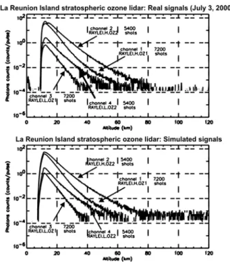
Given the known characteristics (temperature, and composition) of a typical middle atmosphere (called the “original profiles”), lidar signals with magnitude representative of the participating instruments are simulated (called the “simulated signals”) using the basic theoretical lidar equations for Rayleigh and Raman scattering (e.g., equation 7.14 in [5]). For example, typical real and simulated signals for the stratospheric DIAL-ozone lidar instrument in La Reunion Island (NDSC candidate) are shown in Fig. 1. The simulated signals are then sent to each participant in order to be processed by their ozone and/or temperature analysis algorithm. The results of the analysis (called “retrieved profiles”) are then compared to the “original profiles”. If discrepancies between the retrieved and original profiles are detected, an attempt is made to identify the sources of the discrepancies. If the source is identified, then the algorithm in question is corrected accordingly, and another set of simulated data is sent for reanalysis until no discrepancy remains. Because potential sources of discrepancy are numerous, the simulated data are generated in such a way that only one part of the analysis at a time is tested. In the particular case of Fig. 1 the simulated signals were created to be as close as possible to real signals, and therefore contain noise as well. In most cases the
simulated signals will not contain noise, so that the target issue during a given test can be easily identified. Those sources of discrepancy that are either easy to identify, or which assessment has been considered a priority are now detailed.
Fig. 1. Example of typical real (a) and simulated (b) signals for the stratospheric ozone lidar at La Reunion Island.
3. AIMS OF THE A2I
Following the general lidar equation theory, there are well known specific corrections to apply to the lidar signals in the retrieval of ozone and temperature. For temperature, these corrections are (1) the geometrical factor (known as the range2 correction), (2) the
Rayleigh extinction by the air molecules along the laser pulse round-trip path between the ground and the altitude considered, and (3) the ozone absorption along that same path. For ozone retrieval (differential absorption technique), corrections (1) and (2) are similar to that for temperature retrieval, and correction (3) is reduced to a problem of absorption cross-section differential. Because of the need for laboratory values of cross-sections, and the need to consider a priori atmospheric conditions (molecular density for (2), and ozone for (3)), these corrections can ultimately lead to significant differences in the retrieved products from one algorithm to the other. Also, though one may start with similar assumptions, and identical corrections (1)-(3), the use of differing vertical resolutions, and differing error assessments, can lead to significantly
different results in the final products. This is what the A2I is aimed to assess: Can the NDSC lidar participants find common grounds in their choice of cross-sections, and a priori assumptions? Can they find common grounds in using a “unique” definition of vertical resolution, and in defining a “unique” way of assessing errors and uncertainties?
Note that other lidar signal corrections, those exclusively connected to the instrument configuration and components such as pile-up effects, background and signal-induced noise, etc., are not within the priority aims of the A2I, because they are not easily controllable when using simulated signals. However, though errors due to these corrections cannot be assessed for each individual instrument, they can still be generally assessed using the simulated signals. Then, it is the participating science team’s role to use the general conclusions obtained using the simulations, to adequately assess issues associated with their own instrument.
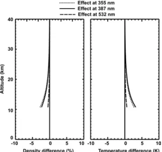
To illustrate some of the numerous possible effects of a priori information, we show in Fig. 2 the effect on retrieved temperature of a 10% overestimation of the Rayleigh section in the Rayleigh extinction cross-section.
Fig. 2. Difference between the retrieved and original temperature profiles if the Rayleigh extinction cross-section is overestimated by 10%.
Then, we show on Fig. 3 the effect on the ozone retrieval of the same 10% overestimation, depending on what wavelength(s) the overestimation was made. These two examples were taken from a past investigation using the same lidar signal simulation technique, and display the difference between the
retrieved and the original profiles. Similar results, this time applied to the specific A2I participating instruments, are anticipated. Note in the case shown that the effect of the 10% Rayleigh extinction overestimation is identical to the effect of a 10% systematic overestimation of the a priori molecular density used in the algorithm. This again illustrates the crucial importance of a priori assumptions, and the need for homogenizing them within the NDSC participants.
Fig. 3. Same as Fig. 2, but effect on ozone retrieval instead of temperature retrieval.
4. A2I PARTICIPANTS AND TIMELINE
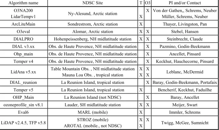
As a result of the September 2003 LWG meeting decision, the science/engineering groups of the 27 participating NDSC (or NDSC candidate) lidars have been contacted. Teams in charge of 23 instruments have responded, and expressed their interest in participating to the A2I. The initial stage of the A2I, which took place in late 2003-early 2004, consisted in gathering the instrumental characteristics of all the participating lidars.
The list of participants who took part to this initial stage is shown in table 1. Typical raw-signals have been generated following conditions that are as close as possible to the acquisition conditions of real signals (an example was shown in Fig. 1). Even the raw data format of the simulated signals has been kept identical to that of actual raw data whenever possible, in order to reenact the actual conditions of the NDSC routine data acquisition and analysis.
Algorithm name NDSC Site T O3 PI and/or Contact O3NA200
LidarTempv1 Ny-Alesund, Arctic station X
X Von der Gathen,, Schrems, Neuber Müller, Schrems, Neuber ArcLiteMain Sondrestrom, Arctic station X Thayer, Livingston, Pan
O3eval Alomar, Arctic station X X Stebel, Hansen
DIALPRO Hohenpeissenberg, NH midlatitude station X X Steinbrecht, Claude DIAL v3.xx Obs. de Haute Provence, NH midlatitude station X Pazmino, Godin-Beekmann
Ohp_main Obs. de Haute Provence, NH midlatitude station X Ancellet, Pinsard Temper v4 Obs. de Haute Provence, NH midlatitude station X Keckhut, Hauchecorne, Pinsard LidAna v5.xx Table Mountain Obs. , NH midlatitude station
Mauna Loa Obs. , tropical station
X X
X
X Leblanc, McDermid DIAL_reunion La Reunion Island, tropical station X Baray, Godin-Beekmann, Portafaix
Temper v5 La Reunion Island, tropical station X Bencherif, Keckhut, Faduilhe
OHP_Main La Reunion Island (not NDSC) X Baray, Ancellet
ozoneprofile_sin v8.1 Lauder, SH midlatitude station X X Meijer, Swart
Eval6 MARL (mobile) X Immler, Schrems
LiDAP v2.4.5, TFP v5.8 STROZ (mobile) AROTAL (mobile., not NDSC)
X X
X
Twigg, McGee, Sumnicht Table 1. Current list of A2I active participants.
Now that all the instrumental information has been gathered, the testing phase is to begin in March 2004. It will consist of sending noise-free simulated signals that contain only one correction at a time in order to detect possible discrepancies between the retrieved and original profiles that are related to that single correction. The corrections (1)-(3) listed above, as well as other data processing parts of the temperature and ozone algorithms will be successively targeted. A first outcome of the A2I will be presented at the ILRC meeting in July. More comparisons will be following, so that the bulk of the A2I assessment should take place in the second half of 2004.
ACKNOWLEDGMENTS
The work described in this paper was carried out at the Jet Propulsion Laboratory, California Institute of Technology, under an agreement with the National Aeronautics and Space Administration.
REFERENCES
1. McDermid, I. S., et al., OPAL: Network for the Detection of Stratospheric Change Ozone Profiler Assessment at Lauder, New Zealand. I. Blind Intercomparison, J. Geophys. Res., 103, 28,683-28692, 1998.
2. McPeters, R. D., et al., Results from the 1995 Stratospheric Ozone Profile Intercomparison at Mauna Loa, J. Geophys, Res., 104, 30,505 -30,514, 1999. 3. Leblanc, T., I.S. McDermid, A. Hauchecorne and P. Keckhut, Evaluation of optimization of lidar temperature analysis algorithms using simulated data, J.
Geophys. Res., 103, 6177-6187, 1998.
4. Godin, S., A. et al., DIAL Ozone Algorithm Intercomparison, Appl. Opt., 38, 6225-6236, 1999. 5. Measures, .R. M, Laser remote sensing:
Fundamentals and applications, Wiley-Interscience,