O R I G I N A L P A P E R
Jean-Pierre Berger Æ Bettina Reichenbacher Damien Becker Æ Matthias Grimm Æ Kirsten Grimm Laurent Picot Æ Andrea Storni Æ Claudius Pirkenseer Christian Derer Æ Andreas Schaefer
Paleogeography of the Upper Rhine Graben (URG) and the Swiss
Molasse Basin (SMB) from Eocene to Pliocene
Received: 23 October 2003 / Accepted: 1 December 2004 / Published online: 25 May 2005
Ó Springer-Verlag 2005
Abstract Twenty paleogeographic maps are presented for Middle Eocene (Lutetian) to Late Pliocene times accord-ing to the stratigraphical data given in the companion paper by Berger et al. this volume. Following a first lacustrine-continental sedimentation during the Middle Eocene, two and locally three Rupelian transgressive events were identified with the first corresponding with the Early Rupelian Middle Pechelbronn beds and the second and third with the Late Rupelian Serie Grise (Fis-chschiefer and equivalents). During the Early Rupelian (Middle Pechelbronn beds), a connection between North Sea and URG is clearly demonstrated, but a general connection between North Sea, URG and Paratethys, via the Alpine sea, is proposed, but not proved, during the late Rupelian. Whereas in the southern URG, a major hiatus spans Early Aquitanian to Pliocene times, Early and Middle Miocene marine, brackish and freshwater facies occur in the northern URG and in the Molasse Basin (OMM, OSM); however, no marine connections between these basins could be demonstrated during this time. After the deposition of the molasse series, a very complex drainage pattern developed during the Late Miocene and
Pliocene, with a clear connection to the Bresse Graben during the Piacenzian (Sundgau gravels). During the Late Miocene, Pliocene and Quaternary sedimentation per-sisted in the northern URG with hardly any interruptions. The present drainage pattern of the Rhine river (from Alpine area to the lower Rhine Embayment) was not established before the Early Pleistocene.
Keywords Rhine Graben Æ Molasse Æ Paleogene Æ Neogene Æ Paleogeography
Introduction
Several paleogeographic reconstructions were published for the URG and the Molasse Basin during the last 10 years (Berger 1996; Kuhlemann and Kempf 2002; Schlunegger and Pfiffner 2001; Sissingh 1998, 2003). Here, we present the results of 4 years of research car-ried out in the frame of the EUCOR-URGENT project, giving a very detailed paleogeographic frame of the studied area for Middle Eocene to Late Pliocene times. These maps were prepared according to the stratigraphic data published by Berger et al. in this volume. To avoid repetition and redundancy between the two papers, references pertaining to stratigraphic and facies data are generally not repeated here but can be found in the companion paper by Berger et al. (2004).
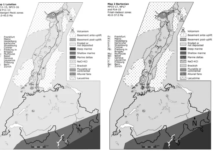
Eocene (Maps 1–3) Map 1 Lutetian
Lithostratigraphy (for details, see Berger et al.2004, this volume)
Helvetic and Subalpine Molasse: Steinbach/Gallensis Formation, Bu¨rgen Fm. and ?Klimsenhorn Fm., Sid-erolithic
J.-P. Berger (&) Æ D. Becker Æ A. Storni Æ C. Pirkenseer Department of Ge´osciences/Ge´ologie,
University of Fribourg-Pe´rolles, 1700 Fribourg-Suisse, Germany E-mail: [email protected] B. Reichenbacher
Institut fu¨r Pala¨ontologie der Universita¨t Mu¨nchen, Richard-Wagner-Strasse 10,
80333 Mu¨nchen, Germany M. Grimm Æ K. Grimm
Institut fu¨r Geowissenschaften der Universita¨t Mainz, 55099 Mainz, Germany
L. Picot
Austrian Academy of Sciences, Institute of limnology, Mondseestrasse 9, 5310 Mondsee-Austria, Germany C. Derer Æ A. Schaefer
Geologisches Institut, Universita¨t Bonn, Nussallee 8, 53115 Bonn, Germany
Plateau and Jura Molasse: Siderolithic
Southern and middle URG: Siderolithic, Eoza¨ner Basistone, URG-conglomerates and breccias (‘‘Stein-gang’’), Bouxwiller Fm. (= Planorbenkalke and Calc-aires d’eau douce ‘‘Lute´tiens’’), Green Marls (= Lymneenmergel, Marnes vertes, Gru¨ne Mergel), Salife`re infe´rieur, Lower Salt Fm.
Northern URG and Mainz Basin: Messel Formation, Eoza¨ner Basiston, Unreine Sand- und Tonschichten, A¨ltere Eisenberger Tonfolge, Green Marls (=Lymn-eenmergel, Gru¨ne Mergel, Eisenberger Gru¨nton) (see Fig.1).
Map 2 Bartonian
Lithostratigraphy (for details, see Berger et al.2004, this volume)
Helvetic and Subalpine Molasse: Wildstrubel and Klimsenhorn Formation, ?Globigerinenmergel, Hoh-gant Formation (base), Siderolithic
Plateau and Jura Molasse: Siderolithic
Southern and middle URG: URG-conglomerates (‘‘Steingang’’), Green Marls (=Lymneenmergel, Marnes vertes, Gru¨ne Mergel), Salife`re infe´rieur, Lower Salt Fm.
Northern URG and Mainz Basin: ?Eoza¨ner Basiston, Green Marls (=Lymneenmergel, Gru¨ne Mergel, Eisen-berger Gru¨nton) (see Fig.2).
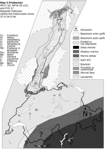
Map 3 Priabonian
Lithostratigraphy (for details, see Berger et al.2004, this volume)
Helvetic and Subalpine Molasse:Wildstrubel Forma-tion (top), Globigerinenmergel, Flysch sudhelve´tique, Marnes a` foraminife`res, Hohgant Fm., Calcaires a` pe-tites nummulites, Cerithium beds, Couches a` Ce´ri-thies,Couches a` Diablerets, Sanetsch Fm., ?Siderolithic? Plateau and Jura Molasse: Siderolithic, ??base Gelb-erde and Raitsche
Southern and middle URG: URG-conglomerates (‘‘Steingang’’), ?Conglom. de Porrentruy, Green Marls (=Lymneenmergel, Marnes vertes, Gru¨ne Mergel with Melanienkalke), Salife`re infe´rieur, Lower Salt Fm., Rote Leitschicht, Zone dolomitique, Lower Pechelbronn beds
Northern URG and Mainz Basin: Green Marls (=Lymneenmergel, Marnes vertes, Gru¨ne Mergel, Eisenberger Gru¨nton), Rote Leitschicht (incl. Sandige Eisenberger Decktone), Lower Pechelbronn beds and Eisenberger Klebsand (see Fig.3).
During the Lutetian, the Alpine sea was located in the area northern Italian and southern Switzerland, with its northern shoreline about 70 km south of Bern (Sis-singh 1998). The Alpine front was probably situated about 300 km south of its present position (De`zes et al.
2004). Most of the area of present Switzerland was dominated by erosion (marked by local siderolithic deposits). In the URG, sedimentation occurred locally, with small lakes (e.g. Messel or Bouxwiller) and local fluviatile deposits. The first halites accumulation (mainly in the Mulhouse–Colmar area) probably began at this time.
They are no major changes during the Bartonian. In the URG, it is not clear whether sedimentation was persistent or was interrupted at this time, as postulated by Sissingh (1998).
During the Priabonian, the URG was affected by a first rifting phase that was responsible for the develop-ment of large conglomeratic fans along both the eastern and western, as well as the southern graben margins.
The axis of the evolving URG was occupied by the Salt basins in its southern, brackish (with local salt) to lacustrine in its middle-, and fluviatile to lacustrine in its northern part, as well as in the Mainz Basin.
Early Oligocene, Rupelian (Maps 4–6) Map 4 Early Rupelian
Lithostratigraphy (for details, see Berger et al.2004, this volume):
Helvetic and Subalpine Molasse: UMM Meletta shales, Taveyannaz and Aldorf sandstones, Val d’Illiez Fm.
Plateau and Jura Molasse: Calcaires infe´rieurs, Krustenkalk, Gelberde, Raitsche,
Southern and middle URG: Conglom. de Porrentruy, URG-conglomerates and breccias (‘‘Steingang’’), Mid-dle Pechelbronn beds (=Zone fossilife`re), Plattige Steinmergel, Marnes et calcaires en plaquette, ? Salifere moyen, ?Middle Salt Fm.
Northern URG and Mainz Basin: Middle Pechel-bronn beds and Ebertsheim Fm (see Fig. 4).
Map 5 Middle Rupelian
Lithostratigraphy (for details, see Berger et al.2004, this volume)
Helvetic and Subalpine Molasse: UMM Vaulruz Fm., Grisiger Mergel and Horwer Sandstein
Plateau and Jura Molasse: Calcaires infe´rieurs, Krustenkalk, Gelberde, Raitsche
Southern and middle URG: ??Conglom. de Porren-truy, URG-conglomerates and breccias (‘‘Steingang’’), Salifere sup., Upper Salt Fm., Haustein (pars), Upper Pechelbronn beds
Northern URG and Mainz Basin: Upper Pechel-bronn beds (see Fig. 5).
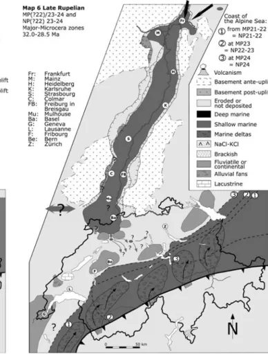
Map 6 Late Rupelian
Lithostratigraphy (for details, see Berger et al.2004, this volume)
Helvetic and Subalpine Molasse: UMM Vaulruz Fm., Grisiger Mergel & Horwer Sandstein, USM Mo-lasse rouge, Beichlen Fm.
Plateau and Jura Molasse: Calcaires infe´rieurs, Kru-stenkalk, Molasse alsacienne, Fischschiefer, Septarien-ton, Meeressand, Foraminiferenmergel,UMM ?Vaulruz Formation, Horwer Sandstein?, USM untere Bunte Mergel
Southern and middle URG: Molasse alsacienne, URG-conglomerates (‘‘Steingang’’), ‘‘Serie grise’’, (Rupelton, Foraminiferenmergel, Fischschiefer, Meletta-beds, Cyrenenmergel, etc.), Alzey Fm., Bodenheim Fm.
Northern URG, Mainz and Hanau Basins: ‘‘Serie grise’’, (Rupelton, Foraminiferenmergel, Fischschiefer, Oberer Rupelton, Meletta beds, Cyrenenmergel), Alzey Fm, Bodenheim Fm., Stadecken Fm., Sulzheim Fm. (pars) (see Fig.6).
The beginning of the Rupelian (Map 4) was marked by a general transgression coming from the North Sea, corresponding to the Middle Pechelbronn beds. The sea ended in the southern URG, where the Streifige Mergel and the Haustein show the transition from marine to brackish and then to lacustrine conditions. The Molasse of the Jura Mountains was apparently not affected by this transgression. Moreover, no connection existed at this time between the marine Pechelbronn beds and the
Perialpine marine Molasse. This is perhaps due to the relief along the southern margin of the URG, as evi-denced by the occurrence of large amounts of con-glomerates (e.g. in the area of Porrentruy). At this time, the first pebbles derived from the Vosges basement were observed, indicative of uplift of the southern Vosges massif (Picot et al. 2004).
During the Middle Rupelian (Map 5), marine con-nections between the North Sea and the URG were interrupted, leading to the development of lacustrine (in the North) and brackish basins (South), with the well-known Upper salt basins (KCl). During this time, the perialpine sea (UMM) was not connected with the Rhine graben.
A general marine transgression invaded then the en-tire URG-basin during the Late Rupelian (Map 6), giv-ing rise to the deposition of the Se´rie grise (Meletta shales, Fischschiefer and other synchronous formations, see Berger et al., this volume). During this time, the Al-pine sea regresses towards the East. It is likely that during this time a marine connection existed between the Alpine foreland and the URG (perhaps during NP 23?) but its precise position is not known (see Berger1996; Kuhle-mann and Kempf 2002). As shown on Map 6, the regression of the Alpine sea occurred between 32 Ma and
29 Ma (see also Diem 1986; Berger 1995; Picot 2002). Thus, a marine connection between URG and Molasse Basin was only possible via the central and eastern part of the Swiss Molasse Basin (corresponding to the coast lines 2 and 3 on Map 6), as its western part was already covered by fluviatile sediments (USM, with mammals, see Berger1992and1996).
Kuhlemann et al. (1999) proposed Late Rupelian transport of clastic material from the Molasse Basin into the Southern Rhine graben, based on fission tracks-cooling age spectra of detrital apatites and zircon crystals. The precise stratigraphic position of this transport is unfortunately still insufficiently con-strained.
Late Oligocene, Chattian (Maps 7–9) Map 7 Early Chattian
Lithostratigraphy (for details, see Berger et al.2004, this volume):
Helvetic and Subalpine Molasse: USM Molasse rouge, Uerscheli Formation, Schwa¨ndibach conglom., Granitic Molasse Formation, Homberg beds
Plateau and Jura Molasse: UMM Top Bausteins-chichten, Calcaires infe´rieurs, Krustenkalk, Molasse alsacienne, Top Septarienton, USM untere Bunte Mergel Southern and middle URG: Molasse alsacienne, Niederroedern beds, Freshwater beds, Lower Cerithium beds
Northern URG, Mainz and Hanau Basins: Nieder-roedern beds, Budenheim-Fm., Sulzheim Fm. (pars) (see Fig. 7).
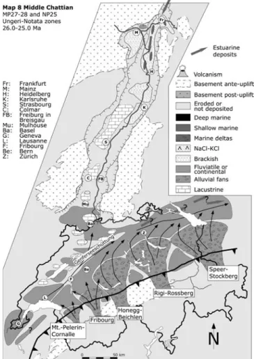
Map 8 Middle Chattian
Lithostratigraphy (for details, see Berger et al.2004, this volume)
Helvetic and Subalpine Molasse: USM Molasse rouge, Mt. Pelerin Fm., Losenegg Fm., ?Schwa¨ndibach conglom., Thun conglom., Honegg marls
Plateau & Jura Molasse: ??Calcaires infe´rieurs, Molasse alsacienne, ? Calcaires dele´montiens? (base), USM untere Bunte Mergel
Southern and middle URG: Niederroedern beds, Freshwater beds, Lower Cerithium beds, Tu¨llingen Formation (base)
Northern URG, Mainz and Hanau Basins: ? Nie-derroedern beds, Lower Cerithium beds, Budenheim Formation, Sulzheim Fm (pars) (see Fig.8).
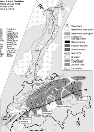
Map 9 Late Chattian
Lithostratigraphy : (for details, see Berger et al. 2004, this volume)
Helvetic and Subalpine Molasse: USM Conglomer-ates, Honegg marls, Gitzischo¨pf conglom., Molasse a` charbon
Plateau and Jura Molasse: USM Calcaires et Dolo-mies??, USM Gre`s et Marnes grises a` gypse (GMGG), Calcaires dele´montiens
Southern and middle URG: Tu¨llingen Fm., Middle Cerithium beds, Upper Cerithium beds (pars)
Northern URG, Mainz and Hanau Basins: Middle Cerithium beds and Landschneckenkalk, Oppenheim Fm (see Fig.9).
During the Early Chattian (Map 7), following the regression of the UMM towards the East, fluvial sedi-ments prevailed in the Swiss Molasse Basin. Alluvial conglomeratic fans derived from the Alps were drained by a SW–NE fluviatile system referred to as the Gen-ferseeschu¨ttung. Part of this system invaded the southern URG through the Jura Molasse, as attested by heavy minerals of the so-called Molasse Alsacienne (Picot2002). Lacustrine sediments prevailed in the Middle URG, whereas its northern part, including the Mainz basin, was dominated by brackish and lacustrine sediments.
During the Middle Chattian (Map 8), conditions as established during the Early Chattian prevail in the Swiss Molasse Basin. In the Northern URG, a brackish to marine ingression, probably derived from the North Sea, is recognized (Reichenbacher2000; Sissingh2003). The Late Chattian (Map 9) shows an important de-crease in clastic supply to the western Molasse Basin, resulting in the development of lacustrine and brackish conditions, as attested by the accumulation of lacustrine limestones and gypsiferous marls (Molasse a` charbon, Calcaires et Dolomies, Gre`s et marnes gris a` gypse). The southern and middle part of the URG were dominated by lacustrine conditions (Niederroedern beds, Lower Cerithium beds) whereas the in the northern URG brackish sediments, with local important salt accumu-lations, prevailed.
The differences observed between the map of Kuh-lemann and Kempf (2002) (plate 2) and the maps pre-sented here (Maps 7–9) are principally an effect of time resolution: the map of Kuhlemann and Kempf presents a combination of our Maps 7–9 and is more interpre-tative (e.g. concerning the connection with the Bresse Graben).
Early Miocene, Aquitanian and Burdigalian (Maps 10–13) Map 10 Early Aquitanian
Lithostratigraphy (for details, see Berger et al.2004, this volume)
Helvetic ans Subalpine Molasse: end of USM con-glomerates (e.g. Gitzischof congl.)
Plateau and Jura Molasse: USM Gre`s et Marnes grises a` gypse (GMGG), Calcaires dele´montiens?
USM Molasse grise de Lausanne (and local con-glomerates), Gunten Quartzite conglom., Granitische Molasse, obere Bunte Mergel (and sandstones)
Southern and middle URG: Upper Cerithium beds, Oberrad Formation
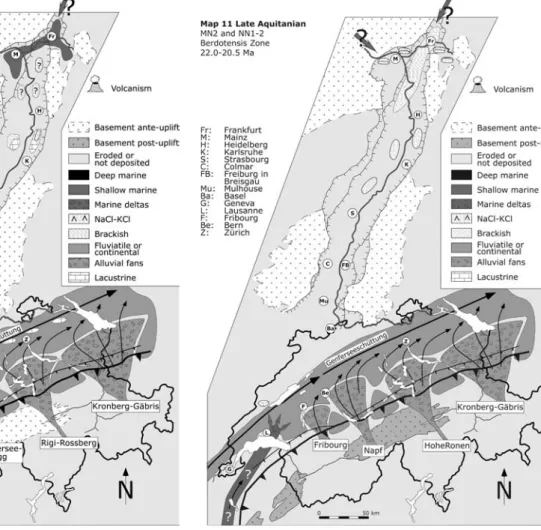
Northern URG, Mainz and Hanau Basins: Upper Cerithium beds, Oberrad Formation (see Fig. 10). Map 11 Late Aquitanian
Lithostratigraphy (for details, see Berger et al.2004, this volume)
Helvetic and Subalpine Molasse: no sedimentation Plateau and Jura Molasse: USM Molasse grise de Lausanne (and local conglomerates), Gunten Quartzite conglom., Granitische molasse, obere Bunte Mergel (and sandstones), Calcaires de La Chaux, OMM
Southern and middle URG: Inflata beds and Lower Hydrobia beds
Northern URG, Mainz and Hanau Basins: Ru¨ssin-gen Fm. (= Inflata beds) and Wiesbaden Formation (see Fig.11).
Map 12 Early Burdigalian
Lithostratigraphy (for details, see Berger et al.2004, this volume)
Helvetic and Subalpine Molasse: no sedimentation Plateau and Jura Molasse: OMM (Sense Fm. and Luzern Fm.) and Freshwater proximal conglomerates (e.g. Gunten Quartzite Conglom.)
Southern and middle URG: ?Lower Hydrobia beds, ?Landscheckenmergel
Northern URG, Mainz and Hanau Basins: Wiesba-den Formation, Upper Hydrobia beds, Niederrad Formation (= Landscheckenmergel), Jungtertia¨r I (base) (see Fig.12).
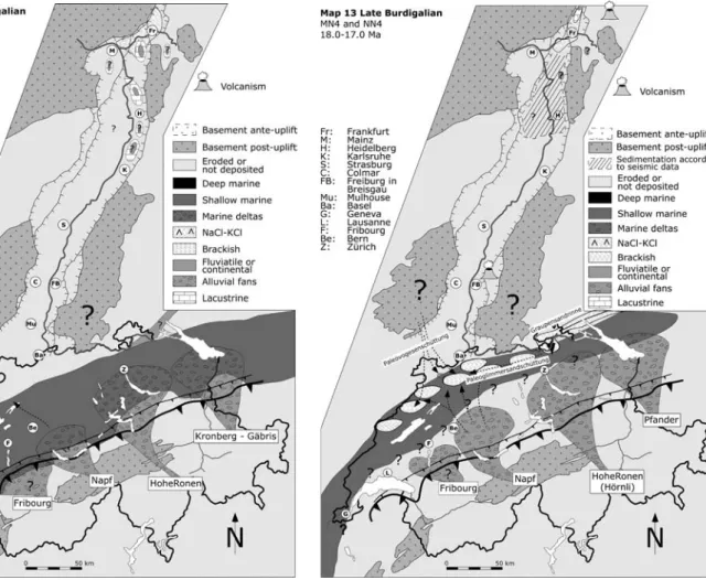
Map 13 Late Burdigalian
Lithostratigraphy (for details, see Berger et al.2004, this volume)
Helvetic and Subalpine Molasse: no sedimentation Plateau and Jura Molasse: OMM (?top of Belpberg Fm., St.-Gall Fm.), OSM (conglomerates), OMM-OSM transition, Marnes rouges, Rote Mergel, Helicidenmer-gel, Graupensandrinne
Southern and middle URG: JungTertia¨r I
Northern URG and Hanau Basin: Praunheim For-mation, JungTertia¨r I (see Fig.13).
During the Aquitanian (Maps 10 and 11), accumu-lation of alluvial clastic continued in the Swiss Molasse Basin, with local lacustrine and brackish deposits pre-vailing in its distal parts. The occurrence of a marine ingression in its western parts is attested by mammal
faunas (MN2a) trapped in tidal deposits (Berger1985). Marine ingressions coming from the North are clearly evident in the northern URG (Ru¨ssingen Fm. and basal Wiesbaden Fm.).
Kuhlemann and Kempf (2002) proposed in their plate 3 brackish and lacustrine facies in the southern URG and Bresse grabens. We do not agree with this interpretation, as no dated sediments are known from this area during this time, which probably corresponds to a period of erosion (Becker2003; Berger et al. (2004), this volume).
During the Burdigalian (Map 12), a marine ingres-sion originating from W is evident in the entire Molasse Basin. Modalities of this transgression were discussed in detail by several authors (Berger1985,1996; Kuhlemann and Kempf2002).
In contrast to Kuhlemann and Kempf (2002) (plate 4), most of the northern URG sediments of this interval are brackish, as attested by the Wiesbaden-Fm and Upper Hydrobia beds dated as MN3 (see Berger et al. (2004), this volume).
During the Late Burdigalian (Map 13), the Molasse Sea probably regresses towards the distal part of the basin, where brackish conditions prevailed (Marnes rouges, Helicidenmergeln, see Becker2003). An
tant estuary is evident in the NE, the so-called Grau-pensandrinne (see Reichenbacher et al. 1998).
In the northern parts of the URG, fluviatile, lacus-trine and brackish sediments are attributed to the Jungtertia¨r I (North URG) and the Praunheim Forma-tion (Hanau Basin). In the Mainz Basin, late Burdiga-lian sediments are missed.
Reflexion seismic data, calibrated by wells, show that south of the city of Speyer, a regional erosional uncon-formity of about mid-Burdigalian age cuts southward progressively deeper into Early Burdigalian and Oligo-cene sediments. This unconformity is related to uplift of the Vosges-Black Forest arch, including the southern part of the URG (Roll1979; De`zes et al.2004).
Middle to Late Miocene (Maps 14–17) Map 14 Late Langhian
Lithostratigraphy (for details, see Berger et al.2004, this volume)
Helvetic and Subalpine Molasse: no sedimentation Plateau and Jura Molasse: OSM (conglomerates), OMM–OSM transition, Marnes rouges, Rote Mergel, Helicidenmergel, OSM (base Glimmersand), Calcaires de Vermes
Southern and middle URG: JungTertia¨r II (basal part)
Northern URG and Hanau Basin: Staden Fm, Main Trapp, Bockenheim Fm., Salzhausen beds, JungTertia¨r II (basal part) (see Fig.14).
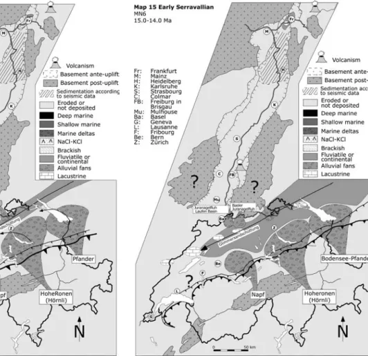
Map 15 Early Serravallian
Lithostratigraphy (for details, see Berger et al.2004, this volume)
Helvetic and Subalpine Molasse: no sedimentation Plateau and Jura Molasse: OSM (conglomerates), OSM Glimmersand, JuraNagelfluh s.l.
Southern and middle URG: Heubergschotter? Northern URG and Hanau Basin: ?JungTertia¨r II (basal part) (see Fig.15).
Map 16 Middle Serravallian
Lithostratigraphy (for details, see Berger et al.2004, this volume)
Helvetic and Subalpine Molasse: no sedimentation Plateau and Jura Molasse: OSM (conglomerates), OSM (‘‘Oeningian’’) and ?Glimmersand (top), Anwilerkalke, JuraNagelfluh s.l.
Southern and middle URG: Heubergschotter? Northern URG, Mainz and Hanau Basins: no sedi-mentation (see Fig.16).
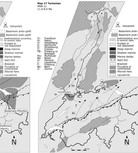
Map 17 Tortonian
Lithostratigraphy (see more details in Berger et al.2004, this volume)
Helvetic and Subalpine Molasse: no sedimentation Plateau and Jura Molasse: Hegau and Ho¨wenegg serie, Vogesensande, Hipparionsande, Dinotheriensand, ?Wanderblock Fm. ?
Southern and middle URG: Heubergschotter?, Hipparionsande, Dinotheriensand,
Northern URG, Mainz and Hanau Basins: Lauters-heim Fm., Dinotheriensand, Dorn-Du¨rkLauters-heim Fm., Bohnerzton (see Fig.17).
These maps were already discussed by D. Becker and J.P. Berger (submitted) in the frame of the EEDEN program; here, we repeat only the principal events occurring during this time span.
During the Langhian (Map 14), a NE-SW fluviatile drainage (so-called Glimmersand) drained the distal part of the Molasse Basin. Alluvial fans coming from the Alps (Napf, Ho¨rnli and Bodensee-Pfander) are only evident in central and eastern Switzerland and adjacent Bavaria (see Kuhlemann and Kempf 2002). All these deposits form the OSM.
Equivalent sediments are unknown for the western part of the Molasse Basin when 2,000 m of Miocene sediments were probably eroded during the Plio-Pleis-tocene (Kuhlemann and Kempf2002).
Only punctual relicts of Langhian deposits occur in the western Jura Molasse (see Ka¨lin et al. 2001) dis-playing a brackish-marine facies (NN4-NN5). In the northern URG, the sedimentation is essentially conti-nental, brackish and lacustrine. In the Mainz Basin, Langhian sediments are missed.
In conjunction with progressive uplift of the Vosges-Black Forest arch, the central and southern part of the URG were subjected to erosion.
During the Serravallian (Maps 15–16), the fluviatile sedimentation of the OSM continued, with an important clastic supply coming from the Vosges and Black Forest massifs, confirming continued uplift during this time.
Although no sediments dated as Middle and Late Serravallian are known in the URG (?possible remnants near Frankfurt ?), their presence in its northern parts is indicated by reflection seismic data.
The Tortonian (Map 17) is principally known by conglomeratic and sandy alluvial deposits coming from the Vosges and Schwarzwald massifs (fossil localities Charmoilles, Nebelberg, Ho¨wenegg) in the southern URG, by the Dinotheriensand and by the Dorn-Du¨rk-heim beds (only Mainz Basin). The Dinotheriensande of the northern URG and the Mainz Basin were deposited by an Upper Rhine coming from the northern Vosges and Schwarzwald massifs (Bartz 1961; Abele
1977).
The Tortonian drainage pattern is very difficult to reconstruct; a general W–E drainage of the Molasse basin was proposed by several authors (Giamboni et al.
2004; Kuhlemann and Kempf 2002; Liniger 1966; Petit et al. 1996; Schlunegger et al. 1998), generally based on the uplift of the western and central parts of the Molasse Basin in conjunction with folding of the Jura Mountains.
Pliocene (Maps 18–20)
Map 18 Early Pliocene (Early Zanclean)
Lithostratigraphy : ?51, see Berger et al.2004, this vol-ume
Helvetic and Subalpine Molasse: no sedimentation Plateau and Jura Molasse: ?Wanderblock Form. ? Southern and middle URG: ‘‘Pliocene not differen-tiated’’
Northern URG, Mainz and Hanau Basins: Karst infills, White Mio-Pliocene, Klebsand, ‘‘Pliocene not differentiated’’, Jungtertia¨r II (see Fig.18).
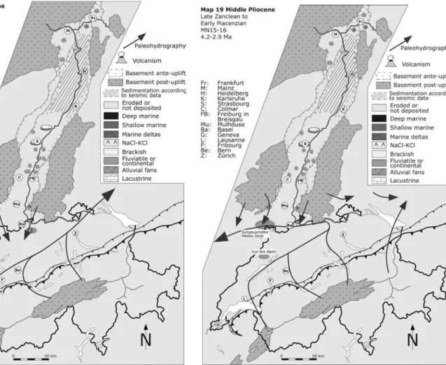
Map 19 Early to Late Pliocene (Late Zanclean to Early Piacenzian)
Lithostratigraphy : 24, 31, 51, see Berger et al.2004, this volume
Helvetic and Subalpine Molasse: no sedimentation Plateau and Jura Molasse: Karst Vue des Alpes, Sundgauschotter and Argiles de Bonfol, Weiße Serie
Southern and middle URG: Sundgauschotter and Argiles de Bonfol, Weiße Serie, ‘‘Pliocene not differen-tiated’’
Northern URG, Mainz and Hanau Basins: Karst infills, arvernensis-Schotter, Plioza¨n I-III, ‘‘Pliocene not differentiated’’, Jungtertia¨r II (see Fig. 19).
Map 20 Late Pliocene (Late Piacenzian to Early Gelasian)
Lithostratigraphy : 50, 51, see Berger et al. 2004, this volume
Helvetic and Subalpine Molasse: no sedimentation Plateau and Jura Molasse: A¨ltere Deckenschotter Southern and middle URG: ‘‘Pliocene not differen-tiated’’
Northern URG, Mainz and Hanau Basins: Karst infills, arvernensis-Schotter, A¨ltere Weisenauer Sande, ‘‘Pliocene not differentiated’’, Jungtertia¨r II (see Fig.20).
Messinian sediments were not identified in the whole URG region as well as in the Molasse. Probably, some Bohnerz clays were deposited in the Mainz Basin.
During the Early Pliocene (Map 18), the continental conditions probably prevailed; as no fossil localities are known from this time, it is not possible to detail depo-sitional environments, areas of sedimentation and the drainage pattern. In the URG, important sediments considered as Pliocene in the literature are known from several areas, (mainly between Colmar and Stras-bourg) although they are not precisely dated (see Berger et al.2004in this volume).
During the Late Zanclean–Early Piacenzian (Map 19), an abrupt change of the drainage pattern is marked by the occurrence of the Sundgau gravels in the south, as well as by the arvernensis gravels in the north. Most of the Alpine-derived deposits were transported towards the North and Northeast area, then towards the West into the Bresse Graben. The Eastern part of the Alpine system was probably still drained towards the East (Giamboni et al. 2004; Liniger 1966; Petit et al. 1996).
The drainage pattern presented on Map 20 is still being disputed: most of the authors (Giamboni et al.
2004; Mu¨ller et al. 2002; Petit et al. 1996) proposed a general pattern of the Thurtal-Rheintal-Glatttal Schu¨t-tung towards the West and then into the URG, according to the data of the Ho¨here Deckenschotter (Bolliger et al. 1996; Graf 2003) and heavy mineral investigations in the northern URG (Semmel1983; Bo-enigk1982). However, some authors (D. Ellwanger, oral communication) do not agree with this interpretation and argue that this drainage pattern was only estab-lished with the deposition of the Lower Freiburg beds circa 800,000 years ago.
Note that first Alpine heavy minerals appear in the Lower Rhine graben at the Plio-Quaternary transition (Boenigk2002; Heumann and Litt2002).
Conclusion
The maps presented here have to be considered as a working document. Several questions are still open, as for example
– the precise timing, localisation and origin of the Salt deposits during the Eocene
– the precise relationships between the different forma-tions occurring in the South URG between the Late Eocene and the Early Oligocene (and especially the prolongation of the Pechelbronn beds towards the South)
– the relationships between URG, Molasse and Bresse Graben during the Late Rupelian
– the lack of sedimentation in the South URG during the Early and middle Miocene
– the drainage pattern during the Late Miocene and Early Pliocene
It is to be noted that no map was proposed here for the Messinian, a crucial period for the circum Mediter-ranean area. It was not possible, at this state of knowl-edge, to distinguish between a possible effect of the regressive erosion on the Molasse basin and the tectonic uplift generally proposed for this period.
Acknowledgements We thank D. Ka¨ lin (Bern), M. Hottenrott and G. Radtke (Wiesbaden), T. Griessemer (Mainz), M. Lutz (Freiburg im Br.), W. Sissingh (Utrecht) for stimulating discussion. We are grateful to P.A. Ziegler (Basel) and J. Kuhleman (Tu¨bingen) for their comments, which helped improve this paper. Financial sup-port by the Swiss National Science Foundation, projects 21.52359.97, 20.59220.99 & 20–66935.01, as well as by the EUCOR-URGENT-Project, is gratefully acknowledged.
References
Abele G (1977) Morphologie und Entwicklung des Rheinsystems aus der Sicht des Mainzer Raumes. Mainzer geographische Studien 11:245–259 Mainz
Bartz J (1961) Die Entwicklung des Flußnetzes in Su¨dwestdeutschland. Jahreshefte des Geologischen Landesam-tes Baden-Wu¨rtemberg 4:127–135 Freiburg i. Br
Becker D (2003) Pale´oe´cologie et pale´oclimats de la Molasse du Jura (Oligo-Mioce`ne): apport des Rhinoceratoidea (Mammalia) et des mine´raux argileux. The`se Univ Fribourg, Geofocus 9:1–327 Berger JP (1985) La transgression de la Molasse marine supe´ri-eure (OMM) en Suisse occidentale. Mu¨nchn geowiss Abh A5:1–207
Berger JP (1992) Pale´ontologie de la Molasse de Suisse occidentale. The`se d’habilitation Univ Fribourg 25.05.1992, pp 1–450 Berger JP (1995) Des nannofossiles calcaires aux rhinoce´ros:
de´-place´s au remanie´s?. Eclogae geol Helv 88(3):657–680
Berger JP (1996) Cartes pale´oge´ographiques-palinspastiques du bassin molassique Suisse (Oligoce`ne infe´rieur-Mioce`ne moyen). N Jb Min Geol Pal Abh 202(1):1–44
Berger JP, Reichenbacher B, Becker D, Grimm M, Grimm K, Picot L, Storni A, Pirkenseer C, Schaefer A (2004) Eocene-Pliocene time scale and stratigraphy of the Upper Rhine Graben (URG) and the Swiss Molasse Basin (SMB). Int J Earth Sci, this volume Boenigk W (1982) Der Einfluß des Rheingraben-Systems auf die Flußgeschichte des Rheins. Zeitschrift fu¨r Geomorphologie, Supplementband, vol 42. Stuttgart, Berlin, pp 167–175 Boenigk W (2002) The Pleistocene drainage pattern in the Lower
Rhine Basin. In: Rift tectonics and syngenetic sedimentation; the Cenozoic Lower Rhine Basin and related structures. Netherlands J Geosci 81(2):201–209
Bolliger T, Fejfar O, Graf H, Kaelin D (1996) Vorla¨ufige Mittei-lung u¨ber Funde von plioza¨nen Kleinsa¨ugern aus den ho¨heren Deckenschottern des Irchels (Kt. Zu¨rich). Eclogae geol Helv 89(3):1043–1048
De`zes P, Schmid S, Ziegler PA (2004) Evolution of the European Cenozoic Rift System: interaction of the Alpine and Tyrenean orogens with their foreland lithosphere. Tectonophysics (in press)
Diem B (1986) Die Untere Meeresmolasse zwischen der Saane und Ammer. Eclogae geol Helv 79(2):493–559
Giamboni M, Ustaszewski K, Schmid SM, Schumacher ME, Wetzel A (2004) Plio-Pleistocene transpressional reactivation of paleozoic and paleogene structures in the Rhine-Bresse trans-form zone (northern Switzerland and eastern France). Int J Earth Sci (accepted)
Graf HR (2003) Geschichte des unteren Thurtales. Mitt der Thurgauischen Naturforsch Ges 59:7–30
Heumann G, Litt T (2002) Stratigraphy and paleoecology of the Late Pliocene and Early Pleistocene in the open-cast mine Hambach (Lower Rhine basin). In: Schaefer A, Siehl A (eds) Rift tectonics and syngenetic sedimentation; the Cenozoic Lower Rhine Basin and related structures. Geologie en Mijn-bouw. Neth J Geosci 81(2):193–199
Ka¨lin D, Weidmann M, Engesser B, Berger J-P (2001) Pale´on-tologie et aˆge de la Molasse d’eau douce supe´rieure (OSM) du Jura neuchaˆtelois. Me´moires suisses de pale´ontologie 121:65– 99
Kuhlemann A, Kempf O (2002) Post-eocene evolution of the North Alpine Foreland Basin and its response to Alpine tectonics. Sediment Geol 152:45–78
Kuhlemann J, Spiegel C, Dunkl I, Frisch W (1999) A contribution to the middle Oligocene paleogeography of Central Europe: new evidence from fission tracks ages of the Southern Rhine graben. N Jb Geol Palaeontol Abh 214:415–432
Liniger H (1966) Das plio-altpleistoza¨ne Flussnetz der Nord-schweiz. Regio Bas 7(2):158–177
Mu¨ller WH, Naef H, Graf HR (2002) Geologische Entwicklung der Nordschweiz, Neotektonik und Langzeitszenarien Zu¨rcher Weinland. NAGRA technischer bericht 99–08, p 237
Petit C, Campy M, Chaline J, Bonvalot J (1996) Major paleogeo-graphic changes in Alpine Foreland during the Plio-cene—Pleistocene. Boreas 25:131–143
Picot L (2002) Le Pale´oge`ne des synclinaux du Jura et de la bordure sud-rhe´nane: pale´ontologie (Ostracodes), pale´oe´cologie, biostratigraphie et pale´oge´ographie. The`se Univ Fribourg, Geofocus 5, pp 1–240
Picot L, Becker D, Lapaire F, Ustaszewski K, Hug WA, Berger JP (2004) Se´dimentologie, pale´ontologie et pale´oenvironnements coˆtiers de la re´gion de Porrentruy (sud - rhe´nan): implications ge´odynamique. Eclogae geol Helv (accepted)
Reichenbacher B (2000) Das brackish-lakustrine Oligoza¨n und UnterMioza¨n im Mainzer Becken und Hanauer Becken: Fischfaunen, Pala¨oo¨kologie, Biostratigraphie, Pala¨ogeogra-phie. Cour Forschung Senckenberg 222:1–143
Reichenbacher B, Bo¨ttcher R, Bracher H, Doppler G, von Engel-hardt W, Gregor HJ, Heissig K, Heizmann EPJ, Hofmann F, Ka¨lin D, Lemcke K, Luterbacher H, Martini E, Pfeil F, Reiff W, Schreiner A, Steininger FF (1998) Graupensand-rinne—Ries-Impakt: Zur Stratigraphie der Grimmelfinger Schichten, Kirchberger Schichten und Oberen Su¨sswassermo-lasse (no¨rdliche VorlandmoSu¨sswassermo-lasse, Su¨ddeutschland). Z dt geol Ges 149(1):127–161
Roll A (1979) Versuche einer Volumenbilanz der Oberhreingrabens und seiner Schultern. Geol Jb Riehe A, vol 52. p 82
Schlunegger F, Pfiffner A (2001) The sedimentary response of the North Alpine Foreland basin to changes in erosional processes in the Alps. IAS 2001, 21st Meeting, Davos, 3–5 September 2001. Excursion guides, pp 85–99
Schlunegger F, Slingerland R, Matter A (1998) Crustal thickening and crustal extension as controls on the evolution of the drainage network of the central Swiss Alps between 30 Ma and the present: constraints from the stratigraphy of the North Alpine Foreland Basin and the structural evolution of the Alps. Basin Res 10(2):197–212
Semmel A (1983) Die plio-pleistoza¨nen Deckschichten im Steinb-ruch Mainz-Weisenau—Geologisches Jahrbuch Hessen 111:219–233 Wiesbaden
Sissingh W (1998) Comparative Tertiary stratigraphy of the Rhine graben, Bresse graben and Molasse basin: correlation of Alpine foreland events. Tectonophysics 300:249–284
Sissingh W (2003) Tertiary paleogeographic and tectonostrati-graphic evolution of the Rhenish Triple Junction. Paleogeogr Paleoclimatol Paleoecol 196:229–263