HAL Id: hal-00968556
https://hal.archives-ouvertes.fr/hal-00968556
Submitted on 2 Apr 2014
HAL is a multi-disciplinary open access
archive for the deposit and dissemination of
sci-entific research documents, whether they are
pub-lished or not. The documents may come from
teaching and research institutions in France or
abroad, or from public or private research centers.
L’archive ouverte pluridisciplinaire HAL, est
destinée au dépôt et à la diffusion de documents
scientifiques de niveau recherche, publiés ou non,
émanant des établissements d’enseignement et de
recherche français ou étrangers, des laboratoires
publics ou privés.
avalanche hazard assessment in the French Alps
R. Schläppy, V. Jomelli, N. Eckert, M. Stoffel, D. Grancher, D. Brunstein, C.
Corona, M. Deschatres, M. Naaim
To cite this version:
R. Schläppy, V. Jomelli, N. Eckert, M. Stoffel, D. Grancher, et al.. Contribution of
dendrogeomor-phology in the field of avalanche hazard assessment in the French Alps. International Snow Science
Workshop (ISSW), Oct 2013, Grenoble - Chamonix Mont-Blanc, France. p. 672 - p. 678.
�hal-00968556�
International Snow Science Workshop Grenoble – Chamonix Mont-Blanc - 2013
______________________
Corresponding author address: Romain Schläppy, Laboratoire de Géographie Physique, UMR 8591 CNRS, 1 place Aristide Briand, F-92195 Meudon cedex, France;
email: romain.schlappy@cnrs-bellevue.fr
Contribution of dendrogeomorphology in the field of avalanche hazard
assessment in the French Alps
Romain Schläppy1,*, Vincent Jomelli1, Nicolas Eckert2, Markus Stoffel3,4, Delphine Grancher1, Daniel Brunstein1, Christophe Corona3, Michaël Deschatres2 and Mohamed Naaim2
1
Laboratoire de Géographie Physique, Université Paris 1 Panthéon-Sorbonne, UMR 8591 CNRS, Meudon, France.
2 IRSTEA, UR ETGR, St-Martin-d’Hères, France 3
Dendrolab.ch, Institute of Geological Sciences, University of Berne, Switzerland 4
Climatic Change and Climate Impacts, Institute for Environmental Sciences, University of Geneva, Switzerland
ABSTRACT: On forested paths, dendrogeomorphology has been demonstrated to represent a powerful tool to reconstruct past activity of avalanches with annual resolution and for periods covering past decades to centuries. Here, we present a new semi-quantitative approach for the identification of past snow avalanche events, which relies on the assessment of the number and position of disturbed trees within avalanche path as well as on the intensity of reactions in trees. Based on a statistical evaluation of the approach, we point to the consistency and replicability of the procedure. In a subsequent step, we demonstrate how dendrogeomorpic records can contribute to the specification of expected runout distances and related return periods of extreme events, an indispensable step in avalanche hazard assessment. Based on the reconstructed distribution of runout distances of 25 events and mean event frequencies at two paths in the French Alps, we successfully derive runout values for events with return periods of ≤300 yr. Furthermore, comparison of relations between runout distance and return periods between dendrogeomorphic data and predictions of a locally calibrated statistical-dynamical model show very reasonable agreement. Within the classical intervals used in hazard zoning (i.e. 10–300 yr), mean and mean square errors amounted to 19.7 m and 28.2 m, respectively, in the first path, and to 23.5 m and 45.8 m, respectively, in the second path. Despite some level of uncertainty related to the limits of both approaches, results suggest that dendrogeomorphic time series can yield valuable information to anticipate future extreme events. KEYWORDS: Dendrogeomorphology, snow avalanche, hazard zoning, runout distance, return period, statistical-dynamical model
1. INTRODUCTION
Dendrogeomorphology is based on the fact that trees form one increment ring per year in temperate climates and that trees affected by mass movements record the evidence of geomorphic disturbance in their growth-ring series (Stoffel and Bollschweiler, 2008; Stoffel et al., 2013). Reactions of trees to snow avalanches are driven by the forces of the avalanche and the mechanical impact of debris (i.e. rocks and boulder or broken trees) transported by the snow as well as by the size and flexibility of the tree itself (Bebi et al., 2009). Typical reactions of trees to avalanche include tilting, wounding as a consequence of trunk, apex and branch breakage (Bartelt and Stöckli, 2001; Luckman, 2010). These external disturbances are reflected in the wood with anomalous anatomical features, which can be detected and accurately dated in tree-ring series using dendrogeomorphic techniques (Butler and Sawyer, 2008; Stoffel and Bollschweiler, 2008;
Stoffel et al., 2012). Assessment of yearly patterns of growth anomalies enables identification of avalanche events.
On forested paths, dendrogeomorphology (Alestalo, 1971; Stoffel et al., 2010) has been demonstrated to represent a powerful tool to reconstruct past activity of avalanches with annual resolution and for periods covering past decades to centuries (Butler and Sawyer, 2008). Some authors used quantitative methods based on the proportion of disturbed trees (i.e. index number) to date an event in a given year (Butler and Sawyer, 2008). Corona et al. (2010), Dubé et al. (2004), Germain et al. (2005), Pederson et al. (2006) and Reardon et al. (2008) used an index number but also took account of the total number of disturbed trees. Conversely, Stoffel et al. (2006) used a qualitative approach where the nature and spatial distribution of trees with GDs were analyzed visually to determine years with avalanche activity. These approaches have provided reasonable event chronologies. Nevertheless, as Corona et al. (2012) emphasized, quantitative methods tend to underestimate activity due to the very stringent
and arbitrary thresholds used that are better adapted to the determination of high-magnitude events. On the other hand, qualitative approaches may be very useful in cases with a limited sample depth, either on the temporal or on spatial domains, depending strongly on the context at the site (Luckman, 2010).
Dendrogeomorphic data has been used repeatedly in the past to derive minimum avalanche frequency and magnitude within the path or to estimate avalanche return periods based on disturbance frequency of individual trees (Corona et al., 2010; Reardon et al., 2008). However, very little attention has been paid to the potential of dendrogeomorphic avalanche records for the calibration or validation of avalanche models so far (Germain et al., 2010). Casteller et al. (2008), for instance, used tree-ring records to validate numerical simulations in Argentina, but not with a focus on runout distance and/or its relation to return periods in a given path.
In this context, we developed a new semi-quantitative approach which relies on the assessment of the number and position of disturbed trees within avalanche path as well as on the intensity of reactions in trees (Schläppy et al., 2013). We used a Classification and regression trees (CART) approach to demonstrate consistency and replicability of the procedure at three avalanche sites in the French Alps (Ressec, Château Jouan and Pèlerins; Fig. 1). In a subsequent step, a statistical-dynamical approach was used to derive runout distance– return period relations at two paths (Château Jouan and Avalanche des Pylônes; Fig. 1). The locally calibrated model used in this study (for details see Eckert et al., 2010) is well capable to simulate contemporary events, corresponding to return period ≤30 yr on which it can be calibrated, but uncertainties increase as soon as longer return periods are investigated. Therefore, our objective was to show how dendrogeomorphic records can help to corroborate model predictions and, more generally, help to precisely assess extreme avalanche runouts.
2. A NEW TREE-RING BASED, SEMI-QUANTITATIVE APPROACH FOR THE IDENTIFICATION OF PAST SNOW AVALANCHES
Areas sampled with dendrogeomorphic techniques were restricted to the lower track of the path and its runout zone, as the main goal was to maximize the likelihood of identifying the maximum reach of avalanche events. All samples were extracted from conifers (L.
decidua, P. abies and A. alba). Characteristic
growth disturbances (GD) were used to
calendar-date the occurrence of past snow avalanches. Selection of trees, sampling design as well as sample preparation and analysis followed the procedures described in Stoffel and Bollschweiler (2008) and Stoffel et al. (in press).
Figure 1: Location of the studied avalanche paths in the French Alps.
In a subsequent step, intensities were assigned to GDs in order to emphasize features that are clearly associated with avalanche activity and to discriminate these from disturbances possibly induced by other factors (Corona et al., 2012; Stoffel et al., in press). GDs were classified based on the visual quality of the evidence of reactions within each sample according to the intensity scale presented in Table 1. GD data from individual trees were then summarized in a geographic information system with ArcGIS. For each year derived from the tree-ring series, trees that were living (i.e. trees present in a given year considering their age as obtained from sample analysis) were plotted according to their geographic coordinates. The identification of snow avalanche years was based on a visual evaluation of the resulting maps.
In the expert approach, each map (one per chronology year) was assessed separately by analyzing simultaneously the number of disturbed trees present, the proportion of strong intensity GDs (which are undoubtedly related to past avalanche activity) compared to intermediate ones as well as their distribution within the path. Special attention was given to strong and intermediate intensity reactions, but weaker reactions could be considered in the yearly assessment and could be helpful in cases where only few disturbed trees were observed. A minimum of three disturbed trees was (ISSW 2013), Grenoble Chamonix-Mont-Blanc, France, October 7-11, 2013. pp. 672-678
required for a year to be qualified as an avalanche year. This threshold aims at minimizing the risk that one or two GD caused by other factors (possible influence of felling activity, scars induced by ungulate browsing) may mistakenly be attributed to avalanches. Years showing several GDs of strong intensity were unequivocally identified as avalanche years.
Table 1: Growth disturbance intensity scale emphasizing features that are clearly associated with avalanche activity.
Intensity Growth disturbances characterization Class 5 Impact scars or dense TRD* which can
undoubtly be associated to a scar. Class 4 Obvious TRD* (with some gaps in the
rows), presence of callus tissue, obvi- ous compression wood being formed for more than 3 successive growth years or abrupt growth reduction lasting for at least 5 years (associated with stem breakage).
Class 3 Obvious compression wood being for- med for 1-3 successive growth years following disturbance.
Class 2 Compression wood present but not well defined or growth reduction lasting for less than 5 years.
Class 1 Scattered TRD*.
* Tangential rows of traumatic resin ducts
For years where only few disturbed trees are observed, special attention is given to spatial criteria allowing the expert to determine whether the pattern is clustered or scattered. This allows distinction between years with a dispersed pattern of reacting trees, where disturbance was not apparently induced by snow avalanches, and years where disturbed trees were grouped on the slope and thus attested to the occurrence of an avalanche. In the latter cases, only years with disturbed trees located in the upper track are assessed as avalanche years. Conversely, years showing a few disturbed trees in the runout zone but very few or no GDs in the trees located higher in the track are not considered avalanche years. This is justified by the fact that all avalanches that disturbed trees in the runout zone should also have been recorded in some of the trees located in the upper track. Note that here an avalanche year is related to a winter, with the year 1999 corresponding, for example, to winter 1998–9.
2.1 Consistency of the approach
In the semi-quantitative approach, the dendrogeomorphic expert assesses each year of the tree-ring chronology in a similar way and based on the same criteria. Based on this procedure (for details see Section 1), 34
avalanche years were reconstructed at the Pèlerins path for the past 240 years (1771-2010). At the Ressec and Château Jouan paths, a total of 24 and 17 avalanche years have been identified for the period 1870-2010 and 1799-2010, respectively. To demonstrate that no bias was introduced by the dendrogeomorphic expert, we assessed the consistency of approach statistically. For this purpose, a Classification and regression tree (hereafter referred to as CART; Breiman et al., 1984; Ripley, 1996) approach was used. CART is a statistical tree-building technique that explains the variation of a response variable using a set of explanatory independent variables, so-called predictors (for more details see Breiman et al., 1984). In our study, the response variable was characterized by the score assigned by the dendrogeomorphic expert during its assessment. Each year of the three tree-ring chronologies was thus classified as an
avalanche or non-avalanche year. Explanatory
variables were then characterized based on the assessment criteria. The first variable chosen was , i.e. the total number of GDs (classes 3 to 5) in each year t. We then calculated i.e. the number of GDs from each class of intensity i, in each year t. To have an idea of the proportion of GDs from each class related to the total number of GDs present in a given year, we computed:
) (t) (1)
As both sample depth and the number of GDs decrease in the past, a standardization procedure was applied to take account of all values in the dataset and to avoid potential bias in the data. We therefore included the annual standardized anomaly for each intensity class into the analysis:
) , (2)
where:
, (3)
, (4) and T corresponds to the extent of each tree-ring chronology.
The last criteria on which the dendrogeomorphic expert focused for the identification of avalanche years are the position and spread of disturbed trees along the path. No universally applicable rule could be defined for the characterization of the different patterns of GD location. Therefore, spatial criteria were not
used in the statistical evaluation of the approach.
Considering the seven characterized explanatory variables ( , , , , , , ), we evaluated consistency of the scores assigned by the dendrogeomorphic expert to each year of the tree-ring chronologies. Practically, data from both the Pèlerins and Ressec paths were combined to create a sufficiently large and representative dataset. Only years where at least one GD was present in the tree-ring record were considered, since, from a dendrogeomorphic perspective, years without GD could not show evidence of a snow avalanche event. The combined dataset yielded data for 213 years. The classification tree was calibrated with the scores assigned (avalanche/non-avalanche year) as a response variable and based on values resulting from the explanatory variables. To test the performance of the model, we then carried out repeated random sub-sampling validation, where the dataset is randomly partitioned into training (90% of all years) and validation subsets (remaining 10%). For each of these splits, the model was fitted to the training subset and predictive accuracy was assessed using the validation subset (Breiman et al., 1984; Kohavi, 1995). The results were then averaged over the splits for 100 iterations. Cross-validation classification probabilities indicated that the model correctly classified the years in 89% of the cases. This attests the accuracy of classification tree predictions and consecutively demonstrates the good consistency of our procedure. In other words, it confirms that similar decisions were taken during assessment of each year of the chronology.
2.2 Replicability of the approach
Illustration of the replicability of our approach was required to demonstrate that the expert’s assessment does not depend on site-related characteristics of a given path and can therefore be applied elsewhere. We therefore applied the classification tree resulting from the above-mentioned combined dataset (from both the Pèlerins and Ressec paths; Section 2.1) to predict avalanche/non-avalanche years in an independent path. The calibrated model pointed to the prevalence of the total number of GDs in the assessment since the corresponding variable was the first classification split (Fig. 2). It also permitted to emphasize a hierarchy within the classification splits, from variables related to strong intensity ( , ) to weaker ones ( , ).
Based on this classification tree, we predicted scores in the Château Jouan path. Comparison of the scores
(avalanche/non-avalanche year) predicted and those initially
assigned during assessment in this path was summarized in a confusion matrix. Results show that only four out of 128 years (3%) were incorrectly predicted (Fig. 2). A correct prediction means that the score assigned by the dendrogeomorphic expert is the same as the one predicted by the model. In fact, three years were considered non-avalanche years by the expert whereas the classification tree considered them as avalanche years. Conversely, one year was considered an
avalanche year during the expert’s assessment
and was predicted as non-avalanche year by the model (Fig. 2). Interestingly, the spatial component was decisive in all misclassified years which seems logical given that spatial criteria could not be included in the statistical evaluation of our semi-quantitative approach. This finding emphasizes quite clearly the added value of the expert’s assessment, especially for years where GDs patterns are equivocal.
3. EVALUATION OF EXTREME AVALANCHE RUNOUT DISTANCES AND RELATED RETURN PERIODS
3.1 Evaluation of avalanche runout distance from field data
Based on the semi-quantitative approach (for details see Section 2), 13 avalanche events were identified at the Château Jouan path for the period 1799–2010. At the Avalanche des Pylônes path, 12 avalanche winters were identified for the period 1963–2011. Runout distances were estimated for the 25 avalanche events identified with dendrogeomorphic techniques, and based on the position of impacted trees within the path. The reach of avalanches in a given year was defined by the location of the lowermost cluster (≥2) of trees showing strong or moderate reactions as a result of avalanche disturbance. Reactions in trees scattered below the lowest tree cluster were disregarded to avoid overestimation of runout distances. Noteworthy, trees may record several impacts during the same winter, so the maximum reach obtained with tree-ring records will therefore represent the largest reach and/or extent of all potential events in a given winter.
3.2 Calculation of return periods
Avalanche return period is the average interval of time within which the runout distance (ISSW 2013), Grenoble Chamonix-Mont-Blanc, France, October 7-11, 2013. pp. 672-678
Figure 2: Classification tree calibrated from a combined dataset composed of tree-ring chronology years from both the Pèlerins and Ressec paths derived from Schläppy et al. (2013). It was used to predict scores (avalanche/non-avalanche years) in the Château Jouan path in order to demonstrate replicability of the semi-quantitative approach.
is reached or exceeded at a given location (McClung and Schaerer, 2006). A return period corresponding to the runout distance (i.e. the T year return level) can be evaluated by combining the annual avalanche rate f, and
F x
(
stop)
P X
stop
x
stop
, the cumulative distribution function (cdf) of runout distances:
1
1
(
)
stop x stopT
f
F x
(5)Estimates ^
f
must be derived. Rather than considering only the ratio between the total number of avalanche events observed and the related number of years considered in the chronology (i.e. mean frequency), we retained the median of all possible values. The possible values were determined considering the time period for which data quality was considered acceptable and data quantity sufficient to obtain robust estimates of avalanche occurrence rates.On the other hand,
F x
^(
stop)
, the estimated cumulative distribution function (cdf) of runout distances was approximated using a variationcommonly referred to as the Hazen formula (Hazen, 1914) in hydrology:
(6) where is the number of events which stopped before the distance , and N the total number of events observed in a path. As a result of the limited number of observations, the estimation of return periods was subject to a considerable level of uncertainty affecting both
^
f
andF x
^(
stop)
. To evaluate and take into account these uncertainties, we (i) computed all possible values of ^f
and performed a sensitivity study, and (ii) computed asymptotic non-parametric confidence intervals for^
(
stop)
F x
.For hazard zoning purposes, the inverse problem has to be solved, i.e. the annual exceedance probability is known, for example 0.01 for the centennial event, and the associated runout distance has to be found. Inverting Eq. 5 shows that the T year return level is provided by:
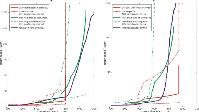
Figure 3: One-to-one relation between runout distance and return period derived from Schläppy et al. (submitted). Empirical relations and associated 95% confidence intervals derived from historical archives and tree-ring based reconstructions are compared to the ones derived from the
statistical-dynamical simulations. 1 ^ ^ ^
1
stop T x stopf T
x
F
f T
(7) where 1 ^ stop xF
is the inverse cumulative distribution function of the considered runout sample. For the different samples,1 ^
stop
x
F
was evaluated by kernel smoothing of the empirical inverse step function. This has the advantage to avoid using Hazen (Eq. 6) or other similar approximations, and provides smoother runout distance–return period relations as compared to the direct use of Eq. 6.Based on mean event frequencies ^
f
and estimated cumulative distribution functions^
(
stop)
F x
, return periods corresponding to all tree-ring based events were then evaluated using Eq. 6. At Château Jouan, runout distances derived from dendrogeomorphic data corresponded rather to large extent events with return periods >300 yr (Tmax=311 yr).Conversely, less information was obtained for small events, since the minimum return period that could be derived from the tree-ring record
was >10 yr (Tmin=12 yr). At Avalanche des
Pylônes, dendrogeomorphic records informed about return periods trespassing 100 yr (Tmax=118 yr).
3.3 Cross validation of model’s simulations with independent dendrogeomorphic data
Runout distances of extreme events have often been evaluated using physically based numerical models in the past. The rationales of Salm et al. (1990) where thereby used by practitioners to reliably evaluate “high magnitude” runout distances, but the data has not typically been derived from an explicit statistical framework (Ancey et al., 2004). More recently, statistical-dynamical modeling approaches have been put forward as an alternative approach, where calibration is based on local data reported in historical archives and where modeling will enable local predetermination of return period at any point along a given path (Eckert et al., 2007, 2008).
In this study, a statistical-dynamical approach has been used to analyze runout distances at two avalanche sites in the French Alps, Château Jouan and Avalanche des Pylônes. According to historical data available, the model (Eckert et al., 2010) was well capable to simulate current events with relatively small return periods (i.e. ≤30-yr return interval). As (ISSW 2013), Grenoble Chamonix-Mont-Blanc, France, October 7-11, 2013. pp. 672-678
validation of simulated data could not be realized for higher return periods with historical data, we reconstructed runout distances of larger, and less frequent, avalanches in both paths with dendrogeomorphic techniques. We then compared runout distance–return period relations as derived with the model simulations and tree-ring based data using the inverse cumulative distribution function (cdf) of the considered runout sample (Eq. 7). Analysis included the mean and mean square errors for both paths and different return period ranges, according to data availability (Schläppy et al., submitted).
In the Château Jouan path, such a comparison was possible for return periods ranging roughly from 10 to 300 yr, corresponding to the classical interval used in hazard zoning (Fig. 3). Mean and mean square errors amounted to 19.7 and 28.9 m, respectively, which can be considered very satisfying considering the different uncertainty sources that exist in this kind of analysis regarding data or model and with respect to the context of avalanche zoning problems.
In the Avalanche des Pylônes path, comparison was mostly limited to return periods ranging from 10–100 yr, given the empirical
Tmax=118 yr (Fig. 3). However, for the purpose
of comparison, we also calculated mean and mean square errors over the same intervals as in the Château Jouan path. Mean and mean square errors for the 10–300-yr return period intervals amounted to 23.5 and 45.8 m, respectively. Errors start to decrease with increasing ranges of return periods: for the interval 30–100 yr, errors are 17.1 and 36.1 m, respectively.
4. SYNTHESIS AND CONCLUSIONS
Specification of expected runout distances and related return periods are the first and most important steps for zoning in snow avalanche prone terrain Here, we presented an alternative semi-quantitative approach for the identification of past snow avalanche events, which integrally relies on the analytical skills of the dendrogeomorphic expert. This approach allows identification of different types of avalanche independently from their size. Using a Classification and regression tree (CART) approach, we demonstrated consistency and replicability of the procedure statistically. This proves that no bias was introduced by the expert during assessment. Furthermore, considering the good results from the CART approach, we successfully showed that the semi-quantitative approach is replicable elsewhere.
In addition, despite the various possible sources of uncertainty, this study provided for the first time, a cross-validation of runout distance–return period relations derived from a statistical-dynamical model with data derived from independent, natural archives. Hence, we are convinced that dendrogeomorphic data can be seen as an extremely valuable data pool for the assessment of runout distances and return periods of extreme avalanche events, and in particular for the hazard zoning on forested paths with limited or no historical data.
ACKNOWLEDGEMENTS
The studies presented have been realized within the framework of the MOPERA (MOdélisation Probabiliste pour l’Evaluation du Risque d’Avalanche) program funded by the French National Research Agency (ANR-09-RISK-007-01). R.S. acknowledges support from the Swiss National Science Foundation (project P1SKP2_148492).
REFERENCES
Alestalo, J., 1971. Dendrochronological interpretation of geomorphic processes. Fennia 105, 1–139.
Ancey, C., Gervasoni, C., Meunier, M., 2004. Computing extreme avalanches. Cold Regions Science and Technology 39, 161– 180.
Bartelt, P., Stöckli, V., 2001. The influence of tree and branch fracture, overturning and debris entrainment on snow avalanche flow. Annals of Glaciology 32, 209–216. Bebi, P., Kulakowski, D., Rixen, C., 2009. Snow
avalanche disturbances in forest ecosystems—State of research and implications for management. Forest Ecology and Management 257, 1883– 1892.
Breiman, L., Friedman, J., Olshen, R., Stone, C., 1984. Classification and regression trees. Wadsworth & Brooks.
Butler, D.R., Sawyer, C.F., 2008. Dendrogeomorphology and high-magnitude snow avalanches: A review and case study. Natural Hazards and Earth System Science 8, 303–309.
Casteller, A., Christen, M., Villalba, R., Martínez, H., Stöckli, V., Leiva, J.C., Bartelt, P., 2008. Validating numerical simulations of snow avalanches using dendrochronology: The Cerro Ventana event in Northern Patagonia, Argentina. Natural Hazards and Earth System Science 8, 433–443.
Corona, C., Lopez Saez, J., Stoffel, M., Bonnefoy, M., Richard, D., Astrade, L.,
Berger, F., 2012. How much of the real avalanche activity can be captured with tree rings? An evaluation of classic dendrogeomorphic approaches and comparison with historical archives. Cold Regions Science and Technology 74-75, 31–42.
Corona, C., Rovéra, G., Lopez Saez, J., Stoffel, M., Perfettini, P., 2010. Spatio-temporal reconstruction of snow avalanche activity using tree rings: Pierres Jean Jeanne avalanche talus, Massif de l’Oisans, France. CATENA 83, 107–118.
Dubé, S., Filion, L., Hétu, B., 2004. Tree-Ring Reconstruction of High-Magnitude Snow Avalanches in the Northern Gaspé Peninsula, Québec, Canada. Arctic, Antarctic, and Alpine Research 36, 555– 564.
Eckert, N., Naaim, M., Parent, E., 2010. Long-term avalanche hazard assessment with a Bayesian depth-averaged propagation model. Journal of Glaciology 56, 563–586. Eckert, N., Parent, E., Naaim, M., Richard, D.,
2008. Bayesian stochastic modelling for avalanche predetermination: From a general system framework to return period computations. Stochastic Environmental Research and Risk Assessment 22, 185– 206.
Eckert, N., Parent, E., Richard, D., 2007. Revisiting statistical–topographical methods for avalanche predetermination: Bayesian modelling for runout distance predictive distribution. Cold Regions Science and Technology 49, 88–107. Germain, D., Filion, L., Hétu, B., 2005. Snow
avalanche activity after fire and logging disturbances, northern Gaspé Peninsula, Quebec, Canada. Canadian Journal of Earth Sciences 42, 2103–2116.
Germain, D., Hétu, B., Filion, L., 2010. Tree-ring based reconstruction of past snow avalanche events and risk assessment in Northern Gaspé Peninsula (Québec, Canada), in: Stoffel, M., Bollschweiler, M., Butler, D.R., Luckman, B.H. (Eds.), Tree Rings and Natural Hazards. Springer Netherlands, Dordrecht, pp. 51–73.
Hazen, A., 1914. Storage to be provided in impounding reservoirs for municipal water supply. Transactions of the American Association of Civil Engineers 77.
Kohavi, R., 1995. A Study of Cross-Validation and Bootstrap for Accuracy Estimation and Model Selection.
Luckman, B.H., 2010. Dendrogeomorphology and snow avalanche research, in: Stoffel, M., Bollschweiler, M., Butler, D.R., Luckman, B.H. (Eds.), Tree Rings and
Natural Hazards. Springer Netherlands, Dordrecht, pp. 27–34.
McClung, D.M., Schaerer, P.A., 2006. The avalanche handbook, 3rd Revise. ed. The Mountaineers Books.
Pederson, G.T., Reardon, B.A., Caruso, C.J., Fagre, D.B., 2006. High resolution tree-ring based spatial reconstructions of snow avalanche activity in glacier national park, Montana, USA, in: Proceedings of the International Snow Science Workshop ISSW. Telluride, CO, pp. 436–443.
Reardon, B.A., Pederson, G.T., Caruso, C.J., Fagre, D.B., 2008. Spatial reconstructions and comparisons of historic snow avalanche frequency and extent using tree rings in Glacier National Park, Montana, U.S.A. Arctic, Antarctic, and Alpine Research 40, 148–160.
Ripley, B.D., 1996. Pattern recognition and neural networks. Cambridge University Press.
Salm, B.W., Burkhard, A., Gubler, H.U., 1990. Berechnungen von Fliesslawinen: Eine Anleitung für Praktiker mit Beispielen. Schläppy, R., Eckert, N., Jomelli, V., Stoffel, M.,
Grancher, D., Brunstein, D., Deschatres, M., Naaim, M., submitted. Validation of extreme snow avalanches and related return periods derived from a statistical-dynamical model using tree-ring based techniques. Cold Regions Science and Technology.
Schläppy, R., Jomelli, V., Grancher, D., Stoffel, M., Corona, C., Brunstein, D., Eckert, N., Deschatres, M., 2013. A new tree-ring based, semi-quantitative approach for the determination of snow avalanche events: Use of classification trees for validation. Arctic, Antarctic, and Alpine Research, 45(3), 1-13.
Stoffel, M., Bollschweiler, M., 2008. Tree-ring analysis in natural hazards research – an overview. Natural Hazards and Earth System Science 8, 187–202.
Stoffel, M., Bollschweiler, M., Butler, D.R., Luckman, B.H., 2010. Tree Rings and Natural Hazards. Springer Netherlands, Dordrecht.
Stoffel, M., Bollschweiler, M., Hassler, G., 2006. Differentiating past events on a cone influenced by debris-flow and snow avalanche activity – a dendrogeomorphological approach. Earth Surface Processes and Landforms 31, 1424–1437.
Stoffel, M., Butler, D.R., Corona, C., 2013. Mass movements and tree rings: A guide to dendrogeomorphic field sampling and dating. Geomorphology in press.