DISTURBING ECOLOGIES Interventions in Boston's Seaport District by Christine Cerqueira Gaspar
A.B., Environmental Studies, Brown University, 1996
Submitted to the Department of Architecture and the Department of Urban Studies & Planning
in Partial Fulfillment of the Requirements for the Degrees of
MASTER OF ARCHITECTURE and MASTER OF CITY PLANNING at the Massachusetts Institute of Technology, June 2004
(c) 2004 Christine Cerqueira Gaspar. All rights reserved. The author hereby grants to MIT permission to reproduce and to distribute publicly paper and electronic copies of this thesis document in whole or in part.
Signature of Author
Certified by
Certified by
Accepted by
Accepted
Department of Architecture ardirban Studies & Planning, May 19, 2004
'V J. Meejin Yoon
Ass anfrofessor, Department of Architecture, Thesis Supervisor
, , l , , ese
Gregory Morrow
cturer, Department of Urban Studies & Planning, Thesis Supervisor
William Hubbard, Jr.
Adjunct Associate Professor, Department of Architecture
Dennis Frenchman Professor of Practice of Urban Design, Department of Urban Studies & Planning
MASSACHUSETTS INSTITUTE OF TECHNOLOGY
AUG
R3ES
-
LIBRARIES
ROTCH
hv-Interventions in Boston's Seaport District by Christine Cerqueira Gaspar
A.B., Environmental Studies, Brown University, 1996
Submitted to the Department of Architecture and the Department of Urban Studies & Planning
in Partial Fulfillment of the Requirements for the Degrees of
MASTER OF ARCHITECTURE and MASTER OF CITY PLANNING at the Massachusetts Institute of Technology, June 2004
ABSTRACT For the past fifty years the question of nature has been conspicuously absent from urbanistic discourse... The development of the
American city can be explained through the opposition between nature and culture, wilderness and city. - Diana Agrest, 1996 From the Greek for study of the house, ecology refers to the relationships (or the study thereof) between organisms and their physical environment. As a field of study, ecology is relatively young, one that initially concentrated on descriptive research attempting to understand the processes of "natural" systems absent human intervention. Only recently have ecologists begun to argue for the understanding of the urban environment as participating in these processes. At issue in this debate
is how one perceives the role of humans. The historical Western division between "nature" and "culture" is still operative;
for many, the very definition of nature is that which is non-human.
This thesis is an attempt to move beyond that division by forging an understanding of the city as a set of interlaced ecologies, including the biotic (animal, plants, microorganisms), the abiotic (water, wind, sun, soil), the sociocultural (social networks, psychogeography), the political (land uses, wards, school districts), and the economic (land value, capital flows), among others. Through an understanding that places humans and human settlement directly in nature, a new mode of urban intervention may becomes viable. The goal of this thesis is to explore and develop new models for understanding the ecological city, models that will enable new modes of urban intervention.
ARCHITECTURE THESIS ADVISOR: J. MEEJIN YOON
TITLE: Assistant Professor of Architecture
CITY PLANNING THESIS ADVISOR: GREGORY MORROW
TITLE: Lecturer in Urban Studies and Planning
READER: ANNA DYSON
DISTURBING ECOLOGIES Interventions in Boston's Seaport District by Christine Cerqueira Gaspar
This thesis exists thanks to the support and encouragement of many AC K N OWL E D G E M E N TS people, to whom I am exceptionally grateful.
To my advisors, Meejin and Greg, thank you for taking this risk
on and with me, and for supporting me throughout (despite my insistence on playing with yarn). To my reader, Anna Dyson, for your insights and support.
To Eran Ben-Joseph and Dennis Frenchman for continued support
throughout my (many) years at MIT.
To Mom, Dad, and Lucy, for love and support always.
To Aliki, Tracy, and James. I'm positive I wouldn't be standing here
today if you hadn't kept me believing I could make it.
To Andrew, for so much fortitude. I know this work couldn't exist
without you, and I would be a much lesser person for not having studied architecture with you.
To Aisling, Sabrina, Marlene, Alex, and James Tichenor, for keeping
me going. But mostly for making me laugh until I forgot I didn't have a thesis.
To Kyle, this thesis definitely wouldn't be what it is without my
string-obsessed twin. Thank you for repeatedly tricking me into thinking I could pull this off.
TABLE OF CONTENTS
09 INTRODUCTION
11 A CITY OF ECOLOGIES
15 BOSTON'S SEAPORT DISTRICT
19 AN ALTERNATIVE APPROACH 23 FOUR MODELS 25 MODEL 01 33 MODEL 02 37 MODEL 03 41 MODEL 04 49 ENDNOTES 51 BIBLIOGRAPHY
For the past fifty years the question of nature has been conspicuously absent from urbanistic discourse... The development of the American city can be explained through the opposition between nature and culture, wilderness and city. - Diana Agrest, 1996
INTRODUCTION In The Machine in the Garden, Leo Marx describes the history of American urbanism as the struggle between the idealized, purifying "nature" of the untamed landscape and the refined, civilizing "culture" of the city. The debate is still open, but what remains largely undisputed is the separation of these realms. The city is artificial and it is here; "nature" is pure, unobstructed, and out there. This dialectic may be a artistically productive, but the urbanistic ramifications are troubling. The view of the city as an imposition on and disruption of nature prevents us from understanding and embracing the processes of life that are integral to the urban ecosystem.
This thesis is an attempt to move beyond that division by forging an understanding of the city as a set of interlaced ecologies, including the biotic (animal, plants, microorganisms), the abiotic (water, wind, sun, soil), the sociocultural (social networks, psychogeography), the political (land uses, wards, school districts), and the economic (land value, capital flows), among others. Through an understanding that places humans and human settlement directly in nature, a new mode of urban intervention may becomes viable. If how we percieve the world establishes the framework for acting wthin
it, then the models we generate are critical to how we intervene in the city. The goal of this thesis is to explore and develop
A CITY OF ECOLOGIES From the Greek for study of the house, ecology refers to the relationships (or the study thereof) between organisms and their physical environments.' As a field of study, it may be defined as the effort to "forge a holistic understanding of the natural processes that take place within a defined system."2 While it is commonly used to refer to the non-urban environment,
ecology does not discriminate between "urban" and "wild"; every living system participates in some set of processes. "The central idea is that a patch of the planet, a natural community, contains discrete living (biotic) and nonliving (abiotic) elements that interact in synergistic ways. These elements include the living organisms, the landscape patches, the parent geologic materials underlying the soils, and the local hydrologic and weather patterns."3
Ecology is a relatively young field of study, one that initially concentrated on descriptive research attempting to understand the processes of "natural" systems absent human intervention. Only recently have ecologists begun to argue for the understanding of the urban environment as participating in these processes.4 At issue in this debate is how one perceives
the role of humans. The historical Western division between "nature" and "culture" is still operative; for many, the very definition of nature is that which is non-human. However, as the scale of human impact on the planet has increased, even unpopulated biomes are affected by our behavior, making the human/nature distinction almost impossible to delineate. One of the most troubling aspects of the intellectual separation of human from non-human ecological processes is the resulting attitude about environmental quality and responsibility. Historian Matthew Gandy argues that this dichotomy leads to the entrenched belief that we must look outside of society and culture "for the ecological template for urban change," thus ensuring our failure to achieve any significant results.' Ecologists have tended to view the urban environment as a degraded version of "natural" conditions, while urban planners tend to focus on urban "nature" as trees, parks, and, on occasion, surface water. Urban ecology potentially provides a way to understand human behaviors within the context of the planet's other ecosystems.
The relationships between living organisms and their environments (given and formed), ecologies suggest a way to understand the city less as a product of human creation and more as a complex set of forces (biotic and abiotic) negotiating
a shared existence. As perceived in this thesis, topographical conditions, the cultural landscape, and political boundaries
represent actual experienced conditions that shape and are shaped by the processes of life that occur in the city, and therefore all constitute roles in human ecologies. Ecology as a lens may offer a way to move beyond the culture/nature city/ wilderness dichotomies that are so deeply embedded in our cultures and in our landscape practices. This understanding of ecology requires a situating of humans in nature and an analysis of constructed environments within this context. To the extent that these ideas inform the design of the built environment, they may bring to cities a set of experiences that depart from the trajectory of landscape design descended from romantic traditions.
This position within architecture and urbanism is strongly influenced by two strains of thought in the science and design
-disciplines: on the one hand, the development of urban ecology, and on the other, landscape urbanism.
URBAN ECOLOGY
In its short history, ecology as a field of study has focused on analyzing relationships between organisms, processes, and
the physical environments that they negotiate, in the absence of human intervention. In the last five years, some ecologists have begun to argue that such a notion is unrealistic in the contemporary world, and that models that include humans must be developed. Even more recently, a body of thought has emerged arguing that the urban environment must be considered
in the same light, and that urban processes and landscapes must be understood as equally active and productive, and
as a "legitimate" urban ecosystem.6 They argue for "the concept of the natural city, a human city functioning as a an ecosystem on the scale of an estuary or a rain forest" to replace the view of the cities as "foreign impositions upon the native landscape."7 They point to the many constructs in our society that reinforce the view of a detached, artificial, and ecologically unproductive city. For example, (as Anne Sprin has pointed out), the absurdity of the U.S. Soil Survey's classification system, in which the painstakingly detailed mappings given way at every city limit to a homogeneous categorization of the soil as "urban," as if all life ended at the metropolitan boundary.
This view precludes the possibility of an ecologically active city. Yet the counterargument emerges:
"Urban biodiversity exists at a crucial nexus of ecological and societal interactions, linking local, regional and global scales....
While more traditional notions hold that the environments of cities are static and that once intensive development has taken place, (e.g. urbanization), ecological functions and properties disappear, continual change in both the natural and the built environments characterizes even the most urbanized sites. Urban ecologies are projected to become even more dynamic in the
future, particularly as a result of global climate change."8
The National Science Foundation, recognizing this view, is funding research in Baltimore and Phoenix as part of the larger Long Term Ecological Research Network, in which 24 international sites are studied by 1,1000 scientists. The inclusion of two metropolitan areas in this research program, which was founded in the 1980s, is a major milestone for this emerging field. The expansion of ecology to the urban environment and, more significantly, the conscious acknowledgement and acceptance of the human in ecology are critical to the ideas explored in this thesis.
LANDSCAPE URBANISM
Just as the notion of urban ecology is only now gaining ground in the sciences, a parallel movement in the design fields
is emerging. Ecological models have influenced the fields that deal with the design of the built environment, notably in
the work of Ian McHarg and his students. Since the 1 980s, the methodologies, vocabulary, and ideas of field ecology (the study of living populations in their native contexts) have been increasingly integrated into landscape architecture, in turn leading to current practices of "landscape urbanism," in which the landscape is used as "a representational lens to describe the contemporary city."9 Landscape urbanism, according to Charles Waldheim in his genealogy of the discipline, is "the use of landscape in the stitching of infrastructure into urban fabrics," and "advocates the conflation, integration, and fluid exchange of environmental and infrastructural systems."" What is compelling about these practices is that, at their best, they are willing to transcend the historical nature-culture dichotomy to both understand "nature" as a constructed entity
(physically and psychologically), and to see the city as a product of "nature" as well as of culture.
The major projects of landscape urbanism thus far seem to be unified by 1) the conscious union of "nature" and "culture," through the productive interplay of cultural, infrastructural, and programmatic components with plant life, soil matter, and biophysical processes; 2) the generation of urban landscape forms, processes, and experiences that address themselves to contemporary needs and discard the formal, romantic constructs of the "urban nature" of the past; and 3) the introduction of indeterminacy, succession, and the aleatory both in an effort to avoid top-down design and no doubt in reflection of a contemporary scientific cosmology in which Einstein and Heisenberg have replaced Newton, the clockwork order giving way to a stochastic one.
The competition entries for Toronto's Downveiw Park and New York's Fresh Kills Landfill, as well as the work of West
8, have emerged as the seminal projects of this landscape urbanist approach. The competition entries rely strongly on
ecological ideas of habitats and succession plantings; all unify infrastructure with living matter and emphasize process, either within the design or in the temporal unfolding of the project. In their performativeness, these projects engender a critical component of nature that historical constructions neglect, finally transcending the compositional design of city and park in exchange for a dynamically unfolding choreography between structures (roads, fields, etc), plantings, users, and abiotic site conditions."
In contrast to the increasingly homogenous products of traditional urban design, landscape urbanism weaves "natural
ecologies with the social, cultural, infrastructural layers of the contemporary city," creating an urban environment that is responsive to the unique set of local conditions (and their interplay), through a layering of localized information, rather than a rigid erasure of local variations with a formally composed plan." "Layered, non-hierarchical, flexible, and strategic," this is a post-modern view of the city that focuses on process and indeterminacy as critical, desirable conditions of urbanism." For example, succession plantings play a key role in several projects (Stan Allen's work, for example). In others, the landscape functions as both a garden and a machine that cleanses water (Julie Bargmann's work). Still others layer in different pieces of program over time, as the site adjusts, delaying the achievement of a climax state well into the future (several Downsview entries). In another example, Dutch designers West 8 created "a general botanical strategy of sunflowers, clover, and beehives" at Schiphol Airport in order to "respond to Schiphol's programmatic and political futures; landscape is conceived as a strategic partner in the complex process of airport planning rather than (as is usually the case) simply an unfortunate victim of it."" A further factor spurring the growth of this discipline is, as Kenneth Frampton has speculated, the possibility that the limitations of private ownership, land speculation, and the decentralized condition of the modern (particularly North American) city make landscape the most viable (and relevant) place to address urban design.'
The limitation of these projects, however, is that they engage ecology in a largely metaphorical way. And they are still only parks, not methods of engaging the urban fabric of cities. No doubt more projects will address themselves to these issues, as the first proposals are realized on the ground. The focus of this thesis, in a way, is the bridging of the emergent fields of urban ecology and landscape urbanism. Between science and architecture is a zone in which new models for visualizing the city may emerge. In this thesis, that visualization is focused on Boston's Seaport District.
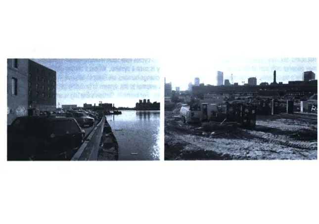
FIGURES 1-3. Boston Harbor and the Seaport FIGURE 4. Filling in of mudflats over time
BOSTON'S SEAPORT DISTRICT Transportation infrastructure and social networks, aside, there are urban environments where it is, difficult to conceive of ecologies existing and influencing one another. And there are some environments rife for the landscape ecology lens. Boston's Seaport District is one of those. (See Figure 1-3.) The area was incrementally constructed on former mudflats between 1804 and the mid-twentieth century. Stretching East and North from South Boston (First Street roughly indicates the location of the pre-fill shoreline) towards the Financial District and into the Boston Harbor, the area comprises Fort Point, several piers (Fan, Fish, Four, Commonwealth, and Subaru), a former naval yard (now marine industrial park), the Gillette campus, and a new convention center cluster including the World Trade Center, two hotels, and the new Vinoly conference facility. In between are zones of indeterminacy that make the district very difficult to image as a whole. Largely composed of parking lots and other low-intensity land uses, these areas imply the aftermath of some industrial heyday. In fact, most of the land area in the Seaport has never reached its "optimal" use (as defined by the various plans proposed for
it over time). With the notable exceptions of the Fort Point warehouse area, the Gillette headquarters, and the local industrial
zone near First Street, the Seaport's history is one of constant and repeated failure.
The fundamental questions of this thesis could be addressed in virtually any urban site; the reason to address them here
is that the negotiation of human, social, urban ecology with the physical, environmental ecology of the mudflats, harbor,
and their attendant weather patterns has always been so visible and so integral to the character of the place. Its urban morphologies developed over time, but most can be traced to a handful of moments in which bold ideas about the area's growth spurred expansion. Further, the current spurt of development in the area introduces a set of urban design practices intended to at last colonize this area for safe urban living. A strong tone of the current plans is the "normalization" of this area through urban design guidelines. While these plans, as the many that have preceded them, seem as likely to succeed as not, the development context presents an opportunity to incorporate a set of ideas about urban ecology into the future of the site. The work investigated here is a resistance to homogenous urban design, but perhaps it may also enrich current urban design practice.
PLANNING AND DEVELOPMENT IN THE SEAPORT TODAY
In the past two decades, the seaport's expanses of land became desirable for their ability to host the contemporary urban
functions that are so difficult to site in older cities - convention centers and stadiums, for example. In a way, the siting of these uses is deeply consistent with the area's past, the large infrastructures meant to support an idealized urban future
- the 20*h century stadium replacing the 18th century wharf. Today's planning and development documents, in fact, ring
strikingly close to the tone of documents dating back to the 19th century, extolling the virtues of the new land in relieving the congestion of the city's booming population by providing new commercial space." In a way, South Boston has always
been the urban frontier. The continual promise of new land, deeper harbor, bigger piers, repeatedly led to the expansions, the realization of a manifest destiny to fill out to the edge of the mud flats, a plan developed in the early nineteenth and realized only in the mid-twentieth century. Little social, environmental, or economic good seemed to result from these moves, however, at least when they were intended to. The area's major projects were all failures in their times, and the sea of parking lots, barely rising above the ground like the swamp grasses before them, is the contemporary testament to those failed visions.
Though numerous plans have been issued since the 1980s, the area remains largely undeveloped (subject to endless court battles and controversies, not unlike the fill projects of its early days). The vision for the harbor area has been hotly contested (with the large McCourt property at Pier 4 changing hands again in December 2003), but the city's plans for the larger area continue to hinge on the convention trade, with the enormous new conference facility at its heart. Little effort is being made to address the existing fabrics of the area, beyond a set of urban design guidelines proposing nautical-themed street lamps for the entire Seaport. If all the existing proposals are built out, the area will go from 14 million square feet of development to almost 30 million."
AN ALTERNATIVE APPROACH
THE ECOLOGIES
"The idea of "urban acupuncture" advanced as an operative metaphor by the Catalan urban designer Manuel de Sola Morales may also be assumed as a general analogue for what is operatively possible at a given moment or moments in time, either as a relatively limited,
single intervention in terms of built fabric in the conventional sense or as a modification of say a transportation infrastructure or of an ecosystem that may in its turn entail modifying aspect of a watershed or rectifying current patterns of waste disposal or even the recovery of brownfield sites of varying size and configuration through...forms of landscape intervention."" Kenneth Frampton, 2002
The intention of the models developed in this thesis is to create a framework for intervention in the Seaport by expanding our understanding of the interaction between the various ecologies of the site. As suggested, this is a proposal for an alternative approach to structuring the future of the Seaport District. Rather than focusing on boulevards and thematic lighting to unify the very disparate areas of the Fort Point Channel, South Boston, and the industrial waterfront, this proposal establishes a framework for a "weak" structure of small, local insertions that interact directly with the network of ecologies. It is "weak" because it deals more with "physical and perceptual frameworks" by "highlighting protocols of activity and exchange within an environment," than with physical restructuring of the site."
It is an effort to understand the Seaport not as an acreage or number of vacant parcels but rather as a landscape, a
constructed and responsive landscape that is part of multiple ecologies: biological, social, cultural, abiotic, infrastructural, economic, etc. It is an effort to create the groundwork for acting upon the landscape, not through compositional or cosmetic interventions, but through strategic, tactical ones that begin to proffer an idea of a public realm that is not superimposed
rigidly upon the site but that is related to and grows forth from the landscape we find there today, on that includes traces of
its past and of many possible futures.
The starting point in this project is the grounding in the general site's ecologies. Thus, the methodology begins with the defining, listing, and analyzing of those ecologies. At issue is the interaction between the ecologies, the way they interface with one another and, as a result, respond to each other.
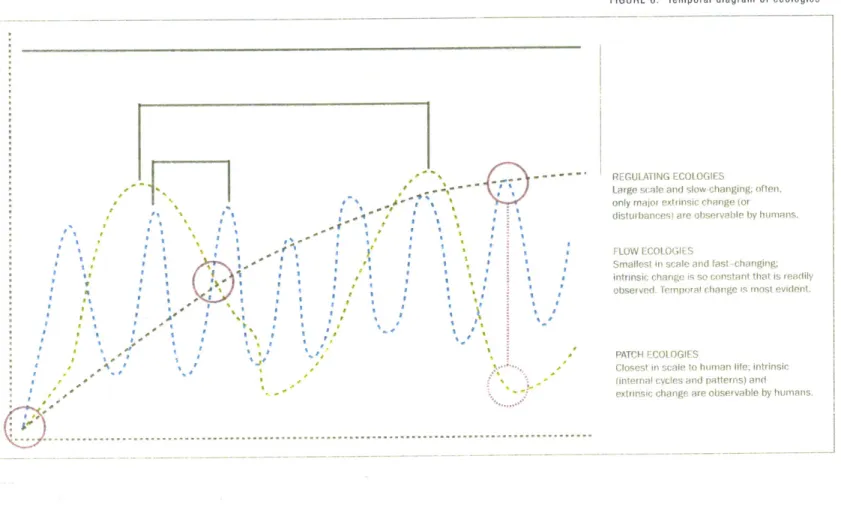
While the list is not exhaustive, I identified several ecologies, which I then attempted to categorize by shared characteristics. Initially it seemed that geographical scale and spread were the organizing factors, but it became clear that all of the ecologies operate, essentially, as flows in both space and time. On further analysis, temporal scale emerges as the more meaningful distinction between the categories. Figure 6 represents a temporal mapping of the three ecological systems: regulating systems, patches, and flows. The distinguishing characteristic is the rate at which this flow occurs relative to
human perception.
-FIGURE 6. Temporal diagram of ecologies I a I a I a Il a a 'I a a r I Ioil~ l.a a a' a a ' I a a a I a a a .3 a ~ a ~ a * I aI~ , a ~ a ..4~ I a a ~ a a I U ~
:
; a 11 I REGULATING ECOLOGIESLarge scale and slow changing: often. only major extrinsic change (or
distur bawes) are observable by humans.
FLOW ECOLOGIES
Smallest in sca 'le and fast crhanging;
intrinsic changle is o onstant thlat is readily observed, Tojwral change is most evident
PATCH ECOt OGIES
Closest in scale to hioian life: intrinsic
(internal cycles and patterns) and extrinsic change are observable by humans.
This perspective is a critical aspect of ecology, in which scale is a constant issue. In ecology, one sets the scale for a research project relative to the process or population being researched. In addition, some attention is also paid to the scale immediately above and below the focus scale, in order to understand factors that affect behavior at the relevant scale. In this case, the focus on introducing humans into an ecological approach requires that this be the frame of reference. The three scales of ecologies identified are regulating ecologies, patch ecologies, and flow ecologies. Regulating systems
are not static, but may appear so to humans because their process cycles may span multiple human lifetimes. As a result, we may observe only part of the cycle. For example, topography is such a system. Within a human lifetime, the change in
a given site's topography may be marginal. In fact, most of the change humans are likely to observe in a regulating system
will be extrinsic changes, or changes that are caused by factors external to the system in question (as opposed to intrinsic
changes, which represent the regular fluctuations within a system). For example, Boston's Big Dig is an enormous extrinsic change to the city's topography.
Patch ecologies are closest to the scale of human life, and may reveal both extrinsic and intrinsic change over time. These systems include things like changes in urban settlement patterns, land use changes, animal population shifts, shoreline
erosion and deposition, and riverbed realignment.
Flows exhibit the shortest cycles and, because of their constant fluctuation, may appear to humans as flows in which intrinsic changes are so constant that we hardly notice extrinsic change. Examples include traffic flows, tides, and diurnal patterns such as sunrise/sunset.
FIGURE 7. Fort Point Channel site
FIGURE 8. Ecology interaction diagram
Human Activity Land Use --- (ParkinIndutr~I a Psycho p(Fideve primiit y Infrastructure
Road,. Sewaqe. Sa wall)
geography
opment plan s
tdow~ntwn)
FconomicValue /
F0 U R M 0 D E L S We do not simply 'see' things; we 'see' things as something. There is a covert process of interpretation implicit within the process of observation. We observe nature through a filter, a set of assumptions, which conditions what we thing we are seeing.?
- Alister McGrath
If the map often becomes the master plan, then the mapping itself is enormously meaningful in constructing worldview and is itself an intervention. This phase of the research consisted of creating digital and three-dimensional models exploring
the various ecologies and their relationships to one another. Factors discussed above were given dimensional meaning here, as X, Y, and Z axes took on values for intensity, duration/rate of change, and interdependence. Through the different modes of operation, or of registering change, both internal and external to a given system of representation, the models suggest different modes of intervention.
This basic framework is used to develop four ecological models of the city. All four address active ecologies of the Seaport, though each one has a particular focus. As such, each has its strengths and weaknesses as a model. The multiplicity is viewed as a strength here - both because it may lead to more diverse readings of the site and because it reminds us that complex systems neither can nor should be reduced to a singular mode of representation.
For this research, a site on the Fort Point Channel was chosen, and five ecologies selected for further study. (See Figures 7 and 8) Those ecologies are psychogeography, infrastructure, human activity, land use, and economic flow. The five were chosen because they are subtly linked, and yet each has a strong underlying presence in the site. The specific selection could have been anything; this site and these ecologies merely offer the opportunity to explore more concrete conditions
MOD EL 01 Figure 6 represents ecologies as functions of time. In developing the first model, however, the ecologies are interpreted
spatially. As Stan Allen points out in his development of the idea of a "thick 2D," "The natural ecology of a meadow, field, or forest exhibits horizontal extension in the macro scale, but at the micro scale it forms a dense mat, a compact and highly differentiated section.21 Here, as well, the macro mapping addresses itself to that horizontal extension in a planimetric,
spatial mapping.
The goal of this mapping is not geographical and informational precision. Instead, the focus is to understand the relationships between different ecologies in terms of their concentrations of activity on the site, particularly relative to the idea of overlaps between systems. In ecology, zones of this type of complexity are often the richest zones in terms of activity, diversity, and
productivity. Productivity, which in urban planning tends to refer to the optimization of land use relative to a set of values
(which may include economic benefit, engineered efficiency, pedestrian activity, cultural value, and social justice, among others), in ecology refers to the level of biotic output (or activity) per unit of input. Shifting definitions of productivity are
visible in urban form. For example, in the seaport district, the optimal use of the site has ranged from vessel for residential
growth (early 19th century), deep water port (19th and 20h centuries), industrial and military zone (mid 20th century), to the current climate of interest in high-rise office/residential and conference facilities.
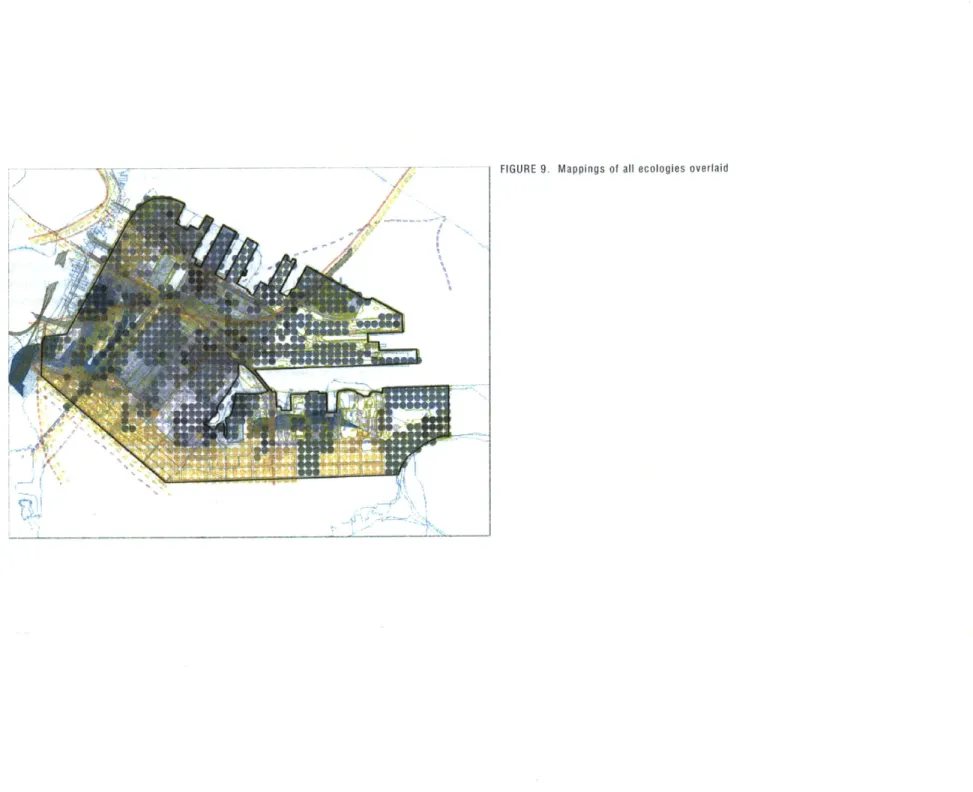
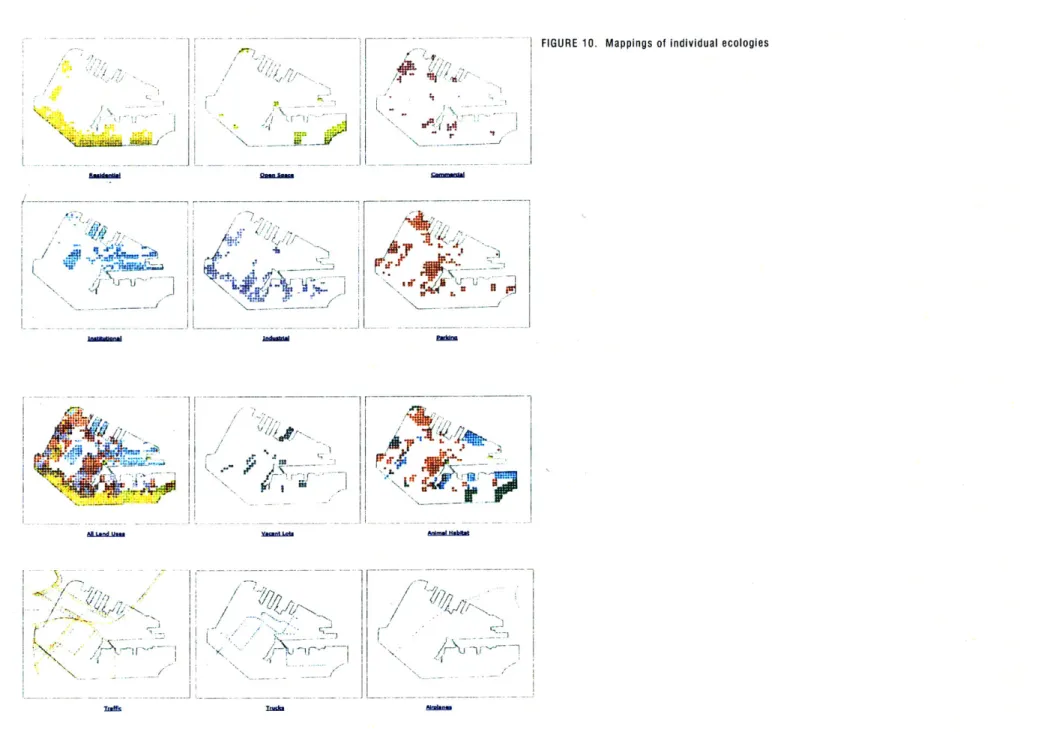
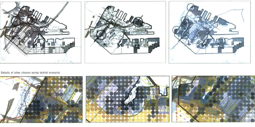
The information that is mapped, as well as the manner in which one may collate it, then, is critical to how "productivity" is defined and projected back on to the city. The maps created are presented in Figures 9 and 10. In addition, the maps were overlaid in an interactive, web-based format, in which users can toggle each layer on or off, to analyze the data in different configurations. These configurations represent different value systems and result in the identification of different nodes of activity. Figure 11 represent a subset of possible mappings.
Having identified a set of criteria to investigate in this research, this mapping becomes a way to build up those layers to identify points of intensity, with potential for intervention. Different points of intensity emerge depending on which layers are turned on or off. An ecology scenario, a development scenario, and an intermediate scenario are investigated; the intermediate scenario yields three sites, one of which is further explored here. In this case, the mapping in Figures 9 and 11 shows six nodes of activity. Of those, three are chosen for further investigation. (The remaining three are eliminated based on the inaccessibility of two of the sites and the recent completion of development on another.) The sites are located 1. at the base of the Reserved Channel, 2. at the juncture of Second Street and Haul Road, and 3. along the Fort Point Channel,
behind Melcher Street.
The mode of intervention suggested here is one of adding surfaces to the system. By introducing another "ecology" or a foreign process, the existing system is weighed down in locations of intervention. (See Figure 12.) While this model is a
/
~./* L
ik
Fl;
-a,
FIGURE 10. Mappings of individual ecologies
/ Ar A N, / ~;'2() / / 4Y/j,;, ~NN~ I.-7 ~* <')j' 'I-,'' ~r+1 ~I ~ - I Isril a, r / /1'~ / ,i~{r'& / -J -- I ~pJu Ai~ Ir r-i An Th~ I. Rum"
I If INY, 94
/
I
SMfE,,W~tL, I~nbx F10 C - ouseful step in identifying, locating, and overlaying ecologies, its flatness is a limitation. The mapping presents only binary conditions; either an ecology exists at a particular location or it doesn't. The temporal dimension is missing, as is any depth in how one understands relationships between ecologies.
The strengths of this map are that the activity and the thickness of the layers are evident. The greatest weakness is that lack of a temporal datum in the model, as well as a lack of penetration between the layers. The patch conditions are most easily represented here, while the faster flows and the more spatially spread regulating systems are less clear. Even so, these maps provided the basis for the later systems developed here.
The mode of intervention suggested here is one of adding surfaces to the system. By introducing another "ecology" or a foreign process, the existing system is weighed down in locations of intervention. (See diagrams) One can then imagine this intervention as dislocating other ecologies in space or perhaps reorganizing their relationships to each other (as shown in the diagram). One could also imagine that the layering that occurs at a given site builds up to support different types of surface activities (as suggested by Stan Allen's idea of the "thick 2D"). The dearth of information in this model regarding the interrelationships between ecologies makes it difficult to imagine how these actions might be translated into real conditions. The greatest strengths of this model lie in its ability to convey nodes of activity and, through the interactive mapping, to understand how privileging different value systems results in completely different mappings of the city.
FIGURE 11. Mappings through different lenses, planning scenario, ecology scenario, and hybrid scenario. Circles highlight points of intensity.
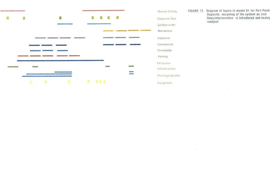
--.--- """"" ---... -... H uman Ac tivity Economic flow Surface water Residentoia Industrial Commeicial Permeable Parking Fill soure Ingfrstlrictre
FIGURE 12. Diagram of layers in model 01 for Fort Point Site
Opposite, morphing of the system as (red lines)interevention is introduced and ecologies readjust
- U I I- - Em,, -- - - -- a I I- - I HUE -- U U U - - ________ -- -- mm,.
-Relative
intensity
of
ecologies
Intensity
of
ecology
at
a
given
point
Water flow
Permeabi I ty
Psychogeography
Topography
The second model also begins at the scale of the Seaport. It is an attempt to introduce operational interrelationships between ecologies and an element of time. Five ecologies are mapped onto the site, with vertical rods representing the intensity of each ecology at a given point in the site (0 - 100%). Vertical rods introduce another datum, in one case intensity, in another, time (in terms of internal rate of change within an ecology). Another model translates the vertical measure to rate of change, yielding similar dependencies, but different morphology.
The strengths of the model are the interconnection between layers; one can see how ecologies take primacy in a given location, then are subsumed by the intensity of other systems. Unlike the initial mapping, this model presents the ecologies as not binary surface conditions, but as always present and either latent or active.
The physical model - the density of weave as well as the many rods - however, prevent significant physical interaction with the model. The interventions suggested are insertions, removals, or the further weaving of layers, all of which would alter the systems, but in ways that are perhaps more static.
Removel/ subtract transect Add nev weave or strand Insert to object displace I I i E A I
The intervention explored here is one of weaving an additional thread through the system. The new system then becomes
a feedback loop. For example, the loop might be dormant most of the time but be triggered by threshold conditions in one
of the ecologies that it is linked to.
In this model, one can imagine an intervention that is woven through not one site, but the larger district, emerging at
discrete points, or under particular conditions triggered by the activities of other ecologies. In this case, the new strand is
a secondary system, grafted on, that is activated by a threshold condition when a level of intensity in an existing ecology is attained. In this map, the pink thread is tied to waterflow, suggesting, for example, a set of plantings that bloom after a
0 0
a
0 O o o O b 0
This mapping is based more abstractly on the relationships between ecologies, rather than on a direct mapping in the site. (Another layer of this would have been to return it perhaps to the original, digital map created in this project.) In this case, the five ecologies are mapped based on their relative pull on each other, as well as on their relative resistances (which is,
in turn, based on the duration of change within a system).
This model focuses on the mechanisms of the primary and secondary relationships in the system of ecologies. Any change
in an ecology pulls at both the ecologies directly interacting with it and the ecologies that interact with those.
This map, in some ways, is the most robust of the models developed here, because of its ability to show both direct and indirect impacts of changes in an ecology on the other ecologies.
37 MODEL 03
The intervention explored here is one of pulling at the system to activate portions of it, as its effects ripple through the system. This effect could achieve a particular end; for example, by changing the land use of a site, one potentially alters not only economic value and human activity, but indirectly psychogeography. Additionally, one might even think of land use change as a product of changing infrastructure (as is clearly the driver for "disturbance" in suburban subdivisions).
One might also use this device to a revelatory end. For example, using the ecologies in model 2, one might adjust the permeability of a surface in order to adjust surface water flow. More extremely, one might contemplate intervening in the sewage overflow system in the Marine Reserve Site in a more radical way to make a revelatory statement.
Infrastructure Psychogeography Land Use Economic Flow Human Activity
/, V7
6
This model in a way is a hybrid between the flat layers of the first model and the intertwining of the later ones. The five layers are represented as planes, but they gain depth when stacked on each other and their points of contact joined, either through a gluing or binding of the points, or through introduction of a vertical axis that connects as it separates. The systems are free to move around each other but are bound closely to each other in places where such is the case on the site. (For example psychogeography and infrastructure.)
In this model, each ecology is a two-dimensional network. Patches are networks of varying densities, regulating ecologies
take on specific spatial nodes and hold points for attachment throughout. Flows take on points in spatial locations that coincide with their paths of movement or, in the case of economic flow, with unique values (in this case individual lots). As constructed here, this system contains no temporal element. However, it would be possible to introduce multiple layers for each ecology, or even to combine sets of temporal mappings of the ecologies in a similar format. It also allows for some weaving to occur, when the binding of ecologies requires it.
41 MODEL 04
= Ii
I
*' ph 1 -~-~ )I
~:
~III
H
I~
I
'i/
'I
I i'I
A
I fiI
- - --z -_ F"---. - - -- 7/'~~"" - -F- - /
I
/
I
//
//
/I
F-F -- -F -7/
--F--I
"N/
Opening/separatingBndg Bindinga - -- _____
The intervention suggested here is one of altering the manner in which the ecologies are bound to each other. The models suggest a pulling apart of the systems in order to highlight the ways in which they are more closely bound. Alternatively,
it opens up the possibility of approaching the city in terms of how to bind these systems to each other. For example, how
CONCLUSION
Although this thesis does not propose specific interventions for the Seaport, it is my hope that the
stud-ies contained within, and the models put forth, will stimulate discourse on the idea of the city as a set
of interlinked ecologies. I feel that, in the final review, this was achieved. This process revealed one of
the greatest challenges of undertaking this kind of effort: making decisions in the face of tremendous
complexity. I intentionally avoided computational models in this effort, in order to address directly how
one can obtain and convey a more visceral or internalized sense of how these systems interact, rather
than merely overwhelming the reader. I hope to continue the work presented here. And I hope that
others will find it useful in their own efforts to understand and intervene in the city.
E N D N OTE S 1 The Columbia Encyclopedia, Sixth Edition. Copyright © 2003 Columbia University Press. At http://www.bartleby.com/65/ec/ecology.html, accessed
on December 10, 2003. Defines ecology as "study of the relationships of organisms to their physical environment and to one another."
2 Lord, Charles P, Eric Strauss, and Aaron Toffler. "Natural Cities: Urban Ecology and the Restoration of Urban Ecosystems," in Virginia Environmental
Law Journal. 21 Va. Envtl. L.J. 317. 2003 p. 1
3 lbid.
I See Lord, et al. "The concept of the natural city, a human city functioning as an ecosystem on the scale of an estuary or a rainforest, is in its academic
infancy." p. 2
Gandy, Matthew. Concrete and Clay: Reworking Nature in New York City. MIT Press; Cambridge, MA. 2002.
6 Lord, Charles P, Eric Strauss, and Aaron Toffler. "Natural Cities: Urban Ecology and the Restoration of Urban Ecosystems," in Virginia Environmental
Law Journal. 21 Va. Envtl. L.J. 317. 2003. Referenced on March 26, 2004 at: http://www.bc.edu/bc_org/research/urbaneco/UrbanEcologyArticle.pdf. I bid.
Rosenzweig, Cynthia and Solecki, William D. Biodiversity and the City: A Case Study of the New York Metropolitan Region. Submitted to Landscape
and Urban Planning, July 2002.)
Waldheim, Charles. "Landscape Urbanism: A Genealogy," in Praxis 4. Landscape. P 15.
I Ibid. p. 15.
Olmsted's designs may have incorporated temporal unfolding, however, it is clear that his designs were "completed" upon achieving some pre-determined mature equilibrium state, one requiring continued maintenance. This notion reflects contemporary ecological thoughts about stability and
equilibrium, which have since been replaced with less deterministic and more stochastic models of systems. (Turner)
12 Waldheim, Praxis, p. 16.
lbid., p. 14.
"lbid., p. 16.
1 Frampton, Kenneth. "Habitat Revisited: From Land Form to Corporeal Space," transcript of lecture given at the Architectural League of New York,
2002-2003 Lecture Series.
1 Seasholes.
1 Conservation Law Foundation research found at http://www.clf.org/hot/Build-out.htm, accessed on December 16, 2003. 1 Frampton, Kenneth. Toward a Dynamic Mediatory Approach in the Field of Environmental Design. September 2002. 1 Easterling, Keller. Organization Space: Landscapes, Highways, and Houses in America. MIT Press, 2002.
20
Alister McGrath, p. 104 in The Reenchantment of Nature. 2002. 1 Allen in Case, p. 125
BIBLIOGRAPHY Agrest, Diana. "The Return of (the Repressed) Nature," in The Architect Reconstructing Her Practice, edited by Francesca Hughes. MIT Press. Cambridge, MA: 1996.
Allen, Stanley. "Mat Urbanism: The Thick 2D," in CASE: Le Corbusier's Venice Hospital, 125. Czerniak, Julie, editor. CASE: Downsview Park Toronto. Harvard/Prestel. Cambridge/NY: 2001.
Dale, John Randall. Reinhabiting the Fort Point Channel: A Proposal for transforming and extending the warehouse
district in South Boston. MIT S.M.Arch.S Thesis. 1986.
de Certeau, Michel. The Practice of Everyday Life. University of California Press. Berkeley: 1984.
de Sola-Morales, Ignasi. Differences. Topographies in Contemporary Architecture. MIT Press. Cambridge, MA: 1997. Easterling, Keller. Organization Space. Landscapes, Highways and Houses in America. MIT Press. Cambridge, MA: 1999.
Frampton, Kenneth. "Habitat Revisited: From Land Form to Corporeal Space," transcript of lecture given at the Architectural League of New York, 2002-2003 Lecture Series.
Frampton, Kenneth. Toward a Dynamic Mediatory Approach in the Field of Environmental Design. September 2002. Gandy, Matthew. Concrete And Clay: Reworking Nature In New York City. MIT Press. Cambridge, MA: 2002. Guattari, Felix. "Ecosophical Practices and the Reinstating of the Subjective City," in Quaderns 238. Hyperurban, July 2003. pp 48-57.
Halbfinger, David. "Second Site in South Boston catches eye of Red Sox," in Boston Globe. February 22, 1996. Harvey, Davidz. Justice, Nature and the Geography of Difference. Blackwell Publishers. Oxford, UK :1996. Kennedy, Lawrence. Planning the City Upon A Hill: Boston Since 1630. U.Mass Press. Amherst: 1992.
Krieger, Alex, David Cobb and Amy Turner, editors. Mapping Boston. MIT Press. Cambridge: 1999.
Kwinter, Sanford. "The Computational Fallacy," in Thresholds: The Critical Journal of Visual Culture. Issue 25, Spring 2003.
Leatherbarrow, David. Uncommon Ground. MIT Press. Cambridge, MA: 2000.
Lord, Charles P, Eric Strauss, and Aaron Toffler. "Natural Cities: Urban Ecology and the Restoration of Urban
Ecosystems," in Virginia Environmental Law Journal. 21 Va. Envtl. L.J. 317. 2003. Referenced on March 26, 2004 at: http://www.bc.edu/bcorg/research/urbaneco/UrbanEcologyArticle.pdf.
Marx, Leo. The Machine in the Garden: Technology And The Pastoral Ideal In America. 35h Anniversary Edition. Oxford University Press. London : 1999. (First edition, 1964)
McGrath, Alister. The Reenchantment of Nature. Doubleday. New York: 2002.
Museu d'Art Conemporani de Barcelona (editors). New Territories, New Landscapes. Actar Publications. Barcelona:
1997.
Rosenzweig, Cynthia and Solecki, William D. Biodiversity and the City: A Case Study of the New York Metropolitan Region. Submitted to Landscape and Urban Planning, July 2002.
Sammarco, Anthony Michael. Images of America: South Boston, Volume //. Arcadia Publishing. Charleston, SC: 2000. Seasholes, Nancy. Gaining Ground: A History of Landmaking in Boston. MIT Press, Cambridge, MA. 2003. Chapter 11. Shane, Grahame . "The Emergence of Landscape Urbanism," in Harvard Design Magazine. Number 19; Fall 2003/ Winter 2004. Referenced on February 2, 2004 at: http://www.gsd.harvard.edu/research/publications/hdm/current/19_ onlandscape.html
Spirn, Anne. The Granite Garden: Urban Nature and Human Design. Basic Books. New York: 1984.
Turner, Monica G., Robert H. Gardner, and Robert V. O'Neill. Landscape Ecology in Theory and Practice: Pattern and
Process. Springer-Verlag. New York: 2001.
Vale, Lawrence. From the Puritans to the Projects: Public Housing and Public Neighbors. Harvard University Press. Cambridge: 2000.
Waldheim, Charles. "Park= City? The Donwview Park Competition," Landscape Architecture Magazine (March 2001,
80-85; 98-99)
PLANNING DOCUMENTS
Physical change and programming in and around the Fort Point Channel. Report of the Fort Point Channel Project.
Greater Boston Chamber of Commerce. Boston: 1988
Fort Point Channel: A Hypothetical Population and Housing Perspective. Series. BRA Research Department publications;
report no. 210. Boston: 1986.
Economic Development Plan for the Boston Marine Industrial Park (Formerly the South Boston Naval Annex). Economic
Development and Industrial Corporation of Boston. November, 1975.