SCIENCE BRIEF:
ASSESSING CLIMATE
VULNERABILITY AND RISK IN
Published by IHCAP
Authors: Simon Allen, Divya Mohan, Markus Stoffel, Mustafa Ali Khan, Janine Kuriger, Shirish Sinha Copyediting: Shimpy Khurana
Photo Credits: Prashanth Vishwanathan/IHCAP
Copyright © IHCAP 2017. All Rights Reserved. Published in India
This science brief or parts of it may not be reproduced, stored by means of any system or transmitted, in any form or by any medium, whether electronic, mechanical, photocopied, recorded or of any other type, without the prior permission of IHCAP.
This science brief is available in the electronic form at: http://www.ihcap.in/resources.html
About IHCAP
The Indian Himalayas Climate Adaptation Programme (IHCAP) is a project under the Global Programme Climate Change and Environment (GPCCE) of the Swiss Agency for Development and Cooperation (SDC), and is being implemented in partnership with the Department of Science and Technology (DST), Government of India. IHCAP is supporting the implementation of the National Mission for Sustaining the Himalayan Ecosystem (NMSHE) as a knowledge and technical partner. The overall goal of IHCAP is to strengthen the resilience of vulnerable communities in the Himalayas and to enhance and connect the knowledge and capacities of research institutions, communities and decision-makers.
SCIENCE BRIEF:
ASSESSING CLIMATE
VULNERABILITY AND RISK IN
INTRODUCTION
The Indian Himalayan Region (IHR) is facing many challenges in terms of coping with the adverse effects of climate change. The region is sensitive to changes in the climate, from both physical and societal perspectives. Changes such as decrease in snow cover, rise in snowline altitude and retreat of glaciers are likely to have severe impacts on natural resources in downstream areas. This, in turn, will have serious consequences for mountain communities and their livelihoods, which are largely dependent on these natural resources. Against this background, interdisciplinary approaches and robust methodologies are required to assess the impacts, vulnerabilities and risks associated with climate change in IHR. An improved knowledge base on these aspects can enable evidence-based adaptation planning in the region.
Climate risk assessments help in identifying areas that have been, or can be, most affected by the adverse impacts of climate change. Identification of such climate hotspots, serves as an input for adaptation planning at local, national or regional scales. Earlier studies on climate change impacts had focussed on assessing vulnerability(IPCC, 2007). Over recent years, there has been a shift in the conceptualization of vulnerability with emergence of ‘climate risk’ as a central concept(IPCC, 2012). However, only a few studies have used these latest concepts for climate risk assessments. As a result, clarity is still lacking on whether a particular community is vulnerable, at risk, or both. In addition, there is still no clarity on how to measure these concepts.
This science brief reviews key terminologies related to climate risk assessment, and provides general guidance on the application of a systematic climate risk assessment framework in IHR. It draws on the experiences gained from a pilot study conducted under the Indian Himalayas Climate Adaptation Programme (IHCAP), a project of the Swiss Agency for Development and Cooperation in Kullu district, Himachal Pradesh (HP) on integrated assessment of climate vulnerability, hazards and risk(IHCAP, 2016). Establishing baseline data for atmosphere, cryosphere and hydrometeorology was an integral component of this pilot study. The vulnerability, hazards and risk assessment for Kullu focussed on key sectors such as biodiversity, natural ecosystems, agriculture-horticulture and extreme events such as floods, glacial lake outburst floods (GLOFs) and landslides. The framework used in the Kullu study and presented in this science brief can be outscaled to other districts and states to provide scientific basis for identifying, planning and implementing evidence-based adaptation measures across IHR.
Within the conceptualization of climate change-related risk, vulnerability is clearly linked to the intrinsic conditions of a society or system, while the changes in the climate system contribute to hazards and trends (Figure 2). Vulnerable systems may or may not face climate change risk depending on their exposure to hazards. For example, weak infrastructure in areas exposed to floods faces higher risk of getting affected by floods. The differentiation between the basic concepts of risk, hazard, vulnerability and exposure provides a sound basis for the development of adaptation strategies that need to consider both the changes in frequency or magnitude of hazards due to climate change as well as societal dynamics that shape the exposure and vulnerability of people and social-ecological systems.
Since the concept of ‘climate risk’ has only recently emerged, there is limited understanding about how it should be used to carry out a risk assessment. This is a crucial gap because decisions about adaptation priorities and planning must be based on a comprehensive risk assessment. In other words, a risk assessment must consider the three core components of hazard, vulnerability and exposure (Figure 3). There is no “cooking recipe” or a single approach to this assessment because climate-related risks are wide-ranging, and approaches must be tailored to specific local conditions. However, the use of a common risk assessment framework (Figure 3) enables comparison of results across different districts or states, providing a sound basis for adaptation planning. This brief describes the key steps (steps 1-4) and information required for carrying out a climate risk assessment, taking the example of a GLOF risk assessment done for HP, India (Allen et al., 2016).
THE INTEGRATED
CONCEPT OF
CLIMATE RISK
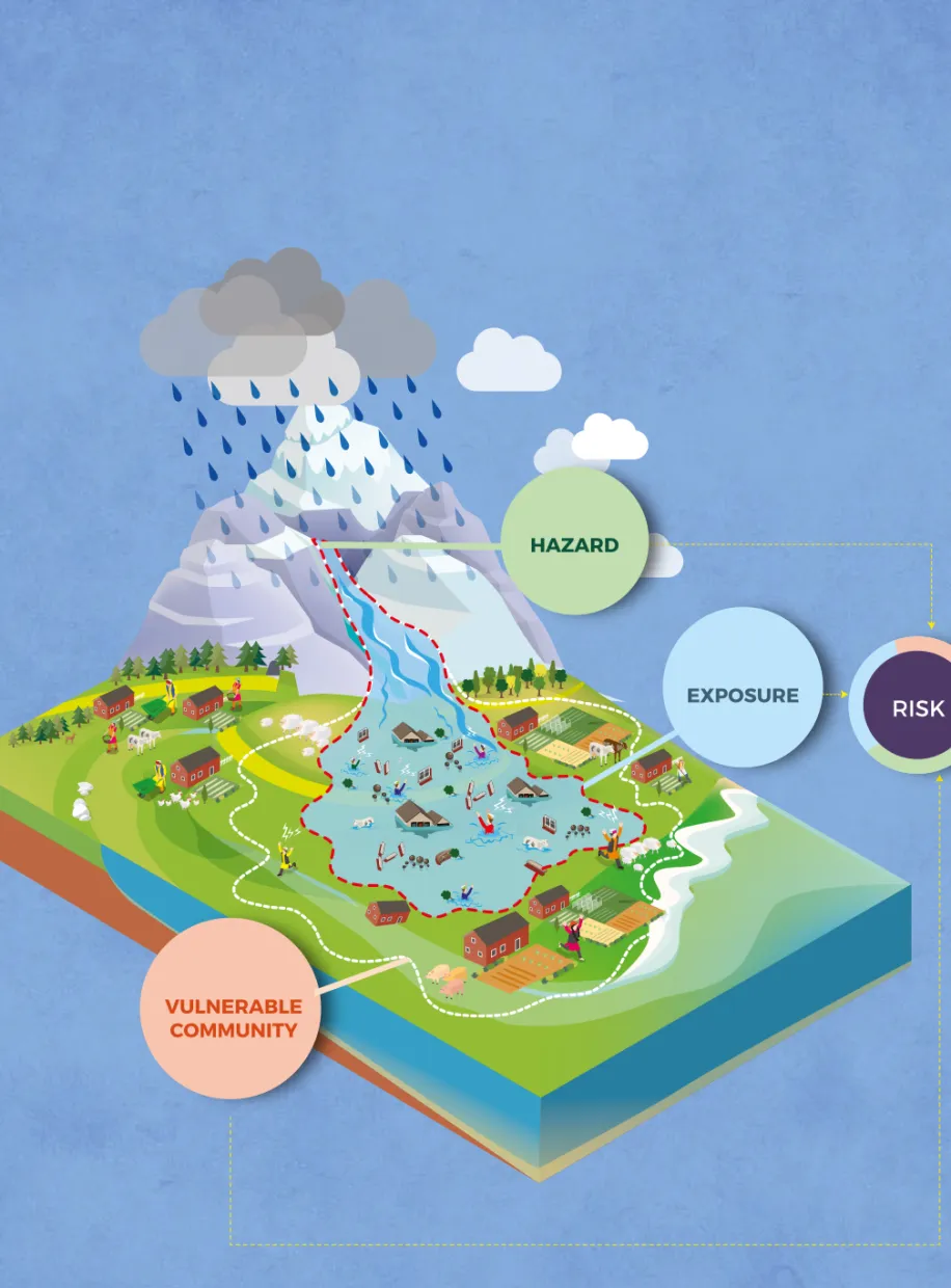
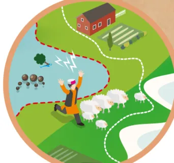
Risk is often represented as probability of occurrence of hazardous events or trends multiplied by the impacts if these events or trends occur. Risk results from the interaction of vulnerability, exposure and hazard (IPCC, 2014). For example, as illustrated in Figure 1, risk of flood-related impacts may result from a flood event (hazard) affecting infrastructure and people in flood plains (exposure) where the community is marginalized or response strategies are lacking (vulnerability). These three components are governed by changes in climate system as well as socio-economic processes.
Figure 1 Schematic overview of the core components of hazard, exposure and vulnerability coming together to create risk.
EXPOSURE
VULNERABLE
COMMUNITY
HAZARD
RISK
HIGH-QUALITY COMMON BASELINE DATA
R =
H
x
V
x
E
Common spatial and numeric scale (e.g.- all layers with standardized values 1 to 10)
3.
E
2.
V
EXPOSURE ASSESSMENT Large-scale mapping (Population density) Ground-level survey (People and assets) Remote sensing surveillance1.
H
HAZARD ASSESSMENT
Magnitude and frequency Slow onset vs. Rapid onset
Historical analyses Model-based results VULNERABILITY ASSESSMENT Community-level (Surveys, interviews) District to state-level (Socio-economic indicators)
Natural systems (Field or remote sensing surveillance)
INTEGRATED RISK ASSESSMENT
4.
R
Schematic overview of the integrated climate risk assessment framework showing the key steps and components required.
Figure 3
Figure 2
Framework showing the linkage between the core concepts of risk, vulnerability, hazard and exposure (Source: IPCC, 2014). Natural Variability Anthropogenic Climate Change CLIMATE Emissions and Land-Use Change HAZARDS VULNERABILITY EXPOSURE RISK SOCIO-ECONOMIC PROCESSES Socio-Economic Pathways Adaptation and Mitigation Actions Governance IMPACTSHAZARD
ASSESSMENT
Hazard includes both the slow onset events (e.g., increase in mean temperature or decrease in rainfall leading to impacts such as species extinction, vegetation change or groundwater shortages) and the fast onset events (e.g., floods including GLOF, heatwaves or landslides). These events may cause loss of life, injury, or other health impacts, as well as damage and loss to infrastructure, livelihoods and ecosystems. Defining and quantifying a hazard is the starting point for the assessment process, as it determines what it is that communities or systems are exposed and vulnerable to. Hazards from sudden onset events are defined on the basis of the intensity (also referred to as magnitude) and probability of occurrence (also referred to as frequency). Using this information, land area to be assessed is classified according to an assigned hazard level (ranging from low through medium to high). For example, GLOFs are sudden onset events which occur when there is a sudden discharge of a water reservoir that has formed near a glacier. A GLOF hazard assessment conducted for the entire state of HP helped in understanding the frequency and magnitude of the threat across the state, with the overall GLOF hazard for each tehsil categorized as low, medium or high(Allen et al., 2016). Once the current hazard situation was mapped, an assessment of how future changes in physical systems will influence the potential occurrence of GLOF was done. From a climate change perspective, this means using future model projections to determine how factors which contribute to or trigger GLOF events will change in the future.
Hazard is defined as the potential occurrence of a natural or
human-induced physical event or trend or physical impact that may cause loss of life, injury, or other health impacts, as well as damage and loss to property, infrastructure, livelihoods, service provision, ecosystems environmental resources (IPCC, 2014).
VULNERABILITY
ASSESSMENT
2
Table 1: Selected indicators characterizing vulnerability to floods Vulnerability components represented
Indicator (from Census of India, 2011)
Population <6 years of age Population >60 years of age Literacy rate Disabled population Home renters Derelict houses Water availability Medical facilities
Sensitivity, capacity to prepare, respond and recover Sensitivity, capacity to prepare, respond and recover Capacity to prepare, respond and recover
Sensitivity, capacity to prepare, respond and recover Capacity to recover
Sensitivity, capacity to respond and recover Capacity to prepare and respond
Capacity to prepare and respond
For example, a community living on a floodplain might be exposed to flood hazards but may not be vulnerable to floods if there are sufficient response strategies implemented, such as houses being built on raised platforms, etc. Likewise, a forest or another ecosystem may be exposed to a significant change in climate, but may not be vulnerable, depending on the species composition. The approach to conduct a vulnerability assessment depends primarily on the scale of assessment. While local- level assessments involving communities may be done through participatory approaches, macro-scale assessments typically involve indicator-based spatial mapping. For example, an indicator-based approach involving a series of quantifiable indicators from census data was used to determine the vulnerability component of the risk assessment for GLOFs in HP (Table 1) (Allen et al., 2016).
In this example, indicator values were standardized to a common range from 1 (indicating low vulnerability) to 10 (indicating high vulnerability), with the final vulnerability index simply calculated as the average across all standardized values. Advanced approaches may use differential weighting to emphasize more important drivers of vulnerability, but generally, such weighting is difficult to justify as it is perception based and not recommended for IHR where sufficient
Vulnerability refers to the propensity or predisposition to be adversely affected (IPCC, 2014). It is assessed by determining the sensitivity of the target system with regard to the hazard impacts, the capacity of the system to cope and adapt. A major distinction in the climate risk
assessment framework from the earlier vulnerability assessment frameworks (IPCC, 2007) is that the exposure component is now
considered independently of vulnerability, i.e., a community or system may be exposed to a climate-related hazard, but not vulnerable.
EXPOSURE
ASSESSMENT
3
Exposure can be assessed based on an inventory of elements located within an area in which hazards or adverse effects of climate change may be expected to occur. At large scales (state to district level), population density can provide an approximate indicator of the level of human exposure, while at local scale, assessments must quantify and map more precisely the people, infrastructure such as hydroelectric plants and assets that can be affected. For example, population density was used as an indicator to determine the exposure for GLOF risk assessment done for HP (Allen et al., 2016). Exposed elements may also refer to agricultural crops, forests and natural ecosystems, protected wildlife areas, etc. High resolution satellite or aerial imagery provides an important source for mapping such elements, and can keep track of land use changes.
Exposure refers to the presence of people, livelihoods, species or ecosystems, environmental functions, services, and resources, infrastructure, or economic, social, or cultural assets in places and settings that could be adversely affected (IPCC, 2014).
Flooding due to a cloudburst had claimed nearly 27 lives in Shat village, which is located dangerously close to Parvati River in Kullu district, Himachal Pradesh. Fifty-year-old Kamal Chand was the sarpanch of the village when the incident happened in July 1994.
INTEGRATED
RISK
ASSESSMENT
Firstly, the three layers of information must be aggregated to a common spatial scale. For adaptation planning, information is normally required at least for individual districts, and ideally, for blocks,
tehsils or villages. Secondly, the values for all layers must be
standardized to a common range (e.g., an index from 1 to 10) or categories (e.g., low to high), so that when combined, all three layers are equally represented. These steps were followed for GLOF risk assessment for HP, where the final risk map was calculated as a consequence of physical hazard, intersecting with vulnerable and exposed population (Figure 4).
4
An integrated risk assessment is done based on the underlying hazard, vulnerability and exposure assessment (steps 1-3). There are two primary considerations before integrating the hazard, vulnerability and exposure components into a complete risk assessment.
Figure 4
GLOF risk calculated for all tehsils in Himachal Pradesh(Source: Allen et al., 2016).Lake outburst probability:
GLOF Risk Assessment for Himachal Pradesh
100 km
GLOF paths
Integrated GLOF Risk High
The GLOF risk assessment for HP under IHCAP is one of the few published examples where the climate risk framework (IPCC, 2014) has been applied in totality to provide an end-to-end risk assessment. In principle, however, the framework should be applicable to provide risk assessment for a full range of climate-related threats. Table 2 provides an example of the risk components to be considered while doing an integrated risk assessment for a slow onset and a sudden onset event.
APPLICATION
OF RISK
FRAMEWORK
Table 2: Application of risk assessment for climate change adaptation
Sudden onset event
Example Example
Slow onset event
Climate risk for people and livelihoods due to loss of forest diversity
Assessment of impact on biodiversity due to change in climate parameters such as temperature and rainfall Local community-level assessments to establish how people depend upon and utilize forest ecosystems for sustaining livelihoods Assessments of who and where are the communities most dependent on forest ecosystem services
Flood risk for people and infrastructure
Flood hazard assessment for current and future conditions
Assessment of societal
vulnerability based on indicators and Census data
Population density and
assessment of built infrastructure (e.g. villages, roads) exposed to flood events
Hazard
Vulnerability
Exposure
RECOMMENDATIONS:
In view of the serious challenges being faced by people due to the observed and potential climate change risks in IHR, there is a need for fundable adaptation measures to be planned and implemented. Based on the experiences in Himachal Pradesh, particularly in Kullu (IHCAP, 2016), it is recommended to adopt a systematic approach to climate risk assessment across the Indian Himalayan Region to support evidence-based adaptation planning and implementation. Some of the specific recommendations are:
Evidence-based planning and implementation of adaptation measures is a pre-requisite for building resilience of mountain communities and ecosystems in the Indian Himalayan Region (IHR). Recognizing the pervasive and complex challenge that the communities face in IHR, the Swiss Agency for Development and Cooperation (SDC) together with the Department of Science and Technology (DST), Government of India, initiated the Indian Himalayas Climate Adaptation Programme (IHCAP). Under IHCAP, a pilot study was done for Kullu district, Himachal Pradesh in coordination with the Department of Environment, Science and Technology (DEST), Government of Himachal Pradesh, to provide an integrated assessment of climate vulnerability, hazards and risk for climate adaptation planning. This series of Science Briefs on specific topics represents the key messages drawn from the outcomes of the Indo-Swiss scientific studies for Kullu in simplified language to inform decision making.
•
Baseline data: The selection and acquisition of common baseline data (climate, socio-economic, environmental, etc.) is the most important ingredient for an integrated climate vulnerability, hazards and risk assessment. There are two key requirements regarding common baseline data: 1) an agreed reference time window which defines the current (e.g., 1980 – 2010) or the future (e.g., 2050 – 2100) conditions, and 2) agreed datasets from common sources. This enables the various contributing studies and assessed components to be brought together and compared, providing a robust scientific basis for climate adaptation and policy recommendations. Long-term baseline data for climate and hazards can be particularly useful to understand long-term trends and patterns and assess future threats.•
Integrated risk assessment:A robust assessment encompassing all three core components of hazard, vulnerability and exposure is required to provide the necessary evidence to support adaptation planning. The use of an integrated framework provides for assessments which combine concepts and approaches from both climate change adaptation and disaster risk reduction, and contributes to efficient planning for development.•
Consultations to translate scientific assessment to adaptation:Addressing climate change and reducing vulnerability to climate change in IHR requires a multi-stakeholder approach involving policymakers, planners, scientists/researchers and practitioners. It is essential to connect the scientific assessments with the perceptions of local communities and with the priorities of the government departments. This can be achieved through extensive consultations with local communities and the government departments which will enable translation of the findings of the scientific assessment into evidence-based adaptation planning and implementation.
•
Evidence-based planning and implementation:There is a need for evidence-based planning and implementation of adaptation strategies to ensure their sustainability in the long term. Evidence-based planning strives for the implementation of sound adaptation strategies that address both the environmental and societal drivers of climate risk. It also helps in identifying the most vulnerable sections of the society.REFERENCES
Allen, S.K., Linsbauer, A., Randhawa, S. S., Huggel, C., Rana, P., and Kumari, A. (2016). Glacial Lake Outburst Flood Risk in Himachal Pradesh, India: An Integrative and Anticipatory Approach Considering Current and Future Threats. Natural Hazards, 84 (3), pp. 1741-1763. doi
10.1007/s11069-016-2511-x
IHCAP, 2016. ‘Climate Vulnerability, Hazards and Risk: An Integrated Pilot Study in Kullu District, Himachal Pradesh’. Synthesis Report. India: Indian Himalayas Climate Adaptation Programme (IHCAP).
Available at http://ihcap.in/resources.html
IPCC, 2007: Summary for Policymakers. In: Climate Change 2007: Impacts, Adaptation and Vulnerability. Contribution of Working Group II to the Fourth Assessment Report of the Intergovernmental Panel on Climate Change, M.L. Parry, O.F. Canziani, J.P. Palutikof, P.J. van der Linden and C.E. Hanson, Eds.,
Cambridge University Press, Cambridge, UK, 7-22.
IPCC, 2012: Summary for Policymakers. In: Managing the Risks of Extreme Events and Disasters to Advance Climate Change Adaptation [Field, C.B., V. Barros, T.F. Stocker, D. Qin, D.J. Dokken, K.L. Ebi,
M.D. Mastrandrea, K.J. Mach, G.-K. Plattner, S.K. Allen, M. Tignor, and P.M. Midgley (eds.)]. A Special Report of Working Groups I and II of the Intergovernmental Panel on Climate Change. Cambridge University Press, Cambridge, UK, and New York, NY, USA, pp. 1-19.
IPCC, 2014: Summary for policymakers. In: Climate Change 2014: Impacts, Adaptation, and Vulnerability. Part A: Global and Sectoral Aspects. Contribution of Working Group II to the Fifth Assessment Report of the Intergovernmental Panel on Climate Change [Field, C.B., V.R. Barros, D.J. Dokken, K.J. Mach, M.D.
Mastrandrea, T.E. Bilir, M. Chatterjee, K.L. Ebi, Y.O. Estrada, R.C. Genova, B. Girma, E.S. Kissel, A.N. Levy, S. MacCracken, P.R. Mastrandrea, and L.L. White (eds.)]. Cambridge University Press, Cambridge, United Kingdom and New York, NY, USA, pp. 1-32.
Indian Himalayas Climate Adaptation Programme (IHCAP) Embassy of Switzerland
Swiss Cooperation Office India, Nyaya Marg, Chanakyapuri, New Delhi – 110021, India Phone: +91-11-49959570 E-mail: [email protected]