HAL Id: hal-01253560
https://hal.archives-ouvertes.fr/hal-01253560
Submitted on 25 Jan 2021
HAL is a multi-disciplinary open access
archive for the deposit and dissemination of
sci-entific research documents, whether they are
pub-lished or not. The documents may come from
teaching and research institutions in France or
abroad, or from public or private research centers.
L’archive ouverte pluridisciplinaire HAL, est
destinée au dépôt et à la diffusion de documents
scientifiques de niveau recherche, publiés ou non,
émanant des établissements d’enseignement et de
recherche français ou étrangers, des laboratoires
publics ou privés.
Architecture and tectonic evolution of non-volcanic
margins: Present-day Galicia and ancient Adria.
Gianreto Manatschal, D. Bernoulli
To cite this version:
Gianreto Manatschal, D. Bernoulli. Architecture and tectonic evolution of non-volcanic margins:
Present-day Galicia and ancient Adria.. Tectonics, American Geophysical Union (AGU), 1999, 18 (6),
pp.1099-1199. �10.1029/1999TC900041�. �hal-01253560�
TECTONICS, VOL. 18, NO. 6, PAGES 1099-1119 DECEMBER 1999
Architecture and tectonic evolution of nonvolcanic margins:
Present-day Galicia and ancient Adria
Gianreto Manatschal,
1 and Daniel Bernoulli
Geologisches Institut, EidgenOssische Technische Hochschule, ZurichAbstract. A comparison of the reconstructed southeastern
margin of the Tethys ocean with the present-day Galicia margin shows that although both margins are of different age
and had a different fate, their architectures and tectonic evolutions are very similar. Along both non-volcanic margins
the site of rifting shifted from a broad area in the future proximal margins to a localized area in its distal parts, accompanied by a change in the mode of extension. During the initial phase of rifting, extension was accommodated by symmetrically arranged listric faults which soled at
midcrustal levels, indicating that deformation in the upper crust was decoupled from deformation in the upper mantle along a hot and weak lower crust. During advanced rifting, extension was dominated by simple shear along low-angle detachment faults with a top-to-the-ocean sense of movement. These shallow crustal structures formed a series of breakaways in the continental crust and cut into mantle rocks, indicating that now deformation in the upper crust and in the upper mantle was no longer decoupled. Cooling and strengthening of the lower crust during an initial stage of rifting apparently led to localization of deformation and a different style of deformation, documenting that the tectonic evolution of nonvolcanic margins is largely controlled by the thermal state of the lithosphere. Seafloor spreading initiated only after exhumation and exposure of the subcontinental mantle on the ocean floor and may have been accompanied by a loss
of the yield strength of the upper mantle, due to a
combination of simple shear extension, asthenospheric uplift, and increased melt production.
1. Introduction
Present-day divergent, nonvolcanic margins record one of
the major plate tectonic processes, i.e., the rifting and breakup
of continental lithosphere and the exhumation of subcontinental mantle preceding the onset of seafloor
spreading. In present-day passive margins the reconstruction
of their early histories relies mainly on the interpretation of reflection seismic profiles, magnetic and gravity data, and, in
a few places along sediment-starved margins like the one of Galicia, on the analysis of samples collected by deep-sea drilling and from submersibles. By contrast, mountain belts
•Now at Ecole et Observatoire des Sciences de la Terre
UMR 7517, Universit6 Louis Pasteur, Strasbourg, France. Copyright 1999 by the American Geophysical Union.
Paper number 1999TC900041.
0278-7407/99/1999TC900041512.00
provide extensive outcrops of oceanic and continental
basement rocks, of overlying prerift, synrift, and postrift sediments, and of associated fault rocks. However, in these areas the continent-ocean transition is often tectonically
decoupled, the elements of the former margin are
dismembered, and only under favorable conditions can the
history of the margin be reconstructed. This is the case in a few segments of the Alps, particularly in the south Pennine- Austroalpine boundary zone of the eastern Alps and in the
southern Alps, where well-preserved rift-related faults allow for the palinspastic reconstruction of the passive margin and the ocean-continent transition zone.
One of the best investigated present-day continental
margins is the nonvolcanic margin west of Iberia from which a
wealth of data from deep-sea drilling, submersibles, and reflection seismic profiling is avalaible. Although the overall structure of the margin is well known and a large amount of excellent data exists, several contrasting models for the evolution of this margin have been proposed (compare Figure 3 of Reston et al. [1996]), and there appears to be little consensus on important questions such as the mode of extension (pure shear versus simple shear or a combination of both, symmetrical or asymmetrical margins) and the kinematics of the fault systems involved.
In this paper we shall compare the early history of the Cretaceous nonvolcanic margin of Galicia with that of a Jurassic margin of the Alpine Tethys which was involved in Alpine thrusting and nappe formation. Our comparison is
based on stratigraphic, structural, petrological, and
geochronological data from the eastern and southern Alps, both published and our own, on published geophysical and deep-sea drilling material and on personal observations of deep-sea drilling cores. We shall document the striking analogies in the architecture of these margins and reconstruct their tectonic and kinematic evolution from initiation of
rifting to mantle exhumation and beginning seafloor
spreading. Also, we shall discuss the mode and kinematics of detachment faulting and the role of the lower crust during rifting. We postulate that the similarities between the two margins and their common evolution from rifting distributed over a wide area to localized extension along low-angle detachment systems may be explained by a model that includes changes in the rheology of the continental lithosphere during progressive rifting. We argue for asymmetric rifting dominated by simple shear extension during the late phases of rifting, leading to the exhumation of subcontinental mantle, and for a lower plate position of both margins as opposed to the Newfoundland and Brian•onnais margins. We further document in detail the analogies between the Galicia and Adriatic margins, whereas in an earlier short contribution [Manatschal and Bernoulli, 1999] we outlined the general situation of the Galicia-Newfoundland and Adria- Brian•onnais margin pairs without a detailed reference to their structural, sedimentological, and metamorphic evolution.
1100 MANATSCHAL AND BERNOULLI: GALICIA AND ADRIA MARGINS
2. Paleogeographic and Tectonic Framework
2.1. General Situation
Late Triassic to Early Cretaceous rifting and opening of the different segments of the Mesozoic (Neo-)Tethys spatially
followed, in the Atlantic and western Mediterranean area,
approximately
the Variscan orogeny. The resulting ocean
basins were part of an equatorial
spreading
system which
extended from the Caribbean to the eastern Mediterranean area
and beyond, including the central Atlantic, the eastern Mediterranean, the Liguria-Piemonte ocean, and the Vardar- Meliata ocean to the east (Figure l c). The evolution of these different branches of Tethys was determined by the
movements of the North American, the African, the Eurasian,
and the smaller Iberia and Adria plates (Figure l c) [cf. Ricou, 1994]. The evolution of the Liguria-Piemonte ocean, from which most of the Alpine ophiolites are derived, was
contemporaneous
with and kinematicall•)"--li•'ked
to the
opening of the central Atlantic in the Jurassic and separated
Eurasia from Adria. In the Early Cretaceous the Iberian plate
separated from Laurasia and migrated eastward, leading to the
opening of the Iberian Atlantic, the Bay of Biscay, and
possibly also of another small ocean basin, the Valais ocean (Figure lb) [cf. Starnpfii, 1993]. Rotation of Iberia was
kinematically linked with the opening of the Bay of Biscay and may have been associated with minor margin-parallel transfer movements along the west Iberian margin; however, most of the admittedly oblique extension was accommodated by the emplacement of oceanic crust and lithosphere. The different segments of the Atlantic-Tethyan ocean system opened at different times, and the closing of the Liguria- Piemonte segment was contemporaneous with ongoing spreading in the central and Iberian Atlantic and the opening of the North Atlantic (Figure lb).
2.2. The Galicia Margin
The Galicia margin off NW Spain and Portugal (Figure 2) is a typical example of a non-volcanic, sediment-starved margin. It resulted from rifting and final breakup between the North American and the Iberian plates during Early Cretaceous time (Figure lb). From this margin and its southern prolongation, a wealth of reflection seismic, magnetic, and gravity data were published, and rock samples are available from expeditions of the Deep Sea Drilling Project and the Ocean Drilling Program (Legs 47B, 103, 149, and 173), dredging, and submersible cruises. In this paper we shall concentrate on the northern portion of the Iberian margin, id est the Galicia margin west of the Galicia province in northwestern Spain. This portion of margin can be subdivided into three segments: the Interior and Porto Basins, Galicia Bank, and the Deep Galicia Margin (Figure 2). These segments can be distinguished by their different bathymetry and geological evolution during rifting.
2.2.1. The Interior and Porto Basins. The north-south trending Interior and Porto Basins form the proximal part of the margin and are considered to be the northward extension of the on-land Lusitanian Basin [Montenat et al., 1988]. The two basins are bounded by normal faults which trend NNE- SSW and NW-SE and dip toward the basin centers, resulting in an assembly of moderately tilted blocks along the flanks and near-symmetrical grabens in the basin centers (Figure 2c). Transfer faults with a NE-SW to ENE-WSW orientation segment the basins. As no wells have been drilled in the Interior Basin, the reconstruction of its sedimentary and stratigraphic evolution is based mainly on correlation with
,A)
• Europe
...
'"'"'"--•
oceanic
units
(including
[---5-]
Iberia
cover)
• Afri!a
... • Adria
...
...
•• ... (B)
(c)
•½'•:•
oceanic
crust
5•' subduction ¾-•x sp,
zone
rioges
reading
Figure 1. (a) Tectonic sketch map of the present-day west Mediterranean area showing the distribution of the European,
Iberian, Adriatic, and African continental areas and the distribution of the tectonic elements derived from them. Oceanic units are remnants of the Mesozoic Tethys. (b,c)
Large-scale paleogeography reconstructed for the Late Cretaceous (Figure lb) and for the Late Jurassic (Figure l c). AA, Austroalpine; B, Briam;onnais; FC, Flemish Cap; GM, Galicia margin; IA, Iberian Atlantic; LP, Liguria-Piemonte
MANATSCHAL
AND BERNOULLI:
GALICIA
AND ADRlA MARGINS
1101
(a)
,.• .... • • • • ,. •p• ... 43o•
GP
101-
A • o oo o o • 89• -m 4 .... / Gahoamargi. L • ,• •u 12 ) 901 ' • . Iberi•byssal IBERI•, IBE•IA
ABYSSAL
PLAIN:?
13 ø 12 ø 11 o 10 ø
(b) Deep Galicia Margin (Seismic
line GP 101)
[km], Peridotite
Deep
Galicia
Margin_
[km]
0 vv Ridge
• •
b_F0
4:(• 10km
• • ... : ... __ .... •-7%7 ..•4
...,,.:.:.:.::::: ... ,.:::•:•:• ......
...
,_ .
... Moho ...
(c) Galicia Bank, Interior
and Porto Basins
(Seismic
lines
GAP 106, 014, 018)
[km]
W Galicia
Bank
Interior
Basin
E [km]
o4
10 km
[km]
[km]
W
Interior
Basin
Porto
Basin
E _ o
10 km
(d) Iberia Abyssal Plain (Seismic
line LG-12)
[km]
0W
c• oo r,.. LOE [km]
01 o oo•o 10km o
12
.
i--i": !-i
:- ::',':•-',•:-':
',,,
,,...
12
i
I p0strift
sediments
Iiii::"'""-:":--':':2:..•ii:iri•iii•!.."..",..:•!
iiii:.ii:il
synrift
sediments
ili
•j•
' sediment
basement
prerift
:(.,•
serpentinized
mantle
Figure
2. (a) Map
of the
Iberian
margin
west
of Galicia
and
Portugal
with
the
locations
of Deep
Sea
Drilling
sites
and of seismic
lines GP 101 and GAP 106, 014, rind 018. Cross-hatched
band marks
the peridotite
ridge.
PS, Porto
seamount;
VS, Vigo seamount.
(b) Seismic
line GP 101 across
the Deep
Galicia
Margin
(after
the
work
of Mauffret
and
Montadert
[1987],
discussed
by Pinheiro
et al. [1996].
Numbers
refer
to Ocean
Drilling
Program
(ODP)
Leg 103 Sites.
S, S reflector.
(c) Seismic
lines
GAP 106,
014, and
018 across
the Galicia
Interior
Basin
(after
the work
of Murillas
et al. [1990],
discussed
by Pinheiro
et al. [1996]).
(d) Seismic
line
1102 MANATSCHAL AND BERNOULLI: GALICIA AND ADRIA MARG1NS
wells in the Porto Basin and in the Deep Galicia Margin and on seismic stratigraphic correlation. In the Interior Basin, several events of extensional deformation can be defined, of which the most important is interpreted to be of Valanginian age [Murillas et al., 1990].
2.2.2. Galicia Bank. Together with the Vigo and Porto seamounts, Galicia Bank forms a NNW-SSE trending
alignment of elevated highs which separate the Interior Basin
from the Deep Galicia Margin. Several authors [e.g., Boillot et al., 1979] interpreted these highs as former horsts originating from Mesozoic rifting and uplifted during Tertiary compression. However, the geometry of the reflections, the nature of the seismic stratigraphic units, and the architecture
of the basins are different east and west of Galicia Bank,
suggesting that this ridge separates two different tectonic
provinces of the margin.
2.2.3. Deep Galicia Margin. The Deep Galicia Margin includes the distal part of the margin and the continent-ocean transition, and it is characterized by N-S trending tilted fault blocks of continental basement and prerift sediments overlain by relatively thin synrift and postrift sequences. These tilted blocks are underlain by a prominent reflection, the so-called S
reflector (Figure 2b) [de Charpal et al., 1978; Boillot et al.,
1988]. The S reflector can be followed oceanward toward a ridge consisting of serpentinized peridotites, the so-called
peridotite ridge [Boillot et al., 1980]. This ridge is supposed
to separate true oceanic crust to the west from a "transitional" and thinned continental crust to the east. Rifting in the distal margin and breakup between Newfoundland and Iberia are thought to have taken place from Valanginian to AptJan times
[Boillot et al., 1988].
2.3. The Adriatic Margin
2.3.1. Alpine tectonic evolution. By and large, the Alps are
the product of continental collision between the Eurasian, the
Iberian, and the Adriatic plates (Figure 1). This collision was
preceded by the opening of three different oceans, the Vardar-
Meliata (-Hallstatt) ocean to the east of Adria, the Liguria- Piemonte ocean between Adria and Brianqonnais (a possible
promontory of the Iberian plate), and the Valais ocean
between Brian•onnais and Europe. In the Alps, convergence
started in the Early Cretaceous with the elimination of the Vardar - Meliata ocean and the collision with another
microplate to the east [Froitzheim et al., 1996]. As part of this
orogeny, a thrust wedge propagated from the northeastern margin of Adria to the west, leading to a nappe edifice in the
Austroalpine complex and its margin to the Liguria-Piemonte
ocean. During this event the ocean-continent transition of the
Piemonte-Adriatic boundary zone was telescoped into a
number of thrust sheets.
During the Late Cretaceous and early Tertiary, tectonic activity shifted to the west, and most of the Liguria-Piemonte ocean was subducted below the Adriatic plate (Figure lb). During the Eocene, subduction and related metamorphism
affected also parts of the Brian•onnais, the Valais ocean, and,
later on, the lower part of the European lithosphere, whereas
the upper crust was delaminated and accumulated in a number
of crystalline basement and sedimentary decollement nappes
[Pfiffner et al., 1997]. The thrust sheets derived from the Adriatic margin including the most continentward parts of the
Liguria-Piemonte ocean, i.e., the Platta nappe, were always part
of the upper plate and escaped subduction and high-pressure metamorphism.
The Tertiary continent-continent collision with the Brian•onnais and with Europe affected the south Pennine-
Austroalpine boundary zone of Grisons only weakly. The
Cretaceous nappe edifice was thrust more or less "en bloc" to the north and over the middle and north Penninic units (Brian•onnais and Valais). In contrast, a southward propagating thrust wedge affected the domains of the Adriatic margin located today in the southern Alps, which were less
deformed by the previous Late Cretaceous orogeny
[Schumacher et al., 1997].
2.3.2. The south Pennine-Austroalpine transect. The evolution of the Adriatic margin can be reconstructed along two transects in the Alps (Figures 3 - 5). In Grisons the elements of the former margin have been telescoped by thrusting during the Late Cretaceous; however, the ocean- continent transition has never been subducted to great depth, and metamorphism did not exceed lower greenschist facies along our transect [Ferreiro Mi•hlmann, 1995, and references
therein]. West directed shortening was of the order of 200 - 300% (about 100 - 150 km). The resulting nappe edifice
includes
(from top to bottom)
the upper
Austroalpine
(Otztal,
Silvretta-Sesvenna, and Campo-Ortler), the lower Austroalpine (Bernina-Ela and Err nappes), and the south Pennine nappes (Arosa zone, Platta nappe, and Forno-Malenco
complex) (Figures 3a and 3b).
Late Cretaceous nappe stacking was followed by extension which occurred still during the Late Cretaceous [Froitzheim et al., 1994, 1996]. The amount of extension, however, was small compared with the amount of previous shortening.
Compression and extension were parallel to previous
extension during Jurassic rifting, and part of the Jurassic
basins was inverted along rift-related east dipping faults.
During this process, higher crustal levels including
sediments and shallow basement were detached from their
original basement;
however,
the coaxial
Cretaceous
phases
of
deformation allowed us to visualize a relatively
straightforward
kinematic
inversion
of the margin
(for details,
see Froitzheim
et al. [1994] and Manatschal
and Nievergelt
[1997]). According to this kinematic reconstruction, the
higher nappe units are derived from the proximal
margin
(upper Austroalpine)
whereas
the lower nappes
represent
the
distal margin (lower Austroalpine,
Err and Bernina
nappes)
and the transitional crust (Platta nappe). Because of the
detachment
of shallow crust and sediments,
the deep
structures of the margin are not preserved in our transect;
however,
deeper
crustal
levels
of the prerift stage
are exposed
to the south in the Austroalpine
Margna nappe and the
ultramafic Malenco complex [Hermann et al., 1997; Miintener
et al., 1999]. In contrast, shallow crustal structures of the
proximal margin (Ortler-Silvretta) [Eberli, 1988; Froitzheim,
1988; Conti
et al., 1994],
the distal
margin
(Err) [Handy
et al.,
1993; Manatschal and Nievergelt, 1997) and of the ocean
Figure
3. (a) Tectonic
sketch
map
and distribution
of early
Mesozoic
faults
of the western
southern
Alps
and
the south
Pennine-Austroalpine
boundary
zone, Italy, and southeastern
Switzerland
(modified
after Bernoulli
et al. [1990] and SchOnborn
[1992]). (b) Profile across
the south
Pennine-Austroalpine
units in Grisons
(modified
after Froitzheim
et al. [1994] and Manatschal
and Nievergelt
[1997]). (c) Profile across
the
southern
Alps [after Schdinborn,
1992]. For traces
of the profiles,
see Figure 3a.
MANATSCHAL AND BERNOULLI: GALICIA AND ADRIA MARGINS 1103
(a)
GH : Gozzano High
IM : II Motto
MG: Monte Generoso Basin MN: Monte Nudo Basin P : Parsettens PL: Piz Laviner
Ix x x I Tediary granitoids
I I South Alpine and Upper Austroalpine sediments t ... t South Alpine and Upper Austroalpine basement I:' :' :':'1 Lower Austroalpine and Canavese sediments
t-'-'1 Lower
Austroalpine
basement
--' ;:• Margna- Sesia- Dt. Blanche
•
Liguria-Piemonte
ophiolites
and sediments
I I European, Valais and Brian(;;onnais units • Rift-related faults ill ... Campo ... ... S-o'uth"e rn--Alps ... ... _. ...
Milano
•
0 km 5OProfile across the South Penninic-Austroalpine units in Grisons
(b) w Surss
Engiadin'Ota
E
[k.m]
-
Err
nappe •- Bernina
nappe
Upper
AA
[km]
_.
_•_7__;_•
...
2
B"
\ ,Bernina
nappe
"---:'-;'---,.,
- . ,
1
5 km
(C) N
Profile
across
the Southern
Alps
s
•
,-,. •
• ..,
[km]
..4 ... 0
-10
C
, ,5 km
i i ! iC'
European-Brian(;onnais Units Ligurian-Piemonte units (Platta nappe)
:,::• Tertiary flysch • ... basalts, gabbros, and postrift sediments
-• ... serpentinites
Adriatic units (Austroalpine and Southern Alps)
• Upper Cretaceous flysch and younger sediments
-œ• Jurassic to Cretaceous sediments • Permo-Triassic volcanics and sediments
1104 MANATSCHAL AND BERNOULLI: GALICIA AND ADRIA MARGINS
floor sequence (Platta) (Dietrich [1969, 1970] and this paper) are well preserved along our transect. Younger, N-S directed shortening and associated transcurrent faulting during Tertiary time are of subordinate importance within our transect [Froitzheirn et al., 1994] and are not considered in the kinematic inversion and palinspastic reconstruction.
2.3.3. The southern Alps transect. The southern Alps in southern Switzerland and northern Italy preserve another transect across the same margin to the south (Figures 1, 3a, and 3c) [Bernoulli et al., 1979; Winterer and Bosellini, 1981]. Basement and sediments of the proximal margin segment are well exposed in the central portion of the southern Alps north of Milano, but the distal part, situated in the Canavese zone, is poorly outcropping and heavily deformed (Figure 3a). A precise reconstruction of the distal margin is therefore not possible along this transect. In the central Lombardian segment, north-south shortening during the Late Cretaceous and Tertiary was between 80 and 100 km and parallel to the strike of the Jurassic rift faults which were partly reactivated as transcurrent faults and oblique ramps within the east-west trending fault-and-thrust belt (Figure 3c) [Schdinborn, 1992].
Nevertheless, a few of the Jurassic rift faults can be followed
into the basement [Bertotti, 1991], and the anatomy of the proximal margin can be reconstructed from the depositional geometries of the well-exposed synrift sediments [Bertotti et at., 1993].
Both sectors of the margin, the northern and the southern transect, are divided into segments with a characteristic structural and sedimentary evolution which is discussed in section 3. These segments are t¾om west to east (1) a distal margin (Err in the north and Canavese in the south), (2) a
boundary zone between the distal and the proximal margins
(Bernina-Ela in the north and Gozzano in the south); and (3) a proximal part of the margin (Ortler-Silvretta in the north and
Lombardian basin in the south) (Figures 4b and 4C).
3. Anatomy of the Margins
3.1. Continental Crust and Prerift Sediments3.1.1. Galicia margin. The continental basement of the Galicia margin is known from very limited samples from drill holes and submersible dives, and its age and tectonic evolution are not well defined. Plutonic and metamorphic rocks [e.g., Capdevila and Mougenot, 1988] are locally overlain by thick, weakly metamorphosed sandstones, dolomites, and volcanoclastics of Late Devonian-early Carboniferous age [Marnet et al., 1991]. A similar sequence is found in the Ossa-Morena zone in Portugal and southern
Spain. This suggests that the Galicia margin is underlain by
the northwestward prolongation of this external zone of the Variscan orogen. The occurrence of undeformed lower Paleozoic rocks at Flemish Cap in the conjugate Newfoundland margin [King et al., 1986] indicates that this latter area was situated outside the Variscan belt and that the breakup between Newfoundland and Iberia followed more or less the Variscan front [Capdevila and Mougenot, 1988].
Lower crustal rocks have not been found so far along the Deep Galicia Margin, except for a few granulite samples. Fission track ages on zircons from two of them were Carboniferous to Early Permian [Fuegenschuh et at., 1998], indicating that these rocks cooled to about 250øC at this time and were at upper crustal levels when rifting initiated.
Little is also known about the prerift sediments. In the Deep Galicia Margin, sandstones with volcanic detritus, interbedded with shaly dolomites and conglomerates, are
overlain by about 400 m of Tithonian shallowwater
carbonates. On Galicia Bank the basement is separated from
these carbonates by a horizon which shows evidence of soil
development during Mesozoic emergence [Marnet et at., 1991]. Thus the area occupied by the Galicia margin was in shallow water or at sea level before rifting started in
Cretaceous time.
3.1.2. Continental crust and prerift sediments of the
Adriatic margin. In the southern Alps a pre-upper- Carboniferous (Variscan) metamorphic basement underlies
the upper Paleozoic and Mesozoic formations. Some controversies exist about the importance and significance of earlier, Cadomian or early Paleozoic events which are documented by an increasing amount of radiometric data.
Amphibolite-grade metamorphic mineral assemblages in the Variscan basement document extremely low-pressure (p), high-temperature (T) metamorphism as it is characteristic for extensional areas with a high heat flow [e.g., Lardeaux and Spalla, 1991]. Post-Variscan, Early Permian (290 Ma)
extension is also documented by syntectonic intrusions of gabbros along the crust-mantle transition in the Ivrea zone
[Quick et al., 1994], accompanied by granulite formation and partial melting in the lower crust and the emplacement of granitic batholiths in the middle and upper crust, both
contemporaneous with the formation of sedimentary basins and the extrusion of andesitic, dacitic, and rhyolitic volcanic rocks at the surface.
Like in the Ivrea zone, gabbros intruded during the Permian at the crust-mantle transition of the Malenco complex [Hermann et at., 1997]. These gabbros crystallized at 10 - 12 Kbar, indicating that the Moho was at that time at about 30 km depth. Pressure-temperature-time data obtained from the gabbros and the surrounding granulites and ultramafic rocks document isobaric cooling which lasted for
about 50 Myr, before these rocks were exhumed during Late
Triassic and Early Jurassic rifting [Miintener et al., 1999].
The sedimentary prerift sequence of the Adriatic margin
starts with Upper Permian to Middle Triassic continental clastics of variable thickness. These subaerial deposits are overlain by Middle to Upper Triassic dolomites, limestones,
and minor evaporites and shales. Varying thicknesses indicate differential subsidence and local tectonic activity, possibly in connection with ongoing transtensional/
transpressional movements [Handy and Zingg, 1991] or events connected with the evolution of the Vardar-Meliata ocean to the east [Bertotti et al., 1993]. The prerift sequence is
generally thicker (1 - 5 km) in the east (upper Austroalpine) and south (southern Alps) and thinner (< 500 m) in the lower
Austroalpine in the northwest.
3.1.3. Similarities in the prerift history of the two
margins. The very different quality and density of data, as
well as the poorly known crustal evolution of the Austroalpine and south Alpine areas during the Permian and Triassic, make a direct comparison of the continental
basement and the prerift sedimentary sequence of the two
margins difficult. There are, however, important similarities at
least as far as the lower Austroalpine and the western south Alpine basement are concerned. For both margins we can
assume (1) a Variscan overprint of the continental crust and (2) an isostatically equilibrated, about 30 km thick continental crust before initiation of rifting, as is indicated by limited subsidence and shallow water conditions
prevailing over a long time before initiation of rifting and by the p-T-t data of the mantle-crust boundary in the Malenco
area [Miintener et al., 1999]. We therefore think that the
MANATSCHAL AND BERNOULLI: GALICIA AND ADRIA MARGINS 1105 c o • Lt,9 cO 8•9 • 6•9
E E E
._ -a E o o Q. 09 ..• ..• o o L• c + I I i1+ ,- .-1106 MANATSCHAL AND BERNOULLI: GALICIA AND ADRIA MARGINS
tectonic and thermal evolution before the onset of rifling and that the conditions at the onset of rifting were similar for the two margins.
3.2. Rift Basins and Synrift Sediments
Rift basins, bounded by normal faults and tilted blocks, are the most prominent structures defining the architecture of rifted margins (e.g., Figures 2b and 2c). Because the formation of basins and the deposition of synrifi sediments are closely linked, they will be discussed together in this section. Rift- related structures, such as the intrabasement reflections and
detachment faults, will be discussed in section 4.
The age of the onset of rifting and therefore also the duration of rifting depends on the way rifling is defined. In the Alpine Tethys, Permian and Middle Triassic extension have been interpreted by several authors as precursors of the opening of the Tethyan ocean [e.g., Winterer and Bosellini, 1981]. Likewise, Late Triassic to Early Jurassic crustal extension and basin formation in the Iberian and North Atlantic area have been related to the later opening of the corresponding ocean basins; however, these early extensional events are separated from break-up by a time interval of some
100 Myr during which tectonic activity and subsidence were
discontinuous. Moreover, Permian and Triassic extension and
related subsidence occur over large areas of northern Europe
which never evolved into oceanic areas. In this paper we shall
refer to rifting as the extensional processes continuously and progressively leading to break-up and continental separation. In the Alpine Tethys and along the Iberian margin, crustal extension leading to continental separation lasted about 30- 50 Myr.
3.2.1. Rift basins and synrift sediments along the Galicia
margin. Along the Galicia margin, rifting apparently started in the Interior Basin during the Valanginian, as postrift sedimentary sequences of assumed Hauterivian to Aptian age drape the riff basins [Murillas et al., 1990]. Data from Deep Sea Drilling Project (DSDP) Leg 47B and Ocean Drilling Project (ODP) Leg 103 indicate that rifting along the Deep Galicia Margin was later, from Hauterivian to Aptian time [Boillot et al., 1989a]. These scanty data suggest that rifting along the Galicia margin was diachronous, beginning in the Interior Basin and shifting only later to the Deep Galicia Margin. A similar spatial and temporal evolution of rifling is
reported from the transect farther to the south between the
Iberian Abyssal Plain and the Lusitanian Basin. In this transect, rifting started in late Oxfordian-early Kimmeridgian
time in the proximal Lusitanian
Basin [Wilson et al., 1989]
and shifted after the Tithonian, probably during the early
Valanginian, to the distal Iberian Abyssal Plain [Wilson et al.,
1996]. Likewise, the formation of oceanic crust started earlier
in the south (136 Ma) from where it propagated to the north
[Whitmarsh and Miles, 1995].
In the Interior and Porto Basins most of the basins 'are
bounded by antithetic high-angle and/or listric normal faults, and the overall geometry is that of a horst and graben
structure (Figure 2c). The sedimentary fill is much thicker
than that in the more distal basins of the Deep Galicia Margin (Figures 2b and 2c). Initial faulting led to drowning as well as
to uplift and erosion of parts of the Tithonian-Lower
Cretaceous carbonate platform and to the accumulation of a thick clastic sequence in the depocenters of the Porto Basin.
Toward Galicia Bank the rift basins become shallower, and
normal faulting appears to have been of lesser importance. In the Deep Galicia Margin, rift basins are bounded by west dipping normal faults separating fault blocks tilted toward
the east, i.e., toward the continent. These blocks are underlain
by a strong reflection, the so-called S reflector. The size of the blocks decreases toward the ocean. The fault blocks are cut off and/or slightly offset by a discrete pattern of transfer faults which strike east-northeast or east-southeast and show a quite
regular spacing of about 20 km. The blocks overlying the S
reflector consist of continental basement rocks and prerift sediments and are unconformably overlain by a synrift sequence including marlstones, turbiditic sandstones, claystones, and hemipelagic limestones interbedded with debris flow deposits of Hauterivian to early Barremian age. In
the half grabens these synrift sediments are up to 1 km thick but thin and locally pinch out toward the highs of the tilted
blocks along onlap surfaces and internal unconformities [Boillot et al., 1989a]. Quartzo-feldspatic sandy turbidites in the basins west of Galicia Bank are derived from the erosion of a subaerial, narrow high occupying the present area of Galicia Bank [Winterer et al., 1988]. This implies tectonic uplift of Galicia Bank simultaneously with rifting and subsidence in the Deep Galicia Margin.
3.2.2. Rift basins and synrift sediments of the Adriatic margin. In the Alpine transect, rifting started in the areas which were to become the proximal parts of the fhture margin(s). In the Adriatic margin the geometry of the rift basins can be reconstructed from the relationships between prerift, synrift, and postrift sediments, their depositional geometries, and their relations to Jurassic fault scarps. At places, the Jurassic faults have not been reactivated, and their geometry can be observed directly [Eberli, 1988; Froitzheim,
1988; Bertotti, 1991; Conti et al., 1994].
The first rift basins formed during the latest Triassic. They were depressions only a few kilometers wide in which coarse resediments, derived from active fault scarps, were deposited [Bertotti, 1991]. The shape and orientation of these basins could suggest a left-lateral component in their formation. During the Rhaetian, extension continued; however, because
of high sedimentation rates, the faults had no major morphological expression [Bertotti et al., 1993].
In the early Liassic the number of active faults decreased,
and strain was gradually concentrated along a few major
crustal faults. These faults controlled the sedimentation in the adjacent basins, which was characterized by olistoliths, coarse lithic breccias, slump complexes, and calcareous turbidites
interbedded with hemipelagic spongolithic limestones [Bernoulli, 1964; Eberli, 1988]. Locally, these basinal
deposits reach a thickness of a few kilometers. On the
sediment-starved highs, submarine faulting produced a network of sediment-filled fractures (neptunic dikes) and complex tectono sedimentary breccias. Rifting in the
proximal parts of the future margin ceased in the middle to late Liassic; however, some of the faults became inactive even
earlier and were sealed by lower Liassic (upper Sinemurian) sediments (Figures 5 and 6f) [Eberli, 1988; Conti et al.,
1994].
In the southern Alps, facies and thickness of the synrift sediments abruptly change across these Jurassic faults, and their depositional geometries define the rift basins as half- grabens, up to 30 km wide (Figure 4c) [Bernoulli, 1964; Bertotti, 1991]. The Lugano-Monte Grona fault bounding the Late Triassic-early Liassic Generoso basin to the west can be traced from the surface into the Variscan basement over a
horizontal distance of more than 30 km (Figure 7). This fault
was active as a top-to-the-east normal fault and can be traced
from the brittle into the ductile field where quartz mylon,2tes formed. On the basis of the depositional geometry of the synrift sediments and on the temperature conditions during
deformation, Bertotti [1991] could show that the fault had a
MANATSCHAL AND BERNOULLI: GALICIA AND ADRIA MARGINS 1107
LLI
OOs u! J__LAg_l_
. • .. ::•.:.?;'::..•':.i'; ... ' ... '"' '?...-:'. -:-i:•** ... ...;:..::.• ... ,- .... • ...•:..•'/i!!: ... ...
...
....
•..½•.,•
--'• :.
.. . • •"•
.... i.i!
• •
..'
::•::
...
?•
ß
•;- :::•::::...:.,:..-'•._•
:-•'
...
• •. ..??'.'":"'•:' ...
....
.• .:.:,:::,:,, ... •. .•'-:::.:.-. . ... - ... ..,..,:,, ... .• ::;.';•...:.
..•:.,?.,/'½
..
*'"'..½
':'.':"*
.½
..:.._•"'
'""*
.
•'•
:.;***;;•'"'
•'. • ...
...
:•½;
...
- ...• .•, '....:.•
.•
•-
:½-•a•"*'•;•;:;;
•::".•/" ' •'.'"'...• .'-
• '•:;½.,•v•:.•:,.•;•:.•,z.,.,.:•.:.:,:::*'•.-•:•:...•:}?: :.•'.• ½:•: .<h::•'.', • '.' • :;:: .• ... •'. ... , ... •" '•'•:;•:'.• ::•;:':':'."::•:;•,•.•:..:•: ß •-•:•'•:•"...
. ...• ,• .',$•.,•
•'• ... . ....::•. -:
z*'..•:
...•.:•
.•?½m::•:r•,::.,:-.•:.%:•.,'•"•:½•'•?**•...::½,•:.•?.:•
.. ':%:'. • .... :.';½"' '•:f•'.'•:...
:':'- , ...
.•;:,• ...
:;•:;;;:;,::
"'"'""•"•:'•••••':'""'•"'•'•::'..:,:
:.'•
.:,
...
.&•. ':::,:**"%',", ....-.:::,:;::,:.:..-.:,:;•,::::.
:..:..-:;•
...
::'-?'---••.•;:
X:4-..-:g-;-::,..-•.•?•---•-••••••,...:-:.:;•.,.;:.
'-.---.,•.--•:::•:
:•;•;
...
•:•;•`•"•••:•;•;i•:•:•:•;•;;;;(•:•`•:`•``•;•
...
'.:.;:•E•..½•;?:*::'"':':'<::?
'"•'D%:'
"•::'?•24•:::•%..
•..':•.:•.'
:;;•:::..7"? '• -'•'•""• '••'*'"•'"""•"•'•'••':•"•'":•:•.;, .... '•':•--•:•:•:'•"'•']• .... ,:-;... .•, .A. ,.•..• :::%::: ::•'::.-...*':; . :•.:' •.,.,.,..:... "'*•:' •' '•::•:::'• •'.,:.:.':"•:•'•'•'• .... •;:':•.:'•::% :"•"•...,.., ... -•:4•:•::':•-::m:•::..'-.'•.'::-'-:.•'•"•;'.•'"".. '"' :;':•-*- '• •'• .•.• ... :,::•.• •::•E.::•'•:;•:•' .... -':;• .•. •s•.•::-.:-•:.;' :x'•:•.. ' :::.•,•- •.:.:.x.. : '. .'.•.::•-. ' •'•..' ':• .... ::•,•.• ... *.•::.'.• ':•:•..'";gA•,•. *: • ... .:..::' ':•..,.." •;;:•- •:'•:: '"• ... ::::;::::: .:• ':::• ... •::..•g.:...•..,•:.. •..•: ß . ...:... .• .. .... .•.::: ...., ... ..:..,. ... ..., ..•.. ... ..:,,:.., :... ..;.: %:. -•;::•?•:.'•¾??. ... •. . ..,..;,•.• ... .:x,.: :.-:•:--- -• ... .,•. ..::-...:-:- ... "':'• '- ' "':w:'":2:.'•:• .... .•g•?•?•:%•`:•````:::::•`.•F. ::`•.`:.`.•``•,••:::```:•.A.•:.•:. .``•:•*•:•`•:::.... "::.'"": ... •':} './'?-e-: ... ?.?',,: •-.,--.- ,• ":' ... ....,...,:.. *':,:.•:•.•...., . - .... ..•- • .... , •,..• ... :.:;:. ;•''•
...
,,,.,,,•
•',½•
•;•;•5.c'""<;.;%.;
,.
...
.
...
•..
...
.
...
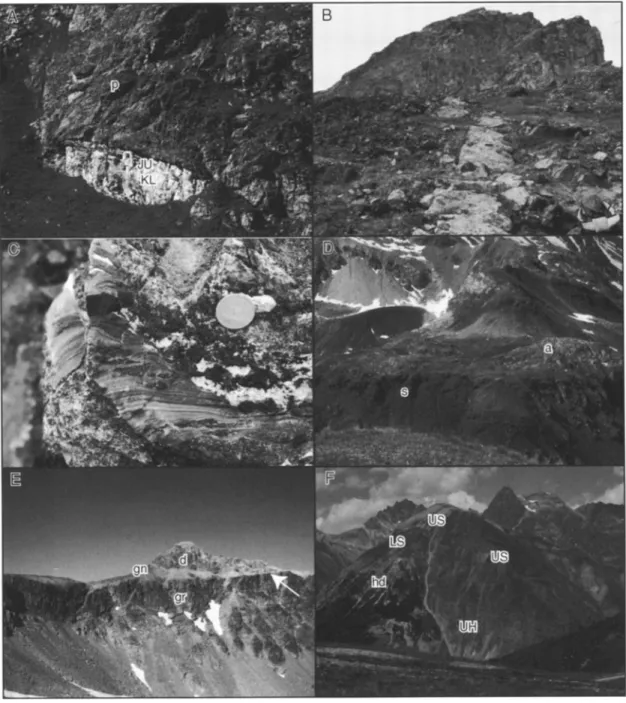
•;•;;L:,'•½•5::;..:.-' •"::;•::•.,•:: ,., ,....•;-•-•,•::•?• ...Figure 6. Geometrical relationships between postrift, synrift, and prerift sediments, continental, trm•sitional and oceanic crust, and rift-related faults. (a) Pillow basalt (p), stratigraphically overlain by about 3 m of uppermost Middle to Upper Jurassic radiolarites (JU), and Lower Cretaceous white pelagic limestones (KL). The sequence is overturned. Platta nappe, Val Savriez, Grisons. (b) Undeformed, nonrodingitized basaltic dike cutting across serpentinized peridotites. Serpentinization predates emplacement of the dike (and extrusion of pillow lavas). Platta nappe, Starschagns, Grisons. (c) Pocket in serpentinized peridotite filled by internally deposited sediment. Layers and laminae of serpentinitic arenite with limestone matrix show distinct size- grading and lamination. Together with the radiolari.tes stratigraphically overlying the serpentinites, these internal sediments document exposure of the serpentinites at the seafloor. Coin is 2 cm in diameter. Arosa zone (lateral equivalent of Platta nappe), Totalp, Grisons. (d) Serpentinized peridotite (s), overlain by an extensional allochthon (a) composed of brittlely deformed granite and orthogneiss. The subhorizontal contact between the serpentinites and the allochthon is locally marked by a black fault gouge, clasts of which also occur in synrift debris flow breccias, documenting the Mesozoic age of emplacement of the allochthon. (e) Low-angle detachment fault (arrow) separating Variscan continental basement (Err granite, gr) below from tilted block composed of Variscan gneiss (gn) and prerift sediments (Lower Triassic sandstones and Middle
Triassic dolomites (d), Err nappe, Piz Lavin;:r, Grisons. (f) Jurassic high-angle fault separating Upper Triassic
prerift sediments (Norian Hauptdolomit Formation (hd) to the left) from Liassic synrift sediments (Allg•iu Formation, upper Hettangian (UH), lower Sinemurian (LS), upper Sinemurian (US)) to the right. Synrift sediments are hemipelagic spiculitic limestones with intercalations of thick debris flow breccias and proximal turbidites. The prerift sediments to the left are unconformably overlain by lower Sinemurian breccias, and the fault is sealed by upper Sinemurian basinal limestones. II Motto, Sond:io Province, Italy.
MANATSCHAL
AND BERNOULLI:
GALICIA
AND ADRIA MARGINS
1109
Fault geometry
and basin
fill architecture
of the south
Alpine
basins are conspicuously
similar to that observed in
reflection
seismic
profiles
across
the Jeanne
d'Arc basin
of the
Newfoundland
margin (Figure 7) [Keen et al., 1987]. This
basin is situated on the conjugate margin of the Iberian
Atlantic; however, it evolved during early rifting when the
evolution of the future margins was still symmetrical (see
below).
In the Austroalpine proximal margin, exceptional
exposures
in the Ortler nappe
allowed
scientists
to identify
several
high-angle
normal faults [Froitzheim,
1988; Conti et
al., 1994]. Here the different
subbasins
appear
to be smaller
than those in the southern Alps; spacing between the faults is
only of the order
of 5 - 10 km, and the thickness
of the basin
fill is less than 1 km. At I1 Motto (Figures 5 and 6f), one of
these
high-angle
normal
faults
separates
prerift
Upper
Triassic
dolomites to the west from lower Liassic fault scarp-derived
breccias interbedded with turbidites and hemipelagic
sediments to the east. The synrift sediments show thinning
and fining upward
cycles
and are overlain
by pelagic
and
hemipelagic
sediments
of late Sinemurian
age which also
overlie the dolomites to the west sealing the fault. The
reconstruction of the original fault geometry shows that near the surface the fault was dipping 60 ø - 70 ø toward the east.
In contrast to the basins in the proximal margin, the basins in the distal margin are less well preserved. The reconstruction of the basin geometry is mainly based on the
depositional
geometries
of the synrift sediments
which show
that these basins were smaller [Finger et al., 1982]. Their
spacing
was of the order of 3 - 5 km, and the sedimentary
fill
was only a few hundred meters thick. In many places, the synrift sediments overlie directly low-angle detachment faults exposed at the seafloor.
Rifting along the distal part of the margin (Err domain)
initiated later than in the proximal margin, during the late
Liassic (Toarcian)
or earliest
Middle Jurassic:
middle Liassic
hemipelagic cherty limestones (Agnelli Formation) show a
constant thickness across the entire distal margin and no
indication of synsedimentary faulting. The limestones terminate with a typical submarine hard ground and are unconformably overlain by deep-water clastics, interbedded with hemipelagic marls and between 200 and 450 m thick (Figure 5, Saluver Formation) [Finger et al., 1982]. The
formation includes siliciclastic turbidites, often with a
reddish matrix and coarse, unsorted, polygenic breccias with variable amounts of matrix and clasts predominantly derived
from the basement. The frequent occurrence of clasts of alkali
granite, characteristic
for the Bernina nappe [Spillmann
and
Biichi, 1993], indicates uplift and subaerial exposure of parts of the Bernina domain contemporaneous with downfaulting of the Err domain. The age of the Saluver Formation is weakly constrained; it is younger than the lower Pliensbachian hard ground along the top of the Agnelli Formation (H. Furrer,
personal
communication,
1997) and older than the overlying
upper Middle Jurassic Radiolarite Formation [Baumgartner, 1987]; therefore a late Liassic (Toarcian) to early Middle Jurassic age may be assumed for these synrift sediments. Contemporaneous with initial faulting in the distal margin, a
second
pulse of gravity flow sedimentation
is noted in the
distal part of the proximal margin (eastern Bernina-Ela)
[Eberli, 1988]. This late Liassic event may be associated with the uplift of the Bernina domain reactivating the fault(s) bounding the adjacent basin to the east. However, in contrast to the siliciclastic gravity flow deposits of the Saluver Formation, fault scarp derived breccias and turbidites of the
proximal margins yield no basement clasts but only
fragments of Triassic dolomites and limestones and penecontemporaneously displaced carbonate material.
3.2.3. Similarities in the synrift evolution of the two
margins. Although
the age of rifting is different in the two
margins, there are remarkable analogies in their evolution. The duration of rifting along both margins is of the order of some 40 Myr. Along both margins, rifting shifted to the distal
margin about 20 Myr before onset of seafloor spreading,
reflected by the younging of the synrift and postrift
sediments toward the ocean. A similar sedimentary evolution
is suggested
by comparable
facies and thickness
variations
across the margins, in turn suggesting
a similar isostatic
response
to extension.
Another
similarity
is the change
of the
basin architecture from large-scale and overall symmetrical in
the proximal margin to small-scale
and asymmetrical
in the
distal margin.
3.3. Transitional and Oceanic Crust
3.3.1. Transitional and oceanic crust along the Galicia
margin. A major result of ODP Leg 103 was the discovery of serpentinized mantle rocks exposed at the seafloor. The serpentinized mantle rocks occur along a 10 - 12 km wide segmented "ridge" [cf. Boillot et al., 1987] which can be
followed over 125 km parallel to the continent-ocean boundary. Basalts and gabbros occur only locally on the ridge itself [Boillot et al., 1995b] but are more common along its western slope. Refraction seismic and magnetic data suggest the existence of a thin oceanic crust west of the peridotite ridge [Whitmarsh et al., 1993]. On the eastern flank of the ridge the Galinaute II submersible cruise [Boillot et al., 1995b] sampled a breccia with fragments of ultramafic, mafic, and continent-derived rocks. This breccia has been interpreted by Boillot et al. [1995b] as a tectonic breccia formed during Early Cretaceous rifting along a low-angle, brittle detachment fault.
The seismic velocity structure and magnetic anomalies of the peridotite ridge are distinctly different from those expected from either a true oceanic crust or a thinned continental crust [e.g., Discovery 215 Working Group, 1998]. Therefore this type of crust has been termed transitional [Whitmarsh and Sawyer, 1996]. The transitional crust is assumed to consist mainly of serpentinized peridotites separating thinned continental crust to the east from true ocean crust to the west. The serpentinization front is assumed to lie, on the basis of the seismic velocity structure, at 5 - 6 km below the seafloor [Boillot et al., 1988] and to coincide with the Moho reflection observed in seismic profiles.
Samples collected by dredging, by drilling, and from submersibles show that the transitional crfist consists of serpentinized plagioclase-bearing harzburgite and lherzolite [Beslier et al., 1990], locally cut by rare plagioclase-rich veins and dioritic intrusions. The petrological and structural evolution of the serpentinized peridotite documents the following history of exhumation: (1) partial melting of the peridotite at temperatures of 1250 ø - 970øC, (2) formation of
mylonites at temperatures decreasing from about 1000 ø to
850øC; (3) crystallization of pargasite (900 ø - 800øC) and other amphiboles under static conditions (750øC), (4) beginning hydrothermal alteration, (5) serpentinization (<300øC), and (6) brittle fracturing and filling of the fractures with serpentinite fragments and calcite cements (Figure 8), [cf.
Evans and Girardeau, 1988; Girardeau et al., 1988; Beslier
et al., 1990).
Foliated dikes of dioritic composition cutting across the serpentinites include brown amphibole overgrowing a high-
1110 MANATSCHAL AND BERNOULLI: GALICIA AND ADRIA MARGINS • O o -•
•E
,
• , E (o05) oW!.l. w I ... ... c (oos) OWLL 990 L -• Z90L -• 006 ---*890 L -•
690 L -•MANATSCHAL AND BERNOULLI: GALICIA AND ADRIA MARGINS 1111
a P (kbar)
lOt
Rifting:
-210-160
onset ofMa
rifting 8_ ky 270 Ma
b
P (kbar) Rifling:- 210-160 Ma 10_ onset of riflingand
•
I 600 c P (kbar) Rifting:-140-114 Ma lO 8 ky 6 4 I I I I I I I • 200 400 600 800 T ('C) 200 400 800 T (øC) 200 400 600 onset of rifting si i 800 T ('C) Figure 8. P-T-t paths of lower crustal and mantle rocks tYom the Adriatic and Galicia margins: (a) Malenco (granulites), (b) Ivrea (granulites), and (c) Galicia (peridotite). The examples of the Malenco and Ivreagranulite terrains have been compiled by Hermann [1997]. For locations, see Figures 3 and 4, and for details
and further references, see Mfintener et al. [1999] for Malenco and Handy and Zingg [1991, and references therein] for Ivrea. For the Galicia margin, see Boillot et al. [1995a, and references therein].
temperature
foliation.
The 39Ar/40Ar
dating
of amphiboles
from one of these dikes yielded a well-constrained plateau age oI' 122+0.6 Ma [Fdraud et al., 1988]. This age is compatible with the U-Pb ages of 13 different zircon fractions from a gabbro and a sheared chlorite-bearing schist froin the same locality, which yielded an identical age of 122+0.3 Ma [Schfirer et al., 1995]. Thus dike and gabbro emplacement predates the breakup, generally assumed to occur at 114 Ma along the Galicia margin [Boillot et al., 1988], indicating the
occurrence of synrift magmatic activity.
Basalts collected during submersible dives along the northwestern Galicia margin and from the peridotite ridge show a tholeiitic signature free of continental contamination [Kornprobst et al., 1988; Malod et al., 1993; Charpentier et al., 1998]. Rare earth element patterns and isotopic ratios (Nd and Sr) grade from gently enriched to moderately depleted.
Two basalt
samples
from the oceanward
slope
of the peridotite
•'•dge
yielde•i
•n 39•r/41TAr
age
of 100+5
Ma [Malod
et al.,
1993], indicating that the emplacement of these basalts postdated the gabbro intrusion and the breakup which
occurred at 114 Ma [Boillot et al., 1988].
3.3.2. Transitional ocean floor sequences of the Liguria- Piemonte ocean in Grisons. Relatively complete ocean floor
sequences of the Liguria-Piemonte ocean are preserved in the Platta nappe in Grisons. The weak Alpine metamorphic overprint and the strongly localized Alpine deformation led to the preservation of primary contacts between ultramafic
and mafic rocks and postrift sediments.
The ultramafic rocks are serpentinized harzburgites and
lherzolites. Pyroxenite layers occur within the serpentinites and are commonly subparallel to the locally preserved spinel foliation. In high-temperature mylonitic shear zones, pyroxene shows crystal plastic deformation indicative of temperatures above 700øC, whereas low-temperature
mylonitic shear zones are composed of strongly foliated
serpentinite (< 350øC) and are usually overprinted by hydrothermal alteration and late brittle deformation. Both types of shear zones are scarce, showing that deformation was localized. Fragments of serpentinite mylonites occur as clasts
in cataclastically deformed serpentinite and document progressive deformation under decreasing temperatures.
Replacement of serpentine minerals by calcite occurred under
still lower temperatures.
Tectonosedimentary breccias, so-called ophicalcites,
typically occur along the top of the serpentinites. They
include serpentinite clasts embedded in a fine-grained.
microsparitic.
typically
red-stained
calcite
matrix or white
sparry. dalcite often preserving typical cement fabrics [Bernoulli and Weissert, 1985]. The fabric of these breccias varies considerably from serpentinite host rock with fractures filled by red limestone and/or white sparry calcite (Figure 6c), to clast-supported breccias with in situ fragmented serpentinite clasts (ophicalcites I of Lemoine et al. [1987]), to coarse, unsorted, matrix-supported breccias with fragments of serpentinite, gabbro, and continent-derived basement rocks and prerift sediments (ophicalcites II of Lemoine et al. [1987]). Clasts of basalts are conspicuously absent in these i•reccias. The amount of matrix within these tc, ctonosedimentary breccias typically increases away from the hostrock and upsection. Geopetal infill of sediment into crevasses and pockets of the mantle rocks indicates that these rocks were exposed at the seafloor (Figure 6c) [Bernoulli andWeisseft, 1985]. Ophicalcites I are very similar to tectonosedimentary breccias overlying exhumed serpentinites at Site 1070 (Iberia Abyssal Plain) [cf. Whitmarsh et al. 1998].
Gabbro bodies occur but are not very common. Part of them are isotropic and show intrusive contacts with the enclosing serpentinites, whereas others have been deformed under high- temperature conditions. Gabbros are also found as clasts in tectonosedimentary breccias and pillow breccias. Two gabbro samples from an intrusion in the Platta nappe were dated by U-Pb on zircons and yielded an age of 161+1 Ma [Destours et al., 1999]. This age is almost identical with ages obtained from other gabbros from the Liguria-Piemonte ocean [Bill et al., 1997; Rubatto et al., 1998] and is close to the age of the oldest postrift sediments overlying the serpentinites (late Middle Jurassic) [Baumgartner, 1987].
Basaltic dikes cut across the serpentinites (Figure 6b), and the gabbros and basaltic flows overlie stratigraphically the tectonosedimentary breccias and serpentinized mantle rock (Figure 5), however, they do not occur as clasts in tectonosedimentary breccias. The basalts are obviously the youngest rocks within the ultramafic-mafic sequence, and their extrusion post-dated mantle exposure at the seafloor. Thickness and volume of the basalts increase oceanward over
10 - 20 km from zero to a few hundred of meters, whereas the