GeoFocus
volume 30
Martin BOCHUD
Tectonics of the Eastern Greater Caucasus
in Azerbaijan
DEPARTMENT OF GEOSCIENCES – EARTH SCIENCES
UNIVERSITY OF FRIBOURG (SWITZERLAND)
Tectonics of the Eastern Greater Caucasus in
Azerbaijan
THESIS
Presented at the Faculty of Sciences of the University of Fribourg (Switzerland) in
consideration for the award of the academic grade of Doctor rerum naturalium
by
Martin Bochud
from
Hauterive (Fribourg), Switzerland
2.4.5. Upper Cretaceous and Paleogene opening of rifted basins _______________________ 30 2.4.6. Paleocene-Eocene Rift System ___________ 32 2.4.7. Oligoc. to present Caucasus orogeny ______ 32
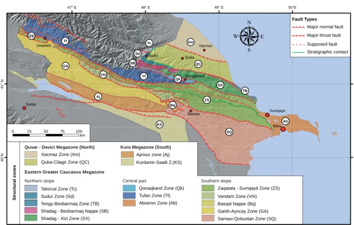
2.5. STRUCTURAL SETTING ___________________ 33 2.5.1. Qusar-Davaci Mega Zone ______________ 33 2.5.2. The Eastern Greater Caucasus Mega Zone _ 33 2.5.3. The Kura Mega Zone __________________ 35
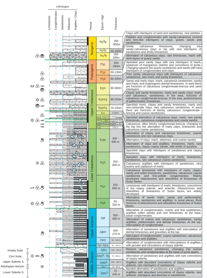
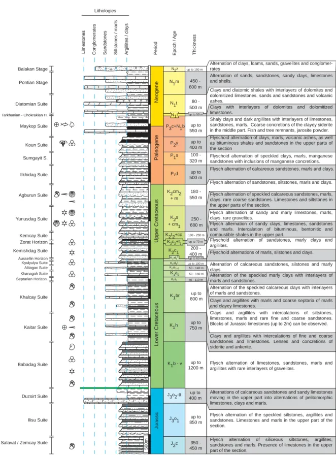
2.6. LITHOSTRATIGRAPHICAL SETTINGS ___________ 35 2.6.1. General context_______________________ 35 2.6.2. Jurassic Period (J) _____________________ 35 2.6.3. Cretaceous (K) _______________________ 44 2.6.4. Paleogene (P) ________________________ 47 2.6.5. Neogene (N) _________________________ 48 2.6.6. Quaternary (Q) _______________________ 49
3 - STRUCTURAL GEOLOGY,STRESS AND STRAIN ACROSS THE EGC (AZERBAIJAN)
3.1. INTRODUCTION ________________________ 53
3.2. GEOLOGY OF THE EGC __________________ 53
3.3. EGC STRUCT.ZONES AND THEIR STRUCT. _____ 54 3.3.1. Tahircal Zone ________________________ 55 3.3.2. Sudur and Tengy Besbarmaq zones _______ 58 3.3.3. Sahdag – Besbarmaq Nappe _____________ 58 3.3.4. Sahdag-Xizi Zone _____________________ 59 3.3.5. Qonaqkand Zone _____________________ 61 3.3.6. Tufan Zone __________________________ 61 3.3.7. Zaqatala – Sumqayit Zone ______________ 62 3.3.8. Vandam Zone ________________________ 62 3.3.9. Basqal Nappe ________________________ 62 3.3.10. Ganih-Ayricay Zone __________________ 62 3.3.11. Samaxi-Qobustan Zone _______________ 63 3.3.12. Abseron Zone _______________________ 63 3.3.13. Ajinour Zone (Aj) – Kura MZ __________ 63 3.3.14. Kurdamir-Saatli Zone – Kura MZ _______ 63
3.4. FAULTS ANALYSIS ______________________ 64 3.4.1. Fault orientation interpretation ___________ 64
3.5. STRESSES ANALYSIS _____________________ 71 3.5.1. Method for stress analysis ______________ 71 3.5.2. Results and interpretation _______________ 75
CONTENTS ________________________________ 1 ABSTRACT ________________________________ 5 RÉSUMÉ __________________________________ 7 ACKNOWLEDGMENTS ________________________ 9
1 - I
NTRODUCTION 1.1. OBJECTIVES___________________________ 111.2. PROJECT AND COLLABORATIONS ____________ 11
1.3. FIELDTRIPS ___________________________ 12
1.4. GEOMORPH.FEATURES OF THE CAUCASUS _____ 14 1.4.1. Summits and topography _______________ 14 1.4.2. Climate _____________________________ 14 1.4.3. G laciers _____________________________ 15 1.4.4. H ydrography _________________________ 15 1.4.5. Hominids records of Dmanisi (Georgia)
and C aucasus ________________________ 17
1.5. GEOLOGY OF THE GREATER CAUCASUS AND ITS SURROUNDING AREAS _________________ 18 1.5.1. Earthquakes _________________________ 19 1.5.2. Uplift and shortening __________________ 21 1.5.3. Volcanoes and magmatism ______________ 21 1.5.4. M ud Volcanoes _______________________ 21
1.5.5. Oil and gas fi eld ______________________ 23
2 – G
EOMORPHOLOGY ANDG
EOLOGYOF THE
EGC
OFA
ZERBAIJAN2.1. INTRODUCTION ________________________ 25
2.2. GEOGRAPHIC AND GEOMORPH.SETTING _______ 25 2.2.1. Topographic setting ___________________ 25 2.2.2. Climatic setting_______________________ 26 2.2.3. Hydrographic setting __________________ 26
2.3. GEODYNAMIC SETTINGS __________________ 28
2.4. PALEOGEOGRAPHIC EVOLUTION _____________ 28 2.4.1. Late Triassic – Lower Juras. compression __ 29 2.4.2. Lower and Middle Jurassic rifting and
compression _________________________ 29 2.4.3. Upper Jurassic rift systems and
compression event ____________________ 30 2.4.4. Lower Cretaceous extension ____________ 30
2 -
Contents5.4. UPLIFT/SUBSIDENCE AND TECTONICS
VERSUS TOPOGRAPHY ___________________ 139 5.4.1. Subsidence studies ___________________ 139 5.4.2. Uplift-Exhumation ___________________ 139 5.4.3. Palaeogeography ____________________ 141 5.4.4. Tectonic G eomorphology ______________ 145 5.4.5. Topography and Thrusts _______________ 145
5.5. DISCUSSION-CONCLUSIONS _______________ 147 5.5.1. Acknowledgments ___________________ 149
6 - G
EOGRAPHICALI
NFORMATIONS
YSTEMFOR THE
EGC
6.1. FIELDWORK WITH G IS __________________ 151
6.1.1. GIS Preparation of fi eldwork ___________ 151
6.1.2. Fieldwork __________________________ 152 6.1.3. Data validation and analysis ____________ 152 6.1.4. Publication _________________________ 152
6.2. SOFTWARE AND HARDWARE ______________ 152 6.2.1. GIS softwares _______________________ 152
6.2.2. GPS and fi eld computer _______________ 153
6.3. ARCHITECTURE OF GEODATABASE __________ 153 6.3.1. M easurements _______________________ 153 6.3.2. P ictures ____________________________ 154 6.3.3. Samples ___________________________ 154
6.4. MAPS AND VECTOR DATA ________________ 156
6.5. GIS APPLICATIONS IN EGC ______________ 156 6.5.1. Geological maps _____________________ 156 6.5.2. Digital elevation models _______________ 156 6.5.3. 3D model of the Jurassic Basement ______ 156 6.5.4. Topographical and slope analyses _______ 156 6.5.5. Accurate topographic measures _________ 160
6.5.6. River topographical profi les ____________ 160
6.5.7. River drainage patterns ________________ 160
6.6. CONCLUSION _________________________ 160
7 - C
ONCLUSION7.1. BUILDING OF THE EGC _________________ 163
7.2. EGC STRUCTURAL MODEL ______________ 164
7.3. EGC SURFACE UPLIFT __________________ 164
7.4. THERMAL EVOLUTION___________________ 164
7.5. STRUCTURE IN THE GREATER CAUCASUS _____ 165 APPENDIX 1 - PT STRESS ANALYSES ______________ 169 APPENDIX 2 - IC AND OM ANALYSES ____________ 173
A2.1. Results of IC analyses made in 2008 at the CSJF from the Total company
in Pau (France) _________________________ 173 A2.2. Results of IC analyses made in 2007
at the Un. of Neuchâtel ___________________ 174 A2.3. Organic Matter analysis __________________ 175 A2.4. Results of OM analyses made in 2008
at the CSJF from the Total company
in Pau (France) _________________________ 177
3.6. SYNTHESIS AND CONCLUSION ______________ 75 3.6.1. EGC Structural Model _________________ 75 3.6.2. EGC evolution _______________________ 78 3.6.3. Geodynamics of the EGC _______________ 79
PLATE 3.1: STRUCT.OF TAHIRCAL VALLEY _______ 82
PLATE 3.2: STRUCT.OF SUDUR AREA ___________ 84
PLATE 3.3: STRUCT.OF SAHDAG MT.
AND QIZILQAYA MT. ______________ 86
PLATE 3.4: STRUCT.OF TUFAN ZONE - BAZARDUZU
AREA _________________________ 88
PLATE 3.5: STRUCT.OF TUFAN Z. - QUDIYALCAY
VALLEY _______________________ 90
PLATE 3.6: STRUCT.OF LOWER CEK VALLEY _____ 92
PLATE 3.7: STRUCT.OF UPPER CEK VALLEY ______ 94
PLATE 3.8: STRUCT.OF LOWER RUK VALLEY _____ 96
PLATE 3.9: STRUCT.OF UPPER RUK VALLEY ______ 98
PLATE 3.10: STRUCT.OF BABADAG MT.
AND BUROVDAL VILLAGE AREA _____ 100
PLATE 3.11: STRUCT.OF LAHIC VILLAGE AREA ___ 102
PLATE 3.12: STRUCT.OF GIRDIMANCAY RIVER
AND SAMAXI TOWN AREA _________ 104
PLATE 3.13: STRUCT.OF QARAMARYAM HILLS
AND AGDAS TOWN AREA __________ 106
4 - B
URIAL AND EXHUMATION:
FISSIONTRACKS
,
ILLITE CRYSTALLINITY ANDSUBSIDENCE CURVE STUDY IN THE
EGC
4.1. INTRODUCTION _______________________ 110
4.2. GEOLOGY AND EVOLUTION OF THE EGC _____ 110 4.2.1. Tectonic evolution of the EGC __________ 112 4.2.2. Surface uplift rates of the EGC _________ 114
4.3. METHODS AND DATA ___________________ 114 4.3.1. Apatite Fission-Tracks analysis _________ 114 4.3.2. IC index and mineral content analysis ____ 117 4.3.3. Subsidence curves ___________________ 119
4.4. FISSION-TRACKS RESULTS AND INTERPRETATION 121 4.4.1. Apatite Fission-Track age distribution ____ 121 4.4.2. Pit diameters (Dpar) __________________ 123
4.4.3. Confi ned track length and t-T model. _____ 123
4.4.4. Interpretation _______________________ 123
4.5. IC RESULTS AND INTERPRETATION __________ 125 4.5.1. Interpretation _______________________ 126
4.6. SUBSIDENCE CURVES ANALYSIS
AND INTERPRETATION ___________________ 127 4.6.1. Interpretation _______________________ 130
4.7. GENERAL DISCUSSION AND CONCLUSION _____ 130
5 - CENOZOIC-RECENT TECTONICS AND UPLIFT IN THE GREATER CAUCASUS:A PERSPECTIVE FROM AZERBAIJAN
5.1. INTRODUCTION _______________________ 134
5.2. REGION. TECTONICS AND GEODYNAMICS _____ 134
5.3. ACTIVE TECTONICS, CONVERGENCE AND UPLIFT 138 5.3.1. Earthquakes and active faults ___________ 138 5.3.2. Convergence and Uplift _______________ 139
A2.5. Results of OM analyses made in 2007
at the Un. of Neuchâtel ___________________ 178 APPENDIX 3 – GEOMORPH.ANALYSES ____________ 179
A3.1. Locations of the 3 topographic sections
of the appendix A3.2 _____________________ 179
A3.2. Topogr. profi les across the EGC ____________ 180
A3.3. 5 topogr. profi les across Qaramaryan
hills (southern slope of the EGC) ___________ 181 A3.4. Determining the topogr. and
Drainage pattern of rivers _________________ 182
A3.5. River topographic profi les of the EGC
northern slope __________________________ 183
A3.6. River topographic profi les of the EGC
southern slope __________________________ 184 A3.7. Drainage pattern of Qusarcay and
Qudiyalcay rivers (EGC northern slope) _____ 185 A3.8. Drainage pattern of Girdimancay
River (EGC southern slope) _______________ 186 A3.9. Stream segments length statistics of Qusarcay, Qudiyalcay and Girdimancay rivers _________ 187 A3.10. Stream segm. number statistics of Qusarcay, Qudiyalcay and Girdimancay rivers ________ 187
REFERENCES _______________________________ 189
CURRICULUM VITAE _________________________ 199
rates of 0.77 mm/yr since the Pliocene (~2.6 Myr) and 0.31 mm/yr since the Sarmatian (~11.6 Myr). Based on Apatite fi ssion-track, Illite Crystallinity and sub-sidence studies, we determine that a fast exhumation acted on the northern area (Tahircal Zone) since the Late Miocene whereas the central area (Tufan Zone) was affected by slower uplift rates but during a longer period (since Eocene-Oligocene). This long term up-lift built the highest relief of the EGC. These upup-lift rates of the EGC cannot be compared with the rate of 10-12 mm/yr since the Pliocene of the central Greater Caucasus in Georgia and Russia.
Several events in the EGC allow defi ning more than six main compressive phases since the Middle Jurassic. The fi rst occurred before Callovian times and is expressed by Callovian deposits that unconform-ably lie on folded Aalenian deposits. The second is expressed by Berriasian conglomerates that transgres-sively cover tilted Kimmeridgian deposits. The third corresponds to an erosional event of a paleo-valley in the Sahdag-Besbarmaq Nappe and on the underly-ing Sahdag-Xizi Zone that is subsequently fi lled by Upper Cretaceous to Pliocene sediments. The fourth compressive event occurred at the end of the Upper Cretaceous and beginning of the Paleocene and is ex-pressed by Paleocene sediments that transgressively cover deposits from the Middle Jurassic to the Creta-ceous in the northern area. The fi fth event corresponds to the creation of foreland basins during the Eocene and Oligocene that resulted from the building of the Greater Caucasus. The last event corresponds to the major uplift that started during Middle-Late Miocene and is based on marine sediments at high altitude.
In terms of thermal history, we observe only a weak schistosity that develops in the central part and corre-sponds to a very low-grade metamorphism in favorable lithologies. Apatite fi ssion-track and illite crystallinity analyses show an increase of the metamorphism from the northern orogenic front to its central part. They The Greater Caucasus is Europe’s largest and
high-est mountain belt and results from the inversion of the Mesozoic Greater Caucasus back-arc-type basin due to the collision of Arabia and Eurasia. The oro-genic processes that led to the present mountain chain started in early Tertiary, accelerated during the Plio-Pleistocene, and are still active nowadays.
The Eastern Greater Caucasus (EGC) is located to the north of Azerbaijan. It corresponds to a doubly verging fold-and-thrust belt, with a pro- and a retro wedge actively propagating into the foreland sedimen-tary basins of the Kura to the south and the Terek to the north. The area is known since the antiquity for its hy-drocarbon resources and its mud volcanoes. This par-ticular context added to the high summits of its central area (Bazarduzu Mt. reaches 4466 m) and the proxim-ity with the deep South Caspian intracontinental basin make it an unique place to investigate geodynamics of basin formation and of the orogenic structures.
The aim of this thesis is fi rst to describe the geology and the evolution of the Eastern Greater Caucasus. Sec-ondly we detailed structural and geomorphological fea-tures of selected areas to develop a structural model of the EGC that we export to the Greater Caucasus. Finally we tested methods like Apatite Fission Tracks (AFT), Illite Crystallinity (IC) and subsidence curves to characterize the thermal evolution and the subsidence/uplift of the area.
The structural features of the EGC result from an average NNE-SSW compressive stress. Folds have axis that slightly dip to the ESE. The EGC is cut by thrusts dipping to the NNE and SSW. They are respec-tively located to the S and to the N with a transition in the central part. Finally, the recent anticaucasian strike-slip fault system led to the present valley geo-morphology and orientation.
Based on marine sediments at altitudes between 2000 m and 3550 m, we respectively determine uplift
6
- Abstractshow also a decrease of the metamorphism southeast-wards along the main EGC crest. AFT time-temperature models and subsidence curves show a fast burial during the Middle-Upper Jurassic and they all fi nish by an ex-humation starting, depending on the area, from the be-ginning to the end of Miocene. The north is affected by an exhumation-burial period starting during the Upper Cretaceous and fi nishing in the Middle Miocene.
Combining our structural and geomorphological study in the EGC with literature and GIS studies on the other regions of the Greater Caucasus, we expand ourfi ndings to the whole Greater Caucasus. The Main Caucasus Thrust (MCT) is a major thrust that crosses the whole Greater Caucasus from west to east. The zone of highest topography of the Greater Caucasus
is bound to the south by the MCT which shows im-portant top to the south movement and to the north by south dipping thrusts with top to the north movement. We associate this north faults to a N-verging back-thrusting system linked to a thrust ramp system to the south corresponding to the MCT. The migration of the MCT to the south during Tertiary is responsible for the formation of succesive foreland basins separated by clear changes in topography, deviation of rivers and water gaps. The geodynamic behaviour between the east and west Greater Caucasus area is not identical. This is mainly due to several factors such as the E to W decreasing plate convergence rate; the basement that outcrops only in the west; and the recent volcan-ism and magmatic activity that affected the central and western part of the Greater Caucasus.
Keywords: Greater Caucasus, Azerbaijan, structural, stress, Apatite Fission Track, Illite Crystallinity, subsidence, geomorphology, GIS.
nombreux chevauchements dirigés vers le NNE et le SSW. Ils sont respectivement situés au nord et au sud du Grand Caucase Oriental avec une transition dans la région centrale.
Basé sur des sédiments marins trouvés à des altitudes de 2000 m et de 3550 m, nous avons respectivement déterminé des taux de soulèvement de surface de 0.77 mm/a depuis le Pliocène (~2.6 Ma) et de 0.31 mm/a depuis le Sarmatien (~11.6 Ma). Ces soulèvements ne sont pas comparables à ceux obtenus dans la partie centrale du Grand Caucase (Géorgie, Russie) qui atteignent des vitesses de 10 à 12 mm/a. Les traces de fi ssion dans l’apatite, nous ont permis de déterminer que la partie centrale (Zone de Tufan) a subit des vitesses d’exhumation plus faibles mais durant une plus longue période (depuis l’Oligocène-Miocène Inf.) que la partie nord (Zone de Tahircal) où la dernière phase d’exhumation a commencé au Miocene Supérieur.
Différents événements dans le Grand Caucase Oriental ont permis de défi nir six phases compressives. La première s’est déroulée avant le Callovien (Jurassique Moyen). Des sédiments Callovien sont en contact transgressif sur des sédiments Aalénien plissés. La deuxième phase est déterminée par le dépôt de conglomérats Berriasien sur des dépôts marins Kimméridgien fortement inclinés. La troisième phase correspond à l’érosion d’une paléo-vallée à travers la Nappe du Sahdag-Besbarmaq et une partie de la zone de Sahdag-Xizi. Cette paléo-vallée a ensuite été comblée par des sédiments marins allant du Crétacé Supérieur au Pliocène. La quatrième phase s’est déroulée à la fi n du Crétacé Supérieur et s’exprime au nord du Grand Caucase Oriental par des sédiments Paléocène transgressifs sur des dépôts marins allant du Jurassique Moyen au Crétacé. La cinquième phase est directement liée au début de la formation du Grand Caucase à l’Eocène-Oligocène où l’on voit se créer des bassins d’avant-pays qui sont remplis Le Grand Caucase est la plus haute et la plus
longue chaîne de montagne en Europe. Elle est le résultat de l’inversion suite à la collision de la plaque arabique et eurasienne d’un ancien bassin d’arrière-arc mésozoïque, le « Greater Caucasus Basin ». La formation de l’actuel Grand Caucase a commencé au début du Tertiaire avec une accélération des mouvements au Pliocène-Pléistocène. Elle est encore active actuellement.
Le Grand Caucase Oriental (EGC : « Eastern Greater Caucasus ») est situé au nord de l’Azerbaijan. Il correspond à une chaîne de chevauchements et de plis à double vergences avec une propagation vers le sud dans le bassin d’avant-pays du Kura et vers le nord dans le bassin d’arrière-pays du Terek. La région est connue depuis l’Antiquité pour ses ressources en hydrocarbures et ses volcans de boue. Ce contexte particulier, ces hauts sommets de la partie centrale (le sommet du Bazarduzu atteint 4466 m d’altitude) et le proche bassin sud caspien rendent cette zone intéressante pour des études sur l’évolution et la géodynamique.
Le but de ce doctorat est dans un premier temps de décrire la géologie et l’évolution du Grand Caucase Orientale. Deuxièmement, des études structurales et géomorphologiques sur des zones sélectionnées ont été réalisées afi n de défi nir un modèle structural de la région et de l’étendre ensuite à la totalité du Grand Caucase. Finalement, nous avons testé différentes méthodes comme les traces de fi ssion dans l’apatite, la cristallinité de l’illite et les courbes de subsidence qui permettent entre autres de caractériser le comportement thermique et l’exhumation de la région.
Les structures géologiques du Grand Caucase Oriental sont le résultat d’une contrainte compressive de direction NNE-SSW. Les plis résultants ont un plongement axial de quelques degrés vers l’ESE. Le Grand Caucase Oriental est également découpé par de
8 -
Résumépar des sédiments venant de l’érosion de la nouvelle chaîne de montagne. La dernière phase correspond au soulèvement principal de la chaîne qui commence durant le Miocène et est basée sur des sédiments marins trouvés en altitude.
Au niveau de l’histoire thermique, nous avons observé une faible schistosité dans la partie centrale du Grand Caucase Oriental. Elle correspond à un métamorphisme de très faible intensité dans des lithologies favorables. Les analyses de traces de fi ssion dans l’apatite (AFT) et de l’indice de cristallinité montrent une augmentation du métamorphisme en partant du front orogénique nord de la chaîne vers la partie centrale. Elles montrent également une diminution du métamorphisme en partant de la partie centrale vers l’ESE en suivant la crête principale de la chaîne. Les modèles temps-températures des AFT et les courbes de subsidences montrent toute un enfouissement rapide au Jurassique Moyen-Supérieur et elles se terminent par une rapide exhumation au Miocene-Pliocene. La partie nord est caractérisée par un événement intermédiaire d’exhumation-enfouissement qui commence au Crétacé Supérieur et se termine au Miocene Moyen.
En combinant les études structurales et géomorphologiques dans le Grand Caucase Oriental avec la littérature et des études SIG sur d’autres régions du Grand Caucase, nous avons pu étendre à ce dernier les structures découvertes dans la partie orientale. Le « Main Caucasus Thrust » (MCT ou chevauchement principal du Caucase) est un chevauchement qui coupe d’ouest en est la chaîne de montagne. La zone topographique élevée du Grand Caucase est limitée au sud par le MCT qui montre un déplacement important vers le sud et au nord par des failles retro-chevauchantes vers le nord. Ces failles sont liées à un système de rampe vers le sud dont le MCT est la composante principale. La migration de le MCT vers le sud pendant le Tertiaire est responsable de la formation successive de bassins d’avant pays caractérisés par des hauts topographiques, des rivières déviées et des vallées asséchées. Le comportement géodynamique entre l’est et l’ouest du Grand Caucase n’est pas identique. C’est principalement dû à différents facteurs comme la diminution de la convergence de plaque d’est en ouest, l’affl eurement du socle uniquement dans la partie occidentale et le magmatisme et volcanisme récents dans la partie centrale et occidentale.
Mots-clés : Grand Caucase, Azerbaijan, géologie structurale, contraintes, trace de fi ssion, cristallinité de l’illite, subsidence, géomorphologie, systèmes d’information géographique.
zaferi who gave me the opportunity to go in Georgia; Prof. Gamkrelidze (Academy of Sciences, Georgia) and his colleagues Dr. Kakhaber Koiava and Dr. La-sha Shubitidze who organized a very interesting fi eld trip through the Central Caucasus ; Dr. Thierry Adatte (University of Neuchâtel) and the the Centre Scienti-fi que et technique Jean-Féger from the Total Company (Pau, France) who respectively made the illite crys-tallinity and organic matter analyses of our 2006 and 2007 samples.
Communicating with Azeri people would not be possible without the help of our translators: Elmir Akhmedov (2004), Ilkin Kangarli (2005), Tofi g Rash-idov (2006), Emin Isayev and Emil Guliyev (2007) and Elias Mammedov (2008-2009).
I would also thank the azeri families for their hos-pitality with special thanks to Mahir Aliyev and his family (Burovdal, 2004), to Shaxbala Hajibalayev (Tahircal, 2006), to Eyvaz and Saravat Bagirov (Xi-naliq, 2006), to Heydar (Vasa, 2008) and all other per-sons that welcomed us with a tea, a vodka, a meal or gave us a bed.
Special thanks go to my colleagues Eva Matzenau-er, Luc Braillard, Raphaelle Soulignac and Sébastien Morard for the numerous discussions and their moral support.
I owe to all my university colleagues for the nu-merous discussions and activities, for enduring all the “kromoks” and for the very good relationships during the 10 years of my studies at the university : Anna S.-M., André S., Bernard G., Calin T., Christian C., Elias S., Gisela T., Ildiko K.-S., Jean-Marc F., Jean-Pierre B., Jürgen von R., Marino M., Michelle C., Raymond P., Reynald D., Vincent S., Bastien M., Bertrand Y., Cécile B., Corinne S., Christina K., Claudius P., Dam-ien A., Daniel R., Daniel W., Daniela K., David J., Eli-sa R., Florent H., Giordana G., Jonas T., Juanita R.-J., I am very grateful to my thesis director Professor
Jon Mosar for giving me the opportunity to do a thesis like I imagined, for his numerous advices in the fi eld, for his opening to new technologies and for his numer-ous ideas.
I would also specially thank Dr. Talat Kangarli who organized all our fi eld trips in Azerbaijan and shared with us his unvaluable knowledge from the Eastern Greater Caucasus. He also welcomed us in his family always with great kindness and allowed us discover-ing the Azeri culture. I will also thank him to be exam-iner for this thesis.
A special thanks to Prof. Ulrich A. Glasmacher for his interesting and constructive comments in the fi eld but also as examiner of this thesis. He introduced me to the world of the thermochronology and managed to analyse with his team the azeri samples. Thanks also to his team and colleagues including Torben Kissner and Otto Kraft (University of Heidelberg) who partici-pated to the 2007 fi eld trip and prepared and analysed thefi ssion-track samples and Dr. Bertil Maechtle who gave me an introduction to quaternary method in the fi eld
A great thanks to Dr. Marie-Françoise Brunet (CNRS, University Pierre et Marie Curie, Paris, France) who gave me the opportunity to discover the Middle East Geology, to do GIS work with her team andfi nally to give me, as examiner, constructive and detailed comments on this thesis.
This thesis, although it is an individual work, benefi ted from the collaboration of several people in the fi eld : Annick Rast (University of Fribourg) who worked with me in the northern part of the Eastern Greater Caucasus in 2006; Prof. Nigel Mountney (University of Leeds) for his collaboration for the sedimentological part of my work and to receive me for 2 months in his research group ; Dr. Sylvia
10 -
AknowledgmentsKatja von A., Kuno M., Laureline S., Maëlle L., Mario M., Martinus A., Monica C., Naomie V., Noémie S., Norbert R., Pierre V., Richard W., Roy T., Sarah G., Stephan M., Thibault L., Telm B.-A., Tobias I and all the people I forget.
A special thanks to the technical staff including Christophe N., David S., Jean-Paul B., Nicole B. and Patrick D.
I must thank also Softcom Technologies SA that gave me a very interesting work with very fl exible
working hours that allowed me to do my PhD and to continue to work as electronics engineer.
I will also specially thank my family for their care and support throughout the years.
Finally, the most special thanks go to my wife Ana for her love and support and for tolerating my absenc-es from home during innumerous weeks.
The University of Fribourg
The Scientifi c co-operation between Eastern Europe and Switzerland (SCOPES) fi nanced by the Swiss Na-tional Science Foundation
The Middle East Basins Evolution Programme
1 - I
NTRODUCTION
The geology of the Eastern Greater Caucasus has been studied for, at least, the last 150 years. A signifi -cant volume of published literature deals with its evo-lution and much with the oilfi elds that can be found in the surrounding sedimentary basins. Indeed, the oil history almost started here and today Azerbaijan is still one of the world strategic areas in terms of hydrocar-bon resources.
Since the independence of the Azerbaijan in 1991 and the presence of international oil companies, a new impulse on geology started, and numerous studies were published most of them concerning oil explora-tion. The Geological Institute of Azerbaijan (GIA) is very active and numerous projects and collaborations have started. They published in 2008 the new geo-logical map of Azerbaijan at a scale of 1:500’000 (the preceding version at the same scale was published in 1976). However the geodynamic and structural studies concerning the Eastern Greater Caucasus itself did not evolve signifi cantly during the last decades. For the lastfi ve years several groups and international projects have started to study this very interesting area that can clearly give new data to defi ne more precisely the geo-logical evolution of the whole Caspian and Caucasus area.
The main aim of this work is to focus on the geo-dynamics of Eastern Greater Caucasus (EGC) in the north of Azerbaijan. We will discuss uplift rates of the EGC based on analytical methods. Structural styles and geodynamic behaviour of the main structural zones of the EGC will be fi xed and defi ned based on fi eld data collected in remote valleys.
1.1. O
BJECTIVESAfter a general description of the Caucasus area, the fi rst objective is to discuss the geological context of the Eastern Greater Caucasus including the
strati-graphical context, the sedimentary formations through time, the geodynamic context and the geological evo-lution. These descriptions are mostly based on fi eld work.
The second objective is to defi ne the structural zones of the Eastern Greater Caucasus. Field data and observations allow highlighting some typical tectonic features of the EGC. They help constrain the orogenic processes of the EGC and the 3 surrounding sedimen-tary basins: the Terek, the Kura, and the South Caspian basins.
The third objective of this thesis is to investigate the thermal evolution of the area using methods like apatitefi ssion tracks and illite crystallinity. Combined withfi eld observations and subsidence curves, we will try to defi ne the uplift of the area.
The last objective is to generalize these results to the Greater Caucasus combining data like digital el-evation models, earthquakes, uplift maps, and old ter-races. The aim is to defi ne the main faults crossing the Greater Caucasus and to better characterize its geody-namic behaviour.
To help to the realisation of all these objectives, a geodatabase was built. It integrates all the fi eld data, maps, digital elevation models and other information.
1.2. P
ROJECT AND COLLABORATIONSThis thesis is the result of a close collaboration with the Geological Institute of Azerbaijan and it was sup-ported by several international projects. The Eastern Greater Caucasus Project started in 2003 and included different Universities and their scientists.
Fribourg University started its geological studies in the Greater Caucasus with the Middle East Basins
12
- Chapter 1gust 2004 and fi nished the 24th of September. The 7
weeks were divided in two parts: 5 weeks to study the upper part of the Girdimancay River and 2 weeks for afi eldtrip to observe and study major geological out-crops in the northern slope of the EGC. For the second part I was accompanied by Prof. Jon Mosar (Univer-sity of Fribourg, Switzerland), Prof. Nigel Mountney (Keele University, UK), Dr. Talat Kangarli (GIA, Az-erbaij an), Elmir Akhmedov (translator) and our driver Heybat.
The aim of the third expedition from the 4th to the
13th of September 2005 was mainly to detail the
north-ern slope around the northnorth-ern Sahdag – Qizilqaya area. The people involved were Dr. J. Mosar (University of Fribourg, Switzerland), Dr. T. Kangarli (GIA, Azerbai-jan), Ilkin Kangarli (translator), the driver Heybat and myself.
The 2006 expedition was the fi rst for my PhD the-sis but also for the Master thethe-sis of Annick Rast. The main goal was to make a detailed structural study of the Sahdag – Bazarduzu area. The fi eldtrip was from the 4th of August to the 13th of September 2006. During
thefi rst two weeks, I worked with Dr. T. Kangarli and we went in different places around the Eastern Greater Caucasus. After that Prof. J. Mosar, Prof. Ulrich A. Glasmacher (University of Heidelberg, Germany) and Annick Rast came and we worked one week near the Sahdag area. Finally A. Rast and I stayed and stud-ied different places around the Sahdag area during 3 weeks.
In 2007, the main goals of the fi fth fi eldtrip were: an exploration of the Lesser Caucasus near Ganja, taking structural data and more fi ssion-track samples in the central part of the EGC and fi nally looking the possibilities of making quaternary stud-ies. The expedition was from the 21st of August to
the 14th of September 2007. The participants were
Prof. U. A. Glasmacher, Torben Kissner, Otto Kraft and Dr. Bertil Mächtle (University of Heidelberg, Germany), Dr. T. Kangarli and Emin Guliev (GIA, Azerbaijan) and myself. Finally during the second week of October I participated in a 2 days interna-tional conference for young scientists in Baku (8th
and 9th of October 2007) and I also went to measure
the Qaramaryam hills in the southern slope of the EGC and also looked for data and information in the GIA in Baku.
From the 8th to 19th of June 2008, the principal aim
was to measure structural data from the central part of the EGC in both side of the main ridge. Prof. J. Mosar and I went in two valleys on both side of the EGC. We were accompanied by Dr. T. Kangarli and Ilyas Mam-madov (translator).
Evolution Programme (MEBE). It was a 4 years ef-fort (2003- 2006) funded by major oil companies (BP, ENI, PETRONAS, SHELL and TOTAL) and by the French research organizations (INSU-CNRS and UPMC). This multidisciplinary study of the Middle East, spanning the Arabian-Peri-Arabian and Cauca-sian-Caspian areas, was led by E. Barrier (CNRS – Université Pierre et Marie-Curie, Paris, France) and M. Gaetani (University of Milan, Italy). Its focus was the geodynamic evolution of the area. MEBE brought together about 300 scientists from 28 countries, rep-resenting 100 universities and research organiza-tions. The principal MEBE products are an atlas of 14 palaeotectonic maps showing the geodynamic and tectonic evolution of the Middle East between Late Triassic and the Present and a series of four Geologi-cal Society of London Special Publications present-ing the results of the regional MEBE workpresent-ing groups. The four volumes cover the Black Sea – Caucasus, the South Caspian – Central Iran, the Zagros-East Arabian margin and the Levant.
The Scientifi c Cooperation between Eastern Eu-rope and Switzerland program (SCOPES) founded by the Swiss National Science Foundation (SNSF) and the Swiss Agency for development and Cooperation (SDC) supported the next project of the University in this area. The 3 years project named “The Eastern Greater Caucasus: geodynamics of an active moun-tain belt at the cross road of Europe, Middle-East and Asia”, was proposed by Prof. Jon Mosar (University of Fribourg, Switzerland) and Dr. Talat Kangarli (Ge-ological Institute of Azerbaijan). It allowed to create an effective infrastructure for scientifi c studies in the Eastern Greater Caucasus and to found students in the Geological Institute of Azerbaijan. Finally, this thesis itself was mainly supported by the University of Fri-bourg.
1.3. F
IELDTRIPSMore than 9 fi eldtrips in the Eastern Greater Cau-casus since 2004 were made to fi rst get information about the area and secondly to make detailed studies of the interesting geological outcrops.
From the 4th to the 15th May 2004, we studied
sev-eral outcrops showing major geological features in the northern and southern slopes of the EGC. We also went in the foothill south of the EGC. Dr. J. Mosar and I were accompanied by Dr. Talat Kangarli (GIA, AZ), Chingiz Aliyev (GIA, AZ) and Elmir Akhmedov (translator).
The second fi eldtrip corresponds to the main work for my Diploma thesis. It started from the 8th of
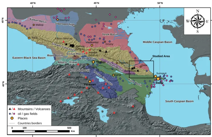
Au-Figure 1: Tectonic units and sedimentary basins of the Greater Caucasus with main mountains, volcanoes and the main gas-oil fi elds.
Figure 2: The Kasbek strato volcano with
its glaciers (Georgia, 2007).
Figure 3: Mud Volcanoes in
Qobus-tan (Azerbaijan, 2004).
Figure 4: Oil fi elds Siyazan
(Azerbai-jan 2004). Elbrus (5642 m) Ararat (5165 m) Aragats (4090m) Kasbek (5033 m) Shkhara (5201 m) Bazarduzu (4466 m) Vladikavkaz Grozny Sumqayit Baku Quba Ganja Dmanisi Tbilisi Zaqatala Yerevan Maikop Sochi Stavropol Khrami Massif Greater Caucasus Dziruli Massif Kura Basin Lesser Caucasus Stavropol high Kuban basin Adjara - Trialet Rioni Basin Alazani Basin Kartli Basin Terek Basin
South Caspian Basin Middle Caspian Basin
Eastern Black Sea Basin
45°N 40°N 50°N 45°N 40°N 500 100 0 Km Places Studied Area Mountains / Volcanoes /
oil / gas fields /
14
- Chapter 1Crossing the Central part of the EGC was the main goal for the 2009 expedition. The 2 weeks from the 9th
to the 24th of August were perturbed by bad weather.
Finally I reached to cross and to measure structural data in the valley going from Ruk Village to the sum-mit of Babadag. Thus, I completed to the north the cross-section I did in 2004 on the southern side of this summit. I was accompanied by Dr. T. Kangarli and I. Mammadov during the fi eldtrip.
1.4. G
EOMORPHOLOGICAL FEATURES OFTHE
C
AUCASUSThe main range of the Caucasus Mountains ex-tends west to east for about 1200 km from the Taman Peninsula on the northern side of the Black Sea to the Abseron Peninsula on the Caspian Sea. The Caucasus itself is divided into two mountain systems: the Great-er Caucasus and the LessGreat-er Caucasus (fi g. 1).
The Greater Caucasus itself is again divided in 2 geographical areas: the western part (Taman Peninsula – Kasbek) and the Eastern part (Kasbek – Abseron Pe-ninsula). The division is located to the north of Tbi-lisi where the mountain belt is narrower (only 60 km wide) than the Eastern and Western parts (BRAVARD
1983).
The aim of this section is to defi ne the geomorpho-logical context of the mountain belt and to use the data in the next chapters to emphasize some links with the geodynamical context. As the themes of this section are not in my fi eld of study, all the data come from literature. Whenever a paragraph is based on literature, authors are indicated at its beginning or at its end.
1.4.1. Summits and topography
The western Greater Caucasus is higher than the eastern one. It has several summits taller than 5000 m and in the eastern part no summits are higher than 4500 m. But the western northern slope goes down below 3000 m in less than 20 km and in the eastern part (Daghestan), it needs at least 40 km. In the east, summits stay at 2000 m almost until the mountain belt reaches the Terek plain (BRAVARD 1983).
The Elbrus Volcano (5642 m) is the highest summit of the Greater Caucasus, of Russia and of Europe (con-sidering that the Caucasus crest located south of the Elbrus is the boundary between Eurasian and Arabian tectonic plates). Numerous summits above 5000 m are located in the area of the Elbrus: the Greater Caucasus second highest summit is the Dykh-Tau (5205 m) and just across the border, the highest summit of Georgia
is the Shkhara Mountain (5201 m). North of Tbilisi, the Kasbek Volcano (5047 m) is also a major summit of Georgia. The Bazarduzu Mountain (4466 m) is the highest summit of Azerbaijan and is also the second most prominent1 summit (2454 m) of the Greater
Cau-casus, just after the Elbrus (4741 m). The highest sum-mit of the Lesser Caucasus and Armenia is the Aragats Volcano (4095 m). The Ararat volcano (5137 m) is the tallest peak of Turkey and is located just south of the Lesser Caucasus.
1.4.2. Climate
This section is based on the works of KOTLIAKOV &
KRENKE (1981) and KURTUBADZE (2008).
Figure 5 shows the different climatic zones of the Caucasus. The main crest of the Greater Caucasus is a boundary between temperate and subtropical zones. (KURTUBADZE 2008).
During the winter, the main crest stops the Eura-sian continental polar air or the polar front depression. In the west, the mediterranean depressions reach the western Caucasus and are absorbed by the Black Sea. The Central and Eastern Caucasus climate is mostly infl uenced by the European and Iranian depression. At 2000 m along the main crest, the average temperature
1 In topography, the prominence of a peak is the height of the
peak’s summit above the lowest contour line encircling it and no higher summit. The prominence, also known as autonomous height, relative height, shoulder drop (in North America), or prime factor (in Europe), is a concept used in the categorization of hills and mountains, also known as peaks. It is a measure of the independent stature of a summit (Wikipedia).
Table 1: Most elevated mountains of the Greater Caucasus with
their elevation and prominence rank. Elev.
Rank Prom.
rank Summit Name Elevation Prom.
1 1 1 Elbrus (RU) 5642 m 4741 m 2 6 Dykh-Tau (RU) 5205 m 2002 m 3 11 Shkhara (RU/GE) 5201 m 1365 m 4 12 Koshtan-Tau (RU) 5152 m 822 m 5 16 Pushkin (RU/GE) 5100 m 110 m 6 14 Janga (Jangi-Tau) (RU/GE) 5059 m 300 m 7 3 Kasbek (GE) 5047 m 2353 m 8 15 Katyn-Tau (RU/GE) 4979 m 240 m 9 13 Tetnuld (GE) 4974 m 672 m
10 17 Shota Rustaveli (RU/GE) 4960 m 11 4 Gora Tebulosmta
(RU/GE) 4493 m 2145 m 12 2 Bazarduzu (AZ/RU) 4466 m 2454 m
is – 8°C. Small reliefs have a relatively high infl uence on the climate. (KOTLIAKOV & KRENKE 1981).
In summer, the Caucasus stays successively at the border of the Azov anticyclone that help to melt the snow and the ice or it stays in a fi eld with a weak gra-dient that allow developing vertical convections with rain during the second part of the day. The temperature in summer decreases regularly with altitude: it passes from 20 to 25°C in the plain to 7-11°C at 2500 m. The 0°C isotherm stays at 3700 – 4000 m. The warmest month is July in the plain and August in the moun-tain. In Baku and in the Kura basin temperatures are frequently higher than 40°C. (KOTLIAKOV & KRENKE
1981).
The Central and Eastern Caucasus rainfalls reach their maxima during the summer and in the western part during the winter. In the southeast, the quantity of rain reaches 3 m/year. In the east and along the Cau-casus axis, it does not rain more than 800 mm/year. Generally the southern slopes of the Greater Caucasus receive higher amounts of precipitation than the north-ern slopes. (KOTLIAKOV & KRENKE 1981).
1.4.3. Glaciers
This section is based on the works of BEDFORD &
BERRY (1994), KOTLIAKOV & TOUCHINSKI (1974),
Kot-liakov & Krenke (1981), MILANOVSKY (2008), RASTVO -ROVA & SHCHERBAKOVA (1967), SHCHERBAKOVA (1973),
STOKES et al. (2006) and TZERETELI (1974).
The glaciers cover an area of 1400 to 1805 km2 in
the Greater Caucasus (BEDFORD & BARRY 1994).
Ko-tliakov & Krenke (1981) inventory more than 2047 glaciers. In terms of morphology, hanging glaciers and glacial cirques are located mostly in the eastern and western part of the Caucasus whereas the big-gest valley glaciers and glacial plateaus are mostly in the central part at altitudes between 4000 – 5000 m. Five glaciers have more than 40 km2: Dikhsi, Bezengi,
Tsanner, Lekhzur and Karaougoum glaciers. There are more glaciers on the northern slope than on the south-ern one, but glaciers are bigger on the southsouth-ern slope. (KOTLIAKOV & KRENKE 1981; KOTLIAKOV & TOUCHINSKI
1974; RASTVOROVA & SHCHERBAKOVA 1967; SHCHERBA -KOVA 1973; STOKES et al. 2006; TZERETELI 1974).
During the Quaternary period, glaciations reached their maximum intensity in the highest, central part of the Greater Caucasus. The mountains in the east-ern part of the Greater Caucasus are also high but the climate is dry and indications of glaciations are much more limited than in the central area. In the Lesser Caucasus and in the Armenian volcanic highlands ancient glaciations were insignifi cant and nowadays
only small glaciers exist on the Great Ararat and on the Lesser Ararat. This is mainly due to the mountain altitudes that do not exceed 3000-4000 m (with ex-ception of Mount Ararat) and to the arid local climate (MILANOVSKY 2008).
The glaciations started in the Late Pliocene in the Greater Caucasus. They can be divided in three main glacial and interglacial epochs, subdivided into phases and stages corresponding to the Early Pleistocene, the Middle Pleistocene and the Late Pleistocene-Holocene. The Quaternary glacial epoch’s names are the Eltübü, Terek and Bezengi glaciations. Although the elevations of the Greater Caucasus are higher than those of the Alps, ancient and present glaciations are more important in the Alps. A peculiarity of the Greater Caucasus area is the close interaction between glacial and volcanic process. The alternation of gla-cial epochs and phases of volcanic activity led to the formation of a relatively hard volcanic “armor” that protected moraines from total denudation (i.e. depos-its for a fourth probable Late Pliocene glaciation were preserved on the Elbrus volcanic massif). This cor-relation between glacial deposits and young volcanic rocks provides a unique opportunity to date glacial de-posits (MILANOVSKY 2008).
In the studied area, the Eastern Greater Caucasus of Azerbaijan, glaciers are not present anymore. Only fi rns can be observed on the highest summits (Sahdag, Bazarduzu and Tufandag Mountains).
1.4.4. H ydrograph y
This section is based on the works of BRAVARD
(1983), CASPERS (1957), GIRALT ET AL. (2003), HOOG -ENDOORN et al. (2005), MITCHELL & WESTAWAY (1999)
and ZENKEVICH (1957).
The main part of the hydrography of the Caucasus is linked with three hydrographic basins: the Caspian Sea, the Black Sea and the smaller Sea of Azov.
The Black Sea forms an almost isolated body of water. It is linked with the Mediterranean Sea through the Bosphorus strait, the Marmara Sea and the Darda-nelles. The Black Sea has a surface area of 413’488 km2 and its greatest length is 1149 km, the width
610 km. Its greatest depth is 2243m and the average depth 1197 m. The Black Sea has a positive water balance, which results in a net outfl ow of 300 km³ of water per year through its link with the Aegean Sea (part of the Mediterranean Sea). Mediterranean water fl ows into the Black Sea as part of a 2-way hydrologi-cal exchange. The Black Sea outfl ow is cooler and less saline, and therefore fl oats over the warm, more saline Mediterranean infl ow. The Black Sea also
re-16
- Chapter 1-26
-28
-30
1900 1920 1940 1960 1980 2000
Caspian sea level [m-gsl]
time [years] present sea level
B
-20 -24 -28 -32 -36 10 9 8 7 6 5 4 3 2 1 0 time [103 years BP]Caspian sea level [m-gsl]
Mangyshlak regression Derbent regression ? ? ? present sea level ?
A
Figure 5: Climate zones of the Caucasus area (KURTUBADZE 2008).
Figure 6: (A) Estimated Holocene sea-level fl uctuation of the Caspian Sea (RYCHAGOV 1993a; RYCHAGOV 1993b; RYCHAGOV 1997) and
ceives river water from fl uvial systems to the north of the Sea (Dnieper and Danube), from the Rioni River coming from the Caucasus and from the Sea of Azov. The Black Sea is the world’s largest meromictic basin where the deep waters do not mix with the upper lay-ers of water that receive oxygen from the atmosphere. As a result, over 90% of the deeper Black Sea volume is anoxic water (CASPERS 1957).
The Sea of Azov is a shallow basin connected with the Black Sea by the Strait of Kerch. Its hydrography is controlled by the infl owing waters of the Don and the Kuban rivers. The Sea of Azov occupies a total area of 37’600 km2. The greatest depth of the sea is
13.2 m, the average depth 7.2 m. The annual infl ow of fresh water comes at 50.5 % from the Don River, 19.5% from the Kuban River and the rest from sur-face rainfall and groundwater. The average salinity is 1.12%. (CASPERS 1957).
The Caspian Sea is the largest inland water body on the planet with its 1200 km long and 200 to 550 km wide. It is a closed reservoir of saline water (salin-ity of 1.2 to 1.25%). It is made up of three sub-basins (north, central and south) with an average water depth of 210 m, a maximum depth of 1024 m, an estimated surface area of about 374’000 km2. About two-thirds
of the water volume belongs to the southern part. The main water outputs of the Caspian Sea are related to evaporation (380 km3 per year). The water inputs to
the Caspian Sea are represented by river infl ows (80% of the total water input), by precipitation (between 11 and 18%) and by groundwater (between 2 and 9%). The main river infl ow is given by the Volga River (82%), the Ural River (3%). The other major contribu-tor are the western rivers (Kuma, Terek, Sulak, Samur and Kura rivers) which collectively make up 11.5% of the total input, the Iranian rivers to the south that provide 3.5% of the total input and fi nally the Emba River in west Kazakhstan. The terraces along the coast show the variation of the sea level. The present-day water level of the Caspian Sea is situated at -27.5 m.a.s.l (fi g. 6B). The lowest documented sea level is estimated at 50 m below global sea level at the end of the Pleistocene or early Holocene (Mangyshlak re-gression) (fi g. 6A). The Derbent regression, around 1500 BP, reached a minimum of at least -32 m (fi g. 6A). The Caspian Sea reaches its greater extend dur-ing the Late Akchagyl transgression 1.2 Myr ago and several other transgressions occur during the Abseron and Baku stages. During the peak of the most recent Khvalyn transgression at ~15-12 kyr, the Caspian sea reached 47 m above mean sea level (75 m above its present level) allowing it to overfl ow into the Black Sea via the Manych palaeo-strait. (GIRALT et al. 2003;
HOOGENDOORN et al. 2005; MITCHELL & WESTAWAY
1999; ZENKEVICH 1957).
The Northern slope of the Greater Caucasus is divided by two main river systems: the Kuban River systemfl owing into the Azov Sea and the Terek River fl owing in the Caspian Sea. The Kuban River fl ows 870 km from its spring near the Elbrus to the Sea of Azov. The Terek River starts fl owing in the southwest of Mount Kasbek and reaches the Caspian Sea after 623 km. In the east several smaller systems drain the Caucasus: Sulak, Samur, Qusarcay, Qudiyalcay, Qa-racay, Valvalacay rivers. The Kuban, Terek and Sulak rivers have their upper part perpendicular to the main axis of the Greater Caucasus and they become parallel only when they reach the steppes. The Samur River system has the particularity to fl ow almost parallel to the main axis since its upper part (BRAVARD 1983).
The southern slope of the Greater Caucasus and the Northern slope of the Lesser Caucasus are drained by the Kura River system that fl ows into the Caspian Sea and the Rioni River system that fl ows into the Black Sea. The Kura River is the largest watercourse in the southern Caucasus; its total length is 1515 km. It origi-nates in the springs located 2720 m above sea level on the northeast slopes of Kizil-Giadik (Turkey). It then fl ows through the territory of Georgia and the lower reaches of the river are in Azerbaijan where it fl ows through the Kura Basin into the Caspian Sea. In the Kura Basin the Kura River merges with it major tribu-tary, the Arak River. The Arak River drains the Eastern Lesser Caucasus (HOOGENDOORN et al. 2005).
1.4.5. Hominid records of Dmanisi (Georgia)
and Caucasus
This section is based on the works of de LUMLEY &
LORDKIPANIDZE (2006) and LJUBIN & BOSINSKI (1995).
Excavations carried out since 1991 at the open-air site of Dmanisi, Georgia, have yielded four craniums, three mandibles, about 15 postcranial remains and a dozen isolated teeth. These remains correspond to at least four individuals, two adults and two adolescents. They were excavated from a precise stratigraphic, palaeontological and archaeological context above a basalt fl ow dated by K/Ar between 1.8 and 1.9 ± 0.01 Myr in a volcanic ash layer dated by 40Ar/39Ar to 1.80 ± 0.05 Myr. The interest of these discover-ies is fourfold: (1) the dates obtained by diverse ra-diochronometric methods and by palaeomagnetism demonstrate, for the fi rst time, that Man was present at the gates of Europe, in Transcaucasia at a much ear-lier period than that established by the classical sce-nario; (2) faunal and pollens analyses have revealed that the environment was close to a savannah type, but much richer in water resources than the African en-vironment. It was a temperate climate, with a mosaic of different landscapes due to the geomorphological
18
- Chapter 1diversity of the region, made up of valleys, lakes and the nearby mountains of the Greater and Lesser Cau-casus; (3) the settlement of this human group could have been a direct consequence of a more humid en-vironment, which followed a generalised aridifi cation of the east of Georgia at the end of the Pliocene and which attracted fauna from both the east of the Eura-sian continent and the north of the African continent; (4) the morphofunctional aspects of these humans are close to those of Homo habilis and to those of the most archaic Homo erectus, which were the only species known in Africa up until now. Ascribed to a new spe-cies, Homo georgicus, small in size measuring 1.5 m with a cranial capacity of 600 to 700 cm3 (half of
mod-ern man’s capacity), they represent the ancestors of a long European or Eurasian lineage. Two new concepts can be retained: (1) the exodus from Africa took place earlier than previously thought, dating back to at least 1.8 Myr ago. It was carried out by Homo georgicus, a group close to Homo habilis; (2) it is no longer valid to base explanations of Man’s migratory capacity in terms of cranial development. Homo georgicus, with a small brain volume, already had the faculty to adapt to a more favourable environment for his survival (DE
LUMLEY & LORDKIPANIDZE 2006).
Following the Dmanisi records, there is no clear evidence of hominid in this region until the Middle Pleistocene, a fact that may indicate an absence of rel-evant deposits, lack of fi eldwork, or genuine absence. In the Middle Pleistocene, several caves were formed that were subsequently used for denning by cave bear and occasionally by hominids. Examples are Azyk in Azerbaijan, the caves of Kudaro I, II, and Tcona in Georgia and Treugol’naya in southern Russia. All ex-cept Treugol’naya have Acheulean assemblages con-taining some hand axes and few cleavers. Layer 7 at Treugol’naya has been dated by TL to 583 +- 25 kyr; the basal assemblage from Azyk may be slightly older, and the other caves rather young (LJUBIN & BOSINSKI
1995).
1.5. G
EOLOGY OF THEG
REATERC
AUCASUSAND ITS SURROUNDING AREAS
The Greater Caucasus belt forms a morphological barrier along the southern margin of the Scythian Plat-form, running from the northern margin of the Eastern Black Sea Basin to the South Caspian Basin. It devel-oped during several phases of deformation in Mesozo-ic-Cenozoic times (BRUNET et al. 2009a; BRUNET et al.
2003; ERSHOV et al. 2003; ERSHOV et al. 2005; JACKSON
et al. 2002; KAZMIN & TIKHONOVA 2006; KHAIN 1975;
KHAIN 1997; KOPP & SHCHERBA 1985; SAINTOT et al.
2006a). It is located within the active convergence
zone between the Arabian and Eurasian plates. Based on the study of McClusky et al. (2000) and Vincent et al. (2007), the partitioning of Arabian – Eurasian plate convergence is divided between right-lateral strike-slip faulting on NW-SE striking faults in eastern Turkey and thrusting along the Caucasus thrust front. Total shortening across the Lesser and Greater Cauca-sus is 10 ± 2 mm/yr, with almost 60% of this shorten-ing occurrshorten-ing across the Greater Caucasus (MCCLUSKY
et al. 2000).
Several Foreland basins and tectonic units are located around the Greater Caucasus orogen (fi gs. 1 and 8). In the north, the western Indol – Kuban fore-deep and the eastern Terek-Caspian forefore-deep are fore-deep molasse basins. These foredeeps are fi lled with thick Oligocene to Quaternary molasse, the depth of the Pre-Mesozoic basement reaching 10 to 12 km. They are separated by the Stavropol High where the base-ment lies at the highest level (up to 1-2 km below the surface). In the southeast, the deep Kura intermon-tane trough separates the Greater Caucasus from the Lesser Caucasus. It is fi lled by Oligocene-Quaternary molasse reaching a thickness of 8 to 10 km and the Pre-Alpine basement has subsided in places to 10 to 12 km. Finally in the southwest, the basement plunges deep under the molasse fi lling of the Rioni intermon-tane deep. The western Rioni and the eastern Kura molasse basins are bound southward by the Lesser Caucasus Mountains, eastward by the Caspian Sea and westward by the Black Sea (ADAMIA et al. 2010;
BRUNET et al. 2003; KHAIN 1975). The geodynamics of
all the area is infl uenced by super deep sedimentary basins: the Black Sea basins and the South Caspian Basin. Based on geophysical data, an oceanic crust with a depth reaching 25 km forms the basement of the South Caspian (GREEN et al. 2009). It is a remnant of
the eastern part of the Mesozoic Great Caucasus Basin corresponding to a back-arc basin with a rifting phase starting at the Lower-Middle Jurassic (BRUNET et al.
2009a; BRUNET et al. 2003). In the west, the Black sea
is divided into a western oceanic part and an eastern part that is fl oored by highly thinned continental to oceanic crust. The Andrusov-Archangelsky ridge (or mid-Black Sea ridge) divides them. Black Sea basins are interpreted as a Late Cretaceous to Eocene back-arc extensional features (NIKISHIN et al. 2001).
Structurally the Greater Caucasus is the deformed southern margin of the Late Paleozoic Scythian Plat-form (ERSHOV et al. 2003). The present structure of the
Greater Caucasus exposes its Paleozoic basement in dominantly southward-directed thrust slices only west of longitude 44°E (fi g. 7). The Jurassic and Cretaceous series are present in tight or isoclinal folds associated with thrusts across the range around the exposed Pale-ozoic core. The vergence of folds is predominantly
towards the south. Plio-Quaternary strata are folded into elongated, linear south vergent anticlines on the southern side of the range (between the Kura and Rio-ni basins). However there are north directed structures on the northern margin, especially in the northeast (Dagestan). The Moho under the range is at a depth of up to 60 km (ALLEN et al. 2003; ERSHOV et al. 1999;
ERSHOV et al. 2003; ERSHOV et al. 2005). The Caucasus
orogeny itself started in late Eocene times (BARRIER et
al. 2008a; BARRIER et al. 2008b). The Pontides - Black
Sea – Caucasus – South Caspian area was affected by increasingly intense compressional tectonics.
The investigated area covers the eastern part of the Greater Caucasus: the Eastern Greater Caucasus (EGC). It corresponds to the Azerbaijan part of the mountain belt. It is mostly composed of Mesozoic and Cenozoic sediments. It contains remnants of a sedimentary basin, the Greater Caucasus Trough, and, on its slopes, the erosional products of the tertiary orogeny. From a structural point of view, this area is marked by an important uplift of the central part creat-ing remarkable thrusts to the north and to the south. It is also affected by NNE-SSW right-lateral strike-slip fault and a NNE-SSW sinistral strike-slip fault. They are highlighted by the drainage pattern of major rivers but also by mountain crests direction.
1.5.1. Earthquakes
The Greater and Lesser Caucasus are seismically active zones linked to the rapid and non-uniform plate convergence between Arabia and Eurasia (ALLEN et
al. 2004; ALLEN et al. 2006; JACKSON 1992; JACKSON
et al. 2002; PHILIP et al. 1989; PRIESTLEY et al. 1994;
Figure 7: Simplifi ed cross section of the eastern part of the Caucasus.
N S
Kura Basin Terek Basin
?
Tertiary sediments
Mesozoic sediments Mesozoic & Tertiary intrusions
Accreted Island arc crust Intruded Continental
crust (”Europe”)
Continental crust (”Europe”)
Lesser Caucasus Greater Caucasus
0 km 50 km 100 km 0 km 50 km 100 km 0 km 50 km 100 km Root Zone
Tethys Ocean subduction ?
TRIEP et al. 1995). The Lesser Caucasus and the
ad-joining Anatolian Plateau show a predominance of strike-slip focal mechanisms associated with a sys-tem of vertical faults. In the Greater Caucasus, on the contrary, convergence is accommodated predom-inantly by reverse focal mechanisms associated to thrusting with a general N-S to NE-SW compression (BARAZANGI et al. 2006; COPLEY & JACKSON 2006;
KOÇYIGIT et al. 2001; TAN & TAYMAZ 2006), see also
discussion in ALLEN et al. (2004) and JACKSON (1992).
Slip vectors based on earthquake focal mechanisms show a general top to the south thrusting. Strike-slip mechanisms exist but are rare. Present seismicity is unevenly distributed across the GC (fi g. 8). A zone with a higher seismic activity is observed on the south slope of the Greater Caucasus west of Tbilisi (Georgia) in the Racha area (TRIEP et al. 1995).
Stud-ies of focal mechanisms and focal depths show that this seismicity is linked to several active fault strings in the subsurface of the Gagra-Dzhava zone (GAM -KRELIDZE & KULOSHVILI 1998; TRIEP et al. 1995). They
show south directed slip vectors.
Seismicity is extending into the Middle and South Caspian Sea (KOVACHEV et al. 2006). In the Abseron
zone focal mechanisms show NNE-SSW oriented thrusting (JACKSON et al. 2002) and seismic activity
may be linked with an extension/termination of the Greater Caucasus towards the east and/or with young north-directed subduction of the South Caspian Ba-sin to the north under the Abseron (ALLEN et al. 2002;
KNAPP et al. 2004). The seismicity further south as
well as in the Qobustan desert area shows a westward component of motion relative to Eurasia, suggesting underthrusting towards the west (JACKSON et al. 2002).
20
- Chapter 1Black Sea
Caspian Sea
Adjara-T rialet FTB Adjara-T rialet FTB Kuban Basin. Kuban Basin. Lesser Caucasus Lesser CaucasusKartli - Kura Basin
Kartli - Kura Basin
Rioni B. Rioni B. T erek Basin T erek Basin Alazani B. Alazani B. Kura Basin Kura Basin Stavropol High Stavropol High Qobustan Qobustan Paleozoic Jurassic Cretaceous Adjara-T rialet Lesser Caucasus T ertiary Basins
Active frontal zone Foothills and FTB Zone of fastest uplift
Earthquakes Cr oss sec tion 40°E 50°E 48°E 46°E 44°E 42°E 40°N 42°N 44°N Kilometres 0 125 250 500 Figur e 8: Simpli
fi ed geological and structural map of the Greater Caucasus with the major earthquakes. Cross-section corresponds to
1.5.3. Volcanoes and magmatism
The Neogene-Quaternary volcanism is limited to three areas area in the Greater Caucasus: the Kasbek area (fi g. 2), the Central Georgia area and the Elbrus area (LEBEDEV et al. 2006). This neo-volcanism is
rep-resented by major stratovolcanoes like the Elbrus Mt. (5642 m) or the Kasbek Mt. (5047 m).
The young magmatism has involved the formation of basalt fl ows, stratovolcanoes and hypabyssal intru-sions which have become unroofed by rapid erosion. The stratovolcanoes form a northward prolongation of a chain of similar edifi ces in eastern Turkey. Ara-gats Mt. has erupted mainly basalts, basaltic andesites and dacites, whereas Elbrus has produced mainly dac-ites and rhyoldac-ites. Some studies have suggested that the volcanism has been caused by subduction of an ocean basin which formerly linked the Black and Cas-pian Seas, by the delamination of the lower part of the thickened mantle lithosphere or by the heating of the Lower continental crust or mantle lithosphere which accompanies crustal thickening (MITCHELL & WESTA -WAY 1999).
The magmatism of the Greater Caucasus that created the present volcanoes was concentrated around 2.8 Myr. Young volcanism persists for ~250 km along the western Greater Caucasus from Elbrus to Kasbek. Kasbek is considered no longer active but some erup-tions of Elbrus post-date the last glaciation and fuma-roles near its summit emit a vapour plume (MITCHELL
& WESTAWAY 1999).
In the Lesser Caucasus, the Aragats and Ararat volcanoes are considered inactive and both are cov-ered by an icecap. East and north of Aragats Mt., other volcanoes form the Gegham plateau and the Javakhet plateau (MITCHELL & WESTAWAY 1999).
More details about the magmatism history are in Lebedev (2006).
1.5.4. Mud Volcanoes
Azerbaijan and the South Caspian Sea are known for their hydrocarbon fi elds, and represent the region with the highest abundance of continental and offshore mud volcanoes (YAKUBOV et al. 1971). More than 400 active
mud volcanoes are present in this region, both onshore and offshore (ALIYEV et al. 2002; ALIYEV et al. 2009;
YAKUBOV et al. 1971). Their size is variable (heights up
to 600 m and surfaces up to 10 km2) (fi g. 3).
Their presence in the South Caspian region is mainly due to three factors: (1) rapid quaternary infill of one of the world deepest sedimentary ba-Some seismic activity is also seen in the central
part of the Eastern Greater Caucasus, as well as in the Kura basin. On the northern slopes, the Dagestan FTB and the recent faults in the Terek Basin show a higher concentration of earthquakes pointing to active thrust tectonics in this area.
Studies on palaeoseismology remain rare but con-fi rm the existence of inherited faults and the possi-ble 2000 years recurrence of high magnitude events (ROGOZIN & OVSYUCHENKO 2005; ROGOZIN et al. 2002).
1.5.2. Uplift and shortening
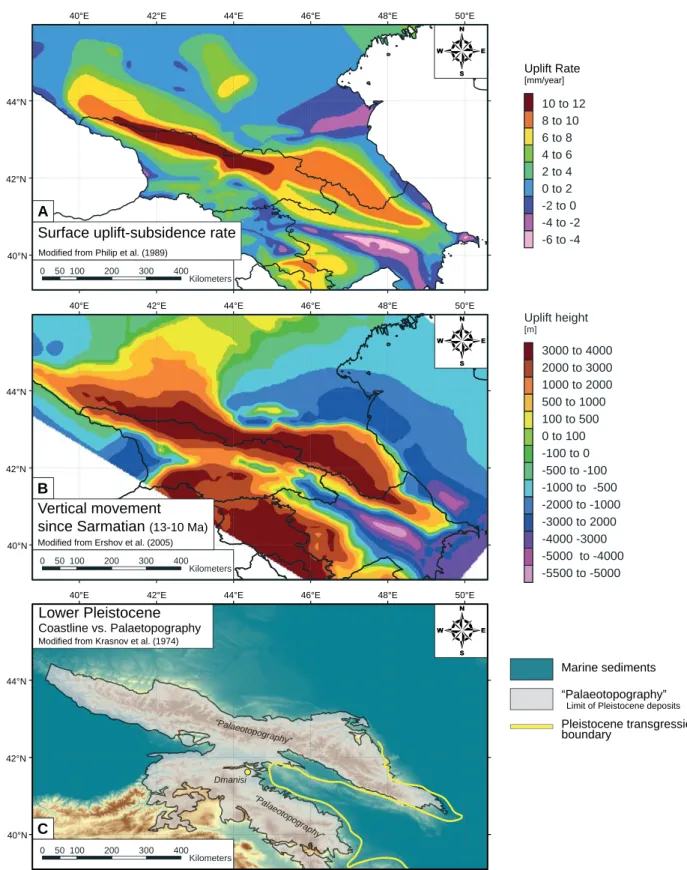
ERSHOV (2005) and PHILIP et al. (1989) locate
the main surface uplift in the central part of the mountain range and they date it of Middle Neogene age (fi g 9A and 9B). Marine sediments (BUDAGOV
1963), old marine terraces (KRASNOV 1974; MITCH -ELL & WESTAWAY 1999; POPOV et al. 2004) (fi g. 9C),
geomorphological (RASTVOROVA & SHCHERBAKOVA
1967), and thermochronological studies (KRAL &
GURBANOV 1996) suggest an average surface uplift
rate of minimum 0.33 mm/yr to 1 mm/yr for the last 10 Myr, but Rastvorova (1967) suggested that it reaches 10 mm/yr since the last glaciations. This last assumption is mainly based on river incision and the relationship between incision and surface uplift could not be considered simple and a detailed analysis of the topography has to be done (MITCHELL
& WESTAWAY 1999).
Total shortening across the Greater Caucasus is uncertain, with estimates reported in the range 5-60 km (DOTDUYEV 1986; GAMKRELIDZE & GAMKRELIDZE
1977). Triep et al. (1995) point out that a minimum of 33 km of shortening is needed to account for present-day relief assuming Airy isostasy. The onset of con-vergence in the Greater Caucasus is estimated at 2.5 Myr by BURTMAN (1989), although shortening may
have begun as early as 5 Myr (TRIEP et al. 1995).
Us-ing this range of parameters (33-60 km shortenUs-ing in 2.5 to 5 Myr) gives an average shortening rate in the range 7-24 mm/yr. In contrast, WESTAWAY (1990)
re-examined neotectonic information and concluded that overall shortening rates across the Greater Caucasus are likely no greater than ~5 mm/yr and that most of the convergence between Arabia and Eurasia is taken up to the south in eastern Turkey and northwestern Iran. Assuming uniform deformation rates, the GPS estimate of present-day shortening made by MC
-CLUSKY (2000) across the Greater Caucasus (5-6 +/- 2
mm/yr) supports WESTAWAY (1990) analysis.
Accord-ing to KADIROV et al. (2008), the Eastern Greater
Cau-casus undergoes, in the east, a convergence rate of 10 +/- 1 mm (48° E longitude) and in the west 4 +/- 1 mm (46°E longitude).
22
- Chapter 1C
40°E 42°E 44°E 46°E 48°E 50°E
40°N 42°N 44°N
0 50100 200 300 400
Kilometers
Modified from Krasnov et al. (1974)
Lower Pleistocene
Coastline vs. Palaetopography
4
Marine sediments “Palaeotopography”
Limit of Pleistocene deposits
Pleistocene transgression boundary Dmanisi “Palaeotopography” Uplift height [m] -5500 to -5000 -5000 to -4000 -4000 -3000 -3000 to 2000 -2000 to -1000 -1000 to -500 -500 to -100 -100 to 0 0 to 100 100 to 500 500 to 1000 1000 to 2000 2000 to 3000 3000 to 4000 B
40°E 42°E 44°E 46°E 48°E 50°E
40°N 42°N 44°N
0 50100 200 300 400
Kilometers
Modified from Ershov et al. (2005)
Vertical movement since Sarmatian (13-10 Ma)
4
“Palaeotopography” Uplift Rate [mm/year] 10 to 12 8 to 10 6 to 8 4 to 6 2 to 4 0 to 2 -2 to 0 -4 to -2 -6 to -440°E 42°E 44°E 46°E 48°E 50°E
40°N 42°N 44°N
0 50100 200 300 400
Kilometers
Modified from Philip et al. (1989)
Surface uplift-subsidence rate
4
AFigure 9: Maps of surface uplift rates, vertical movement, and Lower Pleistocene coastlines. (A) Uplift-subsidence rates: highest rates
of 10-12 mm/year are found in the central part of the western Greater Caucasus (PHILIP et al. 1989). High subsidence is occurring in the Kura Basin; (B) Total vertical movement since Sarmatian (10-13 Myr). Strong subsidence is seen north and south of the eastern termination of the Greater Caucasus in Azerbaijan (ERSHOV et al. 2005); (C) Lower Pleistocene coastline – map of coastline (KRAS-NOV et al. 1974) which separates the area of the former marine domain and zone above sea-level with Pleistocene deposits, and area with unknown amount of palaeotopography. Notice the position of Dmanisi (Georgia) where hominid remnants dated back to 1.8 Myr