TOURISM OPPORTUNITY ANALYSIS:
DINOSAUR TRACKS
IN THE GRANDE CACHE AREA
Presented to
Alberta Economic Development
By
Strategy Plus
9608 – 100 Street Edmonton, Alberta T5K 0T6In Association with:
IRIS Environmental Systems
Banff and CalgaryInsight Research Solutions Inc. Edmonton
Richard T. McCrea Edmonton
EXECUTIVE SUMMARY
Several sites of dinosaur footprints and trackways have been exposed on provincial Crown lands near the Town of Grande Cache in northwest Alberta, in an area that was formerly part of a coal mine operated by Smoky River Coal Ltd. (SRCL). While no dispositions or mining leases currently exist on the track sites, coal mining applications will be considered in the area over the next few years.
The purpose of this study, commissioned by Alberta Economic Development, is twofold:
1. To determine the capacity of the dinosaur tracks and related palaeontological resources within the Grande Cache region to be developed as marketable tourism products, and 2. If capacity exists to develop the resource as a marketable tourist attraction, to develop an
implementation plan for use by interested parties in Grande Cache to pursue development of tourism products and programs related to the dinosaur footprints and trackways.
The study involved several components, including: an assessment of the scientific significance of the track sites; a survey of other sites to determine their best practices; a review and assessment of resource protection, management and access considerations; an inventory and assessment of existing tourism in the area; and an assessment of the tourism potential of the track sites based in part on the experiences of other sites. Several possible tourism scenarios are presented, along with a detailed implementation strategy.
Eighteen track sites have been identified to date, half of which have some tourism potential. More footprints and trackways may potentially be unearthed if surface mining resumes. Footprints from known track sites are estimated to number in the tens of thousands. In addition to the dinosaur track sites, numerous specimens of plant fossils are exposed in the area.
These footprints and trackways are exposed on steep rock walls, many of which are over 60 or 70 meters high. The tracks are quite spectacular under proper light conditions. Many can be viewed from the haul road, with some right beside the road and others from 75 to 150 meters away. A majority of track sites in the world show only partial trackways or are located on flat surfaces, making viewing difficult for the public. Having several thousand footprints visible on the footwalls is a condition rarely seen on this scale. Over time, natural forces will destroy the tracks, although some may survive for several generations if human disturbance is prevented. As tracks slough off slopes or become less distinct, other tracks may emerge from beneath the successive layers of sandstones and mudstones of the Gates Formation in which they are found.
Key findings and recommendations of the study include:
The dinosaur footprints and trackways are scientifically significant in a North American and international context. Of the eighteen sites identified to date, nine are located close to existing coal haul roads and of high enough quality to be included as part of a guided tour. •
• The track sites, together with other resources in the Grande Cache area, satisfy several criteria required for determining tourism significance, including uniqueness, opportunities for interpretive programming, availability of other tourism attractions and services, local interest, success of similar attractions elsewhere, and potential linkages with other related attractions.
• Guided tours provided by a local Grande Cache group as a controlled access tourism product, with limited development at the track sites, is recommended. The experience would include a three to four hour guided bus tour to the track sites using a twenty-passenger vehicle appropriately equipped with heavy duty suspension and multi-wheel drive.
• The Grande Cache Visitor Centre would provide an offsite interpretive experience and a staging point for tours. New and upgraded displays, as well as interpretive programming, are recommended. Onsite development (on a phased basis), may include fencing, viewpoints, walkways, turn around areas, wind shelters, portable toilets, and lighting for improved daytime viewing and special evening programs.
• Guided bus tours would operate primarily in the summer season (June 15 to September 15). Led by trained and certified guides delivering a professionally developed interpretive program, bus tours would cost a minimum of $25 to $30 per person. Based on operating at an estimated 40% capacity with one tour per day for the first year or two, attendance would be in the range of 750 to 1000 visitors/year. Visitation could vary, depending on such factors as number of tours per day and per season, as well as marketing and promotional initiatives.
• Other similar attractions note that guided tours to a remote location to see dinosaur track sites will be of interest to a wide range of visitors. In the longer term, it should be possible to attract larger numbers of visitors, as is demonstrated by visitation in 2000 at such other sites as: Yoho Burgess Shale in British Columbia (1,275), Copper Ridge Dinosaur Tracks in Utah (6,044), T-Rex Discovery Centre in Saskatchewan (7,000), Dinosaur Depot Museum in Colorado (15,608), Red Gulch Dinosaur Tracks in Wyoming (18,000), and Dinosaur Ridge in Colorado (40,000).
• A non-profit society, such as the “Friends of the Dinosaur Tracks Society”, should be formed locally to take the lead role in developing and managing the tourism product and programming. While services may be provided through contracted operators, a non-profit society will ensure that the dinosaur tracks tours remain a local undertaking and benefit the community. It will also provide an entity for fund raising and volunteer participation. Development of a tourism product such as this will require the long term commitment of a number of individuals who are prepared to provide time and energy over several years to help to make this a sustainable, thriving business.
• A pilot tour program, including contracted use of a bus or van and a professionally developed interpretive program, should be initiated in the summer of 2001. This pilot program should be designed to test the market and operational factors, and provide a basis on which to develop detailed business, operational, facility development, and marketing plans for the tour product.
• The track sites are located on Provincial Crown land zoned as “multiple use” within a former coal mine area. While the area of the track sites is currently being reclaimed, applications are being developed relative to resource extractive activity in the surrounding area. Tourism operations will need to be able to co-exist with other resource uses in the longer term.
• A protective notation placed on the track sites in the short term by Alberta Community Development, followed by designation as a Provincial Historic Resource (PHR), is critical in terms of effectively protecting the track sites for future visitor use and enjoyment.
• Safe, reliable and affordable access to the resource is a critical prerequisite for any onsite tourism product. Vehicular access to the area is possible along roads that were developed as coal haul roads and that are currently the responsibility of the Alberta government. It would be cost prohibitive for a tourism operator to assume responsibility for maintenance and reclamation of these roads independently. It is recommended that short term letters of authority be arranged with Alberta Sustainable Resource Development until other resource uses and responsibility for road maintenance are resolved over the next year or two. When that occurs, it should be possible to negotiate a “consent’ agreement with the resource company/companies to use the road on a controlled basis for bus tours to the track sites.
• Once coal mining operations resume in the area, loaded mining trucks will use the same roads as tour vehicles, creating dust, noise, and potential safety and liability concerns. In order for both mining and tourism operations to safely co-exist, it will be essential to negotiate agreements in terms of required insurance and indemnity, as well as how tour vehicles will safely operate within the active mining area (e.g., schedules, radio control, pull off areas). In addition, protective clothing (e.g., boots, coveralls, goggles, and hard hats) may be required.
• When access is resolved, it will be possible to apply to the Alberta government for a disposition on the track sites that will allow for the limited development noted above. This application would address such components as access, liability and indemnity concerns, an operations plan, and a proposed development plan on a phased basis.
A detailed implementation strategy is provided in the report that outlines the key actions, timelines, responsibilities and order of magnitude costs for developing guided bus tours to the track sites on a controlled access basis, with limited development of facilities onsite and enhancement of the Visitor Centre.
TABLE OF CONTENTS
PAGE
EXECUTIVE SUMMARY... i
1. BACKGROUND AND STUDY PURPOSE ... 1
1.1. STUDY PURPOSE ... 1
1.2. STUDY COMPONENTS... 2
2. DESCRIPTION OF STUDY AREA AND RESOURCES ... 3
2.1. REGIONAL SETTING ... 3
2.2. LOCATION AND GENERAL DESCRIPTION OF DINOSAUR TRACK SITES ... 3
2.3. INVENTORY OF TOURISM AND RECREATION FACILITIES AND SERVICES 6 2.3.1. Tourism and Recreation Attractions and Facilities... 6
2.3.2. Tour Operators ... 6
2.3.3. Tourism Accommodation – Fixed Roof (Hotels/Motels/Bed and Breakfast)... 7
2.3.4. Tourism Accommodation – Campgrounds... 8
2.3.5. Transportation Services... 8
2.3.6. Other Services ... 8
2.3.7. Selected Special Events... 9
2.4. TOURISM VISITATION IN THE GRANDE CACHE AREA... 10
2.4.1. Visitor Statistics ... 10
2.4.2. Reason for Visit to Grande Cache... 11
2.4.3. Survey of Visitors to Grande Cache ... 12
2.4.3.1. Visitors from the United States... 12
2.4.3.2. Visitors from Canada... 13
3. RESOURCE PROTECTION AND TOURISM ACTIVITY MANAGEMENT... 14
3.1 OVERVIEW OF NATURAL RESOURCES AND PROTECTION ISSUES ... 14
3.1.1. Location and Climate... 14
3.1.2. Landscape Elements... 14
3.1.3. Biophysical Resources ... 17
3.1.4. Wildlife Resources... 17
3.2. RESOURCE MANAGEMENT AND PROTECTION ISSUES ... 19
3.2.1. Protection of Palaeontological Resources... 19
3.2.2. Protection of Biophysical and Wildlife Resources ... 22
3.3. LAND TENURE, LAND USE, ACCESS, PUBLIC SAFETY AND SECURITY ... 23
3.3.1. Competing Land Use ... 23
3.3.2. Land Tenure for Tourism Activities... 25
3.3.3. Historical Resources Designation ... 27
3.3.4. Access to Dinosaur Track sites ... 29
3.3.5. Liability and Public Safety Issues ... 34
3.3.6. Mine Site Security... 35
3.4. INTERPRETATION AND EDUCATION... 36
4. TOURISM OVERVIEW ... 37
4.1. HIGHLIGHTS OF VISITOR INFORMATION FROM OTHER RELATED SITES... 37
4.1.1. Alberta Provincial Historic Sites and Cultural Attractions... 37
4.1.2. Information from Other Sites or Facilities ... 38
4.1.3. Visitor Information Centres... 40
4.1.4. Alaska Visitor Information... 42
4.2. LEARNING VACATIONS ... 43
PAGE
5. BEST PRACTICES OVERVIEW ... 49
5.1. INTRODUCTION ... 49
5.2. PROTECTION OF, AND ACCESS TO, PALAEONTOLOGICAL RESOURCES .... 49
5.2.1. Applicability to Grande Cache ... 50
5.3. INTERPRETATION AND EDUCATION FACILITIES ... 51
5.3.1. Development Felt to be Appropriate for Grande Cache... 51
5.4. VISITOR SAFETY... 52
5.5. FINAL THOUGHTS BY RESPONDENTS ... 52
6. ASSESSMENT OF DINOSAUR FOOTPRINTS AND TRACKWAYS ... 53
6.1. CRITERIA FOR SCIENTIFIC ASSESSMENT OF TRACK SITES... 53
6.2. ASSESSMENT OF THE IMPORTANCE OF GRANDE CACHE TRACK SITES .... 53
6.3. RANKING IN COMPARISON WITH OTHER TRACK SITES... 55
6.3.1. Other North American Track Sites ... 55
6.3.2. Other Top Ten Sites in the World... 57
6.4. CRITERIA FOR ASSESSMENT OF TOURISM MARKETABILITY... 59
6.5. TOURISM POTENTIAL OF GRANDE CACHE TRACK SITES ... 59
7. SCENARIOS REGARDING TOURISM PRODUCTS/PROGRAMMING... 66
7.1. Scenario 1: STATUS QUO, ACCESS ON-SITE BY SPECIAL ARRANGEMENT ONLY ... 66
7.1.1. Type of Development/Programming... 66
7.1.2. Implications for Tourism in Grande Cache... 67
7.2. SCENARIO 2: NO DEVELOPMENT ONSITE, CONTROLLED ACCESS ONLY TOURS PROVIDED BY LOCAL GRANDE CACHE GROUP ... 68
7.2.1. Type of Development/Programming... 68
7.2.2. Implications for Tourism in Grande Cache... 69
7.3. SCENARIO 3: LIMITED DEVELOPMENT ONSITE, CONTROLLED ACCESS ONLY TOURS PROVIDED BY LOCAL GRANDE CACHE GROUP ... 71
7.3.1. Type of Development ... 71
7.3.2. Implications for Tourism in Grande Cache... 73
7.4. SCENARIO 4: POSSIBLE PUBLIC ACCESS (20 – 40 YEARS IN THE FUTURE) 74 7.4.1. Type of Development ... 74
7.4.2. Implications for Tourism in Grande Cache... 74
7.5. SCENARIO 5: VISITOR INFORMATION CENTRE ENHANCEMENT ... 75
7.5.1. Type of Development ... 75
7.5.2. Implications for Tourism in Grande Cache... 76
8. CONCLUSIONS AND RECOMMENDATIONS ... 77
8.1. CONCLUSIONS... 77
8.2. RECOMMENDATIONS... 82
9. IMPLEMENTATION STRATEGY ... 85
PAGE APPENDICES
APPENDIX A: INVENTORY OF GRANDE CACHE DINOSAUR TRACKS... 99
APPENDIX B: BEST PRACTICES MATRIX ... 103
APPENDIX C: TOURISM TABLES ... 121
LIST OF TABLES IN REPORT TABLE 1: TOURISM AND RECREATION FACILITIES AND SERVICES ... 6
TABLE 2: TOUR OPERATORS ... 7
TABLE 3: FIXED ROOF ACCOMMODATION FACILITIES IN GRANDE CACHE ... 7
TABLE 4: CAMPGROUNDS IN THE VICINITY OF GRANDE CACHE ... 8
TABLE 5: SOURCE OF ROOM DEMAND (1999) ... 11
TABLE 6: REASON FOR VISIT ... 11
TABLE 7: HOW AMERICAN VISITORS FOUND OUT ABOUT GRANDE CACHE ... 12
TABLE 8: OVERNIGHT LOCATION BEFORE AND AFTER GRANDE CACHE ... 13
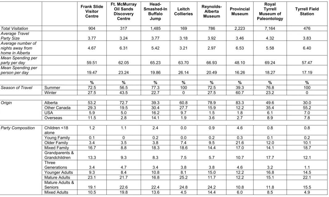
TABLE 9: ATTENDANCE FIGURES AT PALAEONTOLOGICAL SITES... 39
TABLE 10: VISITOR INFORMATION STATISTICS 1998 – 2000 ... 41
TABLE 11: IMPLEMENTATION STRATEGY... 85
LIST OF MAPS IN REPORT MAP 1: GRANDE CACHE AREA REGION... 5
1. BACKGROUND AND STUDY PURPOSE
Several sites of dinosaur footprints and trackways have been exposed on provincial Crown lands near the Town of Grande Cache in northwest Alberta. This area of Crown land was formerly leased by Smoky River Coal Ltd. (SRCL), but reverted to the Crown after the company went through receivership in 2000. Grande Cache Coal Company Inc. (GCC) is currently developing a proposal to re-establish a coal mine in part of the former SRCL mine site. Other resource uses are also being considered in the area.
Other plant fossil resources have also been documented within the region, many in the same areas as the dinosaur footprints and trackways (Wan, 1996). When there was active coal mining in the area, limited access for guided tours to view the mine and the dinosaur tracks was provided by SRCL. Since the closure of the mine, access is only available by special arrangement through Alberta Sustainable Resource Development.
Interest has been expressed locally about the potential for developing these resources as a tourism attraction. A small display area, including a cast specimen of some footprints as well as other fossils, is located at the Grande Cache Visitor Information Centre. This has led to increased awareness of, and interest in visiting, the track sites; however, viewing of the actual resource onsite is presently not available.
1.1. STUDY PURPOSE
The purpose of this study, commissioned by Alberta Economic Development, is twofold: 1. To determine the capacity of the dinosaur tracks and related palaeontological
resources within the Grande Cache region to be developed as marketable tourism products, and
2. If it is determined that capacity exists to develop the resource as a marketable tourist attraction, to develop an implementation plan for use by interested parties in the community of Grande Cache to pursue development of tourism products and programs related to the dinosaur footprints and trackways.
1.2. STUDY COMPONENTS
This tourism opportunity analysis involved the following components:
1. Review and assessment of resource protection and management requirements and implications in relation to tourism opportunities and activities involving the dinosaur track sites. This included clarifying the government administrative context, as well as contacting resource companies to determine the requirements for dinosaur track site tours to safely co-exist with future coal mining and other resource extractive activities in the area. Four principal needs were assessed:
• Effective and sustained protection for the dinosaur footprints and trackways, • Safe, reliable and affordable access,
• Short and long-term land tenure/disposition, and • Assured public safety and associated liability risks.
2. Survey of other dinosaur and palaeontological sites in Western North America, including documenting best practices related to such things as resource management and protection, funding, marketing, and merchandizing.
3. Review and assessment of the scientific significance of the Grande Cache dinosaur footprints and trackways in a North America and global context.
4. Inventory and review of existing tourism products and activity in the Grande Cache area, and assessment of the tourism marketability of the dinosaur track sites, based on local information as well as the experience of other related sites.
5. Identification of optional scenarios for Grande Cache, as well as conclusions and recommendations regarding possible tourism products involving the dinosaur trackways.
6. Preparation of a detailed implementation strategy relative to actions, timelines, responsibilities and order of magnitude costs required to implement the preferred scenario.
2. DESCRIPTION OF STUDY AREA AND RESOURCES 2.1. REGIONAL SETTING
The Town of Grande Cache is located in northwest Alberta, north of Jasper National Park and at the north end of Willmore Wilderness Park, within the Municipal District of Greenview No. 16. It is situated on Highway 40, the Big Horn Highway, about midway between the Yellowhead Highway to the south and Highway 43 to the north. The Town of Hinton lies 143 km to the south, and the City of Grande Prairie is 182 km to the north. Highway 40 provides part of the paved connection between the Yellowhead Highway and Mile Zero of the Alaska Highway at Dawson Creek, B.C.
Since completion of the paving of Highway 40 in 1996, there has been an increase in traffic along the highway, including travelers passing through the area on their way to or from Alaska. Highway 40 forms part of the shortest route to and from Alaska for travelers using the scenic Icefields Parkway through Banff and Jasper National Parks.
The economy of Grande Cache is based on forest products, oil, natural gas, coal, correctional services, electrical production, and tourism and recreation.
The area is richly endowed with scenic resources and extensive recreation and tourism opportunities. Grande Cache is the major service centre in the area, providing a range of services. It is located adjacent to Willmore Wilderness Park, acting as the northern gateway for access to the park. It is also surrounded by Crown land, providing such opportunities as wildlife viewing, hiking, horseback riding, white water rafting and kayaking, all-terrain vehicle use, hunting, and fishing.
2.2. LOCATION AND GENERAL DESCRIPTION OF DINOSAUR TRACK SITES
Track sites with footprints of dinosaurs and other terrestrial vertebrates are found north of the Town of Grande Cache in what formerly was the SRCL mine site. Footprints and trackways were exposed on surface footwalls upon the removal of coal from the Number Four coal seam in the Grande Cache Member of the Gates Formation (Lower Cretaceous, Lower Albian). Many of the track sites are situated on nearly vertical slopes over 60 or 70 meters high, and are quite spectacular under proper light conditions.
Map 1 identifies the location of Grande Cache in a regional context, as well as highlights the former SRCL mine site in which the dinosaur track sites are located.
After being notified of the existence of the dinosaur footprints and trackways in 1989, research expeditions were sent by the Royal Tyrrell Museum of Palaeontology to collect footprint specimens and data. SRCL cooperated in these studies by granting access to the track sites, most of which are located near active haul roads within the mine area.
During the course of this research, eighteen track sites were discovered and there was potential for more to be unearthed as a result of continued surface mining of coal in the area. Footprints from all of these track sites are estimated to number in the tens of thousands, with one track site alone (W3 Main) having approximately 10,000 footprints. The diversity of footprint types is relatively high, with four ichnogenera (trace fossil genera) of theropod footprints (Irenesauripus mclearni, Columbosauripus ungulatus, Gypsichnites pascensis and Irenichnites gracilis), one ichnogenus of ankylosaur footprints (Tetrapodosaurus borealis), and at least three ichnogenera of avian footprints (Aquatilavipes ichnospecies).
In addition to the dinosaur track sites, numerous specimens of plant fossils were documented in the adjacent areas (Wan, 1996). Attempts were made during the course of this Tourism Opportunity Analysis to identify any other published evidence of palaeontological resources in the area. No significant resources in the immediate area were identified; however, it is possible that additional resources may be identified in future that would add to the tourism potential of the area.
The primary researcher for much of the work undertaken relative to the dinosaur footprints and trackways in the area has been Richard T. McCrea, a graduate student in palaeontology in the Department of Earth and Atmospheric Sciences at the University of Alberta who is currently completing a PhD on the subject. McCrea has participated on the consulting team for this report, and his findings are incorporated.
While SRCL is no longer active in the area, access to the dinosaur track sites is still restricted, and the entire site is under control of the Provincial Crown. A portion of the main haul road will be required by the Grande Cache Coal Company Inc. (GCC) for access to Numbers 7 and 8 mine areas. This company is currently undertaking an Environmental Impact Assessment relative to further mining activity in the area. Other companies are also actively considering access to the area for other resource uses. The dinosaur track sites are located on Provincial Crown land outside of this lease area in an area that is undergoing reclamation. Access to the track sites is via a former mine road with a locked gate, currently controlled by Alberta Sustainable Resource Development. Special arrangements must be made with the local land manager in order to have access to the area.
2.3. INVENTORY OF TOURISM AND RECREATION FACILITIES AND SERVICES 2.3.1. Tourism and Recreation Attractions and Facilities
Table 1 identifies tourism and recreation facilities in or near the Town of Grande Cache
TABLE 1: TOURISM AND RECREATION FACILITIES AND SERVICES
Recreation Facility/Service Activity Location
Grande Cache Tourism and Interpretive Centre
Visitor Information. Cultural and natural history displays, exhibits by local artists, gift shop. Opened 1996.
On Hwy 40 at south entrance to Town. Open year round.
Grande Cache Golf & Country
Club 9 hole golf course and full facilities Just north of town, off Hwy 40 Akasaka Recreation Centre Swimming pool, arena, curling rink,
fitness centre, tennis courts, ball diamonds, soccer fields
In town. Hide-A-Way Camp Main lodge and 6 cabins, sleeping up
to 6 adults and 2 children each Pierre Grey’s Lake, 32 km south on Hwy 40 Willmore Wilderness Park Extensive backcountry, trail riding Adjacent to town.
Mason Creek Day Use Area Picnic area East on Highway 40 Grande Cache Lake Day Use
Area
Picnic area, swimming beach, fishing, water skiing
East on Highway 40 Fireman’s Park Picnic Area Picnic area In town.
Victor Lake fishing and canoeing East of town.
Griffith Trail 10 km trail for hiking, biking Trail circles town.
Sulphur Rim Trail 7 km walking path Along Sulphur Rim Canyon Twin Falls Trail 1 km walking trail To Hells Creek & Twin Falls
Source: Grande Cache Website; brochures; and Town of Grande Cache: Tourism Development and Retiree Attraction Strategy; Ference Weicker & Company; September 2000
2.3.2. Tour Operators
In 2000, 11 tour operators provided services in the Grande Cache area (see Table 2). Most of these were adventure and activity oriented, with only a couple providing interpretive programming as part of the experience. Two of the tour operators were from outside the immediate area, with one of these offering an opportunity to visit the track sites as part of the tour.
TABLE 2: TOUR OPERATORS
Operator Service Provided
Taste of Wilderness Tours Guided hiking/backpacking trips, emphasize local history & culture, nature interpretation and appreciation, environmental awareness Wild Blue Yonder River outfitter, rafting & canoeing on Smoky and Sulphur Rivers & local
lakes, trail riding and hiking in Willmore Wilderness Park. Dan’s Rafting Tours Rafting trips on Smoky and Kakwa, raft rentals, fishing, hunting Avalanche Adventures & Tours Jet boat tours, hunting & fishing trips, equipment rental Sheep Creek Backcountry
Experience Ltd Backcountry cabins, horseback riding, fishing, hunting, hiking and snowmobiling High Country Vacations Class “A” guide and outfitter, pack trips, “healing journeys” Sulphur Gates Outfitting Class “A” guide and outfitter in the Wilmore Wilderness Park U Bar Enterprises Trail riding, combination riding and rafting excursions
Wild Hay Adventure Tours Trail rides, pack trips, photography trips, native & western culture trips Alta-Can Tours Inc Coach tours, specializing in Japanese market for fall Aurora Borealis;
Edmonton based
Timberwolf Tours Ltd Adventure Tours, including hiking, animal/bird watching; Sherwood Park based
Source: Grande Cache website, personal communicationand Town of Grande Cache: Tourism Development and Retiree Attraction Strategy; Ference Weicker & Company; September 2000, Pg 88/89.
2.3.3. Tourism Accommodation - Fixed Roof (Hotels/Motels/Bed and Breakfast)
As of September 2000, there were six fixed roof hotel/motel accommodation establishments and two bed and breakfast operations in the town, providing a total of 228 rooms (see Table 3). These properties provide mid-range accommodation, largely used by work crews from resource industries. There are no luxury properties in Grande Cache.
•
• Ference Weicker & Company reported in 2000 that the hotel and motels have been in operation for an average of 19 years, employing 88 people, many on a part-time and/or seasonal basis. Occupancy rates vary on a seasonal basis and between properties, although an estimated 50% occupancy level represents over 40,000 room rentals per year and over $2 million in room rental revenues for the community.
TABLE 3: FIXED ROOF ACCOMMODATION FACILITIES IN GRANDE CACHE
Name Type Units Restaurant
Acorn Motel Motel 52 No
Alpine Lodge Motel Motel 36 Yes
Big Horn Motor Inn Motel 37 Yes
Grande Cache Hotel Hotel 48 Yes
Inn on the Valley Motel 48 No
Misty Mountain Apartments Apartment 5 No
Mountain Quest Bed & Breakfast Private Home 1 No Mount Hamell Bed & Breakfast Private Home 1 No
Total Fixed Roof Units Available 228
Source: Town of Grande Cache: Tourism Development and Retiree Attraction Strategy; Ference Weicker & Company; September 2000, Pg 87 and Grande Cache website
2.3.4. Tourism Accommodation – Campgrounds
• The Marv Moore Municipal Campground is the only serviced campground in the area, while several other campgrounds provide basic services (See Table 4).
• In the summer of 1999, there were 3,800 visitors to the Marv Moore Municipal Campground, originating from: Alberta (69.8%), British Columbia (14.2%), United States (9.5%), Other Canada (3.7%), and International (2.8%).
TABLE 4: CAMPGROUNDS IN THE VICINITY OF GRANDE CACHE
Name Sites Distance from Town
Marv Moore Municipal Campground (serviced) 77 In town Smoky River South Forestry Provincial Recreation Area 22 3 km N on Hwy 40 Sulphur Gates Forestry Provincial Recreation Area,
Staging Area and Campground 12 5.5 km N on Hwy 40/7.5 km SW Sheep Creek Forestry Provincial Recreation Area 9 20 km N on Hwy 40 Pierre Grey’s Lake Provincial Recreation Area 101 32 km E on Hwy 40 Big Berland Forestry Provincial Recreation Area 20 60 km SE on Hwy 40 Kakwa River Forestry Provincial Recreation Area 14 80 km NE on Hwy 40
Source: Town of Grande Cache: Tourism Development and Retiree Attraction Strategy; Ference Weicker & Company; September 2000, Pg 88
2.3.5. Transportation Services
The Bighorn Highway 40 is the main route connecting Grande Cache with Hinton and the Yellowhead Highway 16 in the south and with Grande Prairie in the north
•
• •
•
The Grande Cache Municipal Airport, 19 km east of town, has a 5000 meter runway and operates on a 24 hour basis. There is currently no scheduled service. The airport handles charter and emergency services.
A rail line situated near Grande Cache provides transport for coal and commodities. Greyhound bus service 6 days/week to Hinton and 5 days/week to Grande Prairie, along with charter bus service, is provided by a local company (Trax)
There is local taxi service provided by Grande Cache Taxi.
2.3.6. Other Services
• Grande Cache General Hospital offers 24 hour emergency care
• 14 restaurants and take out food services, three of which are located in a hotel or motel. • 5 grocery/convenience stores, 2 liquor stores and 11 souvenir and craft stores
• Range of automotive service facilities
2.3.7. Selected Special Annual Events
• Rocky Mountain Children’s Festival, 1st week in May • Music Festival, 2nd week in May
• Wild River Rendezvous, 2nd weekend in June • Aboriginal Cultural Days
• Canadian Death Run, extreme foot race, August long weekend
• Canadian Death Race, extreme mountain bike race, September long weekend • Mud Bog Challenge, August
• Canadian Death Snowshoe Race, beginning in 2002
• Passport to the Peaks, encouraging participants in the program to climb the 21 peaks around the Town of Grande Cache, ongoing
2.4. TOURISM VISITATION IN THE GRANDE CACHE AREA 2.4.1. Visitor Statistics
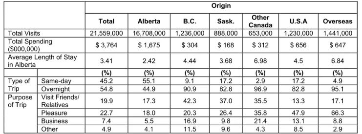
Grande Cache is located within the Canadian Rockies Tourism Destination Region (TDR), cooperating with Hinton, Canmore, and Banff and Jasper National Parks in marketing initiatives. However, when considering current visitor use patterns and statistics (e.g., users of the hotel rooms in Grande Cache are primarily industrial crews and business travelers rather than tourists or tour groups), Grande Cache is perhaps more appropriately considered in the context of visitation to the Alberta North Tourism Destination Region, the boundary of which is just to the north of the Town. Some statistics regarding visitor use in the surrounding Alberta North Tourism Destination Region are presented below, and other tables are included in Appendix C.
• In 1999, 1.5 million people included Alberta North in their travels. This represents approximately 7% of the total 21.5 million visits made in and to Alberta.
• Visitors who included Alberta North as part of their trip spent $242 million on their entire trip. They had a slightly higher tendency to overnight on their trip than did visitors to other regions of the province (52.3% vs 47.7%). Their purpose of trip tended to be to visit friends/relatives (18.9%), compared to pleasure (16.0%).
• In 1999, approximately 10% of Alberta’s 661 fixed-roof accommodation properties and 9% of the rooms were located in Alberta North. The average establishment had 69.4 rooms, an average occupancy rate of 64.8%, with an average room rate of $41.40.
• The source of room demand for Alberta North is significantly different from the provincial average in that industrial crews and business travelers account for most room nights. Industrial crews accounted for 36.7% in 1997, growing to 40.8% in 1999. Business travelers declined slightly from 40.5% in 1997 to 37.6% in 1999.
• The source of room demand also differs in the Canadian Rockies, where tourists (39.8%) and tour groups (38.1%) account for most of the demand (See Table 5).
TABLE 5: SOURCE OF ROOM DEMAND 1999
Region Industrial Crews (%) Business Travelers (%) Tourists (%) Tour Groups (%) Convention Groups (%) Other (%) Alberta North 40.8 37.6 9.3 1.8 3.3 7.1 Alberta Central 42.6 24.9 14.4 1.6 4.2 2.3
Edmonton & Area 8.7 43.1 22.1 3.7 12.2 0.1
Canadian Rockies 0.8 1.9 39.8 38.1 17.7 1.6
Calgary and Area 7.3 42.6 28.6 7.1 9.9 4.5
Alberta South 41.5 22.6 24.7 2.6 2.5 6.8
Total Alberta 18.0 29.0 24.9 11.1 10.0 7.0
Source: Alberta Economic Development
2.4.2. Reason for Visit to Grande Cache
In the “Town of Grande Cache: Tourism Development and Retiree Attraction Strategy” study, businesses were asked what visitors indicated was their reason for visiting Grande Cache (See Table 6). People traveling on business are the primary users of accommodation (76%), followed by people traveling through on the highway (16%). The majority of people participating in adventure activities identify Grande Cache as their primary destination (68%), while 19% were traveling through the area and 10% were visiting friends and relatives.
TABLE 6: REASON FOR VISIT
Reason for Visit Accommodation (%)
Adventure (%)
Traveling through by automobile 16 19
Visiting friends and relatives 5 10
Traveling to the Grande Cache area on business 76 3 Visiting Grande Cache as their primary destination 3 68
Total 100 100
Source: Town of Grande Cache: Tourism Development and Retiree Attraction Strategy; Ference Weicker & Company; September 2000. Pg 92
The survey also asked businesses to identify the percentage of their revenue in terms of visitor origin. Accommodation operators felt that the majority (62%) of their visitor revenues came from the rest of Alberta, 23% from the local area, and 11% from Other Canada, with 2% each from the United States and other countries. Outdoor adventure operators felt that the majority of their revenues came from visitors from the rest of Alberta (43%), followed by the rest of Canada (27%), the United States (16%), other countries (8%) and the local area (6%). All other businesses surveyed felt their revenues came from users living within the Grande Cache area (62%), from the rest of Alberta (24%), the rest of Canada (10%), other countries (3%), and the United States (1%).
2.4.3. Survey of Visitors to Grande Cache
In 2000, Ference Weicker & Company, conducted 111 telephone surveys with visitors to Grande Cache. Of the respondents, 50 were visitors from the United States and 61 were Canadians (39 from Alberta and 22 from B.C.). Highlights of the survey are outlined in the following sections.
2.4.3.1. Visitors from the United States
90% of American visitors were traveling to Alaska • • • • • • •
The average length of trip was 48 days, with an average of 2.3 people per party For 86% of respondents, it was their first visit to Grande Cache
Only 20% had planned to stay in Grande Cache before leaving home Only 10% participated in outdoor activities during their stay
96% would recommend the town as a place to visit.
Most visitors found out about Grande Cache on their way to the destination (32%), from the Milepost (26%), or by word of mouth (16%)
TABLE 7: HOW AMERICAN VISITORS FOUND OUT ABOUT GRANDE CACHE Respondents (#) Percent (%) Publications
Milepost 13 26
AAA 3 6
Good Sam Club 1 2
Brochure 1 2 Other On way to destination 16 32 Word of mouth 8 16 Been before 4 8 Map 2 4 Friends/relatives 2 4 Sign 1 2 Information Centre 1 2 Total 50 100
Source: Town of Grande Cache: Tourism Development and Retiree Attraction Strategy; Ference Weicker & Company; September 2000, Pg 96
Americans were also asked how satisfied they were with their experience in Grande Cache on a scale of 1 to 5, where 5 is very satisfied and 1 is not at all satisfied. The majority (64%) rated their experience as very satisfied.
•
• The majority of Alaska bound American travelers (58%) had come through the Banff/Jasper corridor. Another 12% had traveled on the British Columbia/Cassiar route, and 3% had traveled along the Edmonton/Grande Prairie route.
On the return trip from Alaska, 53% traveled through Grande Cache on Highway 40, 7% took the Grande Prairie/Edmonton route, and 13% traveled through B.C.
•
•
•
The majority of the travelers (56%) chose to go through Grande Cache on the way north to Alaska, while (42%) went through the area on their way back. Only 2 travelers used this route both ways.
On their way to Alaska, visitors from the United States averaged about 4 hours a day on the road. Table 8 shows where travelers spent the night before and the night after Grande Cache.
TABLE 8: OVERNIGHT LOCATION BEFORE AND AFTER GRANDE CACHE
Centre Stayed on way
to Grande Cache Stayed the night after Grande Cache Grande Cache (km) Distance from
Banff/Lake Louise 10 10 443 Jasper 10 7 214 Dawson Creek 9 15 322 Fort St. John 10 4 401 Calgary 1 2 626 Ft. Nelson 0 1 789
Source: Town of Grande Cache: Tourism Development and Retiree Attraction Strategy; Ference Weicker & Company; September 2000, Pg 117
• When asked what would make US visitors to Grande Cache stay longer, they noted the following activities: scenery/sightseeing/hiking (15 respondents), visiting historical parks and monuments (8 respondents), fishing (8 respondents), being more aware of what was available (5 respondents), and wildlife viewing (5 respondents).
2.4.3.2. Visitors from Canada
50% had been in Grande Cache before • • • • • • • • •
61% had planned to stay in Grande Cache before leaving home 79% only stayed one night
46% participated in outdoor activities while in town, including hiking (11 respondents or 18%), golf (10 respondents or 16%), whitewater rafting (2 respondents or 3%), and fishing, wildlife viewing, and biking (1 respondent or 1.6% each)
The average trip length was 11 days
98% would recommend the town as a place to visit 79% plan to return to Grande Cache
The majority (49.2%) of Canadians were traveling to or from other regions
When asked how satisfied they were with their experience in Grande Cache, the majority (57.4%) indicated very satisfied.
3. RESOURCE PROTECTION AND TOURISM ACTIVITY MANAGEMENT
Opportunities for tourism activities at dinosaur tracks exposed at the former SRCL (Smoky River Coal Limited) coal mine site are dependent on four principal needs:
1. Effective and sustained protection for the dinosaur tracks and trackways; 2. Safe, reliable and affordable access;
3. Short and long-term land tenure (disposition); and 4. Assured public safety and associated liability protection.
This section provides an overview of regional and site resources, and assesses many key issues that will influence decisions about potential tourism activity at the dinosaur track sites.
3.1. OVERVIEW OF NATURAL RESOURCES AND PROTECTION ISSUES 3.1.1. Location and Climate:
The dinosaur tracks at the former SRCL mine site (12-Mine and 9-Mine) are found on recently exposed slabs of steeply inclined sedimentary sandstone at elevations between 1,400 and 1,500 meters above sea level (asl). The area lies within the Rocky Mountain Foothills ecoregion approximately 15 km northwest of Grande Cache and 7 km west of Highway 40, Alberta’s “Bighorn” Highway. All tracks were exposed during surface mining operations, which removed a thick, overlying coal seam. Coal mining in this area has ceased and all permits, licenses, approvals, authorities and dispositions previously held by SRCL have been disclaimed back to the Provincial Crown. Future resource exploration and extraction activities are anticipated.
The regional climate is typical of high elevation areas within the Upper (northern) Subregion of Alberta’s Foothills Natural Region. Cool winters and moderate summers ensure that Grande Cache enjoys no predictably recurring frost-free period. This area has the highest summer precipitation in Alberta, averaging 340-mm., and mean annual precipitation of 540-mm. Winters are long and often cold. Occasional Chinook winds provide periods of relief from invasions of cold arctic air.
3.1.2. Landscape Elements
In the Grande Cache area, the Alberta Foothills are extensively underlain by sedimentary deposits of clastic (silts, sandstones and conglomerates) or organic (coal) origin. These materials were deposited along the western perimeter and shores of a large inland sea that existed during the Mesozoic Era, specifically during the Jurassic and Cretaceous periods.
Reaching its peak extent nearly 100 million years ago, this inland sea (the Kiowa / Skull Creek Sea) was created at a time when high sea levels allowed the western oceans to flood B.C.’s Rocky Mountain trough and the interior plains. The inland sea stretched from the Arctic Ocean to the Gulf of Mexico, including central and eastern Alberta.
Much of this sedimentary material was deposited prior to and during the first period of Rocky Mountain building, the “Columbian” orogeny (period of uplifting). The Columbian orogeny extended throughout the period from 175 to 100 million years before present, coinciding with the Middle Jurassic and Early Cretaceous periods. During this time, the climate varied considerably, including periods now associated with more tropical climates. Throughout this period of deposition, dinosaurs roamed the margins of the Mesozoic sea, moving up and down its western perimeter. Dinosaur skeletal remains (bones) found in Alberta, Montana and Wyoming are the remains of animals that became trapped and buried by silts and sands washed into the sea by rivers swollen in flood. Dinosaur skeletal remains in Alberta are found in much younger sediments (sediments deposited at least 30 million years more recently) than those in which the Grande Cache dinosaur tracks are found.
Between 85 and 45 million years before present, a second period of active mountain building affected this region. The “Laramide” orogeny, caused by northeasterly pressure resulting from a collision of two geological ‘plates’ (the North American and Pacific plates), led to the development of the Front Ranges of the Rocky Mountains and the Alberta Foothills. This upward movement of sedimentary and other materials drained the inland sea, and brought an end to depositional processes in what is now the Grande Cache region.
McCrea (2001) reports that the dinosaur tracks found near Grande Cache were made approximately 100 million years ago by animals occupying estuarine, shoreline and swampy habitats on the western perimeter of the inland sea. At that time, these same silty and sandy deposits (Grande Cache Member, Gates Formation) were generally level, but would be squeezed and up thrust by tectonic forces of the Laramide orogeny to create the alternating synclines and anticlines that shape the foothills in this region. A syncline is a down fold in stratified rocks from whose central axis the beds rise upward and outward in opposite directions. Synclines alternate with anticlines, which have sharply arched folds from whose central axis sedimentary strata slope downward in opposite directions.
Prior to uplifting, new layers of inter-bedded silt and sand, deposited by Cretaceous rivers, subsequently covered many of these areas. Still later, dense tropical forests covered this region for an extended period. The accumulated debris from decaying organic matter was compressed by overburden and by the forces of tectonism to form coal seams. One such seam, No. 4 seam, has been mined in the Smoky River area using surface and underground mining methods.
This coal seam is of metallurgical grade coal averaging 6-m in thickness in the former SRCL mine site. Slag and tailings of this high-grade metallurgical coal have been used to supply power at the nearby ATCO power plant. The removal of overburden and coal by surface mining over the past two decades exposed the dinosaur tracks, making them potentially available for scientific research and tourism activities.
It has been less than 11,000 years since the glaciers retreated from the larger valleys that drain eastward from the Rocky Mountains. Glaciation was the principal landscape shaper of the last 1.5 million years during the Pleistocene Period. During this period, four principal glacial “advances” have been recorded in North America, each of different extent and duration.
Many earth scientists and archaeologists believe that the Foothills Region near Grande Cache may have been ice-free during the most-recent (Wisconsin) advance, potentially providing a corridor that could be used by plants, animals and humans to survive and travel. An ice-free corridor may have provided the only inland route by which native people occupied the interior plains as the great continental glaciers receded to the northeast. Such a corridor may have extended to a land bridge connecting North America to Asia by the Bering Sea. At that time, sea levels were lower than at present due in part to water stored in glaciers. Archaeological remains excavated west of Grande Prairie (Saskatoon Mountain) and near Banff indicate that native people occupied the Foothills Region and major Rocky Mountain valleys at least 10,500 years ago. These findings are amongst the oldest archaeological finds in western North America, and may reveal much about the possible existence of an ice-free corridor along the front ranges of the Rocky Mountains during a period of intensive glaciation.
Several interesting geological features are located close to Grande Cache. The most popular is the Sulphur Gates, located at the confluence of the Sulphur and Smoky Rivers. At this location, the rivers have carved an impressive canyon through less resistant layers of vertically bedded conglomerates of the Gates Formation.
3.1.3. Biophysical Resources:
Information about the biophysical resources of the region is summarized in several provincial publications and in Jasper author, Ben Gadd’s Handbook of the Canadian Rockies. Provincial publications consulted include Ecoregions of Alberta by Strong and Leggat; Natural Regions and Subregions of Alberta A Revised Classification for Protected Areas by Achuff; and Natural Regions, A Framework for Alberta’s Special Places. Complete references are cited at the end of this report.
The Grande Cache region lies within Alberta’s Upper Foothills Subregion. The region is diverse in landscapes and appearance as it is transitional between the Boreal Forest, Rocky Mountain, and Foothills Natural Regions (ecoregions), but is below treeline and elevations associated with Rocky Mountains Alpine Subregion. This region is sharply differentiated from more southerly regions of the Foothills Natural region by a cooler climate and wetter summers. West of the Smoky River, the broad valleys of the foothills (characterized by grassy meadows, aspen stands, and lodgepole pine) slowly yield to higher subalpine valleys where lodgepole pine forests yield to white spruce and eventually to subalpine fir. Biodiversity is lower here than in the Lower Foothills Subregion because of climatically induced lower diversity in plant communities.
To the east, characteristics of the Wetland Mixedwood Subregion of the Boreal Forest Natural Region appear. Here, glacial lake sediments intermix with glacial tills and organic soils. Poorly drained areas have a cooler temperature regime. Forests are comprised of interspersed stands of aspen, balsam poplar, white spruce and birch. Poorly drained areas may be covered with a carpet of peat land, willow-sedges and black spruce. Pine and mixed conifer forests prefer better-drained upland regions, but at this latitude are cool enough to support a rich flora of arboreal and ground lichens – preferred habitat for woodland caribou.
3.1.4. Wildlife Resources
Sitting immediately north and east of Wilmore Wilderness Park (4,464 sq. km.) and at a distance of 403 km by road from Edmonton, the nearest major population centre, wildlife resources in this region are diverse and abundant. The Smoky River Coal Mine site is situated immediately adjacent to extensive areas zoned by Alberta for Prime Protection or as Critical Wildlife Habitat for bighorn sheep and woodland caribou. The region is home to 20% of Alberta’s population of bighorn sheep, to mountain goat, and to the West Central Alberta woodland caribou herd with an estimated population of approximately 5,000 animals.
Bighorn sheep and backfill area, Photo courtesy of Jan Bloomfield
Woodland caribou are classified as an endangered species pursuant to the Alberta Wildlife Act. Caribou herds have declined dramatically in the last three decades, giving rise to special efforts to protect this species and its critical habitats. Threats to caribou populations include: industrial activity on critical habitat; uncontrolled access; loss of habitat to human activity; and disturbance of traditional travel routes. Caw Ridge, situated north of the 12-Mine site, has been rated as critical summer and winter caribou range. In winter, caribou occupy lichen-rich forests, including a broad zone crossing a 40 km stretch of Highway 40 south of Grande Cache. Although opportunities exist for enhancing interpretation programs and facilities in the region, tourism practices that would allow potential increased disturbance of wildlife should not be promoted.
Diverse landscapes and vegetation associations support rich biodiversity. Near Grande Cache, mountains, foothills, boreal forest and broad valleys converge to provide a setting for diverse habitats. Other large mammals that share habitat in this area include black and grizzly bears, mountain goat, elk, deer, moose and cougar. The area also features diverse small mammal and bird populations. The area’s rivers support a variety of native fish species including bull trout, Arctic grayling, rainbow and brook trout.
Backcountry travel on foot and horseback, as well as hunting and fishing, are important to residents and visitors alike. These traditional activities provide economic gain for several outfitting and guiding businesses in the Grande Cache area.
3.2. RESOURCE MANAGEMENT AND PROTECTION ISSUES:
All dinosaur tracks considered in this study are located within the former SRCL mine site. Map 2 illustrates the boundaries of the former coal mining properties and the general location of the dinosaur track sites. The track sites with potential for tourism activity are all located north of Sheep Creek. The bridge crossing Sheep Creek is about 7.5 km from the intersection of the Smoky River haul road and Highway 40.
Subsequent to SRCL going into receivership, coal mining has ceased and all leases have been disclaimed back to the provincial Crown. The area will be subject to additional applications for dispositions and some former mining areas and roads will be reclaimed by Alberta Sustainable Resource Development. The applicable land use zoning is “Multiple Use”. The northern edge of the site is identified as winter habitat for bighorn sheep and woodland caribou. Weyerhaeuser Canada Ltd. has a Forest Management Agreement Area adjacent to, and within the northeastern margins of, the former mine site.
With the exception of the dinosaur track sites, no other special resource features have been identified within the perimeter of the former coal mine site (north and south of Sheep Creek), and no protected designation status has been assigned to resources in this area.
3.2.1 Protection of Palaeontological Resources
Palaeontological resources include dinosaur tracks as well as extensive plant fossils that are scattered throughout the mine area, and are common near dinosaur track sites. Tyrrell Museum officials responsible for resource protection echo the recommendations of museum and palaeontology experts from other sites that the dinosaur tracks, and the geological matrix within which they are found, be left undisturbed, and subject to natural forces of weather and erosion.
This course of action is unanimously preferred over interventionist practices such as further rock bolting, or chemical treatments to prevent water penetration. Such interventionist practices are seen as having greater potential to damage palaeontological resources than simple protection from human disturbance. Tyrrell Museum officials have recommended placing additional backfill at the base of some of the steeper slopes containing track sites as a less intrusive stabilization measure. These additional fills might also be used for the construction of viewing facilities for visitors.
Over time, natural forces will destroy existing tracks. Tyrrell Museum staff note that some slopes may fail in a five to ten year time period while others may extend for several human generations provided human contact is restricted. As tracks slough off slopes or become less distinct, other tracks will emerge from beneath the successive layers of sandstones and mudstones that comprise the Gates Formation. The advice of a structural engineer may be warranted to determine the stability of slopes proposed for public access.
The Tyrrell Museum also supports recommendations to create latex casts of the more significant dinosaur tracks at the Smoky River sites. Such casts can be used to create replicas for scientific study and record, and for off-site exhibits and program props. Few large track replicas exist at present in museums and tourism displays in the region.
Alberta Community Development (Tyrrell Museum) is responsible for the protection and custody of all palaeontological resources in the province, including the dinosaur tracks sites near Grande Cache. Measures for site development for tourism and resource protection should be determined by, or in consultation with, Tyrrell Museum staff who have expressed their support for community initiatives to increase awareness of, and provide access to, these track sites.
Tyrrell Museum officials have confirmed Richard McCrea’s assessment of the scientific importance of the Smoky River dinosaur track sites. While Museum officials support this tourism initiative, at the present time they do not have the necessary funds to extend protection measures, nor to undertake additional research. Such funding should be secured from other sources if tourism development of the track sites proceeds.
Although the wholesale destruction of palaeontological resources by human activity is a definite risk, natural processes will result in constant alteration of resources as they are sloughed off as a result of slope failures and frost-thaw cycles. The key to minimizing human disturbance to dinosaur tracks is to install fences that are gated and locked. Tourism activities may be useful to scientists by providing a form of site monitoring and documentation. Involving visitors in a comprehensive program to photograph and map all track sites may provide an interesting “field” experience managed by a sustained volunteer group. Such a program would benefit resource protection and potentially provide a vehicle for accessing funding resources for installing protective facilities, conducting research, and developing interpretive media and visitor facilities.
Restricting access (direct contact) to all significant track sites is required for both resource protection and public safety. Direct access may be possible to the W1 track site where a slab of “coaly” rock features so many ankylosaur footprints intermingling on the site that Richard McCrea has described this intermingling of tracks as forming a “dinoturbated” landscape.
3.2.2 Protection of Biophysical and Wildlife Resources
In addition to palaeontological resources, tourism activities should include plans to minimize potential impacts to wildlife, wildlife habitat and reclaimed areas. Restricted access to active mining areas has provided a measure of protection for biophysical resources and wildlife; however, public use is permitted and will likely increase when mining ends.
The track sites of principal tourism potential are on the southern edge of an area designated as winter habitat for bighorn sheep, mountain goats and woodland caribou. Active mine reclamation may create additional attractive winter habitat for sheep. Despite their inquisitive behaviour and ready habituation to human activity, winter remains a critical period for all ungulates, requiring that special measures be put in place to minimize disturbance. Winter visitor use is expected to be quite limited, reducing the potential for significant impacts. Bighorn sheep in this area have become habituated to human activity. During the course of active mining and reclamation, ‘no-shooting’ provisions protect mine workers and sheep.
Reclamation provides attractive forage and escape habitat; however, in the event that the roads in the former coal mine site became open to public access, these sheep would be easy prey to hunters and poachers. The regulatory provisions of Alberta hunting laws apply on all public lands and active resource development sites.
During certain periods of the year, woodland caribou cross Highway 40, moving through traditional winter habitat areas. Travelers to Grande Cache from both the south and the north need to be made aware of the potential for encountering caribou on or near the roadway, and of the response required to protect these animals whose status is rated as threatened by the Committee on the Status of Endangered Wildlife in Canada (COSEWIC).
Weyerhaeuser Canada operates a timber-harvesting program adjacent to the former mine site, north of Sheep Creek. Visitors should be cautioned of the need to protect forest resources from the effects of fire. Risk of grass fire is increased in sites that have been reclaimed. To mitigate this risk, smoking should be banned or permitted only in controlled areas that are equipped with facilities for extinguishing cigarettes.
3.3. LAND TENURE, LAND USE, ACCESS, PUBLIC SAFETY AND SECURITY
Alberta’s Eastern Slopes Policy places a high priority for resource development on lands zoned for Multiple Use in the northern Foothills region. The land area of the former SRCL mine site retains this land use designation, and while mining has ceased, there is interest in continued mining and other resource development activity in the area. The approvals process for future coal mine development activities may be lengthy, depending upon the nature of the development and the various provincial legislative requirements. It may include an environmental assessment review and public involvement.
If tourism activities are to be approved in this region, they must be able to ‘compete’, or ‘co-exist’, with other land uses to secure and hold both the required land base (in this case the dinosaur footprints and trackway sites) and access. In addition, while exclusive land use may be secured for small parcels, access for tourism activities will have to occur within a multiple land-use context. The existing haul roads in this area will be used to meet diverse resource industry needs, including oil and gas, forestry, mining and public access.
The acquisition of a disposition or other authority to use existing or new roads for access also carries with it considerable potential liability and exposure to secondary costs. Tourism lessees may be required to indemnify the Crown (and potentially other industrial lessees who have primary access authority), and therefore, carry appropriate liability insurance. In the absence of other road users, tourism lessees will also be responsible for providing road maintenance and for the cost of reclamation of areas subject to their use and benefit.
These risks are not ‘deal-breakers’ for access to the dinosaur track sites; however, they define the land use, risk, and financial context within which tourism access proposals must be considered.
3.3.1 Competing Land Uses
Proposals to access the track sites within the former SRCL mine lease for tourism, even on a limited scale, will be considered by the Province in association with existing land uses, surface dispositions, as well as other proposals that may be currently in the provincial application and/or review process. Resource land uses that are approved, or are undergoing active consideration, include:
Weyerhaeuser Company Ltd. - Canada has a Forest Management Agreement Area (FMA) on lands situated immediately north of the former SRCL mine site. To gain access to its FMA, Weyerhaeuser also requires use of the main Smoky River haul road. Mine haul roads are used for both harvesting and hauling. Weyerhaeuser also constructs roads for its sole use, or for shared use. For all roads it constructs, Weyerhaeuser is responsible for all costs of construction, maintenance and reclamation. A major portion of Weyerhaeuser’s use of roads in the former SRCL mine site occurs during the winter months, although the company is looking to secure approvals to undertake summer forest work;
•
•
•
D & R Resources Inc. has received temporary authority to use the existing haul roads to move stockpiled coal from the 12-mine site to the ATCO power plant located at Highway 40. D & R Resources officials report that this haul project will end in March 2001. D & R Resources also plans to apply to the AEUB (Alberta Energy Utility Board) to re-open a portion of the 2-Mine site near the existing plant location, and is potentially interested in further coal exploration and extraction above the 12-Mine. Environment Protection and Enhancement Act, Water Act, and Public Lands Act approvals will be required for surface rights to re-open 2-Mine. Coal hauled from 2-Mine will be transported to processing facilities and the ATCO power plant via the existing conveyor under Highway 40;
GCC (Grande Cache Coal Company Inc.) has acquired mineral (coal) leases at the 7-Mine underground area (Mt. Hamel) and the 8-7-Mine surface area from Alberta Energy. Coal would be hauled from these mines to the processing plant via a portion of the main Smoky River haul road, and via the re-constructed trans-mountain conveyor (subject to agreements between GCC and D & R Resources for access to the east portal and to ensure that the conveyor route is not undermined). A portion of the main haul road remains within a lease that has been transferred to GCC; however, at this time GCC holds no surface leases or other instruments giving them surface access to the area on a permanent basis. GCC is undertaking environmental and other required studies to support applications. Alberta Sustainable Resource Development may issue surface leases or Licenses of Occupation in the future, entitling GCC to use portions of the existing haul roads. GCC has also indicated an interest in other coal resources in the former SRCL mine site, including at 16-Mine, an extension of the 12-Mine anticline. GCC has also purchased the equipment at the former SRCL preparation plant adjacent to the ATCO power plant, although the plant buildings themselves remain the property of the Provincial government;
Oil and Gas companies may submit applications for exploration (and subsequently development and pipelines) for sites within and adjacent to the former mine site. In addition, some use of existing haul roads and cancelled leases may be required for exploration staging on adjacent lands presently subject to access limitations. Canadian Forest Oil Ltd. uses the Smoky River and 12-Mine haul roads to stage exploration on adjacent land in Township 59. During initial stages of exploration and development, heavy equipment may be frequently used. During operational phases, lighter vehicles would primarily be used on access roads.
•
Finally, public access may be allowed in the future. When lands are no longer held under lease and reclamation is completed, public rights of access and use may become re-established. Recreational activities, both active and passive, are possible, although access to former mine workings may be discouraged or limited when risk management processes identify safety concerns. The province currently uses gates and signs to discourage vehicular access.
3.3.2 Land Tenure for Tourism Activities
The Province uses a system of land tenure (leasing, licensing, etc.) for reviewing land use and resource development applications and for granting mineral, surface and access dispositions. At the former SRCL mine site, land is managed through a disposition process administered by Alberta Sustainable Resource Development. To govern the establishment and operation of coal mines, the Alberta Energy Utilities Board (AEUB), Alberta Sustainable Resource Development, and Alberta Environment act together as regulators. The AEUB issues mining permits and licenses; Alberta Sustainable Resource Development issues surface dispositions under the Public Lands Act; and Alberta Environment provides resource development controls through approvals under the Environment Protection and Enhancement Act and the Water Act. Mineral Leases (issued by Alberta Energy) are required for all coal mining operations, and mine boundaries are established within these leases.
To evaluate tourism opportunities, two principal issues arise from competing land uses:
1. Can tourism be compatible or co-exist with other industrial land uses? If so, what is the most appropriate and affordable method to secure approvals and to protect the resource? 2. What methods can be used to provide reliable, economical, and safe access to tourism
The mechanism established by the Province to secure long-term leases for tourism proposals is the Alberta Tourism Recreational Leasing (ATRL) process. This process provides for appropriate public review and allows tourism activities and permanent developments to occur on provincial Crown land. A project approved through the ATRL process would likely be issued a ‘Miscellaneous Lease’, providing for exclusive use.
A Miscellaneous Lease is the preferred land tenure instrument for permanent tourism developments. Other temporary forms of authority may also be issued, although usually for a shorter period of time, and without the exclusive land use right conveyed in a Miscellaneous Lease. Licenses of Occupation are required for permanent access roads. Both Miscellaneous Leases and Licenses of Occupation include liability for the cost of reclamation.
Although long-term, secure access may itself be difficult to obtain for the dinosaur track sites, tourism activity may require that the lessee or operator invest in safety installations and support facilities, such as lighting, toilets and interpretive media, to improve or enhance the quality of the tourism experience.
To ensure that the dinosaur track sites are most effectively protected and managed for tourism activities, it is recommended that the municipality of Grande Cache, or a non-profit group, such as a ‘Friends’ association, pursue a lease through the ATRL process. There are many advantages to having a non-profit group lease and manage access to the dinosaur track sites. These include the opportunity to secure government and industry funding and grants, the ability to attract a volunteer cadre, and the assurance of government that the resource will be protected without reference to operational profitability.
For the dinosaur tracks sites exposed during the operation of the former SRCL mine, it would appear to be possible to establish tourism leases at key sites within both the 12-Mine and 9-Mine sites to meet the following diverse objectives:
Restrict tourism developments to sites that have been previously mined; • • • • • •
Define a lease area that is large enough to provide sufficient land to protect the footprints and trackways from unauthorized access (fencing);
Provide sufficient space onsite for off-road parking; erection of safe viewing platforms, lights and other facilities; and provision of facilities such as interpretive media and toilets; Provide a secure site for scientific research;
Provide sufficient space for undertaking safety procedures, such as rock scaling; and Provide suitable measures to protect the tracks and track sites from destruction.