ALBERT S WEI Department of Urban Studies & Planning July12 2007
PROFESSOR DENNIS FRENCHMAN AIA Department of Urban Studies & Planning Thesis Supervisor
DEAN ADÈLE NAUDÉ SANTOS FAIA
Department of Architecture Thesis Supervisor
PROFESSOR LANGLEY C KEYES Department of Urban Studies & Planning Chair Master in City Planning Committee PROFESSOR JULIAN BEINART Department of Architecture Chair Department Committee on Graduate Students
Integrating Industry, Habitation and Exchange in a Divided City
by Albert S Wei
AB Urban Studies, Columbia University
Submitted to the Department of Architecture and the Department of Urban Studies & Planning in partial fulfillment of the requirements for the degrees of
MASTER OF SCIENCE IN ARCHITECTURAL STUDIES and MASTER IN CITY PLANNING at the Massachusetts Institute of Technology,September 2007
©2007 Albert S Wei. Some rights reserved. This work is licensed under the Creative Commons Attribution-NonCom-mercial-ShareAlike 3.0 License. To view a copy of this license, visit: http://creativecommons.org/licenses/by-nc-sa/3.0/ us/. The author hereby grants to MIT permission to reproduce and to distribute publicly paper and electronic copies of this thesis document in whole or in part in any medium now known or hereafter created.
Author Certified by Certified by Accepted by Accepted by
BORDER FUSION/
FUSIÓN EN LA
FRONTERA
Integrating Industry, Habitation and Exchange in a Divided City
by Albert S Wei
Massachusetts Institute of Technology City Design & Development
The urban fabric of communities along San Diego/Tijuana’s la Línea or border wall are characterized by high degrees of spatial fragmentation: -- a condition typical of border interface areas in politically partitioned or di-vided cities. Despite being centrally located relative to population and activity centers and their economic and social importance as sites for border crossings, these communities are sites of contention which have tended to attract a mixture of conventionally undesirable development programs. The critical interface connecting the US and Mexican halves of the city is, in substantial measure, a “no-man’s-land.”
This thesis considers one such border community, San Diego’s Otay Mesa district, and proposes a long-term urban design strategy for its transformation into mixed-use neighborhoods with the border wall itself as a key activating and organizing spatial element. What is a physical expression of urban form in Otay Mesa that simul-taneously accommodates frequently conflicting national, local and environmental objectives for the site? How may man-made infrastructures and natural site systems be exploited, restructured and interlaced to facilitate the redevelopment of the site? What design interventions will improve the physical and social connections be-tween San Diego and Tijuana, and support these connections by developing a new activity center at Otay Mesa? What will life be like in the neighborhoods that will emerge from this redevelopment? The proposed strategy takes the form of an integrated urban and landscape design and programming framework developed to achieve and supplement planning objectives for the site while overcoming proximity-related land-use incompatibilities. Extant urban systems, including hydrology, landscape, transportation and security, are restructured as interde-pendent physical systems, which, in interaction, may be deployed to generate a matrix of urban neighborhoods for habitation, employment, recreation and cross-border economic and cultural exchange.
Specific proposals advanced include: (i) the development of an exchange-oriented mixed-use commercial cen-ter at the proposed Otay Mesa East border crossing; (ii) the transformation of the border wall into a garden and hydrologic feature linked into the district’s developed fields, its ecology and landscape features; and (iii) reorganized infrastructural systems to mitigate heavy truck traffic.
Adèle Naudé Santos FAIA Dennis Frenchman AIA
PROFESSOR OF URBAN DESIGN PROFESSOR OF ARCHITECTURE
THESIS SUPERVISORS
ABSTRACT
BORDER FUSION/
FUSIÓN EN LA
VISION PLANVISION PLAN
BORDER FUSION/
FUSIÓN EN LA
FRONTERA
Integrating Industry,
Habitation and Exchange
in a Divided City
Massachusetts Institute of Technology
Joint Program in City Design & Development
School of Architecture + Planning
Albert S Wei
JULY 12 2007©2007 Albert S Wei. Some rights reserved. This work, including all original images and design drawings contained within it, is licensed under the Creative Commons Attribution-NonCommercial-ShareAlike 3.0 License (“by-nc-sa”), except for the exceptions noted below. The terms of the governing license agreement may be viewed at: http://creativecommons.org/licenses/by-nc-sa/3.0/us/. In general, this work or any part thereof may be displayed or distributed subject to written attribution of the work to “Albert S Wei” and, as appropriate, full citation. Use of this work or any part thereof by a commercial entity or for commercial purpose, without the author’s written permission, is expressly prohibited.
This manuscript contains a number of images authored by third parties and re-published here pursuant to the terms of their original Creative Commons licenses. The notation “by-nc-sa” is appended next to attributions for works covered by the “Attribution-NonCommercial-ShareAlike” license, and the notation “by-sa” is appended next to attributions for works covered by the “Attribution-ShareAlike” license.
This manuscript contains a number of graphic images scanned from print references or obtained from the internet, which were originally published with all rights reserved by their respective authors. These images are reproduced here without prejudice to their copyrights and in compliance with requirements for academic fair use, pursuant to Section 107 of the US Copyright Act of 1976.
The following licensed commercial computer programs were used in the preparation and presentation of original images and designs in this manuscript: Adobe Creative Suite CS3, Autodesk 3ds max 9, Autodesk Autocad 2008, ESRI ArcMap 8.0, Cebas FinalRender Stage-1, Cebas FinalToon, MS Access 2007, and MS Excel 2007.
COPYRIGHT NOTICE
Albert S Wei SAN DIEGO, JULY 2007
This study could not have been completed without the generosity of many people.
I would like to thank Professors Dennis Frenchman and Adèle Naudé Santos for their knowledge, patience and
guidance. I would also like to acknowledge the following professors at MIT for their advice: Sam Bass Warner,
Julian Beinart, Michael Flaxman, John de Monchaux, Frank Levy, Paul Lukez, Ann Pendleton-Jullian, Peter Roth, Mark Schuster and Christopher Zegras.
A number of scholars and executives from other institutions provided me with support, feedback, assistance, inspiration and encouragement. In particular, I would like to express my appreciation to Andrea Skorepa and
David Flores of Casa Familiar, Professor Teddy Cruz of the University of California San Diego, Professor Manuel Castells of the University of California Berkeley, Sir Peter Head of Ove Arup & Partners Ltd and Professors Tony Payan and Sergio Peña of the University of Texas El Paso. Professor Joan Anderson of the University
of San Diego, Professor Margaret Crawford of Harvard University, Professor Eduard Epp of the University of Manitoba, Doctor S Amira de la Garza of Arizona State University, Professor Lawrence Herzog of San Diego State University, Professor Stephen King of San Diego State University Imperial Valley, Anthony Kleppe of the US General Services Administration, Professor Rahul Mehrotra of the University of Michigan, Peter Staub of the Architectural Association School of Architecture London, Professor Keith Pezzoli of the University of Cali-fornia San Diego, Jörg Spangenberg of the Universidade de São Paulo, Arq Luis de Villafranca Andrade of the Universidad Iberoamericana de Mexico and Doctor Tamar Wilson also provided me with ideas, information and interest. My apologies to anyone I may have inadvertently omitted.
I cannot possibly name all of those of my fellow students who assisted me with advice, suggestions, production support or simply motivation. In particular, I would like to extend my thanks to Antonio Amado, Neeraj Bhatia,
Poulomi Chakrabarti, Leigh Graham, Meredith Judy, Bomee Jung, Kyuree Kim, Brittanya Murillo, James Shen and Tim Terway of MIT, Victoria Ruiz of Columbia University, Peter Staub of the Architectural
Associa-tion School of Architecture London, Jörg Spangenberg of the Universidade de São Paulo, and all of the other wonderful people I have had a chance to work with over the last three years.
I would also like to acknowledge the assistance on various aspects of the thesis process of the members of the MIT School of Architecture & Planning staff, particularly Peggy Cain, Duncan Kincaid, Charlotte Liu, Cynthia
Stewart, Phil Thompson, Sandy Wellford and Alice Twohig.
I dedicate this study to the people of San Diego/Tijuana. May we overcome our fears and move to heal and transform our city.
copyright notice
production notes
acknowledgements
table of contents
scheme
problemSPACE
reCONTEXT
reTRANSFORM
reSTRUCTURE
rePROGRAM
reFUSION
rePLACE/reBOOT
references
:general references
:official site documents
appendices
:matrix programming dbase
:precedents
6
6
7
8
9
11
21
53
75
103
113
135
142
148
152
153
TABLE OF CONTENTS
DEFINE PROBLEM MAP CONSTRAINTS ATTACH VALUES DESCRIBE PROCESS PROJECT CHANGES MAP PROJECTIONS PROGRAM MAP VALIDATE MAP VISUALIZE EVALUATE problemSPACE reCONTEXT reTRANSFORM reSTRUCTURE rePROGRAM reFUSION rePLACE preface/introduction problem address :node in empire :node in city :node in nature :contended node :node in crisis design concept agents & intentions frames & matrix strategy & tactics structure scheme frame:wall+ frame:green frame:access matrix of fields program scheme programming phasing comparison fusion scheme alive :crossing/POE :marketplace :living indflex MLOG placemaking reboot
SCHEME
“Architecture, urbanism and regional planning are merging together as a continuous field which is as complex as it seems disconnected from everyday life. Rather than the producer of elegant stand-alone, three dimensional products, architects are being asked to reposi-tion themselves as programmers of ongoing spatial and systemic change.. active notations of city geographies and economies, with currents, flows, rhythms, exchanges, transactions, forms of con-nectedness.”
“La tercera nación enfatiza los rasgos culturales distintivos de la ciudad definidos desde los procesos de hibridación cultural, pero construida como un palimpsesto… El palimpsesto de la tercera nación utiliza fragmentos de obras, amplifaciones en lonas, realiza pastiches con trabajos de diferentes artistas, resignifica los espa-cios, transporta el muro a otros lugares, crea proyectos germinales con transiciones sin destino.”
José Manuel Valenzuela Arce
quoted in
Extraño Nuevo Mundo: Arte y Diseño desde Tijuana
John Thakara
Living in Bubble:
problemSPACE
preface/introduction
problem
PREFACE
To grow up in San Diego/Tijuana is to live with a certain degree of dis-sonance. From within the complex horizontal fabric of pastel-colored buildings that characterizes many of its neighborhoods, one might be able to see, by simply turning one’s head, smokestacks and shipyards, rift canyons, freeways, rolling grass-lands, thousand-meter mountains and, of course, some of the bluest ocean in the world. At certain times of the year one can, within, say, three quarters of an hour, drive through a mountain snowstorm and play vol-leyball on the beach. I like to call it unity in contrast, or in division. I cannot tell you when I first became aware, or at what level I was aware, that this dissonance extends beyond the landscape -- that my city is di-vided in a darker way, and not just by la Línea de demarcación, the line that separates Mexico and the United States. The sense of division ex-tends to the perception of contrast between the non-physical idea of separate yet simultaneously existing Anglo and Latino cities or social-cul-tural spheres, indelibly intertwined, yet separated, within the same vol-ume of space (as opposed to a
divi-sion between American and Mexican people or between those living on respective sides of the physical bor-derline). Division here is intangible, undefinable, uncomfortable and in-tegrally ubiquitous. In this context, division is insidiously normal, and its markers are myriad and manifest. I can recall a few of them from my youth: -- the jobs our parents held; the clothes we wore; the food we ate and the times at which we ate it; the customs and celebrations of our day-to-day lives; the jokes and words with which we demeaned each other; the languages in which we spoke those words or the ac-cents we used in speaking them; the neighborhoods where we lived; and the shapes and colors of the build-ings in those neighborhoods. And, of course, there were the threats we made, always like cowards, never to the faces of our intended victims but rather safely among those of our own kind, and then there was the fear we had -- whether of crime, difference, discrimination, police oppression, class insecurity, falling property val-ues or just of losing oneself -- and on whom that fear was blamed. More commonly, there was the violence of unspoken threats and intangible fear. All of these things shaped our per-ceptions, our sense of worth.
Division was not simply about color or faith or money. One could be brown, yellow or white; Catholic, Protestant or Jewish; rich or poor; Mexican or American; San Diegan or Tijuanense. Those labels gave substance to our sense of division, and, more often than not, we failed to handle these differences with suf-ficient maturity, integrity or empathy. But these differences are, in the con-text of the city, complicated by an un-certain combination of place, culture and history, or rather, place in culture and history. Unless one is a member of the Kumayaay Nation, our divi-sion is not about the usual Western Hemisphere script of majorities and minorities, immigrants and natives. Rather, by an accident of geopoli-tics -- the terms of a long-ago cease fire, that became a treaty dictated at the point of a gun, that was, in turn, partially undone by a mapping er-ror -- different groups were brought together at the place that would one day become their city, and they, their descendants and those who arrived subsequently to join them, were required forevermore to share it. At some semi-conscious level, the awareness that we are plural in a single place -- does not sit easily. And so some of us applauded when,
in the early 1990s, Federal officials we had scarcely ever seen decreed the construction of what for us would become the physical manifestation of our social-cultural division: from panels of corrugated steel -- the sur-plus of some faraway war -- would be built a wall, following the course of la Línea, approximately five meters in height and 22.5-kilometers in length, from the mountains to the sea. Never mind that the people -- Anglo and Latino -- who would be divided by the wall already lived and worked on both sides of it; never mind that wetlands, rivers, forests and even mountains in one of the world’s bio-diversity hot spots, would have to be moved or destroyed; never mind that it would cause floods and landslides that would wipe out homes, lives and habitats; never mind that the military engineers commissioned to build it said that the design was unbuildable; never mind that the wall only worked as a symbol -- one could easily just walk or swim around it at either end -- it must be built for the defense of someone’s idea of what a homeland ought to be.
And when the wall failed to accom-plish whatever shifting purpose was attached to it by whichever national
politician needed to win an election, they ordered that it be made stronger, higher and, eventually, multiple -- two or sometimes three parallel fences with exclusion zones between them, to make it easier for the floodlights to expose potential enemies. And they sent police, dogs, helicopter gunships, unmanned combat drones and soldiers, to secure it against what or whom was never quite made clear:-- reasons given have, over time, included “epic lawlessness,”1 narcotics trafficking, armed gangs, terrorists, “illegal aliens,” unauthor-ized dumping, petroleum smuggling, loss of cultural identity, loss of racial purity, loss of jobs, and, curiously, tax increases necessitated by public school over-enrollment.
Regardless of their reasons for build-ing it, the wall, which is euphemisti-cally called a “fence” in Washington, 1 ”Epic lawlessness has characterized that border for 150 years...burdens our social services, harms employment prospects, lowers wages for tens of thousands of American workers, and brings crime and disorder to communi-ties... threatens our national security,” ‘Border Czar’ US Special Representative Alan Bersin, a Federal operative sent to San Diego to oversee construction of the first wall, in a report to the US Congress, April 23 1997.
DC, became a tangible monument to our divisions, and, within a short period of time, it began to shape the city’s form. The ecologically com-plex wetlands at the Tijuana River estuary became silted and are now partially paved over with security in-frastructure. Uphill from those wet-lands, snuggled between the urban border neighborhood of San Ysidro and the mountains, the grassland plateau of Otay Mesa hosts the up-per segment of the wall. It soon be-came a place from which San Diego started to retreat from the border it shares with Tijuana,2 even as Tijua-na continued its custom of sprawl-ing eastward ussprawl-ing the border as its structural guide. In the wake of this retreat came all manner of urban pro-grams no other part of the city would accept:-- toxic waste storage sites, landfills, container lots, automobile and equipment graveyards, prisons, and Homeland Security detention centers. And there are kilometer after kilometer of grimly designed factories and warehouses, which while un-wanted elsewhere, also point to the promise of cross-border commercial integration. Functionally, Otay Mesa became a place of flight and pursuit, 2 Local architect Teddy Cruz of UCSD suggested the metaphor of San Diego fleeing north as Tijuana pursues it by crashing against the wall.
of floodlights and helicopter patrols, shots in the dark, and for plans for future prosperity and coexistence based on brick-and-mortar indus-tries. In short, Otay Mesa and its wall became the formal embodiment of San Diego/Tijuana’s dissonance:-- a buffer zone into which we could deposit, or at least hold in uneasy abeyance, our fears and hopes. But this buffer is, itself, a lie, as is the wall that bounds it. As stated before the real divisions are not physical or geographic. What one Federal offi-cial saw as “epic lawlessness” is ac-tually a single functioning city, whose neighborhoods are divided by a line, marked by a wall that has, in turn, become a central organizing feature. Tijuana and San Diego share ecolo-gies, economies, housing markets, industrial supply chains, power and water, and even a common sewage treatment system. The freight rail lines that link the dual city’s indus-tries with the rest of the continent weave back and forth across the border. A savvy socialite of the city’s cultural elite is now nearly as likely to be found at an exhibition open-ing at the Zona Rio’s CECUT as at a charity ball in Centre City’s Westgate Hotel. Many neighborhoods north of the barrier are as Mexican in
charac-ter as those south of it, and colonies of gringos dominate subdivisions on Rosarito Beach. Tijuana’s factory bosses are homebuyers in the Marina District’s most exclusive buildings, and builders of residential towers in the Zona Centro are welcoming rent refugees from among San Diego’s young professionals. The Tijuana Playas are morphologically indistin-guishable from Pacific Beach. San Diegans buy their groceries in Ti-juana’s big box stores, and few San Diego shopping malls could survive without Tijuanense housewives. The dream of autarchy is a delusion. This thesis investigates how urban design may be used to stage an in-tervention to halt San Diego’s instinc-tive flight from Tijuana. I propose to hold San Diego’s line of retreat at Otay Mesa, leveraging the physical elements that make it an alienating place today: -- its empty spaces, its unadorned industries and the wall itself -- as assets in this action. In doing so, I propose to appropriate the wall, the physical symbol of our division, to undermine the very idea of it, in the hope that we can create a hybrid place from which the dual city can grow more comfortably into a shared, less divided, future.
INTRODUCTION
There is something of a cottage in-dustry in the field of urban design for the restoration and re-urbanization of city districts with physical fabrics damaged by social or political con-flict. This damage may take the form of “no-man’s lands” and border wall conditions at or around geographic fracture points. Rem Koolhaas’ “Check Point Charlie” project in Ber-lin, with its investigation of the “ritu-als” of city division as embodied in form, is one case in point (e.g., Kool-haas, 1998). Other popular targets include Belfast, Jerusalem, Sarajevo and LA after the riots. San Diego/ Tijuana3 increasingly figures in this 3 Throughout this manuscript, “San Di-ego/Tijuana” or the “city” is used to refer to the San Diego/Tijuana metropolitan area, and is taken to include the US mu-nicipalities and outlying areas grouped into the San Diego metropolitan statisti-cal area by the US Census Bureau and the Mexican municipios and outlying ar-eas defined as part of the Tijuana zona
metropolitano by the Mexican population
agency CONAPO. As of 2007, the esti-mated population of this conurbation is taken here to be 4.7 million. It is recog-nized that this figure is significantly lower than most commonly accepted metro-politan population counts. Sources for this calculation are given at the end of the reCONTEXT chapter, but a detailed
discourse, perhaps since Koolhaas made an impassioned argument for its particular problems in Mutations (2001). Although, to be fair, local planners and designers probably noted the opportunity at least half-a-decade before a Pritzker Prize winner put the city on this particular design map.
In general, these projects require significant risk and correspondingly radical interventions which, in gen-eral, must be undertaken before the underlying political and social condi-tions which generated the physical dislocation are addressed. Often these social divisions, which may have little to do with the actual neigh-borhoods separated by the barrier in question, are far more intractable and problematic than the hard construc-tions themselves. Until these con-siderations are addressed, interven-treatment of this, admittedly contentious, issue is outside of the scope of this writ-ing. “San Diego” refers to the municipal City of San Diego, “San Diego County” refers to the unincorporated areas of the county, Tijuana refers to the municipio of the same name. SANDAG refers to the San Diego Association of Governments, a regional planning agency consisting of the municipalities on the US side of the border and Mexican municipalities as observers.
tion schemes may risk being seen as new oppressions by one side or an-other, or they may choose to confine themselves to pin-point and social/ programmatic mitigations. Nonethe-less, this thesis proposes to investi-gate, through design exploration, the prospect of restoring and re-urbaniz-ing one such district adjacent to the border wall, at the interface between Tijuana and San Diego.
The San Diego/Tijuana Wall
Walls and “no-man’s lands” are a relatively recent development in San Diego/Tijuana. The two mu-nicipalities have comprised a dual city, with interdependent economies and cultural lives, since Tijuana was founded as a trading post destina-tion for San Diegans in 1886 (e.g., Herzog, 1999). Eventually, the two cities expanded until their neighbor-hood fabrics physically met at the international border between the US and Mexico, forming a more-or-less continuous urban fabric (see the historical growth diagrams in the reCONTEXT chapter). While the in-ternational border was important in determining the allocation of socio-economic opportunities, Anglo, Lati-no and Asian neighborhoods existed on both sides of the border, from the late-19th century onward, and, with
a few exceptions, essentially open exchange occurred between them (Ford, 2005; Herzog, 1999).
Although a border crossing check-point existed as early as the 1920s, no wall or “no-man’s land” divided the cities until the US Federal govern-ment began to assert its authority in the region in the mid-1980s, culmi-nating in 1993, with the appointment of a US Department of Justice Spe-cial Representative with a mandate to use military methods to harden and fortify the San Diego sector of the US frontier security system (e.g., Nevins, 2001). As the first phase of a sweeping police and para-military crackdown called Operation Gate-keeper, military engineers construct-ed a 22.5-kilometer long steel wall, from the foothills east of San Diego to the Pacific Ocean, using surplus materials from the first Iraqi War (Nevins, 2001; Herzog, 1999). The wall was expanded under both Presidents Bush and Clinton, and is now called the Border Infrastructure System (“BIS”):-- a part of an ever-expanding security apparatus that includes armed checkpoints, flood-light towers, electronic sensor nets, exclusion zones, and an increasingly heavy presence of security
person-nel. Additional tiers of fencing were added - comprising what is com-monly referred to now as the “triple fence” with more tiers and exclusion zones for floodlights, foot and vehicle patrols. Beginning in 2003, a num-ber of state government and citizens’ environmental groups attempted to place limits on the accelerating pace of new security construction, result-ing in legal and administrative chal-lenges to the Federal government.4 As a result of these assertions of local interests, in 2005 US officials invoked emergency powers for the San Diego sector that authorized the suspension of relevant laws, codes, environmental standards and rights of judicial redress in the name of na-tional security.5
4 e.g., California Coastal Commission (2003), consistency determination CD-063-03, July 23.
5 e.g., Department of Homeland
Secu-rity (2005), “Determination Pursuant to Section 102 of the Illegal Immigration Reform and Immigrant Responsibility Act of 1996 as Amended by Section 102 of the Real ID Act of 2005” in 70
Fed-eral Register 55622-02, September 22;
also, US Congress, Congressional Re-search Service RS22026 and RL33659, which investigated the Federal assertion of emergency powers; the latter two re-ports contain a detailed history of San Diego border security measures and an architectural description of the BIS.
Otay Mesa as Product of the Wall Construction of the BIS, and milita-rization of the neighborhoods to the north of it, corresponded with rapid urbanization on both sides of the bor-derline, with development on the US side heavily influenced by the pres-ence of the security infrastructures. This has particularly been the case in the Otay Mesa district,6 the subject of this investigation. The interface between San Diego and Tijuana ex-tends for the entire length of the BIS and comprises three distinct districts on the US side: (i) by the sea, the Ti-juana River Estuary, a wetlands pre-serve; (ii) the San Ysidro neighbor-hood, which includes a major Port of Entry (“POE”), or border crossing 6 “Otay Mesa” or the “mesa” refers to the site, as shown in various maps con-tained in this manuscript, and which corresponds only roughly to the US side of the planning area of SANDAG’s 2005 draft Plan Estratégico del Corredor
Bi-nacional Otay Mesa – Mesa de Otay,
including sub-areas within the City of San Diego and the County of San Diego. Generally speaking, the site boundaries correspond to the US side of the Otay Mesa geological unit, excluding the area to the east of Johnson Canyon. “Mesa de Otay” (actually the same name) is used to refer to an area that comprises the continuation of that geological unit south of the border, the southern bound-ary of which is the Alamar River Valley.
between the US and Mexico; and (iii) Otay Mesa, a fairly flat plateau, the floor elevation of which averages some one to two hundred meters above San Ysidro. As San Ysidro is largely built-out as a medium-density residential and commercial neigh-borhood, most new urbanization has occurred on Otay Mesa, which was not opened for development until af-ter the construction of a second POE there in 1985.
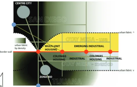
Otay Mesa can be said to embody the irony of the San Diego/Tijuana interface:-- on the one hand, the BIS and the ubiquitous police and military presence are designed to deter visi-tors and urban activity. On the other hand, the presence of permeabilities in the BIS, such as the POEs, create opportunities for exchange that at-tract a vast quantity of visitors and generate large-scale urban activity. The district, which extends 10.5km east-west/4.5km north-south with roughly 3,500 buildable hectares, has developed a physical form that reflects this irony.
Otay Mesa as Urban District Otay Mesa today serves a dual func-tion as the transloading/logistics center for the city’s maquiladoras electronics, automotive and
diver-sified manufacturing sector, and as a general industrial, warehous-ing and manufacturwarehous-ing area. The POE itself has developed into one of North America’s most important land-freight ports, for trucks and containers carrying goods moving into and out of the US. Additionally, thousands of passenger vehicles and pedestrians use the POE to cross the border daily.
Despite this intensity of activity, no commercial center exists, and the urban activity has a distinctly “pass-through” feel to it. A small number of strip-mall-like structures provide services and lodging for millions of POE users, and these facilities, such as they are, are dwarfed by the in-frastructure works and impervious surfaces that surround them. On the Mexican side, hundreds of ad hoc tianguis (informal open air markets) densely arrayed over a few kilome-ters, sandwiched between factories and residential neighborhoods, pro-vide goods and services to border-crossers. Development programs which occupy the preponderance of the site include:-- (i) walls and the POE customs checkpoints required by the state security apparatus; (ii) globalized trade and production fa-cilities, including logistics
establish-ments, maquiladoras-related and general industrial plants and asso-ciated transportation, parking, and container yards7; (iii) minimal hous-ing for workers in these facilities; and (iv) other facilities deemed inap-propriate for more desirable districts, such as waste disposal, landfills, yonkes (automobile and equipment graveyards), prisons and a Depart-ment of Homeland Security detention center.
Tijuana neighborhoods like Ejido Chilpancingo and Las Torres, come right up to the BIS, while San Diego appears to pull back from it, leaving behind it a “no-man’s land” reserved for the urban detritus of unwanted and unpopular programs, security functions, and the barest, and most utilitarian, possible form of industrial development8.
7 Over the last 15 or so years 1.2 million square meters (13.2 million square feet) in leasable industrial real estate has been constructed and occupied on the mesa, Grubb & Ellis Research (2007),
Indus-trial Market Trends San Diego, Second
Quarter.
8 Teddy Cruz characterizes this “no-man’s land” in the following way: “a scarred landscape inhabited only by an army of... paramilitary operations.” He argues that, in this context, only the wall is permanent, with everything else
com-Otay Mesa’s form contrasts marked-ly with the situation at the other POE, between the neighborhoods of San Ysidro and Zona Norte, to the west of the site, which developed before the BIS. There, on both sides of the border, comparatively dynamic tran-sit and pedestrian-oriented commu-nities host a rich and colorful array of planned and unplanned round-the-clock activity in developed blocks (Cruz, 2002). Instead of tianguis and insubstantial strip malls, commercial activities in the compactly scaled neighborhoods are concentrated in traditional buildings, in shopping ar-cades, and in a popular urban outlet mall. Here, the BIS was retrofitted on seized land and inserted between de-veloped programs. The inserted wall segments create an uneasy visual contrast with their surroundings, but the communities on either side ap-pear to have remained integral, sim-ply shifting their spatial structure to accommodate the imposition.
prising “transient nomadic settlements with... buildings which act as scaffolds for change, infrastructures habitually transformed by the overlapping of transi-tory programs, avoiding rigid program-matic and typological envelopes in favor of multiplying their potential as stages for activity” (Cruz, 1999, 43).
Otay Mesa’s Future
For its part, SANDAG, and the City of San Diego recognize the importance of Otay Mesa, as (i) an economically vital node in global supply chains and therefore a local center for job growth, and (ii) as one of the last districts with substantial tracts of undeveloped land, in a metropolitan area desperately short of housing. It has thus initiated a planning pro-cess, ongoing as of this writing, that calls for at least 15,000 new hous-ing units with 55,000 new residents and industrial space that will even-tually host more than 43,000 new jobs (e.g., City of San Diego, 2006; SANDAG, 2006). But, to date, this planning process has not addressed the BIS and its impact on urban form. Nor has it addressed what manner of urban community, as opposed to merely a workshop and dormitory, it would like to see develop at Otay Mesa.
Beyond the BIS, the globalized econ-omy, and the issues that arise from them, local decisionmakers must also address considerations of cul-tural diversity and the nature of form-making in an ethnically segregated but, perhaps, hybridizing city (Dear, 2003). Dear characterized San Diego/Tijuana as a “convergence
field” for hybridities, and nowhere is the more the case than Otay Mesa, whose workers, factory owners and managers, and POE users mirror the diversity of San Diego/Tijuana’s pri-mary cultural groupings.
However, this notion of a city of di-visions, hybridizing as they perhaps are, is not a simple one. As previ-ously noted, the divisions are sym-bolized by the BIS, not reflected in the neighborhoods partitioned by it. The wall may be a symbol of division, but it actually divides nothing tan-gible:-- anybody it might conceivably keep out or in is already present on either side of it. Herzog (2003) ar-gued that the fabric of San Diego and Tijuana, is, on either side of the wall, fractured into seven ecologies, which coexist uneasily:-- (i) global factory zones; (ii) transnational consumer spaces; (iii) global tourism districts; (iv) post-NAFTA neighborhoods (liv-ing zones for workers segregated by social class and ethnicity); (v) transnational community places that facilitate public gathering and “where trade and exchange are valued above defense and security;” (vi) spaces/ neighborhoods of conflict, including the wall and its adjacencies; and (vii) “invented connections” where “op-portunistic and transient” forms of
urbanism facilitate exchange. In this context, one can argue that Otay Mesa today is, at once, a global factory zone, a space of conflict and, by virtue of the POE’s presence, a place for informal and unintended ex-change. San Diego plans for it to be-come, in parts, a global factory zone, a globalized consumer space and a post-NAFTA neighborhood. The Fed-eral government seems to see it pri-marily as a field of conflict, best left to the security apparatus. Neither the present reality nor the articulated vi-sions of two active agents -- the cen-tral government and the locality, each manoeuvring to arrange the district’s future -- permit the mesa to become a place where coexistence and, ulti-mately, hybridization, of San Diego/ Tijuana’s internal divisions are fa-cilitated. This is despite, or, perhaps, because of, its physical and symbolic position on the wall.
The Prisoner’s Dilemma
One can argue that Otay Mesa’s physical form today is the product of agents negotiating with each other through the process of building and developing land in proximity to one another:-- (i) the security-preoc-cupied Federal government, whose formal vision appears to be limited to
the BIS and the design of the POEs, and (ii) the locality, with its centrifu-gal collection of local governments, community groups and private-sec-tor interests, which must negotiate around the BIS and their own appre-hensions about the border “no-man’s land” to build an urban neighborhood (and not merely a collection of park-ing lots and warehouses). This latter agent appears to lack, at present, a form-based vision of what might be the end result of their negotiation. The interaction of these two agents may very well be characterized as a type of asymmetric, non-coop-erative, normal form game:-- local officials adjust their plans based on ever-changing directives about wall construction and real estate specu-lators (who are indifferent to an exit through permitted development or through forced sale to the central state) buy up parcels ahead of land-use decisions (Jackson, 2004). One might very well believe that the most likely outcome to this game will see both agents bound in a prisoners’ dilemma. Barring intervention from a third, external agent, both parties likely will end up with a future Otay Mesa that simply exacerbates the stark realities of the present and their respective concerns about it:-- the Federal government will still perceive
a security risk and the locality will have to contend with more impervi-ous surface without achieving any real urbanism.
That third agent, may, conceivably, be the environment and advocates for its conservation:-- a BIS that, increasingly, disrupts regional hy-drology and destroys habitats (e.g., California Coastal Commission CD-063-03, 2003); settlement patterns that have already strained the wa-tershed and airshed to their respec-tive breaking points (e.g., Kopinak, Bajaras, 2002; Michel, 2000; Pez-zoli, 2000; Sklair, 2000; others); a shortage of drinkable water (Walker, 2004); no less than eight Superfund sites9, and ever-increasing commu-tation times for workers and idling times for emission-generating trucks at the POEs (e.g., Kazimi et al, 2006). Using SANDAG’s conservative Otay Mesa land-use strategy, forecasted increases in population, employment and freight traffic may place unac-ceptable strains on regional transpor-tation and social services resources, industrial waste handling capacity and, more critically, on sewage and water resources. Resource imposed 9 US Environmental Protection Agency (2007), Region 9 Superfund Site da-tabase: http://www.epa.gov/region09/ waste/sfund/superfundsites.html.
constraints may change the rules and outcomes of the game.
Urban form in Otay Mesa emerges out of interactions between the cen-tral government, the locality and the environment, but the mechanisms of that interaction may lack the capac-ity to achieve a result any of these agents would find acceptable. This thesis seeks to better characterize what an outcome acceptable to all of the active agents might entail and to propose an urban design vision plan for achieving that outcome.
STATEMENT OF PROBLEM
This thesis proposes to challenge the status quo at Otay Mesa, by propos-ing an alternative long-term urban design strategy for its transforma-tion. Extant urban systems, including hydrology, landscape, transportation and security, are studied, redefined and restructured as interdependent systems, using state-of-the-art tech-nologies and creative design inter-ventions, with the aim of redeveloping them into a composite infrastructural framework that will host an effective matrix for the development of livable and attractive neighborhoods.
recon-ceived as multifunctional, culturally-inclusive and environmentally sus-tainable urban communities which may coexist with, instead of retreat-ing from, the BIS. Thus restructured, Otay Mesa may become a district that more effectively addresses the requirements -- both implicit and ex-plicit -- of the central state and of the locality, with appropriate consider-ation for environmental quality. Existing site systems, including the BIS, are leveraged in these new infra-structural growth frameworks, rather than assumed away or eliminated10. Conservation and recycling of water resources, industrial by-products, travel times, energy expended in in-dustrial supply chains, and existing buildings are also considered. The “Conceptual map” on the right illustrates the relationship between urban systems and the three agents imposing requirements on the site; the likely, contradictory, outcomes of those requirements, if applied in iso-lation, are given at the bottom. In summary, this investigation or “vision plan” seeks to address the following
questions:--10 The eventual retirement and closure of the Brown Field airport is assumed.
1) What is a physical expression of urban form in Otay Mesa that simul-taneously accommodates frequently conflicting national, local and envi-ronmental intentions for the site? 2) How may man-made infrastruc-tures and natural site systems be
exploited, restructured and interlaced to facilitate the redevelopment of the site?
3) What design interventions will improve the physical and social con-nections between San Diego and Tijuana, and support these
connec-tions by developing a new activity center at Otay Mesa?
4) What will life be like in the neigh-borhoods that will emerge from this redevelopment?
FUSION SPACE
EMPIRE INTERESTS LOCAL CONCERNS CONSERVATION CONCERNS BORDER LAND BIS/ THREAT/ FORTRESS/ ARMED CAMP/ PASS-THROUGH/
“no man’s land”
FACTORY/ LOGISTICS CENTER/ DORMITORY/ EXCHANGE HUB/ DUMP urban systems HABITAT CON-SERVATION/ RESTORATION/ IMPROVEMENT OF HYDROLOGIC HEALTH CONCEPTUAL MAP
VISION
PLAN
reCONTEXT
address
:node in empire
:node in city
:node in nature
:contended node
:node in crisis
ADDRESS
Otay Mesa exists simultaneously as an urban node in three contexts:-- (i) empire: at the respective frontiers of the US and Mexico; at an impor-tant juncture in the global system of production, consumption and trade; and on a supply chain for electron-ics, automobiles and other products for the global market;
(ii) city: at the border interface be-tween two large municipalities, San Diego and Tijuana, which, together, and counting their respective hinter-lands, comprise the twenty-first larg-est metropolitan area in the Wlarg-estern Hemisphere1, with an estimated 2007 population of 4.7 million2; and (iii) environment: in a coastal sage scrub habitat range; on a sandstone/ claystone plateau; and at a topo-graphical highpoint between the Ti-juana-Alamar River Watershed which covers 453,250 hectares, and the Otay River Watershed, which covers 41,440 hectares3.
1 World Gazetteer (2007), http://world-gazetteer.com/
2 CONAPO (2005), SANDAG (2006). 3 Project Clean Water (2007), http:/pro-jectcleanwater.org
This chapter investigates each con-text, and evaluates their implications for the site.
:NODE IN EMPIRE
In this investigation, “empire” refers simultaneously to two phenomena:-- the hard, traditional empires of nation states, in this case the United States and Mexico, and the fluid state space of post-industrial globalization, as that term is used by Hardt and Negri in Empire (2000). It may be argued that both senses of the term apply here. As Barber (1995) described it, the US, of which San Diego/Tijuana is a frontier node, is both a hard power, economically and militarily, and the dominant member in a network of “soft power” in the Hardt and Negri sense, economically, politically and socially. These two types of “em-pire” have frequently been in conflict on Otay Mesa.
Border City - Traditional Sense If one was to maximize the distance from Washington DC and Mexico City to any single point within the respective continental borders of the US and Mexico, one would arrive at San Diego/Tijuana.
In many respects, San Diego/Tijuana
is a frontier city in the old, hard sense of “empire.” Many decisions affect-ing the lives of the people who live there are made by distal agents:-- few major companies are based there; large tracts of land and infrastruc-ture are directly administered by their respective central governments; and San Diego contains a large military garrison. Both of them receive large numbers of in-migrants:-- people who come in search of jobs, educa-tional opportunities, better weather or just to escape from their respec-tive national heartlands. Many in-migrants come to Tijuana in order to facilitate their immigration to the US. Both have ethnic mixes, cultures and resident lifestyles that are heavily in-fluenced by the other. And both of them have attracted heavy-handed responses from their respective gov-ernments when they have been per-ceived to host threats to the safety of their respective states4.
Production Node - New Sense Despite its status as a frontier city in the traditional sense of “empire,” San Diego/Tijuana plays a reasonably im-portant role as a production node in 4 e.g., the afore referenced Operation Gatekeeper for San Diego; Luis Perez (2007), “Mexico Sends in Army to Re-take Tijuana,” Chicago-Sun Times, Jan-uary 4 for Tijuana.
the globalized system of advanced capitalism:-- in the Hardt and Negri sense of “empire.” As King (2004) noted, concepts of core and periph-ery may, under some circumstances, become inverted, with cities that are peripheral from a political perspective having core or at least less peripheral status, from an economic perspec-tive. These two roles have, however, proven to be a source of tension for the city.
Globalized Production in the City Cities with active production bases need to cultivate and sustain the following urban conditions:-- (i) ad-equate space for manufacturers and their supporting services; (ii) infra-structure for the inward and outward transportation access required by these companies for their trade and employees; (iii) housing, services and transportation for a large base of skilled and affordable workers; and (iv) an attractive, dynamic urban environment, with a discernible and interesting identity, for the workers, their managers and, presumably, their customers.
San Diego/Tijuana has been able to offer most of these conditions, in-cluding a large complement of
indus-trial real estate5. On the whole, with some stalling in the late 1990s, San Diego/Tijuana has been on the re-ceiving end of manufacturing capac-ity in the post-industrial restructuring of the global economy6, assisted by the presence of a high proportion of skilled, educated manufacturing and technology workers, the lack of an established union presence and rela-tively lower wages.
Important production sectors in-clude consumer and office electron-ics, telecommunications equipment, automobiles, medical equipment, business services/foundry outsourc-ing, pharmaceuticals, capital equip-5 San Diego/Tijuana has approximately 16.1 million m2 of industrial space (Grubb & Ellis market reports, San Di-ego, 3Q 2006) and only 3.1 million m2 in R&D space and 6.4 million in com-mercial office space. By comparison, Greater Boston, which has a comparable population of 4.6 million, provides 10.8 million m2 in industrial space, with a stress on warehousing, 5.1 million m2 in R&D space and 15.6 million m2 in office space, emphasizing San Diego’s dependence on manufacturing.
6 e.g., James Gerber, Jorge Carillo (2002), Are Tijuana’s and Mexicali’s
Ma-quiladora Plants Competitive? The Fu-ture of Manufacturing in Baja California,
briefing paper. San Diego, CA: Forum Fronterizo.
ment, biotech, semiconductors and recreational equipment. In the past, shipbuilding, avionics and defense manufacturing were also important, but these sectors have declined sig-nificantly in recent decades.
Two important sectors -- electronics and automotive manufacturing and assembly -- rely on the maquiladoras system of dual factories:-- plants in Tijuana provide relatively labor-inten-sive assembly and component fabri-cation, while twin plants in San Diego complete the manufacturing process using components shipped across the border. The finished goods are then shipped from San Diego to US markets or returned to Mexico, tax-free, for export to foreign markets. Tijuana-based manufacturing is now centered on the Mexican side of the Otay Mesa district, where factories owned by multi-national corpora-tions employ approximately 175,000 workers in over 4.1 million square meters of industrial space7:-- one of 7 Ayuntamiento de Tijuana, Instituto Municipal de Planeácion (2006). Work-ers produce automobiles, consumer electronics and personal computers for employers like Toyota, Hyundai, Kojima, Sony, Sanyo and Gateway. A majority of television sets and pick-up trucks sold in the US are manufactured in Tijuana.
the most important industrial con-centrations in North America. On the US side, plants are located in Otay Mesa and other industrial districts. The local manufacturing sector has continued to expand in value, despite the emergence of China, India and other Asian countries as low-cost production locations and despite a sharp contraction in 1999 to 2002. Gerber and Carillo (2002) found, for example, that despite losing some 80,000 industrial jobs in less com-petitive maquiladoras sectors, most value-added jobs were retained and that the sector as a whole remained highly competitive. By 2004 the sec-tor was firmly rebounding toward its pre-adjustment levels (e.g., Lindquist, 2004). Recently, a new trend has started to emerge in Tijuana, with the arrival locally of new automobile manufacturing and assembly plants, namely Toyota (2005) and, ironically, leading Chinese carmakers in 2006 and 2007. The reasons for the re-gion’s continued competitiveness as a production node for certain types of capital-intensive heavy industry are complex and outside of the scope of this writing, but it does appear to be based on factors that are unlikely to change for the foreseeable future, provided infrastructure and
educa-tional investments occur at a pace comparable to the region’s principal Asian competitors (Gerber, Carillo, 2002; Curry, 2000; Erie, Nathan, 2000; others).
Otay Mesa’s situation with respect seaports and other major trade infra-structures, is illustrated in the map on the following page.
Otay Mesa as Production Node Local planners are intensely aware of the need for public investment in Otay Mesa and other such areas. Soden, Olmedo, McElroy (2004) argued that the US-Mexican border zone, when a recipient of adequate trade infra-structure investment, is a national competitive asset, combining read-ily available land with large pools of skilled, well-educated and relatively low-cost labor. Once developed, the border interface region, they argued, will enable the US to slow its rate of job loss to China, India and other developing countries. Erie (2003) addressed the infrastructure require-ments for further industrialization of the San Diego/Tijuana region, con-cluding that state-supported invest-ment in hard infrastructure could ef-fectively catalyze an acceleration of growth in the region’s manufacturing sector. He noted that industries like
km 10 20 30 40 N
underlying satellite image from Google Ear
extrapolated based on data from the Asociación de Maquiladora de Tijuana (AIM), the Consejo Nacional de la Industria Maquiladora de Exportacion (CNIME) and Maquila Properties, Inc
US$/mth m2 and airports to highways and rail
sys-tems” (Erie, 2003, 8).
Erie and Nathan (2000) suggested that San Diego in general, and Otay Mesa in particular, require an ad-ditional US$4 to $5 billion a year in infrastructure, including a more so-phisticated contract manufacturing base and world-class supply chain logistics management facilities, to remain competitive.
Otay Mesa’s role as a production node was first discussed at a con-electronics, which predominate in
San Diego/Tijuana have extremely high rates of cargo generation, and concluded that the transition to technologically-oriented “next gen-eration” industries does not obviate or reduce the need for development of heavy trade infrastructure. He wrote,
“Given such logistics innovations as supply-chain management in global pro-duction and delivery systems, regional competitiveness depends upon provid-ing a seamless multimodal transporta-tion network that efficiently links ports
TIJUANA INDUSTRIAL EMPLOYMENT/REAL ESTATE ABSORPTION
TIJUANA INDUSTRIAL REAL ESTATE VACANCY DIAGRAM OF BORDER/FREIGHT INFRASTRUCTURE
based on data from SANDAG, 2006 based on data from SANDAG, 2006
based on data from SANDAG, 2006
ference of industrialists and planners held late in 1985, called by legislators to obtain consensus on disposition of the site, on the back of the open-ing of the second POE, annexation by San Diego of some 1,800 hectares, construction of a sewer line and the permitting of a 200 hectare Otay In-ternational City free trade zone at the POE (County of San Diego, 1985). Competitive proposals had begun to emerge for non-industrial uses, including demands from the security apparatus as well as lobbies for pris-ons, landfills, open space and even a grand prix race track.
There appeared at the time to be little real understanding among planners or the business community about what would eventually become the true source of the district’s com-parative advantage:-- its potential as a complementary production and lo-gistics platform for the maquiladoras industry and exploitation of the site’s proximity to Mexico and the POE8. The conference attendees seemed more concerned about their per-8 At the time there were only approxi-mately 80,000 maquiladoras industrial workers in all of northern Mexico, versus over a million and a half today.
ANNUAL NORTHBOUND FREIGHT by type/unit passing through Otay Mesa POE
US$ VALUE OF OTAY MESA INTERNATIONAL TRADE
Containers and tr
ucks, circulating on a 24/7 cycle, are a ubiquitous feature of Otay Mesa.
far right aerial imager
y from United States Geological Sur
vey
ception of a competitive threat from Tijuana’s incipient maquiladoras sector to San Diego job growth po-tential, and their perceived need for San Diego to free up large quantities of low-cost industrial real estate as a employer-retention incentive.
In the 1985 consensus, develop-ment would focus on low cost, large floorplate factory buildings, 5,000 to 10,000 square meters in size (Coun-ty of San Diego, 1985). Other ame-nities would be kept at a minimum in order to control costs. One partici-pant said,
“...distribution, administrative, qual-ity control, some test equipment... you might very well see a restaurant. Truck servicing and a service station are likely. A motel is possible as well as freight for-warders and custom house brokerages. Only the infrastructure is missing now” (County of San Diego, 1985, 31). Global versus National Empires Even this minimalist development vision, which may, as previously noted, have been based on mistaken views about the district’s true value in global supply chains, was met with opposition from the traditional “hard” empire, which wished to preserve its prerogatives to treat Otay Mesa as a frontier border security outpost.
Fi-nancier Joseph Smith was quoted as saying,
“Small ideas start like the image prob-lem alluded to. Here we are trying to sell Otay Mesa and in the meantime the Border Patrol.. is out showing a horror slide show. The statements they made were really unbelievable. They contin-ued to show that slide show for probably three months before we got it pulled. It was misleading and absolutely absurd. There are a lot of things that people are fighting us on every inch of the way.... we are not asking for a free ride. We are just asking for people to get off our back because we don’t need to carry a dead load” (County of San Diego, 1985, 38). A similar conflict later developed between the City of San Diego and multi-national corporations, on the one hand, and the security appara-tus, on the other, over the re-opening of freight rail into the area (Lindquist, 2004). Security officials from Wash-ington DC feared that international ter-rorists or even future local insurgents would exploit the rail to carry weap-ons of mass destruction to major population centers in the US interior. In the end, the conflict was resolved in favor of the municipal authorities, and the rail link was opened.
This tension, between the security apparatus of Otay Mesa and the
per-DIAGRAM OF URBAN CONTEXT
OTAY MESA SATELLITE IMAGE
ception of the municipalities and the representatives of global corpora-tions, has persisted over the last two decades. This contest will undoubt-edly continue to inform Otay Mesa’s development into the future.
Infrastructure Constraints
At present, lacking the trade infra-structure sought by multi-national corporations and municipal officials since 1985, the current Otay Mesa POE and a second proposed one to its west, connect mixed-use residen-tial and industrial neighborhoods of Tijuana with mono-functional indus-trial/warehouse areas on the San Di-ego side with highly congested truck and passenger vehicle roads. Com-muters and others require private cars to navigate these crossings, and private automobiles are unaffordable luxuries for many Tijuanense and San Diegans9.
This lack of access options for work-ers to reach their jobs and a short-age of accessible affordable hous-ing are increashous-ing problems. Worker housing is effectively unaffordable in many neighborhoods on the US side. On the Mexican side, worker 9 Household car ownership in the neigh-boring San Diego district of San Ysidro is only approximately 60% (Cruz, 2002).
housing, most of which is located in the colonias populares (informal squatter settlements), is deteriorat-ing as settlements sprawl further and further away from public transit sys-tems, increasingly to dangerous hill-side neighborhoods without access to basic services such as water and power. The average commutation times to plants on the Mexican side, from the outer settlements of Tijuana, can take up to one to two hours, for workers without cars. Average com-mutation times to the US can take up to two to four hours each way.10 Proposed new border restrictions and expansion of the BIS promise to further exacerbate these commutes. Economically speaking, border wait times result in US$4.2 billion in lost annual output, and the loss of over 42,000 jobs on the US side11. These excessive wait times and the associ-ated economic costs are a condition that the region’s primary economic competitors in Asia do not have to face. The lack of proximal worker housing is yet another competitive constraint:-- while manufacturing wages in Tijuana are generally com-10 SANDAG (2006). Economic Impacts
of Wait Times at the San Diego-Baja Cal-ifornia Border, Final Report. San Diego,
CA: SANDAG. 11 Ibid.
petitive with those of Asia (Gerber, Carillo, 2002), especially given San Diego/Tijuana’s proximity to markets, per capita public investment in work-er housing and public infrastructure are reported by local officials to lag those Asian alternatives.
Consequences of Globalization In 2006, the Museum of Contempo-rary Art, San Diego, curated an exhi-bition on the border, called “Strange New World” (Museum of Contempo-rary Art San Diego, 2006). The cata-log included the following commen-tary on the status quo: “The city itself is delineated by the border, a nine-teenth century political construct, but its clash of social, economic, and cultural boundaries is a product of the twenty-first century” (118). The catalog went on to say:
“The social and economic reality of the Tijuana/San Diego border... can be de-scribed as the perfect outcome of the consumerist society that New Realist artworks sought to concretize; it is a place ruled and regulated by the assem-bly and distribution – and, importantly, the resulting waste – of products made for an increasingly homogenous global consumer. Since the 1960s, the border region at once has been shaped by and has adapted to industrial import-export assembly factories, or maquiladoras, that have created an imbalanced
physi-cal and social landscape simultaneously poised between the purported moder-nity of industry and its toxic side effect” (223).
Rem Koolhaas described the signifi-cance for San Diego/Tijuana urban form of the border area’s role as a globalized production area in the fol-lowing way, with particular respect to what he has alternately termed the “catastrophic urbanism” and “trans-frontier urbanization” of the city: “The economic disparity between the US and Mexico is higher than that between any two neighboring countries in the world. One of the results -- a new kind of intra-urban arbitrage -- is abetting the formation of huge new industrial-urban settlements... producing some of the most startling new patterns of coloniza-tion and capital accumulacoloniza-tion in America today... Physical development today can increasingly follow purely economic, statutory and trade itineraries to pro-duce new territorial objects free of the usual historico-cultural unity, identity or grounding. As a result, border territory is now prime real estate, and settlement patterns are being profoundly altered as a result: infrastructure, investment and populations are migrating in droves, set-ting into motion what may be the domi-nant form of con-urbanization over the next decades: border states. These new organizations are nonetheless bound to share the same natural ecologies and
Herzog (2000) went on to argue that San Diego and Tijuana share “inter-active circuits” (6):-- trade, labor migration and global manufacturing systems. Together, these systems share “a common landscape of in-terwoven settlement patterns, hy-drological and biological spheres, and complex environmental stresses that accompany the massive eco-nomic and demographic transfor-mation of the borderlands” (7). In this transformation cities blend into “single functional spaces or trans-frontier metropolitan regions. These new transfrontier metropolises are beginning to build, or at least think about, crossborder infrastructure (new bridges, airports, mass transit lines, shared activity spaces, shared sewage treatment facilities), cement-ing the physical form of these cross-national urban structures” (7). A different view is taken by Teddy Cruz and other scholars, who argued that the areas separated by the bor-der are functionally different, but that they work together (or fail to work together) to produce the whole of the city. Rodriguez (1992) described what he perceived to be differences between the two cities:
“Tijuana and San Diego are not in the same historical time zone. Tijuana is The nature of the relationships
be-tween such paired cities may change over time:
“Integration of border cities is to be con-ceived off as the process of getting more and more involved in each other’s com-munity business. It is not necessary to think of a complete integration (fusion) when only steps of material and orga-nizational nature bring the two neighbor cities together. Physical infrastructure (new bridges and roads) will reconnect both settlements. Social interaction may follow when people of both sides have social contacts with people and ameni-ties in the partner city” (Buursink, 2002, 19).
Ford (2005) and Herzog (1997), both local scholars, go further than Buursink with particular respect to San Diego/Tijuana. They appear to argue that the two cities are not just “paired” but rather are function-ally, one city. That one city, they are argue, is more correctly described as being divided in ways other than the border, such as Herzog’s seven ecologies (cited in the Introduction) and Ford’s geomorphological clas-sifications by which he proposed to divide the city’s functions and socio-logical groups into the topographies they respectively inhabit (such as the coastal plain, the inland mesa and the valleys and mountains).
in respect of San Diego and Tijuana neighborhoods are shown in maps in the following pages.
This section describes the relation-ship between San Diego and Tijuana and the issues that concern their re-spective governments and planners, in the context of this history. Semiotic Nature of the Border Zone Border cities, of which San Diego/Ti-juana is, for many, the quintessential example, have started to feature in the literature of urban planning and geography as a distinct phenome-non. Buursink (2002) defined these border cities in the following way: (i) cities dependent on the border for its existence, at least to some extent, possibly isolated from other national cities by distance or geography; (ii) cities located at points at which routes cross borders, where people and goods enter and leave;
(iii) cities that differ in physical ap-pearance, particular with respect to streets and building types; and (iv) cities that are peripheral, located far away from national cores and main cities.
reservoirs of resources” (Koolhaas, 2001).
This final dimension to the globaliza-tion of San Diego/Tijuana is critical:-- ultimately, the viability of the city as a production node is constrained by ecological systems and their capac-ity. Koolhaas suggested that this constraint is pressing on San Diego/ Tijuana as a border city.
:NODE IN CITY
Until recent decades, San Diego and Tijuana may be characterized as economically and socially-related dual cities connected by roads and, at various points a history, a border check point (Buursink, 2002). Dur-ing this period, the mesa was settled by various cultural groups and was the site of conflicts between those groups (see historical diagram on the following pages). Over time, the two cities grew to fill the agrar-ian area between them, to the west of the mountains and to the east of the Tijuana River estuary (see his-torical maps, below). Finally, in the 1990s, with Otay Mesa only partially developed, the fluctuating interface line between the two municipalities was hardened into a physical border-line. Otay Mesa’s current situation
1 km
N poised at the beginning of an industrial
age, a Dickensian city with palm streets. San Diego is a postindustrial city of high impact plastic and despair diets. And palm trees. San Diego faces west, looks resolutely out to sea. Tijuana stares north, as toward the future. San Diego is the future -- secular, soulless. San Diego is the past, guarding its quality of life. Ti-juana is the future... Taken together as one, Tijuana and San Diego form the most fascinating new city in the world, a city of world-class irony” (Rodriguez, 2002, 84, 106).
Michael Dear (2003), commenting
directly on the border interface it-self, said that it comprises of a set of spaces characterized by “fear, vio-lence, hatred and intense, energetic hope” for a more redeeming future. These spaces act, through a socio-logical processes, to produce what he termed “plural and particular cos-mopolitans” (10); in other words, the workers and residents of San Diego/ Tijuana, subjected to the hybridiz-ing Anglo/Latino/global environment of their city, become non-elite cos-mopolitans, with a correspondingly higher sophistication of discourse
and, he argued, artistic expression. This hybrid, cosmopolitan culture may be seen in the city’s vernacular arts, which range from architecture and indigenous systems of urban-ism12, to music (e.g., the Norteño and Nortec traditions) and visual arts13, to agricultural innovation, cui-sine, and linguistic forms.
The Planning of Otay Mesa
Kada and Kiy (2004) conducted an assessment of planning conditions in the border interface zone and studied the mechanisms and processes by which residents in that zone, in ei-ther city, manage their communities. Instead of focusing on geographical 12 e.g.: Uliss and LeClerk (1999) char-acterized the area’s design innovations as a “laboritorio de la postmodernidad”; and Lawrence Herzog (1999) described in detail the characteristics of San Diego/ Tijuana’s hybrid architecture.
13 e.g.: Michael Dear (2003) document-ed artistic innovation in the San Diego/ Tijuana region; internationally regarded designers and artists such as Torolab and Estudio Teddy Cruz have emerged from the region; and several major exhi-bitions on local art, music and urbanism have recently been held in the two cities including the 2006 Habitando la Frontera exhibition in Tijuana and the 2006 Extra-no Nuevo Mundo (“Strange New World”) exhibition in San Diego.
divisions, they classified the border zone as a set of constituencies or “community assets” in categories that cut across the border, such as businesses/manufacturers and their associations; regional educational institutions; churches/religious in-stitutions; NGOs/community/ethnic organizations; elite cultural institu-tions; government; and homeowner associations (particularly important in Mexico); et cetera.
They argued that these groups bine and coordinate, or fail to com-bine and coordinate, in different ways, to address regional planning concerns that effect their constituen-cies. These concerns, they argue, consist of a set of issues that, for the most part, influence urban form and management on both sides of the border: (i) long border waits; (ii) ris-ing housris-ing costs, particularly short-falls in affordable/worker housing; (iii) urban sprawl/ecosystem impacts of sprawl, particularly in respect of hydrology and habitat; (iv) siting of manufacturing/assembly facilities near underserved communities; (v) inadequate sewage and waste facili-ties and their inequitable concentra-tion at or near the border interface; (vi) limitations in worker childcare; and, primarily in a Mexican context, OTAY MESA NEIGHBORHOOD CONTEXT