HAL Id: halshs-01070622
https://halshs.archives-ouvertes.fr/halshs-01070622
Submitted on 14 Mar 2019
HAL is a multi-disciplinary open access
archive for the deposit and dissemination of sci-entific research documents, whether they are pub-lished or not. The documents may come from teaching and research institutions in France or abroad, or from public or private research centers.
L’archive ouverte pluridisciplinaire HAL, est destinée au dépôt et à la diffusion de documents scientifiques de niveau recherche, publiés ou non, émanant des établissements d’enseignement et de recherche français ou étrangers, des laboratoires publics ou privés.
Mediterranean settlement patterns
Sébastien Oliveau, Yoann Doignon
To cite this version:
Sébastien Oliveau, Yoann Doignon. Ever closer to the water. Recent developments in Mediterranean settlement patterns. South-East European Journal of Political Science, 2014, II (3). �halshs-01070622�
3
C
ONTENTS
EDITORIAL
Roberta PACE, Alain PARANT, Demographic dynamics and population issues in the Mediterranean. . . . . . 5
ARTICLES Maria CARELLA, Alain PARANT, Demographic trends and challenges in the Mediterranean. . . . . . 10
Yoann DOIGNON, Sébastien OLIVEAU, Ever closer to the water. Recent developments in Mediterranean settlement patterns. . . . . . .22
Farida LAOUDJ CHEKRAOUI, Spatial differences of mortality: social and medical factors. . . .31
Carlo MACCHERONI, Diverging tendencies by age in sex differentials in mortality in Italy. . . . .. . . .42
Sorin MITULESCU, Child policy in Romania. Does Romania follow a Mediterranean model? . . . ..59
Thaís Garcia PEREIRO, Roberta PACE, Marriage structures and family policy in the Mediterranean. . . .. . . .75
Gil BELLIS, Matrimonial practices, population genetic structures and public health in the Mediterranean Region . . . . . .86
Khalid ELJIM, Alain PARANT, Migration of Mediterranean nationals within the Mediterranean Region.. . . .97
Corrado BONIFAZI, Massimiliano CRISCI, Cristiano MARINI, Anna SANMARTIN ORTI The Balkans and the EU: recent trends of a Mediterranean migration . . . ..110
ESSAY Giuseppe CAMPESI, Frontex, the Euro-Mediterranean border and the paradoxes of humanitarian rhetoric. . . .126
4
BOOK REVIEWS
Marisa A. VALLERI, Roberta PACE, Stefania GIRONE (eds.), Il Mediterraneo: uno studio e una passione. Scritti in
onore di Luigi Di Comite
(Sara GRUBANOV BOSKOVIC) . . . .135
Giuseppe CAMPESI, La detenzione amministrativa degli stranieri. Storia, Diritto, Politica
(Valeria VERDOLINI) . . . .137
FONDAZIONE MIGRANTES - Delfina LICATA (ed.), Rapporto italiani nel mondo 2014
(Nadia MIGNOLLI) . . . . . . 139
Corrado BONIFAZI, L’Italia delle migrazioni
(Maria CARELLA). . . ... . . .141
Filomena RACIOPPI, Giulia RIVELLINI (eds.), Applied Demography. La Demografia per le aziende e la governance
locale (Thaís GARCIA PEREIRO). . . . . . .. . ..143
INTERVIEW EVENT
Filip STANCIU, Geopolitical and Security Effects of the Ukrainian Crisis in Europe . . . 146
SIGNALS
Thaís GARCIA PEREIRO. . . .. . . 148
NOTES ON CONTRIBUTORS . . . . . . . . . 153
Mandatory submission guidelines . . . 158
English edition for Italian authors by Laura Peci, technical expert of the Italian National Institute of Statistics – ISTAT (Italy)
22
Ever closer to the water. Recent developments in Mediterranean
settlement patterns
1Sébastien OLIVEAU
University of Nice, Sophia Antipolis, Avignon University, Aix Marseille University, CNRS, UMR ESPACE 7300, DEMOMED
Yoann DOIGNON
University of Nice, Sophia Antipolis, Avignon University, Aix Marseille University, CNRS, UMR ESPACE 7300 LAMES UMR 7305, DEMOMED
Abstract: Since 1950, the density of the population has increased in all Mediterranean countries,
especially in countries on the southern shore, where it has multiplied more than six-fold in 60 years. The Mediterranean is becoming dense, but the spatial distribution of people remains very heterogeneous. The general model is a decreasing gradient from the coast to the hinterland. However, we should qualify this observation with the territories studied. Using fine-scale mapping, we propose the regionalisation of the population densities in the Mediterranean. This map highlights the former structuring role of port cities and the differing role of mountains in the immediate hinterland. Recent changes observed emphasise the coastal development of populations and urbanisation. Influenced by tourism, especially, but also migration, the Mediterranean population has been profoundly remodelled. These changes raise the question of the sustainability of Mediterranean territories when understood from an ecological perspective.
Keywords: Population, density, Mediterranean, urbanisation
1. INTRODUCTION
The areas bordering the Mediterranean share common natural (climate, vegetation etc.) and social features (monotheism, growing of vines and olives etc) that give the area a certain unity. However, in terms of the spatial distribution of people there are significant contrasts that deserve to be explored. We propose discussing this diversity in human densities around the Mediterranean here.
To make this study consistent, we limited it to coastal countries by the sea, including, however, Serbia, Macedonia, Jordan and Portugal. A brief description of these countries will firstly highlight the diversity of situations and their temporal dynamics. A more detailed mapping of densities will complete this first table. Its commentary will be restricted to the first few hundred kilometres. In fact several countries cover large areas and include areas that are not objectively Mediterranean (France and Algeria, for example).
We will then consider the specific link between density and urbanisation. In recent decades, the Mediterranean, like other areas, has experienced (and still is today) significant changes in its human habitat (in quantity and quality). We would like to highlight the role of tourism in these changes in particular.
We will endeavour to discuss the issues related to these areas regardless of whether said issues are natural or anthropogenic. Indeed, with more than 340 million people sharing this common mother, population issues are as important (and often related) as geopolitical issues, which take centre stage too often.
2. HIGHLY CONTRASTING DENSITIES
The population around the Mediterranean is very unevenly distributed. The coastal deserts of Libya and Egypt are succeeded by the high densities in Palestine. Thus figures range from less than 4 inhabitants per square kilometre to more than 660 (figure 1). These contrasts were already present in ancient times and, in the middle of the twentieth century, Palestine was already the most densely populated country (150 inhabitants/km²) and Libya the least dense (less than 1 inhabitant/km²).
1 This work is part of the SoDeMoMed project, financed by ANR Transmed (ANR-12-TMED-0005). The authors are grateful to
23
Figure 1. Evolution of the population density in the major Mediterranean countries since 1950
Authors: Oliveau S., Doignon Y., 2014. Source: World Population Prospects, 2013.
Today, the average density of the Mediterranean countries exceeds 100 inhabitants/km². 70% of these countries have a density between 60 and 130 inhabitants/km². Only Libya (3.6 inhabitants/km²), Algeria (15.3 inhabitants/km²) and Montenegro (45 inhabitants/km²) fall below this range. Conversely, some countries exceed 130 inhabitants/km²: Italy (200 inhabitants/km²), Israel (335 inhabitants/km²), Lebanon (417 inhabitants/km²) and the Palestinian Territories (666 inhabitants/km²). In addition, in the Mediterranean there are a number of city-states with densities that are much higher. This represents the urban character of their territory. Thus, note the presence of Monaco, recognised as the most densely populated country in the world with almost 25,000 inhabitants/km², Gibraltar (4.900 inhabitants/km²), the Vatican (1,816 inhabitants/km²), Malta (1,344 inhabitants/km²) and San Marino (506 inhabitants/km²).
We will also mention that although densities have increased in the last 65 years, the order of countries has not been changed fundamentally. Overall, the density of the countries on the northern shore of the Mediterranean has multiplied by 1.5 while for the countries on the southern shore the density has multiplied by 3. Although the evolution of densities on the North shore is fairly homogeneous, it is much less so for the South shore. We should note, however, that Algeria and Libya have not experienced this type of growth, and some countries have experienced more rapid increases. Jordan has increased its density 14-fold (from 5 to 72 inhabitants/km²) and Syria more than 6-14-fold. Lebanon and Palestine have increased their density by a little more than 4-fold, but they went much higher. Israel's case is unique, since its density has increased more than 6-fold in the same time, for reasons including migration.
At the time of its creation, Israel was populated almost exclusively by immigration (aliya). Since 1948, over 2 and a half million Jews have immigrated to this country1. The creation of Israel also gave birth to a
Palestinian diaspora. 90% of Palestinian refugees live in the neighbouring countries of Israel and the Palestinian Territories, including Lebanon and Jordan. This population growth has reinforced what has been called the "war of the cradles", that is to say the high fertility of the Jewish and Palestinian populations,
1
William BERTHOMIERE, Kamel DORAI, “Israël-Palestine: populations, migrations, Etat(s)”, in BORNE, Dominique SCHEIBLING, Jacques (dir.), La Méditerranée, Hachette, 2002, pp.195-215.
24
supported by an ideology aiming to increase their demographic weight to win the battle in the number of men. This race resulted in an increase in population density, reinforced by the small size of the countries concerned.
All other countries on the South shore have seen at least a 3-fold increase in density, which is double that of the countries on the North shore. This differing north/south growth is mainly due to demographic transition. When the crude mortality rate is low and the crude birth rate remains high, the natural growth rate increases sharply. Northern countries experienced this increase in population during the nineteenth and early twentieth centuries. The demographic transition in the countries on the South shore began later. Fertility only declined from the second half of the twentieth century1. The increase in population is contemporaneous
with this decline. There is now a convergence of the densities of most countries on the South shore towards those on the North shore. This movement is considered by demographic projections anticipating that by 2025 there will be a significant increase in the population mainly in the Mediterranean countries on the South shore. At the same time, some countries on the North shore might see their populations decrease2.
Regional geography densities seem to be emerging. The countries on the North shore, from Spain to Turkey, are characterised by average densities (except Italy) and tend to converge. The Middle East, as we have noted, seems to be racing towards density instead. Finally, the South shore remains sparse at state level: the Maghreb and Mashreq countries do not exceed 80 inhabitants/km². However, they are characterised by strong internal inequalities. For example, Egypt has a population density of 78 inhabitants/km2, but regional
situations vary widely from the Saharan regions (where the density is close to 1 inhabitant/km²) in the Nile valley (where densities often exceed 1.500 inhabitants/km²)3. A discourse on population densities in the
Mediterranean at State level is not satisfactory. Subnational level seems much more appropriate for this type of study.
We'll begin by recalling some general points. For this, we used the subnational scale for all the Mediterranean countries mentioned above. We have harmonised the administrative levels chosen in each country to maximise the comparability of administrative units between countries4. The data is from central
statistical offices; it comes from the general census of the population, or their updates by marital status, or surveys. Let us first recall that more than 340 million people live within 250 kilometres of the Mediterranean. This distance was chosen to try to limit the consideration of geographical logic that would not be the responsibility of the study area (hinterland too far away from the Mediterranean Sea, Atlantic and Sahara area).
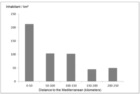
Of some 340 million people, 80% live within 150 kilometres and 45% within 50 kilometres of the coast or near the shore. A more detailed analysis (only possible for some countries) shows that the proportions are even more pronounced, with 25 % of the population living within 25 kilometres of the shore. Figure 2 shows the density level in 50 km sections. We can see that the density decreases rapidly as we move away from the Mediterranean. From over 210 inhabitants/km² less than 50 kilometres away, the number drops to 50 inhabitants/km² for the band located between 200 and 250 kilometres from the sea.
1
Joseph Alfred GRINBLAT, “L’évolution de la fécondité dans le monde depuis 1965 et ses conséquences”, Mondes en développement, Vol. 2, No. 142, 2008, pp.13-22.
2
Isabelle ATTANE, Youssef, COURBAGE, La démographie en Méditerranée. Situation et projetions, Les fascicules du Plan Bleu, n° 11, Economica, 2001, p. 249.
3
Daniel NOIN, Abdelkader SID AHMED, Geneviève DECROIX, Population et perspectives de développement du monde arabe, Editions UNESCO, Paris, 2000.
4
For this application, we calculated the average number of inhabitants in each administrative level for each country. Then we set a threshold, here 500 000 inhabitants. In each country, we choose the administrative level closest to this threshold to harmonise sub-national meshes around the Mediterranean as best as possible. In France, for example, it was the departments (populated by an average of 600 000) that were selected. This method and its results are presented in detail in Doignon & Oliveau (2014).
25
These statistics highlight the location of the population following a rapidly decreasing gradient from the coast to the hinterland. However, this general pattern of population distribution does not apply to all the Mediterranean coasts. It is then necessary to qualify it according to territories. From a map presented below, we propose exploring the logic at work in more detail.
Figure 2. Population density according to distance from the Mediterranean
Authors: Oliveau S., Doignon Y., 2014. Source: National Central Office of Statistics, 2013.
3. COMMON LOGICAL DISTRIBUTION OF PEOPLE
The mapped data is that produced by the SEDAC1 under the GPW project (Gridded Population of
the World - http://sedac.ciesin.columbia.edu/data/collection/gpw-v3). It is based on local censuses or United Nations data from 2000 and data projected for 2015. The administrative level chosen in each country is as fine as possible, according to the availability of data. For the countries of Southern Europe (Portugal, Spain, France, Italy), communes are used, unlike Turkey or the Maghreb countries where provinces, wilayas or regions are represented. Despite this lack of harmonisation in the level of representation, it still remains possible to draw a picture of the population distribution in the Mediterranean. For Serbia, Bosnia-Herzegovina and Montenegro, we complemented the GPW data with data from the geographic information system at the demographic Observatory of the Mediterranean, DemoMed (http://demomed.org). Data processing for mapping based on the statistical distribution of density values, which approximately follows a geometric progression. The result is a unique map of population densities at a fine scale for the entire Mediterranean basin (map 1).
Firstly, what we can see from viewing the map showing densities in the Mediterranean is the alternation over short distances of areas full of people and those devoid of them. The Mediterranean area is often characterised by stark contrasts; the distribution of the population is no exception to this.
1
This data is distributed by the Socioeconomic Data and Applications Center (SEDAC), located at the Center for International Earth Science Information Network (CIESIN) of Columbia University, NY. http://sedac.ciesin.columbia.edu.
26
Map 1. The population density in the Mediterranean
We can nevertheless observe a number of regularities, which certainly suffer exceptions, but which can provide an overview on which we will build to propose a regionalisation.
Firstly, as we have already pointed out, coastlines are generally marked by high densities, while the hinterlands are less populated. Libya and Egypt, and to a lesser extent the Balkans, are an exception. These continuous densities on the coast are added to local density peaks that correspond to the ports that bring the Mediterranean together. Even sparsely populated coasts have these areas of concentration related to maritime activities: Split, the second largest Croatian town; Benghazi and Tripoli in Libya, Alexandria and Port-Said in Egypt. On the other hand, finally, river corridors form ribbons that seem to stretch from the coast to the interior, against the current. The Nile and Rhône are obvious, but a more careful look highlights the structuring effects of the Po, Tiber, Ebro, Guadalquivir and the Jordan.
Conversely, the hinterlands are empty, with the exception of the Balkans, where the situation is more complicated. We should say that the mountains and the Sahara form a big part of the hinterland. Regarding the Sahara, the dry climate has prohibited human settlement outside of some oases (the Nile valley is the only visible trace on the map). Mountains play a more ambiguous role. They can constitute difficult to reach areas with a harsh climate that have limited their settlement, as is the case on the north shore for the Southern Alps, the Apennines, the Dinaric Alps and the Pindus mountains. Others have often served as a refuge and are thus more populated. This is the case in the South with the Atlas and the Rif mountains, which are certainly less populated than the Moroccan and Algerian coasts but are not devoid of inhabitants. Similarly, Mount Lebanon has long provided shelter for the various communities persecuted in the region.
This geographic logic arises from clearly identified regional groupings. Firstly let's compare the two Mediterranean basins. The western basin shows the clearest coastal/hinterland difference. Within this basin, the south shore is marked by the presence of the Sahara that forced people to the coasts. In the north, the mountains have very low densities (less than 30 inhabitants/km² in the southern French Alps) while in the
27
south, they can exceed 200 inhabitants/km², as is the case in Kabylia. The north shore is also distinguished by the urbanisation of the coastline beyond the ports (discussed below), as well as the presence of significant and numerous water courses that extend the densities to the hinterland.
The situation of the eastern basin of the Mediterranean is more disparate. The south shore is a desert coast: the Sahara desert is literally on the shore, and only port cities pierce these areas with near-zero densities. Only one river disturbs this organisation the Nile. In fact almost all of the population is focused in this region. The Middle East resembles the south of the western basin: a dense coastline with a desert hinterland. This is no longer the Sahara, but the Arabian Desert. In Jordan, the Jordan River and its tributaries are visible through the higher densities that accompany them. Turkey has an average population density (92 inhabitants/km²) spread fairly evenly over the territory. Coastal areas (Mediterranean and the Black Sea) are indeed slightly more populous than inland areas, but we do not find outright opposition between coastal and inland areas. Only the Istanbul region is distinguished by higher densities.
The Balkan Peninsula is much less dense with an organisation that must be observed in detail to be understood. The coastlines are narrow here, the reliefs are hilly (Dinaric Alps, Pindus Mountains) and dominate the hinterland making movement difficult (Prévélakis, 1994). Thus, Greece is 80% mountains. When there are inland plains (Croatia, Serbia), densities go back up. None of the countries, with the exception of Greece, have a coastal capital. Podgorica, Tirana and Zagreb are located on the plains, Ljubljana and Sarajevo in the mountains. According to Olivier Deslondes1 "the Balkan Peninsula is more continental
than the Mediterranean". Greece aside, the Balkans indeed seem more focused on their inland plains. The densities of the eastern coast of the Adriatic are in stark contrast to those on the west coast.
4. COASTAL DEVELOPMENT AND URBANISATION
Urbanisation should be given special attention in the study of the unequal distribution of densities. Indeed, density and urbanisation have a complex relationship, and one or the other must be compared, especially around the Mediterranean. Let's remember that cities are born from the accumulation of populations and can therefore be seen as resulting from high densities2. However, in other cases, the city may
also be the venue for the crystallisation of the habitat in the context of low population.
These different scenarios are found at Mediterranean level. An example would be the cities in the Nile Delta, which owe their development to the delta's agricultural fertility, which has allowed the development of the population. In contrast, but not so far, the city of Tripoli, Libya, is a centre of densities that does not rely on strong rural densities but owes its existence to its role as a port.
We must briefly discuss the role of port cities; one of the characteristics of the Mediterranean area is that it is built around a shared or dominated sea (mare nostrum) where trade (particularly commercial) has united all the shores since ancient times. Thus port cities form the nodes of a network of high densities around the sea. From Barcelona to Alexandria, the list is long of major port cities that exceed 500,000 inhabitants is a long one, including, in the North, (Montpellier, Marseille, Nice, Genoa, Rome, Naples, Palermo, Bari, Athens, Istanbul, Izmir, Antalya, Lattakia, Beirut, Gaza, Port Said, Damietta) or, in the South, (Valencia, Malaga, Nador, Oran, Algiers, Annaba, Tunis, Tripoli, Benghazi). 8 of the 21 bordering countries have also chosen to make it their capital. For the record, let's remember that one city, although sparsely populated, has also remained independent and is today the densest country in the world: Monaco.
1
Olivier DESLONDES, , “Les Balkans”, in BORNE, Dominique, SCHEIBLING, Jacques (dir.), La Méditerranée, Hachette, 2002, pp.176-194.
2
Paul, BAIROCH, Cities and Economic Development From the Dawn of History to the Present, Translated by Christopher Braider, Chicago University of Chicago Press, 1988.
28
In addition to this ancient urbanisation related to port positions and/or the richness of the hinterland, there is, in many regions, a new dynamic, linked to contemporary social changes: tourism and the ageing of the population. We are witnessing the population moving towards the coast in many countries. We have already mentioned that population densities in areas bordering the Mediterranean have increased much more in the last 25 years than in the rest of the country (see the maps proposed by SEDAC GPW for 1990 and 2015 http://sedac. ciesin.columbia.edu/data/collection/gpw-v3). Coastal development has resulted in a significant growth in existing cities as well as the development of new cities. This is linked firstly to the attractiveness of existing large cities and to increasing their weight. We should not overlook the impact of tourism -including international, which is prevalent in almost all countries. Finally, some countries (particularly France and Spain) are experiencing a particular form of internal migration related to retiring workers choosing to move to enjoy the coastal lifestyle. What is generally called heliotropism but which would rather be "haliotropism". These three factors all explain why, everywhere, there is significant coastal urbanisation compared to that of the immediate hinterlands.
The phenomenon of tourism in the Mediterranean is quite old and has been important for many years in some cities such as Venice, Rome, Barcelona, Athens and Istanbul. The tourist frequentation of the coastlines of Catalonia, Camargue to the Gulf of Genoa, north of Sicily, and Lebanon is quite old, in line with the high density of the population in these areas. Gradually, the perception of the sea has changed in the collective imagination. It is now considered a recreational area among others. The Mediterranean is the first beneficiary and tourism has become the dominant activity1.
Mediterranean cities gradually became more and more attractive spaces until the advent of mass tourism, which has profoundly changed habits and landscapes. New tourist sights developed from the 1960s. Resorts were created from small towns, even ex nihilo, to accommodate mass beach tourism. This phenomenon was first found in France and on the eastern coast of Spain. With the development of air transport, this new tourism was rapidly exported all around the Mediterranean. The latter is now dotted with resorts whose population can increase more than 4-fold during high season: Hammamet, Nabeul and Kelibia near Tunis, Cap Bon, Bizerte, the Gulf of Gabes, the resort near Antalya, the Florentine and Venetian coast, the entire western coast of Turkey, the Israeli coast, the Greek islands (including Crete), the northernmost tip of Morocco, Corsica and Sardinia. Tourism is also strongly encouraged in the South, because its economic impact is very important, especially in countries such as Morocco, Tunisia, Egypt, Turkey and Israel. Nevertheless, the flow supplied by the basin's richest populations is concentrated in the European countries on the north shore.
We should note that the bipolar-beach waterfront model no longer has the appeal it once had and we see a growing interest in cultural heritage. In addition, the model of long summer holidays is quickly developing into short and off-season breaks. Cities are increasingly preferred, especially because they offer a better quality of service throughout the year. These recent developments have lead to renewed interest in cities like Naples and Marseille, which were not really tourist cities before.
Finally, extending the life of the populations of the countries of the northern shore, combined with comfortable living conditions (retirees), means the elderly in these countries can enjoy the end of their lives in a different way. Migration of people aged 60 or over is also remodelling the coastline. In the search of an enjoyable life, retirees in developed countries tend to head to the Mediterranean coast, particularly to their cities that combine sun, sea and services. These internal migrations, which are also sometimes international and now extend to Morocco, are not inconsequential. The installation of non-native populations and the development of second homes has increased pressure on host areas tremendously. In addition to the ecological stresses that they cause (we'll come back to this), they have a significant impact on real estate by increasing pressure on land. People of working age face competition for property, which is even stiffer when
1
29
retirees arrive with a large amount of capital, while working people often live in areas quite weak economically1.
This coastal urbanisation has important implications and raises many issues. Human pressure on the natural environment, the structural weaknesses of urbanised coastal areas or future climate change, coastal densities and their particular shape (concentration) raise questions about the consequences of these rapid and recent changes.
5. CONCLUSION: WHAT ARE THE CHALLENGES?
The high population densities of the Mediterranean are not without risk to the environment, which is already subject to some pretty harsh weather conditions. In turn, this environment poses the question of the sustainability of human settlements. Long history (we can only think of the Romans) has showed that the influence of societies on the territory has fluctuated over time based on the techniques and means used to "tame" the environment.
The recent densification and urbanisation of Mediterranean areas has increased the pressure on an already fragile environment. The issue of water is at the heart of the Mediterranean ecosystem. The summers are dry while spring and autumn can see violent rains falling. Man has transformed, sometimes recklessly, the Mediterranean environment, resulting in a worsening of the already serious consequences of climate phenomena. Roads built in the valley bottoms make the soil impermeable thus increasing the violence of runoffs. Road and rail facilities are blocking the removal of excess water. When a rainfall event occurs, floods then become catastrophic. They are also especially so as the population at risk has also increased sharply. Thus, in a developed country like France, floods in the Mediterranean region cause several deaths each year (without addressing the financial cost of these events even when they are not so tragic).
On the other hand, the high concentration of people also requires a large supply of water for drinking, as well as for recreation. The continuous and rapid densification of these areas has resulted in a considerable increase in demand for water, which reaches its peak during the dry summer season where tourists add to resident populations. Even the water supply has become a major issue, which exceeds the boundaries of States. We are referring of course to the situation in the Middle East where negotiations around the use of the waters of the Jordan are at the heart of international discussions. Spain, in a less dramatic manner, has also faced these kinds of issues and has responded with large-scale water projects.
Once used, the water is then discarded and needs to be treated so as not to pollute. Processing conditions vary widely from one country to another. Countries of the European Union, from this point of view, are ahead of others, even if there is still work to do. Water management is made more difficult as the populations present vary greatly from one period of the year to the next. This requires infrastructure sized for peak periods, the costs and management of which will be borne by the resident population.
This anthropic pressure is also taken into account by governments trying to protect the natural environment. Development of the Integrated Coastal Zone Management (ICZM) protocol is the most obvious evidence of this. However, although the majority of countries bordering the Mediterranean have adopted this protocol, its application is still in its infancy and there are few visible consequences2.
1
This is one of the paradoxes of tourism: it may seem like a good method of development, particularly at national level by providing cash and by the pressure it puts on the need to develop infrastructure, it generally proves unproductive locally as it disrupts the labour market and thus the entire production chain. It is indeed a service economy which employs mainly people with few qualifications earning low wages that are still higher than in other production sectors (agricultural or industrial) with which it competes. This creates an imbalance ultimately hindering the development of the regions concerned.
2
Lisa, ERNOUL, Between Camargue and the Gediz Delta: reflections on the transfer of integrated management models for coastal zones, Ph.D. Thesis, University of Aix-Marseille, unpublished, 2014.
30
We will conclude this very brief overview of the issues of Mediterranean densities referring to the challenges that the Mediterranean basin will face. In all probability, densities will continue to increase and the pressure of the human population on the natural environment will not decrease. In addition, global climate change will have specific consequences in the Mediterranean. Rising temperatures could already transform a part of the ecosystem, but certainly changes in rainfall will affect the Mediterranean basin the most. The increase in the annual and interannual irregularity of rainfall could have consequences that are still hard to imagine, but that we must master quickly. Increases in droughts or heatwaves in number and duration, associated with more frequent and severe floods, would render populations more vulnerable. In a context where poverty remains one of the main characteristics of the inhabitants on the southern and eastern shores of the Mediterranean, the picture that emerges is not very encouraging. However, since ancient times, the populations and territories of the Mediterranean basin have showed their resilience, as evidenced by the many amenities and sometimes ancient infrastructure constituting the specific landscape of this area (terraces and aqueducts for example).
Bibliography
ATTANE, Isabelle, COURBAGE, Youssef, La démographie en Méditerranée. Situation et projetions, Les fascicules du Plan Bleu, n° 11, Economica, 2001, 249 p.
BAIROCH, Paul, Cities and Economic Development From the Dawn of History to the Present, Translated by Christopher Braider, Chicago University of Chicago Press, 1988, 596 p.
BERTHOMIERE, William, DORAI, Kamel, “Israël-Palestine: populations, migrations, Etat(s)”, in BORNE, Dominique, SCHEIBLING, Jacques (dir.), La Méditerranée, Hachette, 2002, pp.195-215.
BETHEMONT, Jacques, Géographie de la Méditerranée, Paris, A. Colin, Coll. U, 2000, 313 p.
DESLONDES, Olivier, “Les Balkans”, in BORNE, Dominique, SCHEIBLING, Jacques (dir.), La
Méditerranée, Hachette, 2002, pp.176-194.
DOIGNON, Yoann, OLIVEAU, Sébastien, “Territorial grids in the Mediterranean: space versus population”, Bollettino dell’Associazione Italiana di Cartografia, 2014.
ERNOUL, Lisa, Between Camargue and the Gediz Delta: reflections on the transfer of integrated management models
for coastal zones, Ph.D. Thesis, University of Aix-Marseille, unpublished, 266 p., 2014.
GRINBLAT, Joseph Alfred, “L’évolution de la fécondité dans le monde depuis 1965 et ses conséquences”,
Mondes en développement, Vol. 2, No. 142, 2008, pp.13-22.
NOIN, Daniel, SID AHMED, Abdelkader, DECROIX, Geneviève, Population et perspectives de développement du
monde arabe, Editions UNESCO, Paris, 2000.
PREVELAKIS, George, Les Balkans, cultures et géopolitique, Nathan, Paris, 1994, 191 p.
UNITED NATIONS, Department of Economic and Social Affairs, Population Division, World Population
Prospects The 2012 Revision, CD-ROM Edition, 2013.
Centre for International Earth Science Information Network (CIESIN)/Columbia University, and International Centre for Tropical Agriculture (CIAT), Gridded Population of the World, Version 3
(GPWv3) Population Density Grid, Future Estimates. Palisades, NY: NASA Socioeconomic Data and