Sub-inertial variability in the Cretan Sea from the M3A buoy
15
0
0
Texte intégral
(2)
(4)
(5)
(6)
(7)
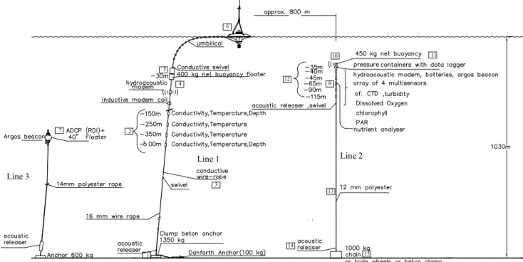
Figure


+7


Documents relatifs
Per tal de poder fer una comparació de les pràctiques abans i després de la formació i veure la repercussió d’aquesta a la millora de la higiene de mans, també
En el següent fragment de llengua es mostra una conversa entre la professora i A1 per donar resposta a la pregunta cinc de l’activitat dels xiprers: Per al cas general de n files
La transición a la democracia que se intentó llevar en Egipto quedó frustrada en el momento que el brazo militar no quiso despojarse de sus privilegios para entregarlos al
L’objectiu principal és introduir l’art i el procés de creació artística de forma permanent dins l’escola, mitjançant la construcció d’un estudi artístic
L’ inconformisme i la necessitat d’un canvi en la nostra societat, em van dur a estudiar més a fons tot el tema de la meditació, actualment sóc estudiant d’últim curs
Paraules clau—Oracle Database, base de dades relacional, sistemes distribuïts, sistemes de replicació, DataGuard, màquines virtuals, entorn de replicació, arquitectura
Si bien Salem’s Lot parece haber perdido también parte de esta iconografía más clásica, en lo que se refiere a la aparición del lobo como criatura afín al
también disfruto cuando una parte de la clase opina algo mientras la otra opina lo contrario y debatimos mientras llegamos a una conclusión acerca del poema.”; “he
