HAL Id: insu-00716159
https://hal-insu.archives-ouvertes.fr/insu-00716159
Submitted on 10 Jul 2012
HAL is a multi-disciplinary open access
archive for the deposit and dissemination of
sci-entific research documents, whether they are
pub-lished or not. The documents may come from
teaching and research institutions in France or
abroad, or from public or private research centers.
L’archive ouverte pluridisciplinaire HAL, est
destinée au dépôt et à la diffusion de documents
scientifiques de niveau recherche, publiés ou non,
émanant des établissements d’enseignement et de
recherche français ou étrangers, des laboratoires
publics ou privés.
The Late Jurassic oblique collisional orogen of SW
Japan. New structural data and synthesis
Michel Faure, Martial Caridroit, Jacques Charvet
To cite this version:
Michel Faure, Martial Caridroit, Jacques Charvet. The Late Jurassic oblique collisional orogen of SW
Japan. New structural data and synthesis. Tectonics, American Geophysical Union (AGU), 1986, 5
(7), pp.1089-114. �10.1029/TC005i007p01089�. �insu-00716159�
TECTONICS, VOL. 5, NO. 7, PAGES 1089-1114, DECEMBER 1986
THE LATE JURASSIC OBLIQUE COLLISIONAL OROGEN OF SW JAPAN. NEW STRUCTURAL DATA AND SYNTHESIS
Michel Faure, Martial Caridroit, and Jacques Charvet
DSpartement des Sciences de la Terre, Universit8 d'OrlSans, France
Abstract. The structural
configuration of SW Japan mainly reflects a late Jurassic-early Cretaceous orogeny. The region is divided into an inner belt and an outer belt, on the Japan sea and
Pacific ocean sides respectively, by a
strike-slip fault, the Median Tectonic Line (MTL). Both consist of a series of stacked nappes. The inner belt is divided into a Jurassic olistostrome known as the Tanba zone and a hinterland area
comprising continental Triassic-Jurassic sediments. The Tanba zone is sliced into two units: a lower one with late Jurassic matrix and Triassic-early Jurassic radiolarite olistoliths, tectonically
overthrust by an upper unit comprising an
olistostrome with middle Jurassic matrix and blocks which include late Paleozoic limestone, basic lava, and radiolarite. The Tanba zone is overthrust by a Paleozoic nappe complex derived from the hinterland. The basal sole of the nappe corresponds to a peculiar unit called the ultra-Tanba zone. In the Chugoku area, the hinterland is divided into an upper nappe: the Oga nappe, formed by Permo- Carboniferous limestone and Permian clastic rocks and a lower one: the Sangun-Maizuru nappe, formed by Paleozoic
Copyright 1986
by the American Geophysical Union.
Paper number 6T0398.
0278-7407 / 86 / 006T-0398510. O0
high pressure (HP) metamorphics (the
Sangun schists), the Permian Maizuru
olistostrome, and the dismembered Paleozoic Yakuno ophiolites. In the northern part of SW Japan, the Tanba zone is in faulted contact with the circum- Hida and the Hida zones. The former is interpreted as the equivalent of the Oga and Sangun-Maizuru nappes of the Chugoku domain crushed by post Cretaceous
tectonics. The latter consists of
Paleozoic high temperature (HT)
metamorphic rocks and late Triassic-early
Jurassic granite, locally mylonitized and
covered by early Jurassic sandstone. The outer belt is formed by a superficial nappe similar to the Tanba zone thrust upon a "deep domain" characterized by a synmetamorphic ductile deformation. The "deep domain" is divided into a lower unit, the Oboke unit formed by
continental derived arenites and a Green Schist nappe consisting of oceanic sediments and resedimented ophiolites.The Green Schist nappe overthrusts the Oboke unit under synmetamorphic conditions with an eastward displacement. The two belts are separated by the Ryoke zone which corresponds to the southern part of the Tanba zone affected by a Cretaceous HT metamorphism and sharply cut by the MTL. A geodynamic model is proposed for the Jurassic orogeny of SW Japan assuming that the evolution of the inner and outer belts are linked. In the Late Triassic- Early Jurassic SW Japan is an active
1090
Faure et al.: Late Jurassic Orogen
of SW
Japan
SW
JAPAN
Hida circumHida Z//Sangun
f .Maizuru Z.Oga
NE
t
JAPAN
CENTRAl,
:akami kuma KantoItoigawa -
nbaZ.
Shizuoka F.
Superficial Nappe
reen Schist Nappe
Oboke Unit
Kurosegawa. Sanbosan Z.
Shimanto Z.
200 km
Fig. 1.
Structural map of Japan, except Hokkaido,with emphasis on the late
Jurassic structure.The distinctions
between SW, Central, and NE Japan are
Tertiary
divisions due to the Tanakura and the Itoigawa-Shizuoka faults.
plate margin. The upper plate or South
China block consisted of the hinterland
and the Tanba belt, a forearc basin; the
lower plate consisted of an oceanic area and the South Japan continent. The basic
mechanism of the orogeny is ascribed to
the oblique subduction and collision of the South Japan continent.
INTRODUCTION
The Japanese Islands can be divided into three domains by means of Cretaceous
and younger faults
(Figure 1), namely :
(1) NE Japan north of the Tanakura fault,
(2) Central Japan between the Tanakura and
Itoigawa-Shizuoka
faults,
(3) SW Japan
south of the Itoigawa-Shizuoka fault.This last domain is also divided by a large strike-slip fault, the Median
Tectonic Line, into an inner belt on the Japan Sea side and an outer belt on the
Pacific Ocean side. However, though this
geographic division can be used to
explain the Miocene and younger features
of Japan such as the opening of the Japan Sea, the collision of the Izu peninsula, and the present plate tectonic framework,
it cannot be used to describe older deformations responsible for the
progressive development of the present
Japanese Islands since Paleozoic times.
It is now a widely accepted fact that the pre-Miocene structure of Japan is a result of three main orogenic cycles bounded by regional unconformities (e.g., Kobayashi, 1941; Kimura, 1973; Tanaka and
Nozawa, 1977). From youngest to oldest
they are:1. A Paleogene cycle or Shimanto
orogeny responsible for the deformation
of the outermost zone of SW Japan (the
Shimanto zone), for the reworking by
brittle, superficial and local reverse
faults of the older zones and for a
calca!kaline magmatism related to the subduction of an oceanic plate under the
islands.
2. A Mesozoic cycle equivalent to the
Faure et al.: Late Jurassic Orogen of SW Japan 1091
Kobayashi (1941). It begins in the late
Triassic and ends in the middle
Cretaceous when the nappe structures are sealed in the outer belt by shallow-water Neocomian deposits and in the inner belt by middle to late Cretaceous acidic volcanism or continental Cretaceous deposits or are intruded by late Cretaceous-Paleogene granitoids. The deformation related to this cycle reaches its climax in late Jurassic-early
Cretaceous times with the emplacement of large nappes. It corresponds chrono- logically to the Daebo orogeny of Korea
(e.g., Reedman and Um, 1975) and the
early Yenshan deformations in China
(e.g., Klimetz, 1983).
3. A late Paleozoic-early Triassic
cycle or Akiyoshi orogeny (Kobayashi, 1941) that very little is known about,
since it is largely reworked by the early Yenshan orogeny.
When considering the early Yenshan orogeny, the inner-outer division must not be equated with the inner-outer distinction of the alpine fold belt of Europe where the inner belt is
characterized by intensely deformed metamorphic rocks and the outer belt by more superficial tectonics. The inner- outer division of SW Japan will be used here as it is a convenient division.
The early Yenshan orogeny is not restricted to SW Japan. The Kanto area of
Central Japan (Figure 1, Kimura, 1973;
Tanaka and Nozawa, 1977; Guidi et al.,
1984) is very similar in stratigraphy and
structure to the outer belt of SW Japan. In NE Japan also, the Kitakami and Abukuma massifs can be compared with the Sanbosan zone, the Kurosegawa zone and the Green Schist nappe of SW Japan
(Figure 1, Kimura et al., 1975; Faure,
1985a).
This paper aims to present a new and comprehensive structural map of the Jurassic orogen of Southwest Japan, based on a detailed description of selected key areas and a synthesis of previous works. It then attempts to gather all the available data into a new geodynamic model.
THE GEOLOGICAL STRUCTURE OF THE INNER BELT
General outline
,
The inner belt is classically
subdivided into several zones roughly
trending east-west (Kimura, 1973; Tanaka and Nozawa, 1977). The main subdivisions
considered in this paper are: (1) the
Tanba zone and (2) the hinterland
including all the other zones except the
Ryoke zone. This last one is considered separately, since the post-Jurassic deformation and magmatism are by far predominant. Inside the hinterland there
is a distinction between the Chugoku
domain on one hand and the Hida-circum- Hida domain on the other hand. This distinction is due merely to present geographic conditions, since their
relationships are hidden under the Japan
Sea. In the following the geology of the
Tanba zone, Chugoku domain, and Hida- circum-Hida domain is described with emphasis on Jurassic structure.
The Tanba zone
The Tanba zone is the largest one of SW Japan (Figures 1 and 2) well developed
around Kyoto, i.e., the Tanba area sensu stricto and North of Nagoya, i.e., the Mino area. Recent sedimentological
studies and discoveries of radiolaria fossils in siliceous pelite, chert, and
mudstone (e.g. Yao, 1972; Tanba Belt
Research Group, 1979; Mizutani et al.,
1981) show the importance of the
olistostrome phenomenon. The Tanba zone should be now considered as an area of Jurassic chaotic sedimentation.
Turbidites, diamictites, and
olistostromes are conspicuous facies in the zone, and almost all of the
radiolarian chert, limestone, and basic volcanic are olistoliths. Local but
precise biostratigraphic studies suggest the existence of nappes, for instance, in
the Kyoto area and up to the Japan sea
(Figures 2 and 3; Imoto et al.,
1981;
Ishiga, 1983; Caridroit et al., 1984,1985) or North of Nagoya(Kano, 1979) and
perhaps south of the circum-Hida zone
(Adachi and Kojima 1983).
As the Kyoto area is the best known, it is given here as an example. There, the lowermost unit observed in the core of the anticlines consists of an olistostrome whose siliceous siltstone and black shale parts of the matrix yield late Jurassic radiolaria. The olistoliths are exclusively well bedded cherts ranging from middle Triassic to early
Jurassic in age (Isozaki and Matsuda,
1980). The lowermost member of the
apparent sequence is often a large middle Triassic bedded chert mass but, it is probably a huge olistolith. Thus the base of the sequence is unknown.
1092
Faure et al.: Late Jurassic Orogen of SW Japan
•,1••
Hida
Zone
Circum Hida Zone
granit
,.•/•_(;• •r• •, ,,• _
Tsuvama
Kamigori
•/•
•==•u•-
Maizuru'
•• Mai
[•
zulu
Na
Zo
lasud Akiyo• early Mesozoic molassenba Zone
Ry oke Zone
Uni'
reen Schist Nappe
Superficial Nappe
Kurosegawa-Sanbosan
Zone
Shimanto
Zone
50krn
Fig. 2. Schematic map of the Late Jurassic orogen in SW Japan. The Cretaceous
and younger rocks have been omitted.
Carboniferous to early Permian red-brown chert, Permian hyaloclastite, and basic lava sometimes having pillow structures, dated by fusulina found in the
interlayered limestone. These rocks are overlain by an early to middle Jurassic olistostrome. Permo-Carboniferous and Triassic cherts, Permian basic volcano- clastic rocks, and Permo-Carboniferous limestones are included as olistoliths. The chaotic formation is followed by a sandstone formation characterized by slump structures and turbiditic
alternations. In places, interstratified reworked granite, acidic lava and tuff conglomerates are known. It should also be noted that plagioclase and rock fragments derived from acidic and calcalkaline rocks are conspicuous
(Shimizu et al., 1978). As for the lower
unit, the true stratigraphic succession
is unknown. According to Ishiga (1983),
Permian chert forms the base of the sequence followed by the greenrock of the same age, it is conformably overlain by the early-middle Jurassic olistostrome followed by the turbiditic sandstone. However, Permo-Carboniferous greenrock and chert may also be kilometer-scale
olistoliths reworked into the early to middle Jurassic matrix. Nevertheless, it is clear that early to middle Jurassic black shale, sandy mudstone, tuffaceous shale, and diamictite overlies similar but younger facies demonstrating the existence of at least one late Jurassic tectonic superposition.
Olistostrome and nappe structure were already recognized in the eastern part of
the Tanba area, north of Nagoya (Figure 2) by Kano (1979) on the grounds of
sedimentological studies. The "nappes" consist of kilometer-scale Triassic chert slabs surrounded by olistostromes which are interpreted as collapse structures in front of the advancing nappes. They are synsedimentary gravity-driven structures, assumed to have slid from south to north. The origin of the gravity sliding is thought to be the uplift of the Ryoke zone. This is in apparent contradiction with the nappe motion in the Kyoto area, which is from NW to $E, at least in the late stages. In fact, the two sets of nappes differ in timing and emplacement mechanism. The nappes of the eastern
Tanba zone are early (circa middle to late Jurassic) synsedimentary structures,
Faure et al.: Late Jurassic Orogen of SW Japan 1093
N
INNER
BEL'
MTL
OUTER
BELT
S
PALEOZOIC HINTERLAND
TANBA Z. 'RYOKEZ.IGreenSchistN.
•
t Superficial N
Hida
Sangun-Maizuru Oga
ß
neoge,
nl•
2 •1 / 9
I L• T,'ias
2 4 • : 4 l?
•-[•'6'
I• .T•anbøsan
neoa
...
•
South
Japan
Block
0 50
•-J•
1 Paleozoic
metamorphicsHT
itlOAZONE
HP
Perre,an
schists
SANGLJN
and Permidn olistostrome HAIZURLIk•:t3 nnmetamorphic
Permian rocks•GA
NAPPE
:'::'••• Jurassic
HT schistsolisfostrome
TANBA
RYOKE ZONE••5 mefa-arenlfe
OBOKE
UNIT
Late
Jurassic
turbidire
SANBOSAN
ZONE
K. [retaceo[Js, P Paleogene, I'1 Hiocene
l_dtt.:
E,'e.
faLeOU,
ruth,dre
(,ZUI'tl
GRUP)
[r[:faceous
and younger
voJcani['s
:.:216
Ju,• tip
Schist
6REEN
SEHIST
NAPPE
Fig. 3. General N-S cross section in the upper crust of SW Japan. (A) Neogene and Quaternary deposits, (B) Cretaceous-Tertiary volcanism, (C) Intrusive
granitoids ((K) Cretaceous, (P) Pa!eogene, (M) Miocene), (D) Neocomian molasse in the outer belt, (E) Maestrichtian turbiditic (Izumi group) on the northern side of the MTL, (F) Cretaceous HT metamorphic rocks and anatectic granitoids Ryoke zone, (G) Late Jurassic and Cretaceous-Paleogene turbiditc in the Sanbosan and the Shimanto zones, respectively, (H) Paleozoic HT Hida metamorphics, (I left Paleozoic HP Sangun metamorphics, right serpentinite,
(J) Paleozoic ophiolite (Yakuno complex), (K) Permian Maizuru olistostrome, (L) Oga nappe, left, Late Carboniferous-Middle Permian reefal limestone
facies, right, Late Permian noncalcareous facies, (M) Triassic sandstone, (N)
Jurassic Tanba olistostrome and its extension in the superficial nappe of the
outer belt, (0) Oboke sandstone unit, (P) Green Schist nappes undifferentiated, (Q) Basement of the outer belt (South Japan block)
outcropping in the Kurosegawa zone. The deep crustal structure is from Hada et a1.1982, 6.1 and 7.8 are the layer velocities in kilometers per second.
while the nappes of the Kyoto area are later ones formed after rock induration. Moreover, the sense of displacement of the eastern Tanba zone is not firmly concluded from microtectonic
observations.
West of the Kyoto area, Tanba type facies outcrops in several places,
namely; the Masuda and Kuga (Figures 4, and 7C), Kuse (Figure 6), Kamigori and Wakasa areas, (Figures 5 and 7A; Toyohara
1977; Tanaka,1980; Hayasaka and Hara, 1982; Hayasaka et a1.,1983; Faure and
Caridroit, 1983). They are interpreted
here as tectonic windows inside the
hinterland (Figures 1 and 2) but the two
units of the Kyoto area are not
definitely recognized owing to the small surface of exposure.
Several problems remain with the Tanba zone, among them, the source area of the olistoliths, the environment and
depositional conditions of the siliceous facies, and the nature of the underlying crust. The Tanba zone is generaly
considered by previous workers, to be an oceanic area whose crust has disappeared by subduction under the Hida zone; the sediments were accreted along the Hida-
1094
Faure
et al.: Late Jurassic
Orogen
of SW
Japan
Fig. 4. Structural map of the Kuga-Masuda
area,modified from the 1/50000
geological map of the Nishikigawa area. (A) Liassic molasse, (B) Noncalcareous
Paleozoic rocks of the Oga nappe, (C) HP Sangun
metamorphics,
(D)ribbon
facies, (E left) flysch facies, (E right) Jurassic olistostrome, (F)Southern
part of the Tanba
olistostrome transformed
into biotite-sillimanite schist by
the HT Ryoke metamorphism,
(G) Cretaceous
Ryoke migmatite granite, (H) Late
Cretaceous
granite, (I) Mineral and stretching linearion in the Ryoke
metamorphics,
arrows indicating the plunge, (J) Mineral and stretching
lineation in the ribbon rock facies, arrows indicating the sense of shear, (K)
Location of the Jurassic radiolaria in the matrix of the olistostrome, from
Hayasaka et al. (1983).
1981; Hattort,
1982; Hara, 1982; Mizutani
and Hattort,
1983; Hirooka et al.,
1983).
However, those models proposed for the
eastern part of the Tanba zone cannot
account for the Chugoku area.
The source of the Paleozoic
olistoliths
can be easily
found into the
hinterland.
The limestones are probably
derived from the Oga nappe, since they
have the same age and facies. The basic rocks can be provided by the Yakuno
complex or the Carboniferous rocks at the
base of the Oga nappe. This is in
Faure et al.: Late Jurassic Orogen of SW Japan 1095 ribbon 7 labbro Permian green sandstone J6rassic ,listostrome ,peridotire Wakasa Paleozoic ophioli Permian olistostro Fig. 7
flysch
5km ;sic molasse KamigoriFig. 5. Structural map of the Kamigori-Wakasa area,adapted from the 1/50000
geological
maps of Wakasa, Chizu, Sayo, and Kamigori,
(A) Sangun metamorphics,
(B left)
serpentinized peridotite,
(B right)
metagabbro, (C) Paleozoic
ophiolites,
(D) Permian Maizuru olistostrome,
(E)Triassic
molasse,
(F&G)
Ultra Tanba zone, (F) Flysch (Triassic?),
(G) Ribbon rock, (H&I) Tanba zone,
(H) Greenish sandstone, (I)
Jurassic
olistostrome
with Permo-Triassic
olistoliths,
(J) Antiform, (K) Synform, (L)Mineral and stretching lineation
in
the ribbon rock facies arrows indicating the sense of shear.
suggestion that the limestone olistoliths in the eastern part of the Tanba zone
were derived from the circum-Hida zone, which is the extension of the Chugoku
area in our interpretation. Biotite-
sillimanite gneiss, garnet gneiss,
marble, orthoquartzite, granite, quartz porphyry andesite, Permo-Carboniferous limestone are found as pebble in
conglomerate. Isolated heavy minerals as
such as sillimanite, garnet, and
chloritoid are conspicuous in sandstone
(Adachi, 1971; Adachi and Kojima, 1983).
Biotite-sillimanite gneiss provides
Precambrian ages,(circa 1500 and 1700Ma, Shibata, 1979), unknown in the Hida zone
but widespread in Korea and China
(Reedman and Um, 1975; Lee, 1980).
Sandstone in the Tanba zone containsseams of carbonaceous matter (Iijima et al., 1978) or plant fragments (Nishida et al., 1974). Most of this detritus was
provided from the Hida zone where such rock and fossils are recognized.
The cherts are often interpreted as
1096
Faure et al.:
Late Jurassic Orogen of SW Japan
the geodynamic models. However, according to sedimentological and geochemical comparisons with present oceanic siliceous ooze, the Triassic-early
Jurassic Tanba cherts are considered to be deposited in an offshore or marginal
sea environment (Imoto and Fukutomi,
1975; Shimizu and Masuda, 1977; Sugisaki
et al., 1982; Matsumoto and Iijima, 1983).
With reference to the basement problem of the Tanba zone, it is necessary to distinguish between the present basement formed by late Cretaceous-Paleogene
granite, the postorogenic basement and the preorogenic basement. As for the former, it will be discussed with the geodynamic model. As for the latter, there is only one locality in the northern part of the Tanba zone, where pillow lava and basic tuffs are closely associated with middle Triassic-early
Jurassic pelite and chert (Hattori and Yoshimura, 1983). Except this place,
there is no evidence for Mesozoic ophiolite, even reworked in the whole Tanba basin. Thus it is necessary to suppose either that all the oceanic crust has been subducted or that it was very limited in extension and perhaps never existed.
The Hinterland
,,
This is a wide and composite domain, but in terms of the Jurassic orogeny, the characteristic feature is that all the constituent zones of the hinterland suffered to varying degrees the late Paleozoic orogeny and are unconformably overlain by shallow water facies of late
Triassic to middle Jurassic age (Figures l, 2 and 8). Thus during the Jurassic
orogeny the hinterland behaves as an already structured "basement". Since the relationships between the two parts of the hinterland, the Chugoku domain and the Hida-circum-Hida domain are hidden under the Japan sea, both areas are presented separately.
The Chugoku domain. Owing to
widespread extent of the Cretaceous and
younger formations, the Jurassic and older rocks outcrop only by patches. Since this paper discusses the late Jurassic orogeny, Triassic-Jurassic
detrital rocks and their deformation, the stacking of nappes of the Chugoku zone with reference to the late Jurassic structure and the relationships between the Chugoku domain and the Tanba zone are successively presented.
The Triassic-Jurassic molasse facies: The early Mesozoic rocks which form limited outcrops all along the Chugoku
domain, from Maizuru to Akiyoshi (Figures 2, 4, and 6) correspond to the post
orogenic molasse of the Paleozoic cycle. They are shallow water sediments
containing brackish water, lacustrine and deltaic facies; coal seams and plant
fossils are conspicuous (Nakazawa and
Shiki, 1954; Teraoka, 1959; Tanaka and
Nozawa, 1977). The Rhaetic-Liassic flora
is similar to those known in China, Korea
and Sikhore Alin (Kimura, 1980). The
early Jurassic formations of the Chugoku area are correlated with the Kuruma group of the circum-Hida zone upon the base of similar biofacies and lithofacies (Tanaka
and Nozawa, 1977; Yu, 1983).
All these formations are considered to unconformably cover the Paleozoic rocks
(e.g., Kobayashi, 1941; Nakazawa and
Shiki,
1954; Teraoka, 1959; Kimura, 1973).
However, the very unconformity is seldom observed, as it is often hidden by subvertical faults and sometimes has been developed as a thrust plane since it corresponds to a mechanically weak zone. The latter is the case in the Oga area,(Figures 6 and 7B), where the basal
conglomerate and sandstone overlying the Sangun schists suffered a brittle
deformation marked by tension gashes, slickensides, Riedel planes, and crushed zones localized along high-angle reverse faults directed southwestward.
The early Mesozoic rocks are never metamorphosed nor schistosed, but very often they bear the marks of a weak superficial deformation in the form of reverse faults and open folds. In the
Tsuyama area (Kawai, 1958; Mitsuno and Omori, 1964), the Triassic sandstone lies
in the core of overtuned synclines. In
the Oga area (Figure 9), low angle
southward verging brittle shear zones associated with drag folds are
conspicuously observed in the Triassic sandstone overthrusted by the Oga nappe. Moreover, the age of the deformation is not clearly defined, since the early Cretaceous rocks also are sometimes affected by reverse faults, for instance,
in OEa or KamiEori areas (Faure and Caridroit, 1983). North of Tsuyama
(Figure 6) the Sangun metamorphic rocks
thrust up the Miocene conglomerate with avery steep (circa 70 N) reverse fault, (Kawai, 1958; Faure and Caridroit, 1983).
Synsedimentary normal faults are observed in the Maizuru, Oga, and
Faure et al.: Late Jurassic Orogen of SW Japan
1097
+ + + L•a9sic• + + + + + + + + +++++++
+++++++
-I-_
+ + + +
+++ +++ + + + + + + + + + + + + + + + + + ++++++++++ +
+ + + + +++++++++++++
+++++++++++
+ +++
+ + + + + + + + + + + + + + + + + + + + + + P Permian + + + + + SC13iStS.k'i-+++
+++ + +
+ +
+++++ + + + + + + +__
- + +
++
+ +
+++++
+ + +++++
++++
i
+++++
+
+ + + + + +
+
+ + + + + + +--t---C
++
retaceous
++
+++
++• ++
+ ++'
+ ++
++
++
++
++
+.+4• rocks
+ + + + +[ + + •-+• + + + + + +/';i+ + + +'•. + ,["'l•J.t-
+ + + + +.i."1
+ + + + '!"( + +1 + + +. + + + ++ + + +• + J•+
+ +•++++++++
+•.-['7Z-Late
Triassic
+ + + -:
...
:./•.•:•_++++++++++..'.' molasse
+ ++++++!
. :.o.:
:,:'
+ + + t' •',,•1•).'"'"':...::::...'.."'•::.:i'.':T+ + •l•+
•'1:I;•'• '"
:•....'..•::•!.:_:i:-:-'
'"•...'
'..-:'- -'
--
' ; ' ' ' .'
+ +v:.'. ': t..'
• sic • ---- • )listostz•me-•_ +•+•Kuze
g •t• SSCI•i
j st•
• + .+ .,perieo•
•te
+ + + + + + .4- ++ + + + + + PERMIAN Limestone Icareous OGA rocks NAPPE a i+ + +•5km,
hJVvJ
FiE. 6, Structural map of the Oga-Atetsu area, (a) Cretaceous and younger
granite, pyroclastites, and sediments, (b) Liassic molasse, (c) Late Triassic
molasse, (d&e) Oga nappe, (d) Late Permian noncalcareous
facies, (e) Late
Carboniferous-Middle Permian reefal limestone facies,
(f) Permian Sangun
metamorphics,
(g) serpentinized peridotite,( unshaded
g) metagabbro,
(h) Basic
schists into the $anKun metamorphics, (i) Jurassic olistostrome.
Akiyoshi areas at the outcrop and
microscopic scales (Figure 10). These
data fit well with the Triassicdistension inferred in our model. The stack of Paleozoic nappes: The
Chugoku domain has been interpreted
by
early workers as being formed by nappes
and recumbent folding.
Kobayashi (1941)
defined the late Paleozoic Akiyoshiorogeny in the westernmost part and the
late Jurassic-early Cretaceous Oga nappe in the central part. In agreement with
Hase (1964), field surveys in the Kuga-
Masuda area (Figure 4), Kamigori-Wakasa
area (Figure 5) and Oga-Atetsu area
(Figure 6) allows the subdivision of the
Chugoku domain into the Oga nappe, the
Sangun metamorphics, the Yakuno
ophiolite,
and the Maizuru zone. The last
three are not differentiated in Figure 2.
The Oga nappe is the uppermost unit.
It
comprises non metamorphic limestones and
noncalcareous sediments ranging from late Carboniferous to late Permian. The age of
1098
Faure et al.: Late Jurassic Orogen of SW Japan
•
1 molasse
T:Triassic
J:Jurassic
•[•.2 limestone
[:•i!7[!i
3non-calcareous
facies
'•4 peridøtite
HP schistPERMIAN
METAMORPHICS•-15 olistolith
basic Schist (SANGUN)
6 Paleozoic
ophiolite
(YAKUNO)
Permian
olistostrome-
MAIZURU
GROUP
PERMIAN
• 8
OGANAPPE
[L•9
flysch ribbon rock greensandstone olistostrome ULTRA-TANBA ZONEJURASSIC TANBA ZONE
i'!•10
HT
schist
i-•-]11
m
igmatite
EARLY CRETACEOUS
RYOKE ZONE
granite
- LATE
CRETACEOUS-PALEOGENE
Fig. 7. Submeridian
cross
sections,
(A) Kamigori-Wakasa
area, (B) Oga-Atetsu
area, (C) Kuga-Masuda
area. See Figures 4, 5, and & for location.
the Oga nappe is a debated question.
In
the Oga area, the Triassic rocks
unconformably overlie both the Oga nappe
and its substratum of Sangun metamorphic
rocks (Teraoka, 1959; Oto, 1984; Figure
&). However, a deformation surely
occurred between the late Triassic and
middle Cretaceous, since in the Oga and
Atetsu areas the Paleozoic rocks thrust the Triassic sandstone which is folded
and overturned (Figure 9). A two stage
deformation can account for the
contradictory
observations. At first,
between late Permian and late Triassic
times the Oga nappe thrusts the Sangun
metamorphic rocks, then the contact is
covered by the Triassic
deposits and
during the late Jurassic orogeny, the Oga
nappe moves again overthrusting the
Triassic deposits. In discussing the
Jurassic orogeny, there is a need to estimate the amplitude of the Jurassic thrust. It could be a multikilometer scale overthrust of a minimum of lO0 km
assuming a displacement perpendicular
to
the regional
NE-SW trend,
since there is
no room for a root zone before thecircum-Hida zone, or only a limited high
angle thrust.
This second interpretation
is preferred
(Figure 7C) given that in
the Akiyoshi area the Triassic formations
are covering basal contact of the Oga
nappe (Sakamoto, 19&9; Tanaka and Nozawa,
Z977).
As already stated,
the Sangun
metamorphics are relevant to thePaleozoic orogeny; however, they suffered
a reworking during the late Jurassic as
shown by the K-At ages clustering about
260 Ma and 170 Ma (Shibata and Igi, 1969;
Nishimura, 1981; Nishimura et al.,1983).
North of Kamigori (Figures 5 and 7A) the
Sangun metamorphics thrust up the Yakuno
ophiolite developing decameter scale drag
folds. The Yakuno ophiolite in turn thrusts a Permian olistostome called the
Maizuru group (Faure and Caridroit, 1983;
Caridroit
et al.,
1984, 1985). The
Triassic molasse, when it is present, is
always trapped between late subvertical
faults,
so that a Jurassic age for the
thrust cannot be ascertained. The Maizuru group is the lowermost part of the
hinterland stack of nappes, it thrusts up
the Tanba zone by means of a complex
basal sole which is described in the following section.
Faure et al.: Late Jurassic Orogen of SW Japan
1099
[ c [ I • 9 1
Permian
++
++
20 km
•4
/ MeSC
ml7
• 8 •Juras•icmolasse•.Makido
•g.
•.
S•uc•u•a• map o• •he H•da-c•cum-H•da doma•, (•
C•e•aceous
mo•asse, (2• Jurassic mo•asse, (3• •a•y
Neso•o•c •u•a•su g•a•e,
a•ows
•d•ca•g
•he sense o• shea• •o
•he my•o•c
•ac•es, (•
•a•eo•o•c H•da
H• me•amo•ph•cs, (5 •
No•me•amo•ph•c •e•m•a• •oc•s, (5L• •mes•o•e •ac•es o•
0m• a•d ;se, (6• No•me•amo•ph•c S•u•o-Oevo•a•
•oc•s, (7• Ne•amo•ph•c •oc•s
o• •he c•cum-H•da
•o•e,
(•e•
Se•pe••e;
(•gh•
early •a•eo•o•c
me•abas•es sometimes w•h H• assemblages, (•
Jurassic o•s•os•ome
(•a•ba
•o•e•,
(9• •ea•o•
•
•he g•a•e
my•o•e
w•h •he sense o• shea•.
rocks and the Jurassic Tanba zone: It is in the Maizuru zone that the relation-
ships between the Jurassic Tanba zone and
the Paleozoic rocks are the best known(Caridroit
et al.,
1984, 1985). The two
units of the Tanba zone defined in theKyoto area are recognized, but the upper unit is overlain by another one called
the ultra-Tanba zone. Upwards, the cross section is as follows: The early to middle Jurassic olistostrome is covered
by greenish sandstone; it is thrusted
by
NW
SE
Fig. 9.
Deformation of the late Triassic
sandstone, below the Oga nappe near
Oga.1100 Faure et al.: Late Jurassic Orogen of SW Japan
N
Sandstone
and
conglomerate
S black
siltire
Fine grained sands[one50 cm 1 cm
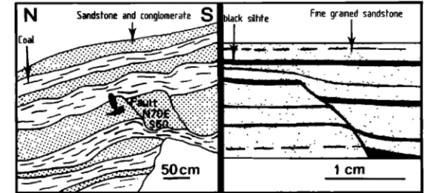
• ,,
Fig. 10. Example of synsedimentary faulting in the Triassic molasse.
a late Permian cherty formation called the "ribbon facies" because chert and pelite form millimeter-scale
alternations. The ribbon facies is
followed by a flyschoid formation assumed to be early Triassic. It is itself
covered by an olistostrome assumed to be early to middle Jurassic since it
resembles the olistostrome of the Tanba upper unit. The ultra-Tanba zone is in turn thrusted along late Permian black pelite belonging to the Maizuru group. The ribbon facies and the flysch are characteristic formations. They have been recorded in the Kuga and Masuda areas
(Figure 4), in the Kamigori and Wakasa
areas (Figure 5), in the Kuze area (Figure
6), and other small places (Figure 2).
The Chugoku area forms in its entirity a vast nappe overlying the Tanba zone. The ultra-Tanba zone appears as the sole of this nappe where almost all strain is concentrated. The bedding surfaces of the flysch are coated by neoformed white micas and chlorite, and the ribbon facies is extensively recrystallized. The initial bedding of the ribbon facies is enhanced by a spaced cleavage formed by alternation of polycrystalline quartz bands and micaceous layers. The same anastomosing cleavage is also observed in the sandy facies around clasts. Pressure solution is obviously the dominant
deformation mechanism as shown by buckled veins normal to the cleavage with
dissolved hinges or pressure shadows around detrital clasts in sandy facies
(Figure !1) and pyrite in siliceous
facies. The ribbon rocks bear a faint mesoscopic mineral amd crenulation linearion trending N60E in the Maizuru area and N80E-NllOE in the Kamigori-
Wakasa and Kuga areas (Figures 4 and 5). In thin section, stretching is marked by
boudinaged and pull-apart clasts. Crystallization of quartz ribbons and pressure shadows is conspicuous along the lineation. Sometimes asymmetric pressure
shadows (Figure 11) and discrete shear
bands directed eastwards are also
observed. The linearion is interpreted as an "a" lineation showing the sense of transport of the hinterland nappe. Such an eastward sense is in agreement with the eastward nappe motion inferred from
microstructures in the outer belt (Faure,
!985b) and with the deformations related to the Jurassic orogeny in the Hida zone; see below.
At the scale of the whole inner belt an eastward nappe displacement is rather
difficult to explain unless by assuming a two stage deformation with an early
ductile eastward motion reworked by a southeastward brittle thrust. As a matter of fact, the present thrust contact is a reworked one, since the whole succession is seldom found except in the Maizuru
area. But the age of reworking is
unknown. This interpretation is in agreement with the deformation sequence observed in the Maizuru area. There southward verging subhorizontal brittle shear zones cut obliquely the foliation
of the ribbon facies and the underlying
Tanba pelites. Though the Tanba rock are
generally undeformed, in places,
especially in the northern windows, a rough cleavage surrounding the clasts in pebbly mudstone underlined by chlorite and sericite is observed. An E-W preferred orientation of pebble and a true stretching marked by pull-apart pebbles is also conspicuous.
The Hida and circum-Hida domains. The Hida zone is the inner most zone of SW
Japan, (Figure 1). It consists of
Faure et al.: Late Jurassic Orogen of SW Japan 1101
Fig. 11. Thin section of the ribbon rock facies, in section parallel to the lineation and perpendicular to the foliation showing asymmetric quartz pressure shadows around detrital quartz and feldspar, Kuga area.
intruded by Triassic-early Jurassic granites, the Funatsu granites. It is unconformably overlain by Jurassic to Cretaceous shallow water detrital rocks
and intruded by late Cretaceous granites.
The Jurassic orogeny in this domain will be described in the context of the
deformation in the Funatsu granites, the
early Jurassic sediments, and looking for reactivaton marks inside the Paleozoic basement.
The early Mesozoic granite: These are granodiorite, diorite, and tonalitc
mainly distributed along the southern and
eastern margin of the Hida zone (Tanaka and Nozawa, 1977; Nozawa, 1979; Figure 8).
Their radiometric ages range from 215 Ma
to 170 Ma (e.g., Ishizaka and Yamaguchi,
1969; Shibata et al., 1970; Shibata,
1979; Shibata and Nozawa, 1978,1984). The
most recent data provide a Rb-Sr whole rock isochron age of 189 and 198 Ma for the two main facies. Another facies gives a Rb-Sr whole rock age of 297 Ma and a mineral isochron age of 211Ma. Thus a Late Triassic-Early Jurassic age is likely. The Funatsu granites are covered by a late Jurassic conglomerate
consisting of reworked pebbles of andesitc, ryolite, and acidic tuffs
suggesting volcanic activity cogenetic with the granitic plutonism (Nozawa, 1979). The •eodynamic significance of the
Funatsu magmatism will be discussed with the geodynamic model of the chain.
Along the southern margin of the Hida
zone, the granites are transformed into
augen gneisses and mylonites (e.g., Kano,
1975, 1983; Isomi and Nozawa, 1957; Nozawa et al., 1975). In the Kamioka area
(Figure 8) the foliation trends N60E to N90E and dips northward at high angle. Sometimes a subhorizontal stretching lineation trending N40E to N90E is also
present. To the naked eye, the lineation is not always well observed because the mylonitic texture is overprinted and
partially removed by K-feldspar
porphyroblasts without preferred
orientation. Moreover, the flattening component of the deformation is probably important, as shown for instance by the symmetric pressure shadows, conjugate shear zones, and cracks in feldspathic porphyroclasts. However, the study of deformation from the outcrop scale to the microscopic scale in mylonites and
orthogneisses (Figure 12) shows
rotational criteria in section normal to the foliation and parallel to the
lineation, such as asymmetric pressure
shadows, oblique pull-apart of the porphyroclasts, and sigmoidal and retort-shaped amphiboles. Such a
deformation feature is interpreted as the
result of a ductile shear along the strike of the linearion and directed from W-SW to E-NE, in the southern part of the
Hida zone (Figure 8).
In the eastern part of the Hida zone, the gneissic Funatsu granite trends N-S with a steep westward dip. It is deformed into augen gneiss, mylonite and ultra- mylonite. The mylonitic foliation bears a subhorizontal linearion. In the augen gneisses asymmetric pressure shadows and shear bands make it possible to infer a dextral shear sense. The deformation history of this area appears rather complex. At first, during the late Permian or early Triassic, the Hida gneisses thrust eastward kyanite-
sillimanite schists (Hiroi, 1978),
developing mylonitic facies with E-W
trending lineation (Ohta, 1961). Then
during late Jurassic the rocks suffered a right lateral shear, which is clearly observed in the early Mesozoic granite.