HAL Id: halshs-02297626
https://halshs.archives-ouvertes.fr/halshs-02297626
Submitted on 26 Sep 2019
HAL is a multi-disciplinary open access archive for the deposit and dissemination of sci-entific research documents, whether they are pub-lished or not. The documents may come from teaching and research institutions in France or abroad, or from public or private research centers.
L’archive ouverte pluridisciplinaire HAL, est destinée au dépôt et à la diffusion de documents scientifiques de niveau recherche, publiés ou non, émanant des établissements d’enseignement et de recherche français ou étrangers, des laboratoires publics ou privés.
Some reflections on comparing (post-)suburbs in the US
and France (Chapter 12)
Renaud Le Goix
To cite this version:
Renaud Le Goix. Some reflections on comparing (post-)suburbs in the US and France (Chapter 12). Harris, R. and Vorms, C. What’s in a Name? Talking about Suburbs, Toronto University Press, pp.320-350, 2017, 978-1442649606. �halshs-02297626�
Le Goix, R. (2017) Some reflections on comparing (post-)suburbs in the US and France (Chapter 12), in: R. Harris and C. Vorms (Eds) What's in a Name?
Talking about Suburbs, pp. 320-350. Toronto: Toronto University Press.
Chapter 12: Some Reflections on
Comparing (Post-)Suburbs in the
United States and France
Renaud Le Goix
As discussed in the introduction to this volume, there are generic and specific terms for the places that English speakers routinely call suburbs. Interestingly, the term banlieues
à l’américaine has been widely used by planners and residents to describe large
master-planned subdivisions built in France after the 1960s; these have a positive connotations associated with their novelty and negative ones associated with a sense of the Americanization of urban landscape (Charmes, 2005; Gasnier, 2006). In the academic literature, the categories of suburbanization in France and the United States are often loosely compared, because of the obvious similarities of the suburban landscape produced by subdividers (see figure 12.1), but also because of the production dynamics dominated by large real estate developers, which have radically changed the way suburbs have been produced and named.1
The era of large cluster subdivisions – master-planned communities in the United States (late 1940s−1990s) and large development projects in France (1960s–990s) – introduced a clean break with previous stages of suburbanization. Referring to this, Lucy and Phillips (1997: 261) coined the expression “post-suburban era,” which they define “in terms of inner suburban population loss and relative income decline, suburban employment increase, suburban out-commuting reduction, exurban population and income increase, and farmland conversion.” “Post-suburban” describes the state of suburbanization in many countries (Wu and Phelps, 2008; Phelps and Wu, 2011; Keil and Young, 2011), insisting on the denser fabric of post-suburbanization in France and Europe and a slower transformation of the monocentric structure of metropolitan areas (Bontje and Burdack, 2011). Of course, a variety of terms have been used: while observing common patterns of urban sprawl, many French researchers, analysts, architects, and planners have borrowed American terms to refer to what has been happening at the fringes of French urban areas.
suburban dynamics in France. It discusses the problems associated with these naming practices, including that different phenomena are referred to by the same terms, and that this practice introduces interpretative bias in public policies and planning.
Is U.S. Terminology Useful when Analysing
French Suburban Dynamics?
Since the late 1990s, the adoption of new planning regulations, norms, and
practices promoting higher density standards has been succeeded by a trail of notions and references widely adopted by academics, planners, and developers in many different contexts, often adopting the English terminology. Among them, “smart growth,” “new urbanism,” “edge cities,” and “boomburbs” are preeminent. These notions capture subtle variations in global suburban dynamics: a slower but still dynamic sprawl; a trend towards denser and more clustered development; and a massive decentralization of employment and commuting patterns. This section seeks to analyse different semantics in the French academic literature on such issues and how they have been instrumental in shaping the debates about suburban dynamics.
Direct Transfers of Categories
With respect to terminology in France, one trend is that of importing categories to describe patterns, land use, and landscapes. This is a long-term trend, as U.S. developers were initially leading players in real estate development in France – for example, Levitt and Kaufman & Broad, who were pioneers in the market after 1968 (Vogel, 1979). U.S. developers helped transfer models, concepts, practices, and theories and implement them in typical French suburban schemes called nouveaux villages (Vogel, 1979; Kuisel, 1993; Gournay, 2002). Nouveaux villages are master-planned communities, large subdivisions of single-family homes with a homogeneous design and often governed by a property owners association. Since 1980, U.S. developers have been less active in the French single-family homes market, as developers from the Netherlands (Bouwfonds-Marignan), the United Kingdom (George V), and France (Bouygues, Nexity, Les Nouveaux Constructeurs) took the lead (Callen, 2011). The role of U.S. players in transferring suburbanization models took a radical turn in 1987 with the master planning of Val-d’Europe by a public-private partnership between the state and the Disney Corporation, implementing new models in planning a resort, surrounded by compact residential and commercial inspired by the new urbanism movement (Bontje and Burdack, 2011; Picon and Orillard, 2012).
In this context, planning theories (“new urbanism”), models (“smart growth,” “transit-oriented developments”), and terms describing spatial dynamics (“boomburbs”),
gradually generated interest among those French scholars who focus on the dynamics of densification, especially in transit-oriented neighbourhoods. Whereas some papers published in French may be restricted to U.S. case studies (Billard, 2010; Ghorra-Gobin, 2010 and 2011), others focus on the wide use of U.S. terms as analytical categories in the French context. Good examples of the latter can be found in case studies of Bussy-Saint-Georges and Val-d’Europe, both located in the “new town” of Marne-la-Vallée,
developed in the late 1990s and reflecting the “new urbanism” movement (Picon and Orillard, 2012; Choplin and Delage, 2014) (see figures 12.1 and 12.2). This example of the “new towns” program would once have been categorized as an “edge city” by Garreau (1991: 235).2
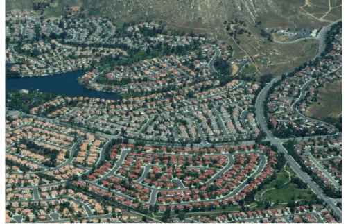
Figure 12.1. Typical post-suburbia in southern California. A master-planned development in Moreno Valley, Riverside County. Source: R. Le Goix, G. Averlant, M. Schwarz, April 2010.
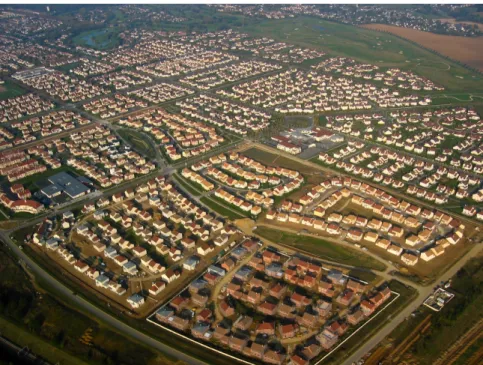
Figure 12.2. Residential subdivisions in Bussy-Saint-Georges (Ville Nouvelle, Marne-la-Vallée), 2007. Marne-la-Vallée’s new town program is often describe as an “edge city,” a “boomburb,” and a model of “new urbanism.” Source: Le Goix, Debicki, 2007.
Recently the term “boomburb” has become increasingly common as an analytical category adopted from the United States. Chalard (2011) has explicitly used it to analyse the dynamics of fifty-four French suburban municipalities with populations of more than 10,000 located in the outer suburban rings around larger metropolitan areas (specifically Paris, Aix-Marseille, Lyon, Rennes, and Toulouse). The term “baby boomburbs” refers to smaller municipalities following the same dynamics (Chalard, 2011). Originally coined by Lang and LeFurgy (2007), the term specifically refers to a trend identified since the 1970s. They define “boomburbs” as “having more than 100,000 residents, as not the core city in the their region, and as having maintained double-digit rates of population growth for each census since the beginning year (1970)” (6). Neither Chalard nor Lang and LeFurgy actually discuss the arbitrary (yet very symbolic) choice of thresholds (within a range of 10,000 to 100,000 inhabitants), but they nevertheless use the “boomburb” category as a heuristic device in their analyses of sub-central growth and suburban fragmentation in larger metropolitan regions. They describe “boomburbs” as “accidental cities” because of their lack of planning. In addition, they point to the lack of political recognition such developments are accorded, especially when compared to major central cities.
Another trend consists of using analytical concepts classically framed for studying U.S. social, racial, and ethnic segregation dynamics and integrating them into the French debate on city planning and urban public policies, although Wacquant (2008), among others, has clearly demonstrated the risks of the comparison. After Blakely and Snyder’s (1997) analysis of gated communities, much attention has focused on the contributions of such proprietary neighbourhoods to segregation in the United States (Le Goix, 2005; Le Goix and Vesselinov, 2015). In terms of transferring analysis from the United States to the French context, a seminal paper by Donzelot (1999) illustrates the trend. It considers the rise of forms of urbanism based on interpersonal affinity in post-industrial cities, analysing in particular “secessionists” neighbourhoods such as gated and lifestyle communities. He discusses the transfer of normative planning practice: “In the U.S., this suburbanization has become a dominant model, to the point that the population living in the suburbs (a suburbia that broke its ties with the city center) exceeds the total population living in cities or in the countryside. Although with a later start, it seems that the process of suburbanization in European cities will be following the same path, even making up for the lost time” (Donzelot, 1999: 100; my translation).
Scholar usually argue for similarities between US and European suburbanism in all of the following dimensions: landscapes, of course, but also institutional arrangements (homeowner regimes and private urban governance), the sense of place and
centre-periphery relationships, as well as a demand-side analysis for enhanced local security. Some scholars stress institutional contexts and insist that there are many common patterns although systems of local governance are different (Jaillet, 1999; Charmes, 2009).
“French periurbs approximately correspond to the outer suburbs and metropolitan fringes, or to what are more and more often called ‘exurbs’ in the U.S. Yet, unlike American exurbs, which in many cases are governed at the county level, French suburbs have always been governed by municipalities – that is, at the territorial level of the commune, the smallest unit of local government in France” (Charmes, 2009: 189).
Indeed, debates on the rise of residential privatism, gated communities, and socio-spatial fragmentation have highlighted the specificity of the French context in terms of such fragmentation and the specific role of a sense of place captured by a downtown/peripheries dichotomy that manifests itself in terms of a sense of urbanity: “European cities have resisted the adoption of American-style security-oriented and fragmented forms of urbanism, as described by David Mangin in La ville franchisee, (2004). This is explained by historical factors that allowed European cities to turn more slowly into franchised cities” (Mongin, 2013: 61; my translation).
For instance, suburbanization driven by the massive use of automobiles, commercial urbanism, and individual housing has led to some oversimplifications in loosely comparing
both contexts: “In Europe, car-driven development went from the inner city to the countryside, whereas in the U.S., it went from the countryside to the city. In France, suburban individual housing emerged late, although it has always existed in the U.S. … The attractiveness of historical centres, efficient radial mass transport networks, the taste for public space, and a strong municipal tradition have opposed a North American culture
of privatism” (Mangin, 2009; my translation).
Some scholars have examined security and have analysed the rapid adoption of security-oriented forms of urbanization and gated communities, comparing American and French trends (Billard et al., 2005). They deploy U.S. concepts to explain the rise of local dynamics of privatism, enclaves, and gated subdivisions as well as the derivatives of NIMBY-ism and defensible space in France (Loudier-Malgouyres, 2013). Yet, many authors underestimate some historical patterns, such as the adoption of identical planning practices for the romantic suburbs (individual housing in elite residential estates) in the 1830s, both in the United States and in France. These practices have strongly determined the structure of property ownership and the early adoption of private residential governance and homeowner associations in both contexts (Fourcaut, 2000; Le Goix and Callen, 2010). This discussion shows that many scholars contend that borrowing descriptive or analytical categories from American post-suburbanism might be useful in constructing categories to capture changing patterns in the outermost ring of suburbs in France. Nevertheless, I contend that several problems arise from this practice. The next section examines a series of issues related to the statistical categories at stake, and the geographies of suburbia as they are inferred when borrowing North American concepts.
Comparing with Bias and Nearsightedness
The respective statistical agencies of France and the United States use different criteria when defining urban and suburban boundaries. As noted in the introduction to this volume, words, including those related to statistics “qualify, divide, and classify reality”; with respect to analogies between French périurbain and U.S. suburban areas, words also can convey a false sense that similar spatial dynamics are being compared.
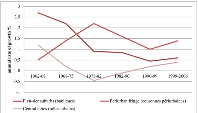
Périurbain is a statistical category in France (figure 12.3). The French National
Institute for Statistics and Economic Studies (Institut national de la statistique et des etudes économiques – INSEE) coined the concept aires urbaines (urban areas) in the late 1990s, dividing them into two main rings: the agglomeration (a continuously built-up area) and the peri-urban fringe. Using the geography of municipal boundaries, this fringe is defined as a continuous territory with fragmented urbanization according to two criteria: that it is at least 200 metres from the continuously built-up area, and that at least 40 per cent of its workers commute to the central cities. The definition has changed over time, but since 2010, these central cities (pôles urbains) have been agglomerations of more than 1,500 jobs for minor centers; 5,000 to 10,000 jobs for medium-size centres; and more than 10,000
jobs for major centers. Only major centers are actually classified as central cities of urban areas (aires urbaines).3 In the first decade of this century, the average size of suburban municipalities was 820 inhabitants (Charmes, 2009), and an estimated 29 per cent of the French population country lived in these statistical suburban areas, according to the 2010 definition.
Besides the statistical category itself, French suburbs are usually analysed as a set of successive rings. The first bourgeois suburbanization developed in residential estates close to railway stations in the late nineteenth century, and blue-collar workers progressively moved to single-family housing in the first industrial housing suburbs during the first half of the twentieth century, encourages by a state incentive offering preferential loans for first-time home buyers (Fourcaut, 2000).4 After the Second World War, population growth in France was fuelled by the continuous expansion and densification of urban areas. Nationally, suburbanization dynamics were preeminent between 1975 and the 1990s (see figure 12.3). Three categories of housing prevailed: first, tract housing in large subdivisions called nouveaux villages – which were directly inspired by Levittown on Long Island, New York (and thus described as à l’américaine, or American-style) – especially in the vicinity of the growing Paris metropolitan region; second, smaller subdivisions attached to small countryside villages (rurbanisation); and, last but not least, unorganized and scattered single-family homes built on former individual agricultural lots (mitage). This dynamic has been supported by state-driven incentives to increase homeownership from the 1960s on and bolstered by a reform of housing benefits in 1977.
Outer suburbs have long been regarded as the locus for the lower middle class, excluded from more central locations by the high cost of housing. However, some studies have sought to show a greater diversity in population (Berger, 2004; Jaillet, 2004). In France, suburbanization is seen mostly as a movement of residential loosening that cannot be easily compared to the edgeless city (Lang, 2003). Indeed, urban centres have remained the major places of employment; in 2010, suburban areas as a whole account for 12 percent of jobs, whereas a quarter of employees are suburbanites. This growing discrepancy between place of residence and place of work feeds an intense growth of commuting trips between centres and peripheries. However, the suburbs have seen a level of job diversification beyond simply jobs associated with residential services; in addition, there has been a growing trend towards sub-centring in connection with the emergence of secondary job centres (Chalonge and Beaucire, 2007; Drevelle, 2012).
Figure 12.3. Suburbanization dynamics in France, 1962–2006 (central cities with at least 5,000 jobs). Source: Insee, in Baccaïni et al., 2009. Adapted by the author.
The early process of suburbanization in the United States started in the mid-nineteenth century, with the upper classes escaping central city growth, social promiscuity, and the influx of immigrants in inner cities (Jackson, 1985; Fishman, 1987). After the Second World War, the suburbanization movement intensified; it could be differentiated according to three different phases, which were characterized by public investment in highways, change in transportation systems, and state support for the mortgages of middle-class households (Fishman, 1987; Lang et al., 2006). Indeed, the federal government conducted a proactive policy that has fuelled individual property and homebuilding in suburban tract housing (e.g., loan guarantees through the Federal Housing Administration and tax deductions for first-time buyers).5 The first phase of mass suburbanization in the 1950s was based on a continuous sprawl of residential areas for the white middle and working classes. A second stage in the 1970s saw the culmination of the development of shopping centres, services, and amenities. In the 1980s, a third wave of postwar suburbanization, led by the decentralization of employment centers, resulted in the creation of suburban centres that were increasingly independent of the central city, and a more diverse pattern of social and ethno-racial suburban stratification and assimilation (Alba et al., 1999; Clark, 2006; Logan, 2013).
In France, municipalities are officially defined as suburban by ad hoc census categories constructed by the census institute (INSEE). In the United States, however, suburbanization is not officially defined by the Bureau of the Census; it defines only
-1 -0,5 0 0,5 1 1,5 2 2,5 3 1962-68 1968-75 1975-82 1982-90 1990-99 1999-2006 annual r at e of gr ow th %
First-tier suburbs (banlieues) Periurban fringe (couronnes périurbaines) Central cities (pôles urbains)
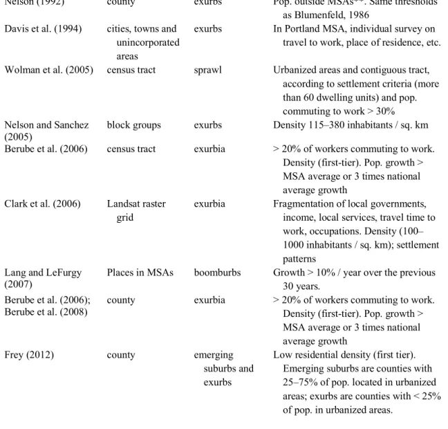
individual urban and rural areas.6 The suburban categories used in the literature are derived from the geography of the metropolitan statistical areas (MSA) typology (see figure 12.4). Suburban categories constructed by Frey (2012) are aggregations of counties within the hundred largest metropolitan areas, which are classified into four categories: city/high density suburb, mature suburb, emerging suburb, and exurb. By doing so Frey (2012), among others, highlights the rapid dynamics of suburbs, and in particular the sharp growth of the outer suburban rings and the relative decline of mature suburbs, with some rapid fluctuations after 2005.
The lack of an official statistical definition of “suburb” raises methodological questions in any analysis of the different phases of suburbanization (Le Goix, 2016). Neighbourhood characteristics are helpful in discussing the different types of suburbs – for example, in terms of functions, densities and urban attributes, the share of commuters, the pioneering position, the share of homeownership, and new developments:
While not officially classified by the Census Bureau, low-density outer suburbs and exurbs are typically contrasted with inner, more urbanized suburbs that have many of the attributes of core cities. These outer suburbs often contain more residents (many commuters) than workers, and have typically been the frontiers of population growth in both fast and modestly growing metropolitan areas, often due to more new and affordable homeownership opportunities. (Frey, 2012: 11)
Studying suburban dynamics in the United States with government statistics involves working with sometimes inadequate geographical resolution, consisting either of counties peripheral to the central county (see table 12.1), or areas outside of the MSA city centre (Frey, 2012). This inadequacy has been discussed in academic papers. Nelson and Sanchez (2005: 43) comment that “The research questions posed … require a finer grain of geographic resolution. After all, how can we measure exurbanization in San Bernardino County, California, which has decidedly urban, suburban, exurban, and rural development – and is larger than most New England states?”
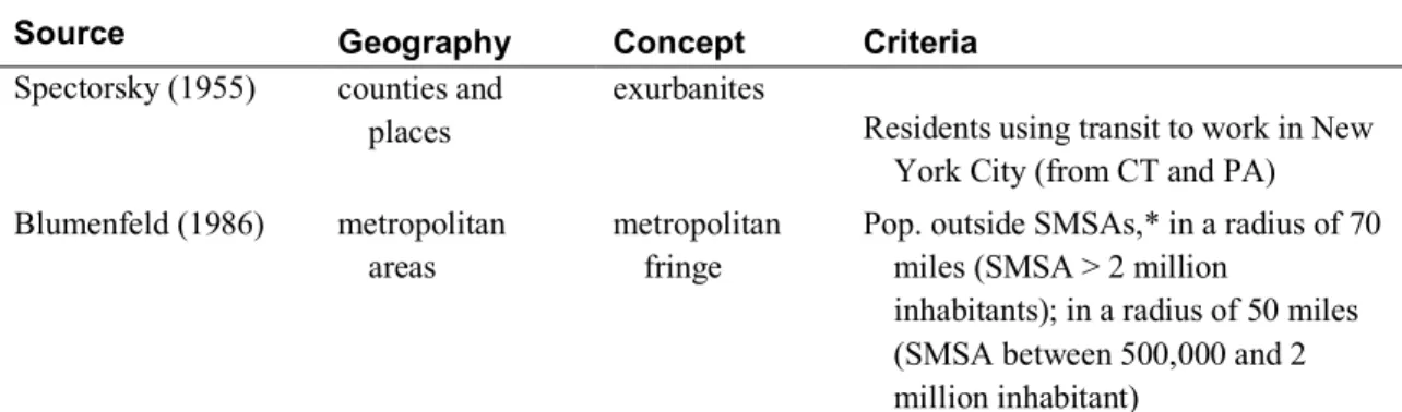
Table 12.1 Competing definitions: Examples of the geographies, concepts, and criteria used to characterize the dynamics of suburbs and exurbs in the United States
Source Geography Concept Criteria
Spectorsky (1955) counties and places
exurbanites
Residents using transit to work in New York City (from CT and PA) Blumenfeld (1986) metropolitan
areas
metropolitan fringe
Pop. outside SMSAs,* in a radius of 70 miles (SMSA > 2 million
inhabitants); in a radius of 50 miles (SMSA between 500,000 and 2 million inhabitant)
Nelson (1992) county exurbs Pop. outside MSAs**. Same thresholds as Blumenfeld, 1986
Davis et al. (1994) cities, towns and unincorporated areas
exurbs In Portland MSA, individual survey on travel to work, place of residence, etc. Wolman et al. (2005) census tract sprawl Urbanized areas and contiguous tract,
according to settlement criteria (more than 60 dwelling units) and pop. commuting to work > 30% Nelson and Sanchez
(2005) block groups exurbs Density 115–380 inhabitants / sq. km Berube et al. (2006) census tract exurbia > 20% of workers commuting to work.
Density (first-tier). Pop. growth > MSA average or 3 times national average growth
Clark et al. (2006) Landsat raster grid
exurbia Fragmentation of local governments, income, local services, travel time to work, occupations. Density (100– 1000 inhabitants / sq. km); settlement patterns
Lang and LeFurgy
(2007) Places in MSAs boomburbs Growth > 10% / year over the previous 30 years. Berube et al. (2006);
Berube et al. (2008)
county exurbia > 20% of workers commuting to work. Density (first-tier). Pop. growth > MSA average or 3 times national average growth
Frey (2012) county emerging suburbs and exurbs
Low residential density (first tier). Emerging suburbs are counties with 25–75% of pop. located in urbanized areas; exurbs are counties with < 25% of pop. in urbanized areas.
* Standard Metropolitan Statistical Areas ** Metropolitan Statistical Areas
Table 12.1 summarizes some of the concepts and criteria analysed in reports and scholarly works to define the recent phases of suburban development. The geographical sensitivity of the evaluation of suburban dynamics shows different practices: some prefer to rely on a finer grain, such as suburban places and municipalities where available (Lucy and Phillips, 2001), whereas others consider the availability of data and dismiss the question of the unit of analysis (Berube et al., 2008).
Figure 12.4. Annual growth rate by county urbanization, large metro areas, 2000–10. Source: Adapted by the author, from Frey, W. (2012).
While it is often assumed that French and U.S. suburbs can be easily compared in terms of processes and dynamics, the comparison falls short with respect to context, statistical terms, and categories. On the one hand, the French definition is static and considers as strictly suburban only the outer ring of the urban edge, where leap-frog development dominates the landscape. On the other hand, in the United States, suburbs are defined as a component of MSAs (a geographic unit composed of entire counties), a definition that lacks a convenient geography because the spatial unit or geographical resolution (based on counties) is considered to be too large to actually account for the structural differences between the different stages of urbanization (Nelson and Sanchez, 2005).
Considering the problem of statistically defining the elements of suburbia, in both cases the analysis of suburbanism, sprawl, and the outer periphery is constrained by a logical trap, or a relative mismatch, between a priori categories defined by official statistics and the categories and objects actually existing and observed in the built environment in a very fragmented landscape.
Planning Suburbia as Places and Mass
Consumption Products
The fragmentation of suburbia is not only morphological, but also political. When comparing patterns in France and the United States, scholars and planners not only compare two incompatible statistical systems, but they also introduce an analytical bias, as they do not refer to the same geographical, planning, and political objects. An important
-0,5 0,0 0,5 1,0 1,5 2,0 2,5 2000 / 2001 2004 / 2005 2009/2010
City / Dense Suburbs Emerging Suburbs
Mature Suburbs Exurbs
point to address is how residential subdivisions are planned and produced as places,
neighbourhoods, and mass consumption products. Developers typically package
residential estates as neighbourhoods. The houses are built and delivered with a certain level of services, lifestyle, and amenities (i.e. access to a golf course, parks, leisure facilities, and so on) and a bundle of rights attached to the residence, which will define its characteristics and price.
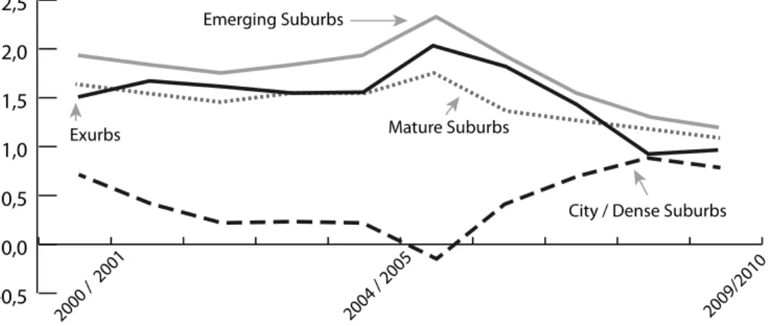
In the United States, the most generic terminology used by experts and planners to refer to suburbs are “subdivisions” and “planned developments.” A “subdivision” consists of the division, by any subdivider, of parcel(s), serviced or not, previously identified in the property tax rolls as a single unit, in order to be sold, rented, or serve as investment.7 “Planned development” or “Planned unit development” (PUD) is a category found mostly in planning documents. If we consider the state of California alone, PUD represents up to 52 per cent of proposed new housing (see table 12.2).8 Such a project must include maps and regulations (parcel maps, tentative and final maps), as well as the various ordinances issued by regulatory authorities, the phasing of the project, and infrastructure works required for the project (Knox and Knox, 1997). Most housing estates follow PUD planning procedures. The schemes are governed by regulations and run by associations, which remain the owners of all public areas, including streets. The homeowner is an ex officio member of the association.
Large exurban tract housing developments are called “master-planned communities,” defined as new urban developments on agricultural or vacant land that are subject to a general planning process negotiated and discussed with the authorities, and in which the developers gain complete land control. This type of project – which can be seen, for example, in Radburn, New Jersey, Sun City in Arizona or – belongs to an intermediate planning scale, between the large subdivision and the new town. Even though the lineage between master-planned communities and new town projects is obvious, the latter usually pertain to large integrated urban projects, combining higher density, a greater mix of land use, the development of local job hubs, commercial and recreational amenities, transportation (e.g., rail transit systems, a regional airport) with special attention given to the quality of life and social diversity of the project, as in Irvine, California. Governments are often directly involved in the planning effort, even if the project is operated by a private body of governance (as in Irvine) (Forsyth, 2002).
In general, major suburban development projects from the 1960s in the United States have been characterized by a social utopia vision: in Columbia, Maryland, for example, James Rouse, the developer, envisioned the project as a community allowing a racial mix (Kato, 2006). Irvine, California, and Woodlands, Texas, were developed as “balanced communities,” a term that designates a social and racial mix and a balance between the number of residents and jobs, while land use planning allowed for the provision of social housing (Forsyth, 2002).
Table 12.2. Categories of subdivisions approved in California between 2000 and 2010 (development permits and housing units)
California Southern California
Dev. permits Housing units % Dev. permits Housing units % Community apartment 23 337 0.02 13 204 0.02 Condominium 15,459 559,469 37.3 11,339 379,585 41.9 Planned development 23,271 756,316 50.4 16,600 472,814 52.2 Standard 4,069 155,859 10.4 943 41,624 4.6 Timeshare 254 19,543 1.3 75 7,348 0.8 Other 579 9,946 0.6 90 4,805 0.5 Total 43,655 1,501,470 100 29,060 906,380 100
In France, the generic terminology used in planning documents as well as in the academic and non-academic literature to describe tract housing is lotissement (literally, subdivision). Generally speaking, a subdivision is primarily a legal planning category, a transaction that subdivides a lot into at least two lots. The actual construction of the structure on such subdivided lots must occur within ten years after the subdivision permit is granted. Following the massive wave of blue-collar “failed” subdivisions (lotissements
défectueux) in the early twentieth century that were developed with insufficient
infrastructure (Fourcaut, 2000), subdivisions have been regulated by a series of laws and decrees that requires the developer to provide utilities, allows municipalities to finance the acquisition of unsold or ill-equipped lots, and to enhance urban design.9
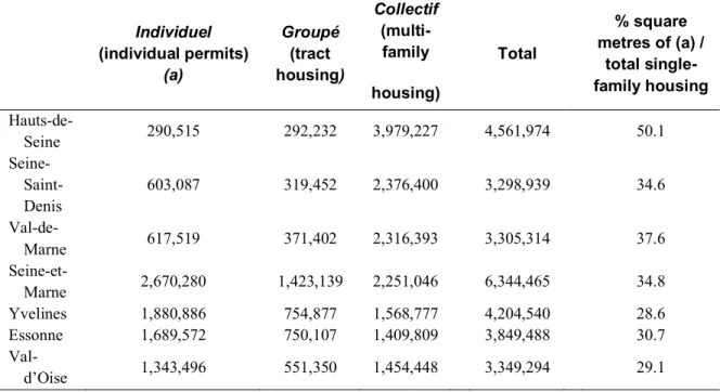
Planning for a development consisting of single-family homes is tightly regulated. Such a development requires a legal arrangement that produces a specific space in the urban and suburban landscape. The subdivision process requires control over land. Local authorities, such as a municipality or private entities (e.g., landowner, developer, real estate company), may own the land to be developed. The term lotissement is, however, a confusing category, as it is often used to loosely and indifferently describe various forms of types of single-family housing, suburban landscapes, and different forms of legal arrangements. Public databases (e.g., the Sit@del2 database) do little to clarify matters, as permit statistics differentiate only two categories of single-family housing (table 12.3). The first category, individuel (for “individual permits”) pertains to both individual houses built on rural lots (mitage) and subdivisions with single-family homes. In the latter case, a two-step procedure is required: the subdivider applies for a permit before selling vacant lots, then builders apply for an individual building permit for each home. At least two actors are involved in this case: a subdivider and a builder of individual houses, the builder being an individual choosing a house from a homebuilder catalogue, or opting for a popular self-construction system (Bourdieu, 2000). As shown in table 12.3, the “individual” category represents up to 50–70 per cent of individual housing built in the Paris region. Another
are planned under the groupé category, the developer files a single development permit, and then sells the built properties individually after full completion of the project. This planning category leads to the greatest architectural homogeneity (see figure 12.2), and is therefore also referred to in the general literature (as in the famous Telerama paper describing the ugly suburban landscapes, La France moche, De Jarcy and Remy, 2010) as the quintessential model of lotissements that were massively produced between the 1970s and the late 1990s by international developers, although it is not recognized under the legal category of a lotissement. Therefore, although apparently convergent, the residential developments differ in their legal basis, their logic, and their production locations (see table 12.3), in the actors involved in production, and in the market segments they are targeting, with regional or international developers focusing on different niche markets or particular areas in the region (Vilmin, 2005; Callen, 2011).
Table 12.3 Housing typology by type of permit and surface area of new housing built in Ile-de-France between 1999 and 2007
Single-Family Housing Individuel (individual permits) (a) Groupé (tract housing) Collectif (multi-family housing) Total % square metres of (a) / total single-family housing Hauts-de-Seine 290,515 292,232 3,979,227 4,561,974 50.1 Seine-Saint- Denis 603,087 319,452 2,376,400 3,298,939 34.6 Val-de-Marne 617,519 371,402 2,316,393 3,305,314 37.6 Seine-et-Marne 2,670,280 1,423,139 2,251,046 6,344,465 34.8 Yvelines 1,880,886 754,877 1,568,777 4,204,540 28.6 Essonne 1,689,572 750,107 1,409,809 3,849,488 30.7 Val-d’Oise 1,343,496 551,350 1,454,448 3,349,294 29.1
Governance
Governance is another important dimension to be considered when comparing suburban dynamics in France and the United States: “the mutation of suburban into post-suburban ideology and politics has entailed governance at new spatial scales” (Phelps and Wood, 2011: 2601). The boundaries of settlements, residential subdivisions, or edge cities rarely coincide with already established institutional boundaries. At a local level – that of the neighbourhood or municipality – post-suburbanism introduces a blurring of lines
between private and public governance (Fishman, 1987), which is associated with a fragmentation or “splintering” of the provision of infrastructure and service (such as public transportation, power and water supply, and sewerage) and a privatized structure of governance building upon a club economy (Webster, 2003 and 2007; Webster and Glasze, 2006). Indeed, an array of terms describing the blurred boundaries between the public and private governance of suburban areas (“private urban governance,” “private neighbourhoods,” “clubs,” and so on) has been widely adopted by scholars discussing exclusionary urbanism, privatism, and secessionist attitudes (Donzelot, 1999), but also by planners and architects (Loudier-Malgouyres and Vallet, 2010; Loudier-Malgouyres, 2013; Mongin, 2013) and by commentators and journalists describing the privatization of civic space in suburbs. The governance perspective requires a clarification of the terminology used and the level of governance it describes.
Many analysts describe the implementation of private urban governance as a side effect of the most recent phases of suburbanization, and, indeed, planned communities, homeowners’ association, and gated communities do implement forms of private urban governance (McKenzie, 1994 and 2001; Glasze et al., 2006). The implementation of infrastructure (e.g., water, sewage) is often transferred to districts and paid for by homeowners through non-fiscal levies. Ad hoc municipalities have also been created, which are instrumental in transferring public money for the use of large planned developments and gated communities. A study in the region of Los Angeles showed that these are, in many cases, fully incorporated municipalities, while some special purpose districts are also common instruments (Le Goix, 2006).
Legally speaking, all forms of residential subdivisions and planned communities rely on property rights arrangements and regulations, implemented by homeowners associations (HOAs) or property owners associations (POAs) that are designed to exclude outsiders and protect property values. These governing bodies are formed by residents tied by contract to a common set of interests (McKenzie, 1994); a variety of such contracts have been used in different local contexts, more generally named Common Interest Developments (CIDs). Gated communities and walled neighbourhoods are members of this CID class that includes master-planned communities and condominiums governed by collective tenure and incorporated organizational arrangements (Glasze, 2005). Such morphologies rely on forms of scrutiny as social strategies support comfort and social homogeneity (Low, 2003; Gordon, 2004; Kirby, 2008). Gated communities became, for some, both symbols and symptoms of a line that is being crossed from voice-based citizenship to exit-based citizenship (Tiebout, 1956; Foldvary, 1994) and from politically organized to market-based civic society and neighbourhoods.
The economic theory of clubs (Buchanan, 1965) challenges the neoclassical notion of public goods. A club, in economics, is a method of supplying jointly consumed goods efficiently on the basis of controlled membership and fees. This line of argument sees private urban governance in terms of neither public nor private spaces. Rather such
governance is viewed in terms of club spaces – spaces governed by “small publics” – that is, homeowners associations and shareholders. Compared to classical municipal governments, they are alleged to be more efficient organizations for allocating scarce resources, for a number of reasons. Residents can vote with their feet and choose the bundle of shared goods and services they prefer at a given price. From this derives a comparison between the club community market and the spatial economy of Charles Tiebout (1956). The exclusionary mechanism of “membership” means that there is a more precise relationship between payment and benefit received than there is in publicly managed neighbourhoods. Significant investments made by POAs are capitalized in land rents. Not only do owners have an incentive to invest in their local environments but they can also recover investment costs from rents. The sustainability is ensured by the existence of the POA, which has three basic characteristics: elected boards act as neighbourhood decision makers; contracts govern resident behaviour (through convenants, conditions, and restrictions, CC&Rs); and monthly fees finance local amenities and services. By interpreting private urban governance as a mechanism for supplying environments, security, and other goods and services that are neither private nor public goods, the club economy model allows a more nuanced and specific debate about the roles of markets and governments in shaping, governing, and managing the city.
In the United States, this club economy realm has been adopted to describe the very fragmented political structure produced by private neighbourhoods and master-planned communities (Le Goix, 2006), and to analyze how it contributes to a greater sense of place, neighbourhood building, or sense of community (Kirby, 2008). But in France, authors such as Charmes (2009) and Jaillet (1999) contend that small municipalities (with an average population 820 inhabitants) are local bodies of government whose principles perfectly match those of the club economy, as a local organization managing the interest of its members, most notability by means of slow-growth policies and control of land use. There is no need to build large, privately governed, planned communities to create exclusive neighbourhoods from scratch in France, as small municipalities perfectly implement exclusionary policies. Indeed, a mayor of such a municipality is allowed to determine zoning regulations and the type of authorized construction (collective or individual housing, for example). Periurban municipalities govern the provision of goods and control social homogeneity:
The impact of land use by-laws and of local policies on building values (through “capitalisation”) allows action to be taken on the entry fee required to be part of the municipality. Annual dues associated with residency in the municipality can also be set through local taxes … French periurban communes [municipalities] are an environment conducive to the formation of a market of bundles of local collective goods. (Charmes, 2009: 193)
Furthermore, a well-established policy regarding land use and planning in these smaller municipalities is to maintain a belt of rural and agricultural land around the built-up area (see figure 12.3). As the built-up area remains a modest size, it frequently appears to be isolated. When this built-up area is underlined by the relief of the surrounding natural or agricultural land, the visual effect of an “autonomous village” can be striking. The place-building process in French post-suburbs are the landscapes resulting from planning policies and municipal by-laws arranging the entry fee, and planning choices that are dedicated to sorting and selecting prospective homebuyers. For instance, real estate agents often advertise not only the property and the seclusion, exclusivity, and tidiness of the built environment, but also the level of services nearby (e.g., schools, parks, recreation, transportation), and this level of service has an explicit influence on locational choice; this is the case in French as well as in U.S. suburban contexts (Berube et al., 2006; Le Goix and Callen, 2010).
Conclusion
When describing French dynamics of outer suburbanization, many American terms have been borrowed by analysts and academics, and these words have been integrated into planning practices and analytical categories. Many problems arise with this procedure, from (at least) three sources. First, the respective statistical agencies of the two countries use different criteria in defining urban boundaries, boundaries that define the spaces to which researchers and planners must refer. Second, settlement patterns differ, most notably because places of employment have decentralized more slowly around French than U.S. cities. Third, the local governance associated with planned communities strongly differs in the two countries. Whereas in France the municipal level conveys sufficient control for homeowners, such local control is better performed through private urban governance structures in the United States. The municipal power in France can also be strong enough to allow growth while controlling the population influx (see the discussion in Anne Lambert’s chapter below). Purchasing a property within a private planned development in the United States or within a small “publicly operated and developed” lotissement in France is not only a way to access a bundle of rights over the property, but it also comes with a set of services and amenities that are implicitly bundled with the properties. This bundle derives mostly from the municipal provision of services, implemented according to club principles in France while in the United States the club realm derives from the HOA system. Comparing French and U.S. post-suburbs requires a careful look at the finer local grain of analysis that actually allows comparison: how post-suburban neighbourhoods and developments are legally (planning), politically (clubs), and socially constructed at the local level.
References
Alba, R.D., J.R. Logan, B.J. Stults, G. Marzan, and W. Zhang. 1999. “Immigrant Groups in the Suburbs: A Reexamination of Suburbanization and Spatial Assimilation.” American Sociological Review 64 (3): 446–60. http://dx.doi.org/10.2307/2657495.
Baccaïni, B., and F. Sémécurbe. 2009. “La croissance périurbaine depuis 45 ans: Extension et densification.” Insee Première (June). https://www.insee.fr/fr/statistiques/1280801. Berger, M. 2004. Les périurbains de Paris. Paris: CNRS Editions.
http://dx.doi.org/10.4000/books.editionscnrs.9397.
Berube, A., R. Lang, and T. Sanchez. 2008. “The New Suburban Politics: A County-Based Analysis of Metropolitan Voting Trends Since 2000.” In Red, Blue, and Purple America: The Future of Election Demographics, edited by R. Teixeira, 25–49. Washington, DC: Brookings Institution Press.
Berube, A., A. Singer, J. Wilson, and W. Frey. 2006. “Finding Exurbia: America’s Fast-Growing Communities at the Metropolitan Fringe.” In Living Cities Census Series. Washington, DC: Brookings.
Billard, G. 2010. “Smart growth: Un nouvel urbanisme américain ... durable”. Urbanisme. Hors série: la démarche écocité, villes durables en projet 36: 62–64.
Billard, G., J. Chevalier, and F. Madoré. 2005. Ville fermée, ville surveillée: La sécurisation des espaces résidentiels en France et en Amérique du Nord. Rennes: Presses Universitaires de Rennes. http://dx.doi.org/10.4000/books.pur.1784.
Blakely, E.J., and M.G. Snyder. 1997. Fortress America, Gated Communities in the United States.. Washington DC and Cambridge, MA: Brookings Institution Press and Lincoln Institute of Land Policy.
Blumenfeld, H. 1986. “Metropolis Extended: Secular Changes in Settlement Patterns.” Journal of the American Planning Association 52 (3): 346–48. http://dx.doi.org/10.1080/01944368608976441. Bontje, M., and J. Burdack. 2011. “Post-suburbia in Continental Europe”. In International Perspectives on
Suburbanization: A Post-Suburban World? edited by N.A. Phelps and F. Wu, 143–163. Basingstoke, UK: Palgrave Macmillan. http://dx.doi.org/10.1057/9780230308626_8. Bourdieu, P. 2000. Les structures sociales de l’économie. Paris: Le Seuil.
Buchanan, J.M. 1965. “An economic theory of clubs.” Economica 32 (125): 1–14. http://dx.doi.org/10.2307/2552442.
Callen, D. 2011. La “fabrique péri-urbaine”, système d’acteurs et production des ensembles pavillonnaires dans la Grande Couronne francilienne. Doctoral thesis, Université Panthéon-Sorbonne - Paris 1, Paris.
Chalard, L. 2011. “Des boomburbs à la française.” Population et Avenir 2011/5,705:15–17.
Chalonge, L., and F. Beaucire. 2007. Le desserrement des emplois au sein des aires urbaines: Dépendance, autonomie, ou intégration?” Annales de la recherche urbaine 102 (1): 97–101.
http://dx.doi.org/10.3406/aru.2007.2698.
Charmes, E. 2005. La vie périurbaine face à la menace des “gated communities”. Paris: L’Harmattan. 2009. “On the Residential ‘Clubbisation’ of French Periurban Municipalities.” Urban Studies (Edinburgh,
Scotland) 46 (1): 189–212. http://dx.doi.org/10.1177/0042098008098642.
Choplin, A., and M. Delage. 2014. L’est parisien, un territoire sans qualité? Métropolitiques , 10 September. http://www.metropolitiques.eu/L-est-parisien-un-territoire-sans.html.
Clark, J., R. McChesney, D.K. Munroe, and E.G. Irwin. 2006. “Exurban Settlement Pattern and the Exurban Condition: A Typology of U.S. Metropolitan Areas.” In 53rd Annual North American Meetings of the Regional Science Association International. Toronto, CA.
Clark, W.V. 2006. “Race, Class, and Space: Outcomes of Suburban Access for Asians and Hispanics.” Urban Geography 27 (6): 489–506. http://dx.doi.org/10.2747/0272-3638.27.6.489.
Davis, J.S., A.C. Nelson, and K.J. Dueker. 1994. “The New ’Burbs: The Exurbs and Their Implications for Planning Policy.” Journal of the American Planning Association 60 (1): 45–59.
http://dx.doi.org/10.1080/01944369408975551.
De Jarcy, X., and Remy, V. 2010. Comment la France est devenue moche. Télérama, 13/02/2010. Donzelot, J. 1999. “La nouvelle question urbaine.” Esprit (Paris) 258: 87–114.
Drevelle, M. 2012. “Structure des navettes domicile-travail et polarités secondaires autour de Montpellier.” Mappemonde 107: 2012–13.
Fishman, R. 1987. Bourgeois Utopias: The Rise and Fall of Suburbia. New York: Basic Books. Foldvary, F. 1994. Public Goods and Private Communities: The Market Provision of Social Services.
Aldershot, UK: Edward Elgar.
Forsyth, A. 2002. “Who Built Irvine? Private Planning and the Federal Government.” Urban Studies (Edinburgh, Scotland) 39 (no. 13): 2507–30. http://dx.doi.org/10.1080/0042098022000027086. Fourcaut, A. 2000. La banlieue en morceaux: La crise des lotissements défectueux en France dans
l’entre-deux-guerres. Grâne, FR: Créaphis.
Frey, W. 2012. “Population Growth in Metro America since 1980: Putting the Volatile 2000s in Perspective.” In Metropolitan Policy Program. Washington, DC: Brookings Institution. Garreau, J. 1991. Edge City: Life on the New Frontier. New York: Doubleday.
Gasnier, A. 2006. “Le Val d’Europe à Marne-La-Vallée: Mickey fait-il du développement durable?” In Working paper. Le Mans: Université du Mans, UMR ESO.
Ghorra-Gobin, C. 2010. “Réformer la suburbia: Un éclairage sur le débat américain prônant la densité.” Urbanisme 370: 33–38.
“Le New Urbanism, marqueur de fragmentation urbaine? ” Cahiers de géographie de Québec 55 (no. 154): 75–88.
Glasze, G. 2005. “Some Reflections on the Economic and Political Organisation of Private Neighbourhoods.” Housing Studies 20 (2): 221–33.
http://dx.doi.org/10.1080/026730303042000331745.
Glasze, G., C.J. Webster, and K. Frantz, eds. 2006. Private Cities: Global and Local Perspectives. London: Routledge and Taylor and Francis.
Gordon, T.M. 2004. Planned Developments in California: Private Communities and Public Life. San Francisco, CA: Public Policy Institute of California.
Gournay, I. 2002. “Levitt France et la banlieue à l’américaine, premier bilan.” Histoire urbaine 1 (no. 5): 167–188. http://dx.doi.org/10.3917/rhu.005.0167.
Jackson, K.T. 1985. Crabgrass Frontier: The Suburbanization of the United States. Oxford: Oxford University Press.
Jaillet, M.-C. 1999. “Peut-on parler de sécession urbaine à propos des villes européennes? ” Esprit (Paris, France) 11 (no. 258): 145–67.
2004. “L’espace périurbain: Un univers pour les classes moyennes.” Esprit (Paris, France) (no. 303): 40–62. Kato, Y. 2006. “Planning and Social Diversity: Residential Segregation in American New Towns.” Urban
Studies 43 (no. 12): 2285–2300. http://dx.doi.org/10.1080/00420980600950187.
Keil, R., and D. Young. 2011. “Post-Suburbia and City-Region Politics.” In International Perspectives on Suburbanization: A Post-Suburban World? edited by N.A. Phelps and F. Wu, 54–77. Basingstoke, UK: Palgrave Macmillan. http://dx.doi.org/10.1057/9780230308626_4.
Kirby, A. 2008. “The Production of Private Space and Its Implications for Urban Social Relations.” Political Geography 27 (1): 74–95. http://dx.doi.org/10.1016/j.polgeo.2007.06.010.
Knox, N.H., and C.E. Knox. 1997. The California General Plan Glossary. Palo Alto, CA, Planning Roundtable, Governor’s Office of Planning and Research.
Kuisel, R. 1993. Seducing the French: The Ddilemma of Americanization. Berkeley: University of California Press.
Lang, R. 2003. Edgeless Cities: Exploring the Elusive Metropolis. Washington, DC: Brookings Institution Press.
Lang, R., and J.B. LeFurgy. 2007. Boomburbs: The rise of America’s Accidental Cities. Washington, DC: Brookings Institution Press.
Lang, R., J.B. LeFurgy, and A.C. Nelson. 2006. “The Six Suburban Eras of the United States: Research Note.” Opolis: An International Journal of Suburban and Metropolitan Studies 1.
http://escholarship.org/uc/item/739425j0.
Le Goix, R. 2005. “Gated Communities: Sprawl and Social Segregation in Southern California.” Housing Studies 20 (2): 323–43. http://dx.doi.org/10.1080/026730303042000331808.
2006. “Gated Communities as Predators of Public Resources: The Outcomes of Fading Boundaries between Private Management and Public Authorities in Southern California.” In Private Cities: Global and local perspectives, edited by G. Glasze, C.J. Webster, and K. Frantz, 76–91. London: Routledge.
2016. Sur le front de la métropole. Une géographie suburbaine de Los Angeles. Paris: Publications de la Sorbonne.
Le Goix, R., and D. Callen. 2010. “Production and Social Sustainability of Private Enclaves in Suburban Landscapes: Local Contexts and Path Dependency in French and U.S. Long-term Emergence of Gated Communities and Private Streets.” In Gated Communities: Social Sustainability in Contemporary and Historical Gated Developments, edited by S. Bagaeen and O. Uduku, 93–114. London: Earthscan.
Le Goix, R., and E. Vesselinov. 2015. “Inequality Shaping Processes and Gated Communities in U.S. Western Metropolitan Areas.” Urban Studies (Edinburgh, Scotland) 52 (no. 4): 619–38. http://dx.doi.org/10.1177/0042098014532555.
Logan, J.R. 2013. “The Persistence of Segregation in the 21st Century Metropolis.” City and Community 12 (2): 160–68. http://dx.doi.org/10.1111/cico.12021.
Loudier-Malgouyres, C. 2013. “Le retrait résidentiel.” Esprit (Paris, France) no. 393: 61–67.
Loudier-Malgouyres, C., and B. Vallet, eds. 2010. Les cahiers de l’Institut d’Aménagement et d’Urbanisme de la région Ile-de-France. Volume 155. L’influence de la sécurité sur la conception urbaine. Paris: Institut d’Aménagement et d’Urbanisme Région Ile-de-France.
Low, S. 2003. Behind the Gates: Life, Security, and the Pursuit of Happiness in Fortress America. New York: Routledge.
Lucy, W.H., and D.L. Phillips. 1997. “The Post-suburban Era comes to Richmond: City Decline, Suburban Transition, and Exurban Growth.” Landscape and Urban Planning 36 (no. 4): 259–75.
http://dx.doi.org/10.1016/S0169-2046(96)00358-1.
Lucy, W.H., and D.L. Phillips. 2001. Suburbs and the Census: Patterns of Growth and Decline. Center on Urban and Metropolitan Policies Survey Series. https://www.brookings.edu/research/suburbs-and-the-census-patterns-of-growth-and-decline/.
Mangin, D. 2004. La ville franchisée: Formes et structures de la ville contemporaine. Paris: Editions de la Villette.
Mangin, D. 2009. “Les métropoles européennes dans l’après-crise.” Futuribles no. 354, July: 33–38. McKenzie, E. 1994. Privatopia: Homeowner Associations and the Rise of Residential Private Government.
New Haven, CT: Yale University Press.
2011. Beyond Privatopia: Rethinking Residential Private Government. Washington, DC: Urban Institute Press.
Merlin, P. 1991. Les villes nouvelles en France. Paris: Presses Universitaires de France.
Mongin, O. 2013. “Emiettement et exclusivisme social.” Esprit (Paris, France), no. 393 (March/April): 61– 67. http://dx.doi.org/10.3917/espri.1303.0061.
Nelson, A.C. 1992. “Characterizing Exurbia.” Journal of Planning Literature 6 (no. 4): 350–68. http://dx.doi.org/10.1177/088541229200600402.
Nelson, A.C., and T. Sanchez. 2005. “The Effectiveness of Urban Containment Regimes in Reducing Exurban Sprawl.” disP: The Planning Review, 41 (no. 160): 42–47.
http://dx.doi.org/10.1080/02513625.2005.10556905.
Phelps, N.A., and A.M. Wood. 2011. “The New Post-suburban Politics?” Urban Studies (Edinburgh, Scotland) 48 (no. 12): 2591–610. http://dx.doi.org/10.1177/0042098011411944.
Phelps, N.A., and F. Wu. 2011. “Introduction.” In International Perspectives on Suburbanization: A Post-Suburban World? edited by N.A. Phelps and F. Wu, 1–13. Basingstoke, UK: Palgrave Macmillan. http://dx.doi.org/10.1057/9780230308626.0007.
Picon, A., and C. Orillard. 2012. De la ville nouvelle à la ville durable: Marne-la-Vallée. Marseille: Parenthèses.
Spectorsky, A.C. 1955. The Exurbanites. Philadelphia: Lippincott.
Tiebout, C.M. 1956. “A Pure Theory of Local Expenditures.” Journal of Political Economy 64 (no. 5): 416– 24. http://dx.doi.org/10.1086/257839.
Vilmin, T. 2005. “Le système local de production de la maison individuelle.” In Maison individuelle, architecture, urbanité, edited by G. Tapié, 209–221. Editions de l’Aube, La Tour d’Aigues. Vogel, R. 1979. Le “Nouveau Village” français: Le projet et son idéologie. Paris: EHESS.
Wacquant, L. 2008. Urban Outcasts: A Comparative Sociology of Advanced Marginality. Cambridge: Polity Press.
Webster, C. 2003. “The Nature of the Neighbourhood.” Urban Studies (Edinburgh, Scotland) 40 (no. 13): 2591–612. http://dx.doi.org/10.1080/0042098032000146803.
2007. “Property Rights, Public Space and Urban Design.” Town Planning Review 78 (1): 81–101. http://dx.doi.org/10.3828/tpr.78.1.6.
Webster, C., and G. Glasze. 2006. “Dynamic Urban Order and the Rise of Residential Clubs.” In Private Cities: Local and Global Perspectives, edited by G. Glasze, C. Webster, and K. Frantz, 222–236. London: Routledge.
Wolman, H., G. Galster, R. Hanson, M. Ratcliffe, K. Furdell, and A. Sarzynski. 2005. “The Fundamental Challenge in Measuring Sprawl: Which Land Should Be Considered?” Professional Geographer 57 (no. 1): 94–105.
Wu, F., and N.A. Phelps. 2008. “From Suburbia to Post-Suburbia in China? Aspects of the Transformation of the Beijing and Shanghai Global City Regions.” Built Environment 34 (no. 4): 464–81. http://dx.doi.org/10.2148/benv.34.4.464.
1 Cf. the chapter by Topalov in the present volume: the terms villas (small private housing estate),
cités, and hameaux, have been used to distinguish between small subdivisions built by small local
developers, business owners, or trade unions.
2 The New Towns program (Villes Nouvelles) was originally planned in the mid-1960s along
principles such as compactness, higher densities, mixed land use, walkable centres with access to mass transit system corridors, and a local balance between jobs and housing so as to avoid uncontrolled sprawl on the peripheries of Paris, Lyon, Lille, and Marseille (Merlin, 1991).
3 See Anne Lambert’s chapter in the present volume for details regarding the périurbain statistical
category, and how this term remains irrelevant for most of the residents.
4 Cf. The chapter by Christian Topalov in the present volume.
5 As a remarkable long-term public policy, the Mortgage Interest Deduction, a major driver for
suburbanization in the twentieth century, has been applied to support the real estate industry after the subprime crisis, with a homebuyer tax deduction applied to homeowners who bought in 2008–9 and 2010. The author wishes to thank the reviewer for this input.
6 Urbanized areas (UAs) of 50,000 or more people; urban clusters (UCs) of between 2,500 and
50,000 people. “Rural” encompasses all population, housing, and territory not included within an urban area. https://www.census.gov/geo/reference/urban-rural.html
7 The term “subdivision” includes condominium or condominium-type projects as defined by
section 1350 of the California Civil Code, and apartment complexes as defined by section 11004 of the Business and Professions Code.
8 This chapter elaborates on data collected during projects involving field research in southern
California and the Paris metropolitan region (Île-de-France).
9 An act of 19 July 1924 (Loi du 19 juillet 1924) require the provision of utilities; decrees passed
in 1973, and an act of 31 December 1976 (Loi du 31/12/1976 portant réforme de l’urbanisme) allows municipalities to finance the acquisition of unsold or ill-equipped lots; and a decreee from 1977 enabled municipalties to enhance urban design.